CPAC: CALVIN - Post-Tropical - Discussion
Moderator: S2k Moderators
- Yellow Evan
- Professional-Met
- Posts: 15960
- Age: 25
- Joined: Fri Jul 15, 2011 12:48 pm
- Location: Henderson, Nevada/Honolulu, HI
- Contact:
Re: EPAC: CALVIN - Hurricane - Discussion
T5.5 instantaneously. Constraints factored in lowers to 5.0.
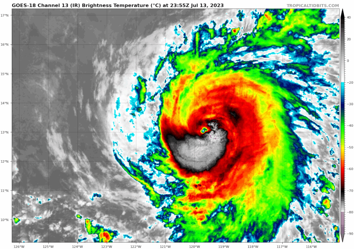
CB needs to wrap around but a decrease in banding and gradual increase in organization has made it much less vulnerable to dry air intrusions.
0 likes
- cycloneye
- Admin
- Posts: 139714
- Age: 67
- Joined: Thu Oct 10, 2002 10:54 am
- Location: San Juan, Puerto Rico
Re: EPAC: CALVIN - Hurricane - Discussion
5.0
A. 03E (CALVIN)
B. 14/0000Z
C. 13.1N
D. 120.0W
E. ONE/GOES-W
F. T5.0/5.0
G. IR/EIR/VIS
H. REMARKS...DG EYE SURROUNDED BY B AND EMBEDDED IN LG YIELDS A DT=5.0
INCLUDING 0.0 EYE ADJUSTMENT. THE MET AND PT AGREE. THE FT IS BASED ON
THE DT.
I. ADDL POSITIONS
NIL
...LEE
B. 14/0000Z
C. 13.1N
D. 120.0W
E. ONE/GOES-W
F. T5.0/5.0
G. IR/EIR/VIS
H. REMARKS...DG EYE SURROUNDED BY B AND EMBEDDED IN LG YIELDS A DT=5.0
INCLUDING 0.0 EYE ADJUSTMENT. THE MET AND PT AGREE. THE FT IS BASED ON
THE DT.
I. ADDL POSITIONS
NIL
...LEE
0 likes
Visit the Caribbean-Central America Weather Thread where you can find at first post web cams,radars
and observations from Caribbean basin members Click Here
- cycloneye
- Admin
- Posts: 139714
- Age: 67
- Joined: Thu Oct 10, 2002 10:54 am
- Location: San Juan, Puerto Rico
Re: EPAC: CALVIN - Hurricane - Discussion
EP, 03, 2023071400, , BEST, 0, 131N, 1198W, 80, 981, HU
0 likes
Visit the Caribbean-Central America Weather Thread where you can find at first post web cams,radars
and observations from Caribbean basin members Click Here
- Yellow Evan
- Professional-Met
- Posts: 15960
- Age: 25
- Joined: Fri Jul 15, 2011 12:48 pm
- Location: Henderson, Nevada/Honolulu, HI
- Contact:
Re: EPAC: CALVIN - Hurricane - Discussion
EP, 03, 202307140000, 10, DVTS, CI, , 1300N, 11970W, , 2, 77, 2, 979, 2, DVRK, , , , , , , , , , , , , , E, TAFB, ERA, VI, 3, 4545 /////, , , GOES18, CSC, T,
0 likes
-
- Category 5
- Posts: 7315
- Age: 38
- Joined: Thu Jul 06, 2017 1:51 am
- Hurricane2022
- Category 4
- Posts: 958
- Joined: Tue Aug 23, 2022 11:38 pm
- Location: Araçatuba, Brazil
Re: EPAC: CALVIN - Hurricane - Discussion
2 likes
Sorry for the bad English sometimes...!
For reliable and detailed information for any meteorological phenomenon, please consult the National Hurricane Center, Joint Typhoon Warning Center , or your local Meteo Center.
--------
Una cvm Christo, pro Christo, et in Christo. Sit nomen Domini benedictvm.
For reliable and detailed information for any meteorological phenomenon, please consult the National Hurricane Center, Joint Typhoon Warning Center , or your local Meteo Center.
--------
Una cvm Christo, pro Christo, et in Christo. Sit nomen Domini benedictvm.
- Yellow Evan
- Professional-Met
- Posts: 15960
- Age: 25
- Joined: Fri Jul 15, 2011 12:48 pm
- Location: Henderson, Nevada/Honolulu, HI
- Contact:
Re: EPAC: CALVIN - Hurricane - Discussion
Needs to symmetrize still but eye is steadily warming. I'd expect a push towards T6.0 at DMax.
1 likes
- ElectricStorm
- Category 5
- Posts: 4625
- Age: 23
- Joined: Tue Aug 13, 2019 11:23 pm
- Location: Skiatook, OK / Norman, OK
Re: EPAC: CALVIN - Hurricane - Discussion
Looking really good now. Will probably be a major sometime tomorrow at this rate.
1 likes
I am in no way a professional. Take what I say with a grain of salt as I could be totally wrong. Please refer to the NHC, NWS, or SPC for official information.
Boomer Sooner!
Boomer Sooner!
- Kingarabian
- S2K Supporter
- Posts: 15462
- Joined: Sat Aug 08, 2009 3:06 am
- Location: Honolulu, Hawaii
Re: EPAC: CALVIN - Hurricane - Discussion
Is now a T6.0. Very least this is the first MH of the 2023 Eastern Pacific hurricane season. If it can continue, it'll build a better anticyclone and create a better shear environment because westerlies will pickup in 48-72 hrs, By the time it reaches the cooler waters would allow it acquire some annular characteristics.
Last edited by Kingarabian on Thu Jul 13, 2023 9:45 pm, edited 1 time in total.
0 likes
RIP Kobe Bryant
- cycloneye
- Admin
- Posts: 139714
- Age: 67
- Joined: Thu Oct 10, 2002 10:54 am
- Location: San Juan, Puerto Rico
Re: EPAC: CALVIN - Hurricane - Discussion
BULLETIN
Hurricane Calvin Advisory Number 10
NWS National Hurricane Center Miami FL EP032023
500 PM HST Thu Jul 13 2023
...CALVIN QUICKLY STRENGTHENING...
SUMMARY OF 500 PM HST...0300 UTC...INFORMATION
----------------------------------------------
LOCATION...13.3N 120.5W
ABOUT 960 MI...1545 KM SW OF THE SOUTHERN TIP OF BAJA CALIFORNIA
MAXIMUM SUSTAINED WINDS...100 MPH...155 KM/H
PRESENT MOVEMENT...W OR 280 DEGREES AT 15 MPH...24 KM/H
MINIMUM CENTRAL PRESSURE...978 MB...28.88 INCHES
Hurricane Calvin Discussion Number 10
NWS National Hurricane Center Miami FL EP032023
500 PM HST Thu Jul 13 2023
Hurricane Calvin has been quickly improving in organization today.
Infrared satellite imagery shows a small ragged eye that is
surrounded by deep convection with cloud-top temperatures down to
-80 degrees C. Subjective and objective satellite intensity
estimates have increased as well. SAB and TAFB estimates were
T5.0/90 kt and T4.5/77 kt and University of Wisconsin-CIMSS AiDT is
up to 82 kt. Based on a blend of these estimates, the initial
intensity is set to 85 kt for this advisory.
Atmospheric and oceanic conditions continue to be conducive for
additional strengthening, and model guidance suggests these
conditions will persist for the next day or so. Based on Calvin's
recent intensification, the forecast peak has been shifted up to 95
kt at 12-24 h, which is at the upper-end of the model guidance. The
cyclone should then begin to move over cooler sea surface
temperatures, and the deep-layer vertical wind shear is expected to
gradually increase which should induce a weakening trend. The
official forecast shows Calvin weakening beyond 24 h and, aside from
a higher peak intensity, is very similar to the previous advisory.
Calvin is moving westward at about 13 kt. The strong mid-level
ridge centered over the southwestern United States is expected to
steer the storm westward to west-northwestward through the forecast
period. Model guidance remains generally well-clustered and the
official track forecast is nudged slightly north of the previous
advisory and lies a little south of the model consensus aids.
FORECAST POSITIONS AND MAX WINDS
INIT 14/0300Z 13.3N 120.5W 85 KT 100 MPH
12H 14/1200Z 13.7N 122.7W 95 KT 110 MPH
24H 15/0000Z 14.3N 125.5W 95 KT 110 MPH
36H 15/1200Z 14.9N 128.4W 90 KT 105 MPH
48H 16/0000Z 15.5N 131.2W 85 KT 100 MPH
60H 16/1200Z 16.2N 134.2W 75 KT 85 MPH
72H 17/0000Z 16.7N 137.4W 60 KT 70 MPH
96H 18/0000Z 17.7N 144.2W 45 KT 50 MPH
120H 19/0000Z 18.6N 151.3W 35 KT 40 MPH
$$
Forecaster Bucci
0 likes
Visit the Caribbean-Central America Weather Thread where you can find at first post web cams,radars
and observations from Caribbean basin members Click Here
- Kingarabian
- S2K Supporter
- Posts: 15462
- Joined: Sat Aug 08, 2009 3:06 am
- Location: Honolulu, Hawaii
Re: EPAC: CALVIN - Hurricane - Discussion
That ridge over it is pretty strong. It's moving faster than the NHC's forecast by about 6 hours.
0 likes
RIP Kobe Bryant
-
- Category 5
- Posts: 7315
- Age: 38
- Joined: Thu Jul 06, 2017 1:51 am
Re: EPAC: CALVIN - Hurricane - Discussion
I'd estimate 90 knots right now and probably 100-105 knots within 12 hours. Major looks likely..
1 likes
Re: EPAC: CALVIN - Hurricane - Discussion
Calvin looking good tonight with convection quickly wrapping around its eye, very stark contrast from earlier today.
0 likes
- ElectricStorm
- Category 5
- Posts: 4625
- Age: 23
- Joined: Tue Aug 13, 2019 11:23 pm
- Location: Skiatook, OK / Norman, OK
Re: EPAC: CALVIN - Hurricane - Discussion
Surprised they're not forecasting a major yet since it looks like it could get there maybe even by the next advisory at this rate.
1 likes
I am in no way a professional. Take what I say with a grain of salt as I could be totally wrong. Please refer to the NHC, NWS, or SPC for official information.
Boomer Sooner!
Boomer Sooner!
- Yellow Evan
- Professional-Met
- Posts: 15960
- Age: 25
- Joined: Fri Jul 15, 2011 12:48 pm
- Location: Henderson, Nevada/Honolulu, HI
- Contact:
Re: EPAC: CALVIN - Hurricane - Discussion
Been filtering with both WMG eye and full W ring. Once the latest CB wraps around, this may reach Category 4 though probably not officially.
1 likes
Re: EPAC: CALVIN - Hurricane - Discussion
Today feels like that time when both Laura and Ida were only slowly intensifying in the Gulf and folks were having doubts, then a few hours later, boom, RI.
0 likes
- Yellow Evan
- Professional-Met
- Posts: 15960
- Age: 25
- Joined: Fri Jul 15, 2011 12:48 pm
- Location: Henderson, Nevada/Honolulu, HI
- Contact:
Re: EPAC: CALVIN - Hurricane - Discussion
Dry air intrusion has put this out of commission for an hour or two. Won’t even by a 5.5 for the upcoming advisory cycle.
0 likes
- cycloneye
- Admin
- Posts: 139714
- Age: 67
- Joined: Thu Oct 10, 2002 10:54 am
- Location: San Juan, Puerto Rico
Re: EPAC: CALVIN - Hurricane - Discussion
Hurricane Calvin Discussion Number 11
NWS National Hurricane Center Miami FL EP032023
1100 PM HST Thu Jul 13 2023
Conventional satellite and microwave imagery shows that Calvin is
maintaining a well-defined 15-n mi wide eye, with a symmetric
surrounding deep convective inner core. The upper-level wind
pattern is also quite impressive this evening, with poleward and
equatorward diffluent flow above 250 mb. Using a compromise of all
of the subjective and objective intensity estimates yields an
initial intensity of 90 kt. A 0204 UTC RADARSAT Constellation
Mission (3) overpass indicated that the strongest surface winds
were located in the north and east quadrants with a maximum
sustained wind estimate of about 88 kt.
Conducive atmospheric and oceanic conditions should support some
further strengthening during the next 12-18 hours. Afterward,
sea surface temperatures will gradually decrease along the
hurricane's expected track and the mid-tropospheric humidity should
also decrease with a slight increase in deep-layer shear. These
inhibiting contributions are likely to result in a weakening trend
through day 5. Both the GFS and ECMWF global simulated infrared
satellite predictions show Calvin losing its associated convection
by the 120-hour period, and the new intensity forecast follows suit
by indicating the cyclone degenerating to a remnant low at that
time. The intensity forecast is based on a blend of the IVCN, HFIP
Corrected Consensus models while showing a slightly faster
weakening trend than the previous forecast, and is adjusted more
toward the global models beyond day 3.
The initial motion is estimated to be westward, or 275/14 kt.
There is little change to the forecast synoptic-scale steering
scenario. The hurricane is moving along the southern periphery of a
well-established subtropical ridge, and a westward to
west-northwestward motion is expected through the 5-day period.
Only slight adjustments were made to the previous forecast and the
NHC forecast remains in good agreement with the latest consensus
aids.
The 34-kt wind radii were adjusted based on the previously
mentioned RCM3 overpass.
FORECAST POSITIONS AND MAX WINDS
INIT 14/0900Z 13.2N 121.9W 90 KT 105 MPH
12H 14/1800Z 13.6N 124.0W 100 KT 115 MPH
24H 15/0600Z 14.3N 126.8W 95 KT 110 MPH
36H 15/1800Z 14.9N 129.6W 85 KT 100 MPH
48H 16/0600Z 15.6N 132.5W 75 KT 85 MPH
60H 16/1800Z 16.3N 135.4W 65 KT 75 MPH
72H 17/0600Z 16.9N 138.7W 50 KT 60 MPH
96H 18/0600Z 17.6N 145.9W 40 KT 45 MPH
120H 19/0600Z 18.3N 153.2W 30 KT 35 MPH...POST-TROP/REMNT LOW
$$
Forecaster Roberts
0 likes
Visit the Caribbean-Central America Weather Thread where you can find at first post web cams,radars
and observations from Caribbean basin members Click Here
- Kingarabian
- S2K Supporter
- Posts: 15462
- Joined: Sat Aug 08, 2009 3:06 am
- Location: Honolulu, Hawaii
Re: EPAC: CALVIN - Hurricane - Discussion
Extremely hard to believe that this was not a MH for the past 6 hours.
0 likes
RIP Kobe Bryant
Who is online
Users browsing this forum: No registered users and 1 guest