
ATL: IDALIA - Models
Moderator: S2k Moderators

Re: ATL: INVEST 93L - Models
robbielyn wrote:i think position of the coc more east vs west over yucatán will be key if more over water and strengthens more quickly and becomes a hurricane then it should go poleward into panhandle more than peninsula. Also think heat content maybe not considered in the models as to intensity. this is a very interesting storm.
I think this is right. It’s whatever happens with the Yucatán
0 likes

Re: ATL: INVEST 93L - Models
I can live with the track but I think it's stronger, even with the faster southern path. I'd go with 80mph hurricane if it's that far south. Sheared type like Irene 99.
0 likes
Re: ATL: INVEST 93L - Models
Thru 54 hrs GFS about same position as 18z but 999mb instead of 1000mb deep in the Yucatan channel still! So far track might look similar but it's moving slower. Might give it more time to get stronger.
0 likes

-
Bocadude85

- Category 5

- Posts: 2991
- Age: 39
- Joined: Mon Apr 18, 2005 2:20 pm
- Location: Honolulu,Hi
Re: ATL: INVEST 93L - Models
Ianswfl wrote:
I can live with the track but I think it's stronger, even with the faster southern path. I'd go with 80mph hurricane if it's that far south. Sheared type like Irene 99.
Not sure why you think Irene 99 was sheared? She strengthened until landfall in Cape Sable. Look at the radar presentation of Irene.. far from sheared.
0 likes
Re: ATL: INVEST 93L - Models
Looks like Destin midday on Wednesday on the 0z GFS, a shift left from 18z.

Last edited by BobHarlem on Fri Aug 25, 2023 11:07 pm, edited 1 time in total.
0 likes
Re: ATL: INVEST 93L - Models
Odd stuff tonight. The CMC and ICON, UKMET have all shifted east while the GFS shifted west! 18z Euro also shifted east a very tad.
0 likes
Re: ATL: INVEST 93L - Models
00Z GFS into Fort Walton Beach/Destin area. Also slower than the 18Z making landfall mid day on Wednesday.
0 likes
Re: ATL: INVEST 93L - Models
IcyTundra wrote:00Z GFS into Fort Walton Beach/Destin area. Also slower than the 18Z making landfall mid day on Wednesday.
I think that's way too far west. All the other major models shifted east somewhat.
1 likes
-
lsuhurricane
- Category 1

- Posts: 270
- Joined: Tue Aug 15, 2017 2:53 pm
Re: ATL: INVEST 93L - Models
What’s more interesting about that GFS run is that it continues north upon landfall. Not a quick NE ejection like typically see with trough influenced storms. Have to imagine that the high builds back in to impart this
0 likes
Re: ATL: INVEST 93L - Models
Ianswfl wrote:IcyTundra wrote:00Z GFS into Fort Walton Beach/Destin area. Also slower than the 18Z making landfall mid day on Wednesday.
I think that's way too far west. All the other major models shifted east somewhat.
It's hard to say until we see where the center forms. Both scenarios are possible and the models will likely continue to change run to run with landfall still 4-5 days away.
0 likes

Re: ATL: INVEST 93L - Models
GFS is like the guy that shows up late to work and pretends like they know what's going on. Not trusting it until it gets its act together
4 likes
Re: ATL: INVEST 93L - Models
0Z UK: a whopping 150 miles W of the 12Z! Also, a little stronger. Comes into Fl Panhandle and then well inland in GA. This is easily the furthest west of any UK run yet:
NEW TROPICAL CYCLONE FORECAST TO DEVELOP AFTER 48 HOURS
FORECAST POSITION AT T+ 48 : 21.1N 86.2W
LEAD CENTRAL MAXIMUM WIND
VERIFYING TIME TIME POSITION PRESSURE (MB) SPEED (KNOTS)
-------------- ---- -------- ------------- -------------
0000UTC 28.08.2023 48 21.1N 86.2W 1003 26
1200UTC 28.08.2023 60 22.2N 86.0W 1003 31
0000UTC 29.08.2023 72 23.6N 86.2W 1003 31
1200UTC 29.08.2023 84 25.6N 85.5W 1002 38
0000UTC 30.08.2023 96 28.3N 85.3W 999 36
1200UTC 30.08.2023 108 31.1N 83.7W 999 33
0000UTC 31.08.2023 120 32.9N 82.0W 996 32
1200UTC 31.08.2023 132 34.1N 79.4W 999 34
0000UTC 01.09.2023 144 33.9N 77.1W 1004 39
1200UTC 01.09.2023 156 33.1N 75.9W 1007 39
0000UTC 02.09.2023 168 32.2N 74.5W 1007 32
0 likes
Personal Forecast Disclaimer:
The posts in this forum are NOT official forecasts and should not be used as such. They are just the opinion of the poster and may or may not be backed by sound meteorological data. They are NOT endorsed by any professional institution or storm2k.org. For official information, please refer to the NHC and NWS products.
The posts in this forum are NOT official forecasts and should not be used as such. They are just the opinion of the poster and may or may not be backed by sound meteorological data. They are NOT endorsed by any professional institution or storm2k.org. For official information, please refer to the NHC and NWS products.
-
Blown Away

- S2K Supporter

- Posts: 10253
- Joined: Wed May 26, 2004 6:17 am
Re: ATL: INVEST 93L - Models
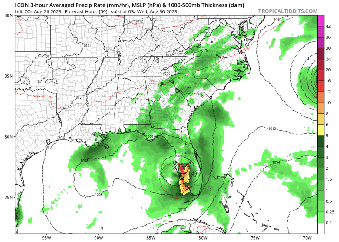
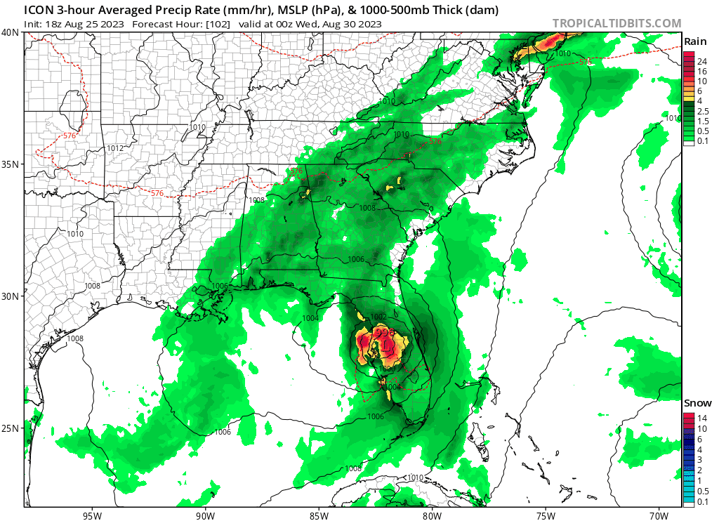
00z Icon… Decent S shift in near Ft Myers.
0 likes
Hurricane Eye Experience: David 79, Irene 99, Frances 04, Jeanne 04, Wilma 05… Hurricane Brush Experience: Andrew 92, Erin 95, Floyd 99, Matthew 16, Irma 17, Ian 22, Nicole 22…
-
lsuhurricane
- Category 1
- Posts: 270
- Joined: Tue Aug 15, 2017 2:53 pm
Re: ATL: INVEST 93L - Models
0z GEFS is taking aim at the Central Gulf Coast. Not nearly as many members to the east of the Big Bend/Appalachicola area

Last edited by lsuhurricane on Fri Aug 25, 2023 11:44 pm, edited 1 time in total.
0 likes
Re: ATL: INVEST 93L - Models
jfk08c wrote:GFS is like the guy that shows up late to work and pretends like they know what's going on. Not trusting it until it gets its act together
GFS did the same thing with Ian a lot. Took it way way west for awhile.
0 likes


Who is online
Users browsing this forum: No registered users and 27 guests