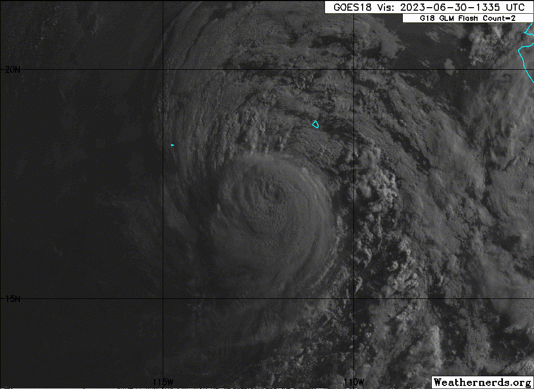
EPAC: ADRIAN - Post-Tropical - Discussion

Moderator: S2k Moderators

Message
Author
User avatar
aspen
Category 5
Category 5
Posts: 8057
Joined: Sat Oct 12, 2019 7:10 pm
Location: Connecticut, USA

Re: EPAC: ADRIAN - Hurricane - Discussion

#101 Postby aspen » Thu Jun 29, 2023 8:25 pm

Yellow Evan wrote:
EP, 01, 2023063000, , BEST, 0, 165N, 1110W, 80, 976, HU, 64, NEQ, 20, 15, 10, 15, 1008, 180, 15, 0, 0, E, 0, , 0, 0, ADRIAN, D, 0, , 0, 0, 0, 0, genesis-num, 004,


Given ADT and TAFB, this is likely a bit conservative.

Yeah looks more like a 2 to me. I’m surprised it got this strong. I expected it to be a broad and slow-to-consolidate system that would limp to marginal hurricane status.
0 likes   
Irene '11 Sandy '12 Hermine '16 5/15/2018 Derecho Fay '20 Isaias '20 Elsa '21 Henri '21 Ida '21

I am only a meteorology enthusiast who knows a decent amount about tropical cyclones. Look to the professional mets, the NHC, or your local weather office for the best information.

User avatar
cycloneye
Admin
Admin
Posts: 139329
Age: 67
Joined: Thu Oct 10, 2002 10:54 am
Location: San Juan, Puerto Rico

Re: EPAC: ADRIAN - Hurricane - Discussion

#102 Postby cycloneye » Thu Jun 29, 2023 9:34 pm

BULLETIN
Hurricane Adrian Advisory Number 10
NWS National Hurricane Center Miami FL EP012023
900 PM MDT Thu Jun 29 2023

...ADRIAN STRENGTHS SLIGHTLY WHILE MOVING NORTHWESTWARD...


SUMMARY OF 900 PM MDT...0300 UTC...INFORMATION
----------------------------------------------
LOCATION...16.7N 111.3W
ABOUT 440 MI...705 KM SSW OF THE SOUTHERN TIP OF BAJA CALIFORNIA
MAXIMUM SUSTAINED WINDS...90 MPH...150 KM/H
PRESENT MOVEMENT...NW OR 305 DEGREES AT 8 MPH...13 KM/H
MINIMUM CENTRAL PRESSURE...976 MB...28.82 INCHES


Hurricane Adrian Discussion Number 10
NWS National Hurricane Center Miami FL EP012023
900 PM MDT Thu Jun 29 2023

After a brief hiatus, Adrian appears to once again be strengthening
this evening. An SSMI/S satellite pass at 2239 UTC showed an
apparent dry air intrusion reaching the hurricane's core with a
weakness in the convection to the north. However, recent
geostationary infrared imagery suggests the storm has recovered and
an eye has emerged. Subjective Dvorak estimates from SAB and TAFB
were T5.0/90 kt and T4.5/77 kt, respectively. Therefore, the
initial intensity has been increased to 80 kt to represent a blend
of these estimates.

Adrian has a short window of conducive environmental and oceanic
conditions that could lead to some additional intensification.
Beginning in about 12 h or so, easterly deep-layer wind shear is
expected to increase while sea-surface temperatures along the
forecast track cool. These conditions should induce a weakening
trend. The NHC intensity prediction is above the all of the model
guidance in the short-term forecast, but follows the consensus aids
beyond 24 h. Adrian is still expected to become a post-tropical
remnant low by day 3.

The initial motion of the hurricane is estimated to be northwestward
or 305/7 kt. The storm is still expected to move generally
west-northwestward during the next few days around a ridge to its
northeast. The weaker, shallower vortex is then forecast to turn
westward in the low-level trade winds. As mentioned in previous
advisories, the track forecast for Adrian has been shifting to the
right and it has done so again for this cycle. The latest official
forecast is closest to the simple consensus aid, TVCE.


FORECAST POSITIONS AND MAX WINDS

INIT 30/0300Z 16.7N 111.3W 80 KT 90 MPH
12H 30/1200Z 17.1N 112.3W 85 KT 100 MPH
24H 01/0000Z 17.6N 113.5W 75 KT 85 MPH
36H 01/1200Z 18.0N 114.6W 60 KT 70 MPH
48H 02/0000Z 18.5N 115.8W 50 KT 60 MPH
60H 02/1200Z 18.7N 116.7W 40 KT 45 MPH
72H 03/0000Z 18.7N 117.6W 30 KT 35 MPH...POST-TROP/REMNT LOW
96H 04/0000Z 18.7N 118.9W 20 KT 25 MPH...POST-TROP/REMNT LOW
120H 05/0000Z 18.6N 120.5W 20 KT 25 MPH...POST-TROP/REMNT LOW

$$
Forecaster Bucci
0 likes   
Visit the Caribbean-Central America Weather Thread where you can find at first post web cams,radars
and observations from Caribbean basin members Click Here

Sciencerocks
Category 5
Category 5
Posts: 7287
Age: 38
Joined: Thu Jul 06, 2017 1:51 am

Re: EPAC: ADRIAN - Hurricane - Discussion

#103 Postby Sciencerocks » Thu Jun 29, 2023 9:51 pm

Image
0 likes   

User avatar
Kingarabian
S2K Supporter
S2K Supporter
Posts: 15451
Joined: Sat Aug 08, 2009 3:06 am
Location: Honolulu, Hawaii

Re: EPAC: ADRIAN - Hurricane - Discussion

#104 Postby Kingarabian » Fri Jun 30, 2023 3:21 am

Convection quickly warming and its size is shrinking despite the fact its still near 27C waters.
0 likes   
RIP Kobe Bryant

User avatar
cycloneye
Admin
Admin
Posts: 139329
Age: 67
Joined: Thu Oct 10, 2002 10:54 am
Location: San Juan, Puerto Rico

Re: EPAC: ADRIAN - Hurricane - Discussion

#105 Postby cycloneye » Fri Jun 30, 2023 3:48 am

Hurricane Adrian Discussion Number 11
NWS National Hurricane Center Miami FL EP012023
300 AM MDT Fri Jun 30 2023

Until the last hour or so, Adrian had been maintaining a healthy
structure overnight. Its eye, which became more distinct around the
time of the prior advisory, has mostly remained intact, with a
convective ring of -65 to -70 C cold temperatures encircling it on
IR satellite. While there have not been any recent microwave
imagery, the earlier passes suggested Adrian's inner core had
contracted some, which is supported by overnight ASCAT data which
showed the wind radii had also contracted from yesterday. 0600 UTC
subjective Dvorak intensity estimates from TAFB were T5.0/90 kt and
T4.5/77 kt from SAB. Meanwhile, objective intensity estimates from
ADT and SATCON have been hovering around 90 kt, with the
experimental D-MINT and D-PRINT intensity estimates from UW-CIMSS a
bit under those values. The initial intensity this advisory will be
set at 85-kt as a compromise of the available subjective and
objective data, though recent satellite imagery has become more
ragged, suggesting Adrian is near its peak intensity.

Adrian's initial motion has bent a little more west-northwestward at
300/6 kt. This general west-northwestward motion is expected to
continue under the dominating influence of a mid-level ridge
centered to its north. However, as Adrian weakens, its steering will
become more influenced by the low-level trade wind flow which should
result in a gradual turn westward. The latest track guidance has not
changed much from the previous cycle and the NHC track continues to
lie near the reliable consensus aids HCCA and TVCE.

While I cannot preclude the possibility that Adrian intensifies a
little more in the short-term, it is more likely the hurricane is
near peak intensity given the recent satellite trends. Easterly
shear is also expected to gradually increase while the system
crosses the 26-C sea-surface temperature isotherm in about 24 hours.
A combination of these factors should ultimately induce a weakening
trend, and the latest NHC intensity guidance shows a faster rate of
weakening between 24-48 hours. Both the global and regional
hurricane models suggest Adrian will become devoid of convection
shortly thereafter, with the latest forecast now showing the system
becoming a post-tropical remnant low by 60 hours.


FORECAST POSITIONS AND MAX WINDS

INIT 30/0900Z 16.7N 111.8W 85 KT 100 MPH
12H 30/1800Z 17.1N 112.7W 80 KT 90 MPH
24H 01/0600Z 17.6N 113.9W 70 KT 80 MPH
36H 01/1800Z 18.1N 115.0W 55 KT 65 MPH
48H 02/0600Z 18.5N 115.9W 40 KT 45 MPH
60H 02/1800Z 18.7N 116.9W 30 KT 35 MPH...POST-TROP/REMNT LOW
72H 03/0600Z 18.8N 117.8W 25 KT 30 MPH...POST-TROP/REMNT LOW
96H 04/0600Z 18.7N 119.3W 20 KT 25 MPH...POST-TROP/REMNT LOW
120H 05/0600Z...DISSIPATED

$$
Forecaster Papin
0 likes   
Visit the Caribbean-Central America Weather Thread where you can find at first post web cams,radars
and observations from Caribbean basin members Click Here

User avatar
Yellow Evan
Professional-Met
Professional-Met
Posts: 15956
Age: 25
Joined: Fri Jul 15, 2011 12:48 pm
Location: Henderson, Nevada/Honolulu, HI
Contact:

Re: EPAC: ADRIAN - Hurricane - Discussion

#106 Postby Yellow Evan » Fri Jun 30, 2023 4:04 am

Kingarabian wrote:Convection quickly warming and its size is shrinking despite the fact its still near 27C waters.


Dry air has sort of been a constant thorn by its side. Only really looked good at 0z when it was able to consistently avoid it.
0 likes   

User avatar
Yellow Evan
Professional-Met
Professional-Met
Posts: 15956
Age: 25
Joined: Fri Jul 15, 2011 12:48 pm
Location: Henderson, Nevada/Honolulu, HI
Contact:

Re: EPAC: ADRIAN - Hurricane - Discussion

#107 Postby Yellow Evan » Fri Jun 30, 2023 4:07 am

Glad Papin upgraded because Bucci saying 77 and 90 (the 77 from SAB was a clear incorrect fix anyway) averaged to 80 did not compute.
2 likes   

User avatar
Yellow Evan
Professional-Met
Professional-Met
Posts: 15956
Age: 25
Joined: Fri Jul 15, 2011 12:48 pm
Location: Henderson, Nevada/Honolulu, HI
Contact:

Re: EPAC: ADRIAN - Hurricane - Discussion

#108 Postby Yellow Evan » Fri Jun 30, 2023 4:31 am

Image

Latest frame that you could probably argue is representative of peak intensity.
0 likes   

Sciencerocks
Category 5
Category 5
Posts: 7287
Age: 38
Joined: Thu Jul 06, 2017 1:51 am

Re: EPAC: ADRIAN - Hurricane - Discussion

#109 Postby Sciencerocks » Fri Jun 30, 2023 6:06 am

Image
0 likes   

User avatar
Yellow Evan
Professional-Met
Professional-Met
Posts: 15956
Age: 25
Joined: Fri Jul 15, 2011 12:48 pm
Location: Henderson, Nevada/Honolulu, HI
Contact:

Re: EPAC: ADRIAN - Hurricane - Discussion

#110 Postby Yellow Evan » Fri Jun 30, 2023 6:15 am

Image

One last run at T5.0.
0 likes   

User avatar
Yellow Evan
Professional-Met
Professional-Met
Posts: 15956
Age: 25
Joined: Fri Jul 15, 2011 12:48 pm
Location: Henderson, Nevada/Honolulu, HI
Contact:

Re: EPAC: ADRIAN - Hurricane - Discussion

#111 Postby Yellow Evan » Fri Jun 30, 2023 7:28 am

TXPZ24 KNES 301222
TCSENP

A. 01E (ADRIAN)

B. 30/1200Z

C. 17.1N

D. 111.9W

E. ONE/GOES-W

F. T4.5/4.5

G. IR/EIR/SWIR

H. REMARKS...OW EYE SURROUNDED BY A LG RING AND EMBEDDED IN MG YIELDS
A DT OF 4.5. THE MET IS 5.5. THE PT IS 5.0. THE FT IS BASED ON THE DT.

I. ADDL POSITIONS

NIL


...GATLING
0 likes   

User avatar
Yellow Evan
Professional-Met
Professional-Met
Posts: 15956
Age: 25
Joined: Fri Jul 15, 2011 12:48 pm
Location: Henderson, Nevada/Honolulu, HI
Contact:

Re: EPAC: ADRIAN - Hurricane - Discussion

#112 Postby Yellow Evan » Fri Jun 30, 2023 7:30 am

Image

T5.5 now with B surrounded and LG embedded.
0 likes   

User avatar
Yellow Evan
Professional-Met
Professional-Met
Posts: 15956
Age: 25
Joined: Fri Jul 15, 2011 12:48 pm
Location: Henderson, Nevada/Honolulu, HI
Contact:

Re: EPAC: ADRIAN - Hurricane - Discussion

#113 Postby Yellow Evan » Fri Jun 30, 2023 8:37 am

EP, 01, 202306301200, 10, DVTS, CI, , 1710N, 11190W, , 1, 102, 2, 960, 2, DVRK, , , , , , , , , , , , , , E, TAFB, AL, I, 1, 5555 /////, , , GOES18, CSC, T,
0 likes   

User avatar
Kingarabian
S2K Supporter
S2K Supporter
Posts: 15451
Joined: Sat Aug 08, 2009 3:06 am
Location: Honolulu, Hawaii

Re: EPAC: ADRIAN - Hurricane - Discussion

#114 Postby Kingarabian » Fri Jun 30, 2023 9:08 am

Almost a major hurricane lol.

ADT isn't fixing the eye correctly so it's keeping the CI down. Might bring down the average and keep the NHC from classifying this a major.
0 likes   
RIP Kobe Bryant

User avatar
cycloneye
Admin
Admin
Posts: 139329
Age: 67
Joined: Thu Oct 10, 2002 10:54 am
Location: San Juan, Puerto Rico

Re: EPAC: ADRIAN - Hurricane - Discussion

#115 Postby cycloneye » Fri Jun 30, 2023 9:52 am

BULLETIN
Hurricane Adrian Advisory Number 12
NWS National Hurricane Center Miami FL EP012023
900 AM MDT Fri Jun 30 2023

...ADRIAN SLIGHTLY STRONGER...


SUMMARY OF 900 AM MDT...1500 UTC...INFORMATION
----------------------------------------------
LOCATION...17.3N 112.2W
ABOUT 415 MI...665 KM SSW OF THE SOUTHERN TIP OF BAJA CALIFORNIA
MAXIMUM SUSTAINED WINDS...105 MPH...165 KM/H
PRESENT MOVEMENT...NW OR 305 DEGREES AT 7 MPH...11 KM/H
MINIMUM CENTRAL PRESSURE...970 MB...28.65 INCHES


Hurricane Adrian Discussion Number 12
NWS National Hurricane Center Miami FL EP012023
900 AM MDT Fri Jun 30 2023

The overall satellite presentation of Adrian has improved this
morning. The eye is embedded deeper within a more symmetric central
dense overcast and surrounded by a ring of deep convection with
infrared cloud top temperatures colder than -60 deg C. Recent SSMIS
microwave images reveal a well-defined mid-level eyewall, although
some vertical tilt is noted between the 91 GHz and 37 GHz channels,
which suggests Adrian may be experiencing some easterly shear. The
initial intensity is a bit more uncertain than normal given the
large spread in the satellite intensity estimates, which range from
77-102 kt. Based on the improved satellite structure, the initial
intensity is raised to 90 kt for this advisory. This lies in between
the subjective SAB and TAFB Dvorak estimates, and is in best
agreement with recent UW-CIMSS ADT and AiDT estimates.

The hurricane is forecast to cross the 26 deg C SST isotherm and
encounter increased easterly shear during the next 12 to 24 h.
Therefore, the official NHC forecast shows gradual weakening in the
near term, followed by more rapid weakening as the cyclone becomes
increasingly sheared and moves over even cooler waters. Adrian will
likely struggle to produce organized convection beyond 48 h given
these hostile conditions, and it is forecast to degenerate to a
remnant low shortly thereafter and dissipate by early Wednesday.

Adrian has recently been moving more northwestward, and its initial
motion is 305/6 kt. The cyclone is forecast to move generally
west-northwestward during the next couple of days, around the
southwestern periphery of mid-tropospheric high pressure centered
over the southern United States. As Adrian loses deep convection and
becomes more vertically shallow, the remnant low is expected to turn
more westward on Monday within the low-level trade wind flow. Once
again, the center of Adrian and the latest track guidance has
trended to the right of the previous forecast, and so the updated
NHC forecast has been adjusted in that direction.


FORECAST POSITIONS AND MAX WINDS

INIT 30/1500Z 17.3N 112.2W 90 KT 105 MPH
12H 01/0000Z 17.7N 113.1W 80 KT 90 MPH
24H 01/1200Z 18.2N 114.3W 65 KT 75 MPH
36H 02/0000Z 18.6N 115.3W 50 KT 60 MPH
48H 02/1200Z 19.0N 116.3W 35 KT 40 MPH
60H 03/0000Z 19.2N 117.1W 30 KT 35 MPH...POST-TROP/REMNT LOW
72H 03/1200Z 19.4N 118.2W 25 KT 30 MPH...POST-TROP/REMNT LOW
96H 04/1200Z 19.4N 119.6W 20 KT 25 MPH...POST-TROP/REMNT LOW
120H 05/1200Z...DISSIPATED

$$
Forecaster Reinhart
0 likes   
Visit the Caribbean-Central America Weather Thread where you can find at first post web cams,radars
and observations from Caribbean basin members Click Here

User avatar
Hurricane2022
Category 4
Category 4
Posts: 945
Joined: Tue Aug 23, 2022 11:38 pm
Location: Araçatuba, Brazil

Re: EPAC: ADRIAN - Hurricane - Discussion

#116 Postby Hurricane2022 » Fri Jun 30, 2023 10:18 am

Image
I think this is a Major Hurricane.
0 likes   
Sorry for the bad English sometimes...!
For reliable and detailed information for any meteorological phenomenon, please consult the National Hurricane Center, Joint Typhoon Warning Center , or your local Meteo Center.

--------

Una cvm Christo, pro Christo, et in Christo. Sit nomen Domini benedictvm.

User avatar
Yellow Evan
Professional-Met
Professional-Met
Posts: 15956
Age: 25
Joined: Fri Jul 15, 2011 12:48 pm
Location: Henderson, Nevada/Honolulu, HI
Contact:

Re: EPAC: ADRIAN - Hurricane - Discussion

#117 Postby Yellow Evan » Fri Jun 30, 2023 10:23 am

Image

Clear surrounded W. Probably at peak now with DMin and sub-26C SSTs incoming.
0 likes   

User avatar
Yellow Evan
Professional-Met
Professional-Met
Posts: 15956
Age: 25
Joined: Fri Jul 15, 2011 12:48 pm
Location: Henderson, Nevada/Honolulu, HI
Contact:

Re: EPAC: ADRIAN - Hurricane - Discussion

#118 Postby Yellow Evan » Fri Jun 30, 2023 10:27 am

Kingarabian wrote:Almost a major hurricane lol.

ADT isn't fixing the eye correctly so it's keeping the CI down. Might bring down the average and keep the NHC from classifying this a major.


This storm is too small for ADT’s cloud top calculations to be particularly effective much like Felicia and Darby. ADT calculates cloud tops using an 80 km ring IIRC and the CDO is smaller than that.
2 likes   

User avatar
Yellow Evan
Professional-Met
Professional-Met
Posts: 15956
Age: 25
Joined: Fri Jul 15, 2011 12:48 pm
Location: Henderson, Nevada/Honolulu, HI
Contact:

Re: EPAC: ADRIAN - Hurricane - Discussion

#119 Postby Yellow Evan » Fri Jun 30, 2023 11:48 am

Image

Axissymmetrization.
0 likes   

Sciencerocks
Category 5
Category 5
Posts: 7287
Age: 38
Joined: Thu Jul 06, 2017 1:51 am

Re: EPAC: ADRIAN - Hurricane - Discussion

#120 Postby Sciencerocks » Fri Jun 30, 2023 12:05 pm

Image
0 likes   


Return to “2023”

Who is online

Users browsing this forum: No registered users and 16 guests