ATL: NICOLE - Models
Moderator: S2k Moderators
-
gatorcane

- S2K Supporter

- Posts: 23499
- Age: 46
- Joined: Sun Mar 13, 2005 3:54 pm
- Location: Boca Raton, FL
Re: ATL: INVEST 98L - Models
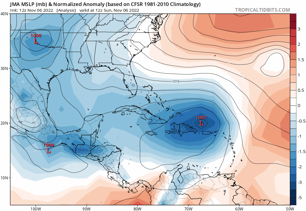
JMA recurves after swiping Florida’s east coast. Yesterday it was through Florida.
1 likes
-
Blown Away

- S2K Supporter
- Posts: 9867
- Joined: Wed May 26, 2004 6:17 am
Re: ATL: INVEST 98L - Models
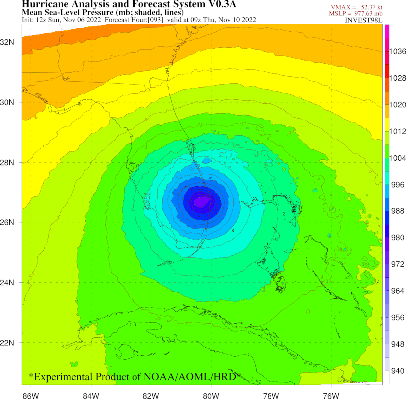
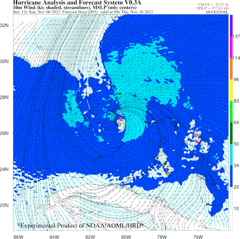
Jr0d wrote:Based on the GFS, this does not become fully tropical until Wednesday morning, showing the 'core' separate from the rest of the system based on their simulated IR satellite. The CMC's simulated IR does not look tropical until Thursday. Both show an eye forming.
In my opinion, if this can become fully tropical, it will have a window to strengthen to a hurricane.
I do think the SW dive that all the modems are picking up on is a big factor, the further south it goes the stronger this can get.
Yes, seems all the models start wrapping around center after @48 hours. Also, 98L is intensifying as it approaches land, which has been the theme all season.
1 likes
Hurricane Eye Experience: David 79, Irene 99, Frances 04, Jeanne 04, Wilma 05... EYE COMING MY WAY IN 2024…
Hurricane Brush Experience: Andrew 92, Erin 95, Floyd 99, Matthew 16, Irma 17, Ian 22, Nicole 22…
Hurricane Brush Experience: Andrew 92, Erin 95, Floyd 99, Matthew 16, Irma 17, Ian 22, Nicole 22…
-
gatorcane
- S2K Supporter
- Posts: 23499
- Age: 46
- Joined: Sun Mar 13, 2005 3:54 pm
- Location: Boca Raton, FL
Re: ATL: INVEST 98L - Models
I suspect we will see models shift as we get closer to possible Florida landfall. Maybe those who are in the crosshairs now is a good thing. Could be more south or more, even missing Florida is on the table. We have seen countless times that even within sometimes 24 hours (day of) some shifts can happen and certainly within the timeframe we are in now.
6 likes
-
Blown Away
- S2K Supporter
- Posts: 9867
- Joined: Wed May 26, 2004 6:17 am
Re: ATL: INVEST 98L - Models
gatorcane wrote:I suspect we will see models shift as we get closer to possible Florida landfall. Could be more south or more, even missing Florida is on the table. We have seen countless times that even within sometimes 24 hours some shifts and certainly within the timeframe we are in now.
How long does 98L take to make that turn will decide it. Any slight delay at this point could allow a FL miss.
GFS takes 98L into the GOM and we are within 4 day window, that would be a big miss for GFS if 98L misses FL. JMHO
0 likes
Hurricane Eye Experience: David 79, Irene 99, Frances 04, Jeanne 04, Wilma 05... EYE COMING MY WAY IN 2024…
Hurricane Brush Experience: Andrew 92, Erin 95, Floyd 99, Matthew 16, Irma 17, Ian 22, Nicole 22…
Hurricane Brush Experience: Andrew 92, Erin 95, Floyd 99, Matthew 16, Irma 17, Ian 22, Nicole 22…
-
Spacecoast

- Category 2

- Posts: 687
- Joined: Thu Aug 31, 2017 2:03 pm


Re: ATL: INVEST 98L - Models
Couple thoughts thus far. I'm not sure if this has been discussed thus far. Depending on the latitude & orientation of 500mb ridge when 98L's northward motion becomes blocked, I'm beginning to consider the possibility of a southwesterly track potentially cutting through or even south of the Key's.
I too think that this "Gale" will fail to develop a classic eye wall structure therefore limiting intensity to a high-end T.S. or minimal hurricane. That's not suggesting a diminished threat, but perhaps an even larger displaced max wind field a good deal farther north of center then normal. Finally, I'm thinking there may be a very significant precipitation gradient with lower top training that could really dump along a long stretch of coastline, but maybe lacking the deeper convection that Ian carried well inland and across the state.
I too think that this "Gale" will fail to develop a classic eye wall structure therefore limiting intensity to a high-end T.S. or minimal hurricane. That's not suggesting a diminished threat, but perhaps an even larger displaced max wind field a good deal farther north of center then normal. Finally, I'm thinking there may be a very significant precipitation gradient with lower top training that could really dump along a long stretch of coastline, but maybe lacking the deeper convection that Ian carried well inland and across the state.
4 likes
Personal Forecast Disclaimer:
The posts in this forum are NOT official forecast and should not be used as such. They are just the opinion of the poster and may or may not be backed by sound meteorological data. They are NOT endorsed by any professional institution or storm2k.org. For official information, please refer to the NHC and NWS products.
The posts in this forum are NOT official forecast and should not be used as such. They are just the opinion of the poster and may or may not be backed by sound meteorological data. They are NOT endorsed by any professional institution or storm2k.org. For official information, please refer to the NHC and NWS products.
Re: ATL: INVEST 98L - Models
gatorcane wrote:I suspect we will see models shift as we get closer to possible Florida landfall. Maybe those who are in the crosshairs now is a good thing. Could be more south or more, even missing Florida is on the table. We have seen countless times that even within sometimes 24 hours (day of) some shifts can happen and certainly within the timeframe we are in now.
1 likes
Personal Forecast Disclaimer:
The posts in this forum are NOT official forecast and should not be used as such. They are just the opinion of the poster and may or may not be backed by sound meteorological data. They are NOT endorsed by any professional institution or storm2k.org. For official information, please refer to the NHC and NWS products.
The posts in this forum are NOT official forecast and should not be used as such. They are just the opinion of the poster and may or may not be backed by sound meteorological data. They are NOT endorsed by any professional institution or storm2k.org. For official information, please refer to the NHC and NWS products.
Re: ATL: INVEST 98L - Models
Blown Away wrote:gatorcane wrote:I suspect we will see models shift as we get closer to possible Florida landfall. Could be more south or more, even missing Florida is on the table. We have seen countless times that even within sometimes 24 hours some shifts and certainly within the timeframe we are in now.
How long does 98L take to make that turn will decide it. Any slight delay at this point could allow a FL miss.
GFS takes 98L into the GOM and we are within 4 day window, that would be a big miss for GFS if 98L misses FL. JMHO
It would be a huge miss by the GFS within 4 days if 98L were to miss FL. But we know the GFS has had huge misses before. Remember that for Ian, it had it hit Destin within 4 days and Apalachee Bay within just 3 days. Although it is an awful model, I'll mention mainly for the record that the last 2 NAVGEM runs never quite make landfall anywhere in the US!
0 likes
Personal Forecast Disclaimer:
The posts in this forum are NOT official forecasts and should not be used as such. They are just the opinion of the poster and may or may not be backed by sound meteorological data. They are NOT endorsed by any professional institution or storm2k.org. For official information, please refer to the NHC and NWS products.
The posts in this forum are NOT official forecasts and should not be used as such. They are just the opinion of the poster and may or may not be backed by sound meteorological data. They are NOT endorsed by any professional institution or storm2k.org. For official information, please refer to the NHC and NWS products.
Re: ATL: INVEST 98L - Models
The 18Z ICON is east of the prior two runs and just west of the 0Z with only a skim of the central FL east coast and then only a little inland to just west of Jacksonville.
1 likes
Personal Forecast Disclaimer:
The posts in this forum are NOT official forecasts and should not be used as such. They are just the opinion of the poster and may or may not be backed by sound meteorological data. They are NOT endorsed by any professional institution or storm2k.org. For official information, please refer to the NHC and NWS products.
The posts in this forum are NOT official forecasts and should not be used as such. They are just the opinion of the poster and may or may not be backed by sound meteorological data. They are NOT endorsed by any professional institution or storm2k.org. For official information, please refer to the NHC and NWS products.
Re: ATL: INVEST 98L - Models
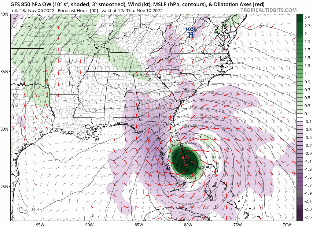
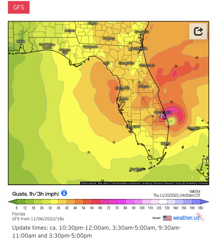
18Z GFS: Stuart cat 2 7AM Thu
Landfall time and location very similar to 12Z Euro, UKMET, JMA
Landfall time and location very similar to 12Z Euro, UKMET, JMA
Last edited by LarryWx on Sun Nov 06, 2022 5:06 pm, edited 1 time in total.
0 likes
Personal Forecast Disclaimer:
The posts in this forum are NOT official forecasts and should not be used as such. They are just the opinion of the poster and may or may not be backed by sound meteorological data. They are NOT endorsed by any professional institution or storm2k.org. For official information, please refer to the NHC and NWS products.
The posts in this forum are NOT official forecasts and should not be used as such. They are just the opinion of the poster and may or may not be backed by sound meteorological data. They are NOT endorsed by any professional institution or storm2k.org. For official information, please refer to the NHC and NWS products.
-
cycloneye

- Admin

- Posts: 139314
- Age: 67
- Joined: Thu Oct 10, 2002 10:54 am
- Location: San Juan, Puerto Rico
Re: ATL: INVEST 98L - Models
12z new experimental model HAFS v0.3S.

0 likes
Visit the Caribbean-Central America Weather Thread where you can find at first post web cams,radars
and observations from Caribbean basin members Click Here
and observations from Caribbean basin members Click Here
-
SFLcane

- S2K Supporter
- Posts: 9617
- Age: 46
- Joined: Sat Jun 05, 2010 1:44 pm
- Location: Lake Worth Florida
Re: ATL: INVEST 98L - Models
LarryWx wrote:18Z GFS: Stuart cat 2 7AM Thu
Landfall time and location very similar to 12Z Euro, UKMET
Na more like west Palm. Right over my house
Last edited by SFLcane on Sun Nov 06, 2022 5:22 pm, edited 1 time in total.
0 likes
-
AutoPenalti
- Category 5

- Posts: 3949
- Age: 27
- Joined: Mon Aug 17, 2015 4:16 pm
- Location: Ft. Lauderdale, Florida
Re: ATL: INVEST 98L - Models
Wouldn’t be surprised to see this OTS in consecutive runs.
0 likes
The posts in this forum are NOT official forecasts and should not be used as such. They are just the opinion of the poster and may or may not be backed by sound meteorological data. They are NOT endorsed by any professional institution or STORM2K. For official information, please refer to products from the NHC and NWS.
Model Runs Cheat Sheet:
GFS (5:30 AM/PM, 11:30 AM/PM)
HWRF, GFDL, UKMET, NAVGEM (6:30-8:00 AM/PM, 12:30-2:00 AM/PM)
ECMWF (1:45 AM/PM)
TCVN is a weighted averaged
Re: ATL: INVEST 98L - Models
SFLcane wrote:LarryWx wrote:18Z GFS: Stuart cat 2 7AM Thu
Landfall time and location very similar to 12Z Euro, UKMET
Na more like west Palm. Right over my house
To get technical, I'll go with in between as Tidbits has it at 27.0N vs WPB's 26.7 and Stuart's 27.2.
0 likes
Personal Forecast Disclaimer:
The posts in this forum are NOT official forecasts and should not be used as such. They are just the opinion of the poster and may or may not be backed by sound meteorological data. They are NOT endorsed by any professional institution or storm2k.org. For official information, please refer to the NHC and NWS products.
The posts in this forum are NOT official forecasts and should not be used as such. They are just the opinion of the poster and may or may not be backed by sound meteorological data. They are NOT endorsed by any professional institution or storm2k.org. For official information, please refer to the NHC and NWS products.
-
Blown Away
- S2K Supporter
- Posts: 9867
- Joined: Wed May 26, 2004 6:17 am
Re: ATL: INVEST 98L - Models
LarryWx wrote:SFLcane wrote:LarryWx wrote:18Z GFS: Stuart cat 2 7AM Thu
Landfall time and location very similar to 12Z Euro, UKMET
Na more like west Palm. Right over my house
To get technical, I'll go with in between as Tidbits has it at 27.0N vs WPB's 26.7 and Stuart's 27.2.
Jupiter to Hobe Sound, @15 miles S of Stuart.
1 likes
Hurricane Eye Experience: David 79, Irene 99, Frances 04, Jeanne 04, Wilma 05... EYE COMING MY WAY IN 2024…
Hurricane Brush Experience: Andrew 92, Erin 95, Floyd 99, Matthew 16, Irma 17, Ian 22, Nicole 22…
Hurricane Brush Experience: Andrew 92, Erin 95, Floyd 99, Matthew 16, Irma 17, Ian 22, Nicole 22…
-
jlauderdal
- S2K Supporter
- Posts: 6776
- Joined: Wed May 19, 2004 5:46 am
- Location: NE Fort Lauderdale
- Contact:
Re: RE: Re: ATL: INVEST 98L - Models
There is text output for the coordinates if you want to get get in the weedsLarryWx wrote:SFLcane wrote:LarryWx wrote:18Z GFS: Stuart cat 2 7AM Thu
Landfall time and location very similar to 12Z Euro, UKMET
Na more like west Palm. Right over my house
To get technical, I'll go with in between as Tidbits has it at 27.0N vs WPB's 26.7 and Stuart's 27.2.
0 likes

Re: ATL: INVEST 98L - Models
SFLcane wrote:LarryWx wrote:18Z GFS: Stuart cat 2 7AM Thu
Landfall time and location very similar to 12Z Euro, UKMET
Na more like west Palm. Right over my house
https://i.postimg.cc/zfngn1y4/AC336-BA3-64-DF-4-D01-A1-E4-5794-BC2-DEB2-E.gif
We live in the same basic area, I'm at 26.6N
If we are near the center, we will probably escape the worst of it.
Being North and Northeast of this one is where it appears the worst will occur.
Wxman57 continues to be bearish about this system.
Local Met this morning was pointing out that the way it looks to be shaped, just west of the center might be sunny.
We'll see, climatology gets thrown out here and it is usually my default (and I'm usually right because of that, lol)
0 likes
Personal Forecast Disclaimer:
My posts are just my opinion and are most likely not backed by sound meteorological data. They are NOT endorsed by any professional institution or storm2k.org. For official information, please refer to the NHC and NWS products.
Bottom line is that I am just expressing my opinion!!!
My posts are just my opinion and are most likely not backed by sound meteorological data. They are NOT endorsed by any professional institution or storm2k.org. For official information, please refer to the NHC and NWS products.
Bottom line is that I am just expressing my opinion!!!

Re: ATL: INVEST 98L - Models
AutoPenalti wrote:Wouldn’t be surprised to see this OTS in consecutive runs.
Technically I'm not surprised, but at a similar time frame Ian's forecast track kept moving west into the GOM, and we all know how that turned out.
0 likes
Who is online
Users browsing this forum: No registered users and 21 guests