ATL: NICOLE - Post-Tropical - Discussion

Moderator: S2k Moderators

Message
Author
hurricaneCW
Category 5
Category 5
Posts: 1773
Joined: Wed Mar 03, 2010 6:20 am
Location: Toms River, NJ

Re: ATL: INVEST 98L - Discussion

#41 Postby hurricaneCW » Sun Nov 06, 2022 9:37 am

ObsessedMiami wrote:The timing for Election Day is most interesting for planners. If shelters have to open, many would be acting as polling places only 24 hours before the event. Plus any delays in recounting. Ooofff bad timing, Just another Emergency Planner headache for a November storm


Impacts would be well after election day and planning would only come into play if the stronger solutions are correct. Euro is still not very enthused
0 likes   

User avatar
robbielyn
Category 5
Category 5
Posts: 1239
Joined: Wed May 07, 2003 9:45 am
Location: brooksville, fl

Re: ATL: INVEST 98L - Discussion

#42 Postby robbielyn » Sun Nov 06, 2022 9:43 am

hurricaneCW wrote:
ObsessedMiami wrote:The timing for Election Day is most interesting for planners. If shelters have to open, many would be acting as polling places only 24 hours before the event. Plus any delays in recounting. Ooofff bad timing, Just another Emergency Planner headache for a November storm


Impacts would be well after election day and planning would only come into play if the stronger solutions are correct. Euro is still not very enthused
Last edited by robbielyn on Sun Nov 06, 2022 9:53 am, edited 1 time in total.
0 likes   
Robbielyn McCrary
I know just about enough to sound like I know what I'm talking about sometimes. But for your safety please follow the nhc for truly professional forecasting. :D

User avatar
CronkPSU
S2K Supporter
S2K Supporter
Posts: 1900
Joined: Sun Aug 07, 2005 10:44 pm
Location: Avalon Park, FL

Re: ATL: INVEST 98L - Discussion

#43 Postby CronkPSU » Sun Nov 06, 2022 9:52 am

hurricaneCW wrote:
ObsessedMiami wrote:The timing for Election Day is most interesting for planners. If shelters have to open, many would be acting as polling places only 24 hours before the event. Plus any delays in recounting. Ooofff bad timing, Just another Emergency Planner headache for a November storm


Impacts would be well after election day and planning would only come into play if the stronger solutions are correct. Euro is still not very enthused


not for Florida...we will start feeling effects of this election night, and people need to start prepping Monday and Tuesday
1 likes   
Just like Jon Snow..."I know nothing" except what I know, and most of what I know is gathered by the fine people of the NHC

Sciencerocks
Category 5
Category 5
Posts: 7294
Age: 38
Joined: Thu Jul 06, 2017 1:51 am

Re: ATL: INVEST 98L - Discussion

#44 Postby Sciencerocks » Sun Nov 06, 2022 9:57 am

Image
0 likes   

User avatar
blp
Category 5
Category 5
Posts: 2807
Age: 45
Joined: Thu Sep 09, 2004 7:51 pm
Location: Miami, FL
Contact:

Re: ATL: INVEST 98L - Discussion

#45 Postby blp » Sun Nov 06, 2022 9:57 am

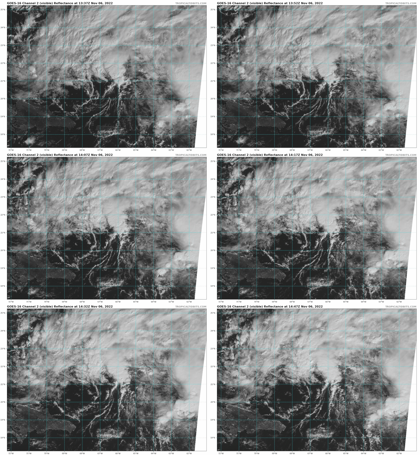
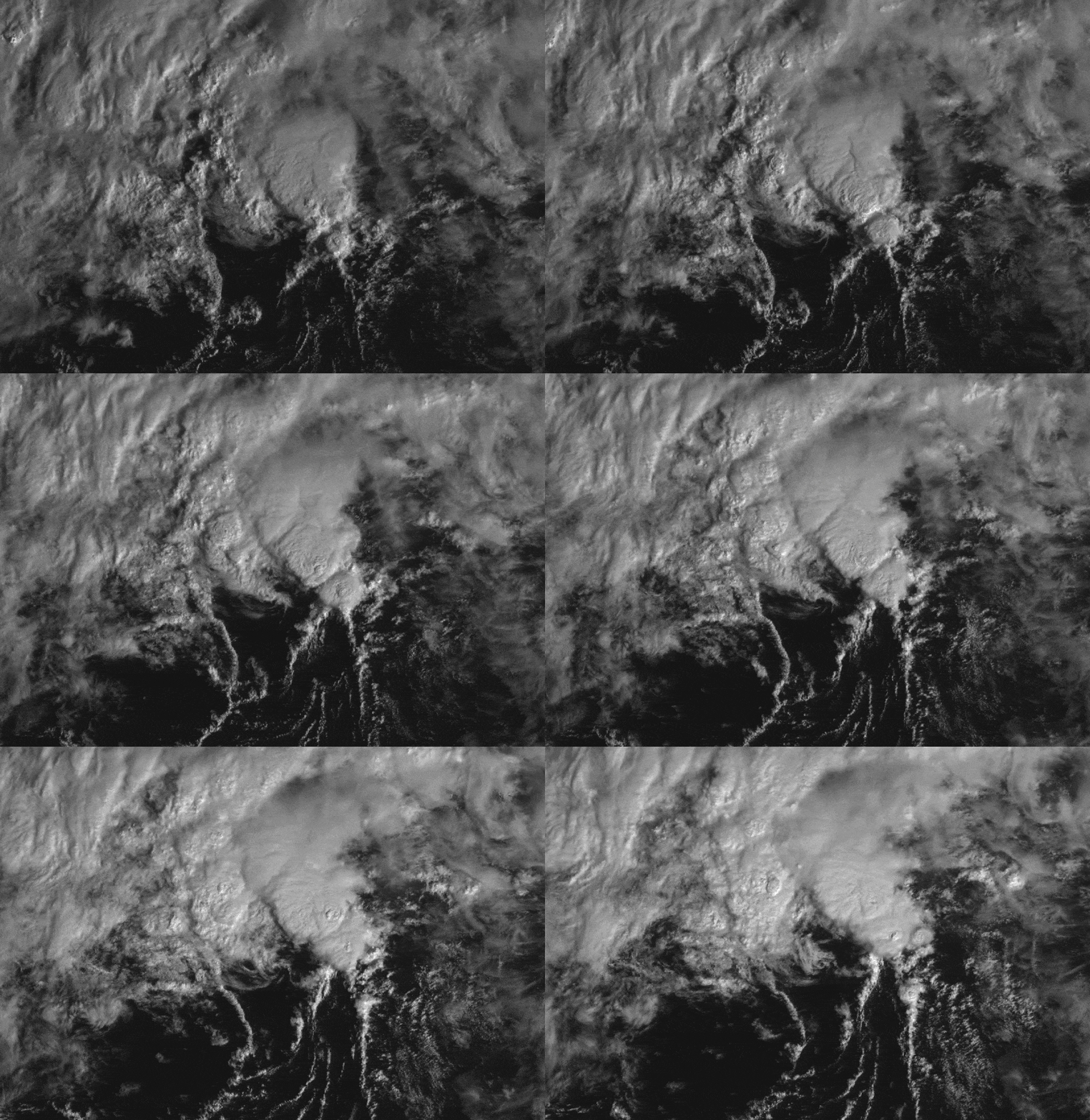
Interesting swirl.

Image
0 likes   
The following post is NOT an official forecast and should not be used as such. It is just the opinion of the poster and may or may not be backed by sound meteorological data. It is NOT endorsed by any professional institution including storm2k.org For Official Information please refer to the NHC and NWS products.

User avatar
GCANE
S2K Supporter
S2K Supporter
Posts: 10787
Joined: Mon Oct 22, 2007 8:03 am

Re: ATL: INVEST 98L - Discussion

#46 Postby GCANE » Sun Nov 06, 2022 9:59 am

Looks like the swirl is shaking off an outflow boundary impinging on it from the west.
0 likes   

User avatar
Blown Away
S2K Supporter
S2K Supporter
Posts: 9870
Joined: Wed May 26, 2004 6:17 am

Re: ATL: INVEST 98L - Discussion

#47 Postby Blown Away » Sun Nov 06, 2022 10:01 am

Image

Coming together!

LLC seems to be pulling together quickly, wouldn’t surprise me if that W turn occurs a little sooner and we get away from the jump N then WSW. That may open the door to Keys to WPB. JMHO
0 likes   
Hurricane Eye Experience: David 79, Irene 99, Frances 04, Jeanne 04, Wilma 05... EYE COMING MY WAY IN 2024…
Hurricane Brush Experience: Andrew 92, Erin 95, Floyd 99, Matthew 16, Irma 17, Ian 22, Nicole 22…

User avatar
GCANE
S2K Supporter
S2K Supporter
Posts: 10787
Joined: Mon Oct 22, 2007 8:03 am

Re: ATL: INVEST 98L - Discussion

#48 Postby GCANE » Sun Nov 06, 2022 10:06 am

ML moist air now covering all of PR.
Dry slot continuing to erode quickly.
1 likes   

TheBigO
Tropical Low
Tropical Low
Posts: 27
Joined: Wed Sep 06, 2017 9:39 pm
Location: Orlando, FL metro

Re: ATL: INVEST 98L - Discussion

#49 Postby TheBigO » Sun Nov 06, 2022 10:10 am

Man, the last thing my county (Seminole) needs right now is a multi-day rain event. We’re still getting flash flood alerts daily due to the water still around from Ian.
1 likes   

LarryWx
Category 5
Category 5
Posts: 5755
Joined: Sun Sep 07, 2003 2:04 pm
Location: GA

Re: ATL: INVEST 98L - Discussion

#50 Postby LarryWx » Sun Nov 06, 2022 10:18 am

ObsessedMiami wrote:The timing for Election Day is most interesting for planners. If shelters have to open, many would be acting as polling places only 24 hours before the event. Plus any delays in recounting. Ooofff bad timing, Just another Emergency Planner headache for a November storm


As was mentioned earlier, there has never been a US election with an Atlantic tropical cyclone threatening a portion of the lower 48 so close to Election Day though PR did have to deal with flooding rainfall from TS Klaus in 1984 on Election Day:

https://en.m.wikipedia.org/wiki/Hurricane_Klaus_(1984)

Keep these in mind:
"A watch is issued when hurricane conditions are a possibility within 48 hours. A warning is issued when a hurricane is expected in an area within 36 hours."

Based on the possibility of hurricane conditions in parts of FL on Wednesday night, there could easily be not just a H watch but even a H warning already issued on Election Day for part of FL! A watch could be issued Monday night. The implications of this possibility as regards the upcoming election are totally unpredictable.
4 likes   
Personal Forecast Disclaimer:
The posts in this forum are NOT official forecasts and should not be used as such. They are just the opinion of the poster and may or may not be backed by sound meteorological data. They are NOT endorsed by any professional institution or storm2k.org. For official information, please refer to the NHC and NWS products.

User avatar
Gums
S2K Supporter
S2K Supporter
Posts: 149
Joined: Sun Oct 07, 2018 7:30 pm
Location: Niceville, FL

Re: ATL: INVEST 98L - Discussion

#51 Postby Gums » Sun Nov 06, 2022 10:18 am

Salute!

jez shows to go ya, huh?

We are now praying for a front, but NWS foecasts for next 5 days is no help for one of those knights in shining armor we have had in late fall storm events. Sheeesh....

Were here for 1985 Kate, about 50 miles west of landfall and it weakened a lot before striking. Our wind was nil. Mexico Beach is rebuilding big time and all the new building procedures are way better than 1985 and even many places that Michael wiped out 4 years ago. Was just there last Sunday and Monday. If Joe is right, this storm will coast near Palm Beach, then rake the coast on up to Carolinas. Praying he's right.

Gums sends...

P.S. Get those poptarts now! Add beer and an extra propane tank while at it.
Last edited by Gums on Sun Nov 06, 2022 10:21 am, edited 1 time in total.
1 likes   

User avatar
Blown Away
S2K Supporter
S2K Supporter
Posts: 9870
Joined: Wed May 26, 2004 6:17 am

Re: ATL: INVEST 98L - Discussion

#52 Postby Blown Away » Sun Nov 06, 2022 10:18 am

Very little coverage here in SFL, once the NHC Advisory begins SFL may be close to 3 day cone with hurricane landfall. If all the models are correct TS conditions begin Wednesday.

This will ramp up quickly! FL is tough, we will vote Tuesday, deal with hurricane Thursday, and back to normal with nice cool weather next week!
5 likes   
Hurricane Eye Experience: David 79, Irene 99, Frances 04, Jeanne 04, Wilma 05... EYE COMING MY WAY IN 2024…
Hurricane Brush Experience: Andrew 92, Erin 95, Floyd 99, Matthew 16, Irma 17, Ian 22, Nicole 22…

cane5
Tropical Storm
Tropical Storm
Posts: 249
Joined: Fri Jul 02, 2021 4:24 pm

Re: ATL: INVEST 98L - Discussion

#53 Postby cane5 » Sun Nov 06, 2022 10:34 am


What’s really eerie is this is where Andrew formed with a stubborn high pressure ridge holding it down. No not comparing it to Andrew at all but just where storms sometimes develop and how the the ridging plays such a big part. In fact a trough by Saturday is too late for S Fla but will kick it up North.
0 likes   

User avatar
Category5Kaiju
Category 5
Category 5
Posts: 3419
Age: 22
Joined: Thu Dec 24, 2020 12:45 pm
Location: Seattle

Re: ATL: INVEST 98L - Discussion

#54 Postby Category5Kaiju » Sun Nov 06, 2022 10:42 am

Image

28 C waters everywhere to the east of Florida, where this system is projected to go
0 likes   
Unless explicitly stated, all information covered in my posts is based on my opinions and observations. Please refer to a professional meteorologist or an accredited weather research agency otherwise, especially if serious decisions must be made in the event of a potentially life-threatening tropical storm or hurricane.

User avatar
GCANE
S2K Supporter
S2K Supporter
Posts: 10787
Joined: Mon Oct 22, 2007 8:03 am

Re: ATL: INVEST 98L - Discussion

#55 Postby GCANE » Sun Nov 06, 2022 10:43 am

IR Sat analysis just came in.
http://rammb-data.cira.colostate.edu/tc ... 2211061500

Will be interesting to see how NHC deals with it.
0 likes   

User avatar
MetroMike
Category 3
Category 3
Posts: 831
Joined: Sun Aug 29, 2004 8:13 pm
Location: Tampa Bay
Contact:

Re: ATL: INVEST 98L - Discussion

#56 Postby MetroMike » Sun Nov 06, 2022 10:48 am

LarryWx wrote:
ObsessedMiami wrote:The timing for Election Day is most interesting for planners. If shelters have to open, many would be acting as polling places only 24 hours before the event. Plus any delays in recounting. Ooofff bad timing, Just another Emergency Planner headache for a November storm


As was mentioned earlier, there has never been a US election with an Atlantic tropical cyclone threatening a portion of the lower 48 so close to Election Day though PR did have to deal with flooding rainfall from TS Klaus in 1984 on Election Day:

https://en.m.wikipedia.org/wiki/Hurricane_Klaus_(1984)

Keep these in mind:
"A watch is issued when hurricane conditions are a possibility within 48 hours. A warning is issued when a hurricane is expected in an area within 36 hours."

Based on the possibility of hurricane conditions in parts of FL on Wednesday night, there could easily be not just a H watch but even a H warning already issued on Election Day for part of FL! A watch could be issued Monday night. The implications of this possibility as regards the upcoming election are totally unpredictable.


Exactly I echo your thoughts on this. Seems there is apathy with regards to planning for a potential event in Florida and a failure to be proactive with any implications this may have on Election Day itself with prepping involved.
Could be planning to fail.
1 likes   

User avatar
Hypercane_Kyle
Category 5
Category 5
Posts: 2901
Joined: Sat Mar 07, 2015 7:58 pm
Location: Cape Canaveral, FL

Re: ATL: INVEST 98L - Discussion

#57 Postby Hypercane_Kyle » Sun Nov 06, 2022 10:49 am

Image
0 likes   
My posts are my own personal opinion, defer to the National Hurricane Center (NHC) and other NOAA products for decision making during hurricane season.

User avatar
GCANE
S2K Supporter
S2K Supporter
Posts: 10787
Joined: Mon Oct 22, 2007 8:03 am

Re: ATL: INVEST 98L - Discussion

#58 Postby GCANE » Sun Nov 06, 2022 10:49 am

Swirl is looking more symmetrical.
If a big tower fires off, I'll put money on NHC scrambling recon.
0 likes   

User avatar
Blown Away
S2K Supporter
S2K Supporter
Posts: 9870
Joined: Wed May 26, 2004 6:17 am

Re: ATL: INVEST 98L - Discussion

#59 Postby Blown Away » Sun Nov 06, 2022 10:50 am

GCANE wrote:IR Sat analysis just came in.
http://rammb-data.cira.colostate.edu/tc ... 2211061500

Will be interesting to see how NHC deals with it.


Am I reading that correctly? 1006 mb and TD level winds??
1 likes   
Hurricane Eye Experience: David 79, Irene 99, Frances 04, Jeanne 04, Wilma 05... EYE COMING MY WAY IN 2024…
Hurricane Brush Experience: Andrew 92, Erin 95, Floyd 99, Matthew 16, Irma 17, Ian 22, Nicole 22…

User avatar
GCANE
S2K Supporter
S2K Supporter
Posts: 10787
Joined: Mon Oct 22, 2007 8:03 am

Re: ATL: INVEST 98L - Discussion

#60 Postby GCANE » Sun Nov 06, 2022 10:57 am

Blown Away wrote:
GCANE wrote:IR Sat analysis just came in.
http://rammb-data.cira.colostate.edu/tc ... 2211061500

Will be interesting to see how NHC deals with it.


Am I reading that correctly? 1006 mb and TD level winds??


I think I saw some 35 knt barbs in there
0 likes   


Return to “2022”

Who is online

Users browsing this forum: No registered users and 8 guests