ATL: NICOLE - Models
Moderator: S2k Moderators
-
AdamFirst

- S2K Supporter

- Posts: 2490
- Age: 36
- Joined: Thu Aug 14, 2008 10:54 am
- Location: Port Saint Lucie, FL
Re: ATL: NICOLE - Models
Both 12z HWRF and HMON into the St. Lucie Inlet. Similar in intensity but HMON is about 6 hours ahead of the HWRF.
1 likes
Dolphins Marlins Canes Golden Panthers HEAT
Andrew 1992 - Irene 1999 - Frances 2004 - Jeanne 2004 - Wilma 2005 - Fay 2008 - Isaac 2012 - Matthew 2016 - Irma 2017 - Dorian 2019 - Ian 2022 - Nicole 2022 - Milton 2024
Andrew 1992 - Irene 1999 - Frances 2004 - Jeanne 2004 - Wilma 2005 - Fay 2008 - Isaac 2012 - Matthew 2016 - Irma 2017 - Dorian 2019 - Ian 2022 - Nicole 2022 - Milton 2024
-
DESTRUCTION5

- Category 5

- Posts: 4430
- Age: 44
- Joined: Wed Sep 03, 2003 11:25 am
- Location: Stuart, FL
Re: ATL: NICOLE - Models
AdamFirst wrote:Both 12z HWRF and HMON into the St. Lucie Inlet. Similar in intensity but HMON is about 6 hours ahead of the HWRF.
CMC, GFS, HWRF, HMON all agree on hurricane at landfall in the 75-90 range. From Palm beach to Vero as a spread. Euro still not 100% tropical as of 6z.
4 likes
GATOR NATION IS E V E R Y W H E R E !
-
Blown Away

- S2K Supporter
- Posts: 10253
- Joined: Wed May 26, 2004 6:17 am
Re: ATL: NICOLE - Models

12z Ukmet... N side of guidance, but all pretty close now...
1 likes
Hurricane Eye Experience: David 79, Irene 99, Frances 04, Jeanne 04, Wilma 05… Hurricane Brush Experience: Andrew 92, Erin 95, Floyd 99, Matthew 16, Irma 17, Ian 22, Nicole 22…
-
Blown Away
- S2K Supporter
- Posts: 10253
- Joined: Wed May 26, 2004 6:17 am
Re: ATL: NICOLE - Models

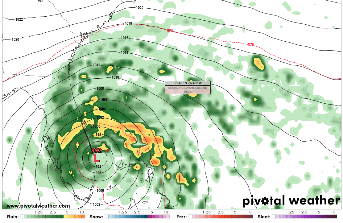
12z EURO... 24 hours, 1000 mb the lowest so far
1 likes
Hurricane Eye Experience: David 79, Irene 99, Frances 04, Jeanne 04, Wilma 05… Hurricane Brush Experience: Andrew 92, Erin 95, Floyd 99, Matthew 16, Irma 17, Ian 22, Nicole 22…
-
Blown Away
- S2K Supporter
- Posts: 10253
- Joined: Wed May 26, 2004 6:17 am
Re: ATL: NICOLE - Models

12z EURO... Coming in much stronger than previous runs... Looks more tropical...
1 likes
Hurricane Eye Experience: David 79, Irene 99, Frances 04, Jeanne 04, Wilma 05… Hurricane Brush Experience: Andrew 92, Erin 95, Floyd 99, Matthew 16, Irma 17, Ian 22, Nicole 22…
Re: ATL: NICOLE - Models
12Z Euro landfalls further north vs the 6Z
1 likes
Personal Forecast Disclaimer:
The posts in this forum are NOT official forecasts and should not be used as such. They are just the opinion of the poster and may or may not be backed by sound meteorological data. They are NOT endorsed by any professional institution or storm2k.org. For official information, please refer to the NHC and NWS products.
The posts in this forum are NOT official forecasts and should not be used as such. They are just the opinion of the poster and may or may not be backed by sound meteorological data. They are NOT endorsed by any professional institution or storm2k.org. For official information, please refer to the NHC and NWS products.
-
SFLcane

- S2K Supporter
- Posts: 10281
- Age: 48
- Joined: Sat Jun 05, 2010 1:44 pm
- Location: Lake Worth Florida
Re: ATL: NICOLE - Models
LarryWx wrote:12Z Euro landfalls further north vs the 6Z
About the same near PB.
1 likes
Re: ATL: NICOLE - Models
12Z Euro 72 is 50 miles NNW of Lake Okeechobee vs west of the Lake on the 6Z at 78
1 likes
Personal Forecast Disclaimer:
The posts in this forum are NOT official forecasts and should not be used as such. They are just the opinion of the poster and may or may not be backed by sound meteorological data. They are NOT endorsed by any professional institution or storm2k.org. For official information, please refer to the NHC and NWS products.
The posts in this forum are NOT official forecasts and should not be used as such. They are just the opinion of the poster and may or may not be backed by sound meteorological data. They are NOT endorsed by any professional institution or storm2k.org. For official information, please refer to the NHC and NWS products.
-
Blown Away
- S2K Supporter
- Posts: 10253
- Joined: Wed May 26, 2004 6:17 am
Re: ATL: NICOLE - Models

Landfall Jupiter.
1 likes
Hurricane Eye Experience: David 79, Irene 99, Frances 04, Jeanne 04, Wilma 05… Hurricane Brush Experience: Andrew 92, Erin 95, Floyd 99, Matthew 16, Irma 17, Ian 22, Nicole 22…
-
SFLcane
- S2K Supporter
- Posts: 10281
- Age: 48
- Joined: Sat Jun 05, 2010 1:44 pm
- Location: Lake Worth Florida
Re: ATL: NICOLE - Models
LarryWx wrote:12Z Euro 72 is 40 miles north of Lake Okeechobee vs west of the Lake on the 6Z at 78
lol 40 miles 20 miles this is not going to matter windfield will be huge.
1 likes
Re: ATL: NICOLE - Models
Yeah that windfield on the north side is huge and strong, the gradient difference vs the high over Virginia may be enough to get higher winds than typical for the pressure on the north side, which I hope people understand. It still could have some Cat 1 winds even if the pressure is in the low 990s.
1 likes
Re: ATL: NICOLE - Models
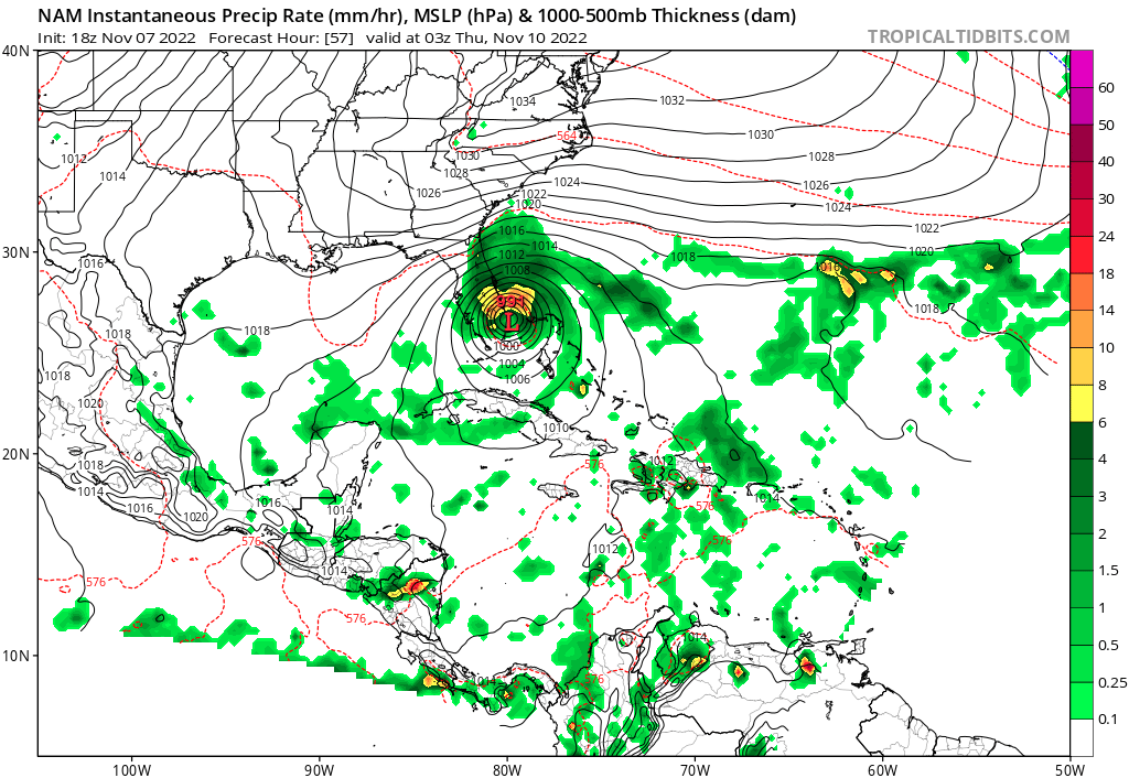
12Z Euro, unlike 6Z and 0Z, doesn't get to the GOM. So, the track is a bit NE of the prior two runs.
Edit: Correction: I was looking at 24 hour maps. The closer intervals show it barely in the NE GOM but it is a bit NE of the prior runs.
Edit: Correction: I was looking at 24 hour maps. The closer intervals show it barely in the NE GOM but it is a bit NE of the prior runs.
Last edited by LarryWx on Mon Nov 07, 2022 1:25 pm, edited 2 times in total.
1 likes
Personal Forecast Disclaimer:
The posts in this forum are NOT official forecasts and should not be used as such. They are just the opinion of the poster and may or may not be backed by sound meteorological data. They are NOT endorsed by any professional institution or storm2k.org. For official information, please refer to the NHC and NWS products.
The posts in this forum are NOT official forecasts and should not be used as such. They are just the opinion of the poster and may or may not be backed by sound meteorological data. They are NOT endorsed by any professional institution or storm2k.org. For official information, please refer to the NHC and NWS products.
-
AutoPenalti
- Category 5
- Posts: 4091
- Age: 29
- Joined: Mon Aug 17, 2015 4:16 pm
- Location: Ft. Lauderdale, Florida
Re: ATL: NICOLE - Models
SFLcane wrote:LarryWx wrote:12Z Euro 72 is 40 miles north of Lake Okeechobee vs west of the Lake on the 6Z at 78
lol 40 miles 20 miles this is not going to matter windfield will be huge.
It does the further south this goes.
2 likes
The posts in this forum are NOT official forecasts and should not be used as such. They are just the opinion of the poster and may or may not be backed by sound meteorological data. They are NOT endorsed by any professional institution or STORM2K. For official information, please refer to products from the NHC and NWS.
Model Runs Cheat Sheet:
GFS (5:30 AM/PM, 11:30 AM/PM)
HWRF, GFDL, UKMET, NAVGEM (6:30-8:00 AM/PM, 12:30-2:00 AM/PM)
ECMWF (1:45 AM/PM)
TCVN is a weighted averaged

-
Stormlover1970
- Tropical Low

- Posts: 32
- Age: 56
- Joined: Sun May 22, 2022 9:26 am
- Location: New Port Richey, Florida
Re: ATL: NICOLE - Models
nature coast pascoBobHarlem wrote:12z Euro only briefly goes into the Gulf around Cedar Key
https://i.imgur.com/7GgwW5Y.png
2 likes

Re: ATL: NICOLE - Models
Stormlover1970 wrote:nature coast pascoBobHarlem wrote:12z Euro only briefly goes into the Gulf around Cedar Key
https://i.imgur.com/7GgwW5Y.png
Nature coast yes, but it is in Levy County not Pasco. Pasco is south of my county in hernando and Levy is north of Citrus which is north of me.
1 likes
Robbielyn McCrary
I know just about enough to sound like I know what I'm talking about sometimes. But for your safety please follow the nhc for truly professional forecasting.
I know just about enough to sound like I know what I'm talking about sometimes. But for your safety please follow the nhc for truly professional forecasting.
-
Stormlover1970
- Tropical Low
- Posts: 32
- Age: 56
- Joined: Sun May 22, 2022 9:26 am
- Location: New Port Richey, Florida
Re: ATL: NICOLE - Models
I meant it passes over pascorobbielyn wrote:Stormlover1970 wrote:nature coast pascoBobHarlem wrote:12z Euro only briefly goes into the Gulf around Cedar Key
https://i.imgur.com/7GgwW5Y.png
Nature coast yes, but it is in Levy County not Pasco. Pasco is south of my county in hernando and Levy is north of Citrus I which is north of me.
0 likes
-
tolakram
- Admin

- Posts: 20186
- Age: 62
- Joined: Sun Aug 27, 2006 8:23 pm
- Location: Florence, KY (name is Mark)
Re: ATL: NICOLE - Models
Euro trend

0 likes
M a r k
- - - - -
Join us in chat: Storm2K Chatroom Invite. Android and IOS apps also available.
The posts in this forum are NOT official forecasts and should not be used as such. Posts are NOT endorsed by any professional institution or STORM2K.org. For official information and forecasts, please refer to NHC and NWS products.

Who is online
Users browsing this forum: No registered users and 8 guests