ATL: FIONA - Post-Tropical - Discussion

Moderator: S2k Moderators

Message
Author
User avatar
Iceresistance
Category 5
Category 5
Posts: 9288
Age: 21
Joined: Sat Oct 10, 2020 9:45 am
Location: Tecumseh, OK/Norman, OK

Re: ATL: SEVEN - Tropical Depression - Discussion

#181 Postby Iceresistance » Wed Sep 14, 2022 5:02 pm

Hammy wrote:
skyline385 wrote:

Just saying there have been plenty of cases recently of systems entering the Herbert box and missing Florida.


Sent from my iPhone using Tapatalk


To my knowledge the boxes are more for risk assessment, as storms that pass outside of them are less likely to hit Florida


I've always thought that the Herbert Boxes are there to highlight a higher-than-normal risk of a Florida Landfall if a storm crosses it.
1 likes   
Bill 2015 & Beta 2020

Winter 2020-2021 :cold:

All observations are in Tecumseh, OK unless otherwise noted.

Winter posts are focused mainly for Oklahoma & Texas.

Take any of my forecasts with a grain of salt, refer to the NWS, SPC, and NHC for official information

Never say Never with weather! Because ANYTHING is possible!

User avatar
msbee
S2K Supporter
S2K Supporter
Posts: 3027
Joined: Wed Jun 11, 2003 10:11 am
Location: St. Maarten

Re: ATL: SEVEN - Tropical Depression - Discussion

#182 Postby msbee » Wed Sep 14, 2022 5:05 pm

aspen wrote:The 5pm track has shifted a little north and is showing a poleward turn at 4-5 days, like what most of the models are showing now. This could get uncomfortably close to the CONUS after passing over the Lesser Antilles, PR, and Hispaniola.

coming my way, I guess
0 likes   
Too many hurricanes to remember

User avatar
skyline385
Category 5
Category 5
Posts: 2728
Age: 35
Joined: Wed Aug 26, 2020 11:15 pm
Location: Houston TX

Re: ATL: SEVEN - Tropical Depression - Discussion

#183 Postby skyline385 » Wed Sep 14, 2022 5:06 pm

Hammy wrote:
skyline385 wrote:

Just saying there have been plenty of cases recently of systems entering the Herbert box and missing Florida.


Sent from my iPhone using Tapatalk


To my knowledge the boxes are more for risk assessment, as storms that pass outside of them are less likely to hit Florida

Yea that’s what i think of them too


Sent from my iPhone using Tapatalk
0 likes   

User avatar
Spacecoast
Category 2
Category 2
Posts: 758
Joined: Thu Aug 31, 2017 2:03 pm

Re: ATL: SEVEN - Tropical Depression - Discussion

#184 Postby Spacecoast » Wed Sep 14, 2022 5:13 pm

skyline385 wrote:
Hammy wrote:
skyline385 wrote:Just saying there have been plenty of cases recently of systems entering the Herbert box and missing Florida.

To my knowledge the boxes are more for risk assessment, as storms that pass outside of them are less likely to hit Florida

Yea that’s what i think of them too

More applicable to stronger systems than TS's. but when a hurricane passes or develops in the Hebert Box #1 (since 1950)...

1. N Carolina has as much of a chance to get hit as Florida.
2. 20.58% go out to sea without hitting land.
3. Only 8.82% make it into the Gulf of Mexico when they pass through the box as a hurricane.
4. Puerto Rico will get hit 20.58% of the time (the highest outside of N Antilles).
7 likes   

al78
Professional-Met
Professional-Met
Posts: 332
Joined: Thu Nov 01, 2018 12:20 pm

Re: ATL: SEVEN - Tropical Depression - Discussion

#185 Postby al78 » Wed Sep 14, 2022 5:36 pm


Interesting, I thought it might have been the 1900 hurricane which motivated building the sea wall.

It does make me wonder when people have looked at trends in insured loss from hurricanes, whether as well as taking population, wealth and inflation into account, whether they have also taken mitigation, improved construction and building codes over the decades into account as well which I expect will act to reduce any trend in losses, like the other factors act to inflate the trend.
0 likes   

User avatar
Hypercane_Kyle
Category 5
Category 5
Posts: 3352
Joined: Sat Mar 07, 2015 7:58 pm
Location: Cape Canaveral, FL

Re: ATL: SEVEN - Tropical Depression - Discussion

#186 Postby Hypercane_Kyle » Wed Sep 14, 2022 5:38 pm

I'd keep a close eye on this one. Watch to see if the LLC manages to sneak south of Hispaniola.
0 likes   
My posts are my own personal opinion, defer to the National Hurricane Center (NHC) and other NOAA products for decision making during hurricane season.

User avatar
aspen
Category 5
Category 5
Posts: 8818
Joined: Sat Oct 12, 2019 7:10 pm
Location: Connecticut, USA

Re: ATL: SEVEN - Tropical Depression - Discussion

#187 Postby aspen » Wed Sep 14, 2022 5:59 pm

Hypercane_Kyle wrote:I'd keep a close eye on this one. Watch to see if the LLC manages to sneak south of Hispaniola.

Pretty much everywhere is on the table right now. If it pulls a Grace and relocates south of Hispaniola, this could be a threat to Cuba, Jamaica, the Yucatan, Mexico, or possibly the US Gulf coast. However, if it pulls an Isaias and relocates to the north, then it’ll probably go into the Bahamas, then from there it could threaten the US east coast, Atlantic Canada, or Bermuda. Both possible scenarios/tracks send this over regions of 29-30+ C SSTs for a span of at least a few days, which isn’t ideal for a system so close to land, even in a year like this.
5 likes   
Irene '11 Sandy '12 Hermine '16 5/15/2018 Derecho Fay '20 Isaias '20 Elsa '21 Henri '21 Ida '21

I am only a meteorology enthusiast who knows a decent amount about tropical cyclones. Look to the professional mets, the NHC, or your local weather office for the best information.

jlauderdal
S2K Supporter
S2K Supporter
Posts: 7182
Joined: Wed May 19, 2004 5:46 am
Location: NE Fort Lauderdale
Contact:

Re: RE: Re: ATL: SEVEN - Tropical Depression - Discussion

#188 Postby jlauderdal » Wed Sep 14, 2022 6:01 pm

msbee wrote:
aspen wrote:The 5pm track has shifted a little north and is showing a poleward turn at 4-5 days, like what most of the models are showing now. This could get uncomfortably close to the CONUS after passing over the Lesser Antilles, PR, and Hispaniola.

coming my way, I guess
Nothing you cant handle, no worries
1 likes   

User avatar
MGC
S2K Supporter
S2K Supporter
Posts: 5899
Joined: Sun Mar 23, 2003 9:05 pm
Location: Pass Christian MS, or what is left.

Re: ATL: SEVEN - Tropical Depression - Discussion

#189 Postby MGC » Wed Sep 14, 2022 6:03 pm

Yes, going to be a close call for the islands. Lets hope the dry air and shear hold TD7 in check. Nice blowup of convection this afternoon. Good chance for upgrade later this evening......MGC
3 likes   

User avatar
wxman57
Moderator-Pro Met
Moderator-Pro Met
Posts: 22978
Age: 67
Joined: Sat Jun 21, 2003 8:06 pm
Location: Houston, TX (southwest)

Re: ATL: SEVEN - Tropical Depression - Discussion

#190 Postby wxman57 » Wed Sep 14, 2022 6:19 pm

Iceresistance wrote:I've always thought that the HeRbert Boxes are there to highlight a higher-than-normal risk of a Florida Landfall if a storm crosses it.


First of all it's the HEBERT (French name) box, not the Herbert (British name) box. Paul Hebert was a Cajun from south Louisiana. Cajun Heberts don't like it when people don't bother to read or spell their names incorrectly. I met Paul at a hurricane conference years ago. We sat next to each other. Second, it is not a predictor of whether a storm will strike Florida. It only identifies that most storms which end up striking Florida passed through that box. Storms that pass outside that box are generally not a Florida threat. In that way, it is a predictor. As for this storm, there is nothing indicating any threat to Florida or the East U.S. Coast. Trend is recurve farther east. I'm still uncertain that this system qualifies as a depression. The circulation is so weak and removed from the convection.
11 likes   

User avatar
Iceresistance
Category 5
Category 5
Posts: 9288
Age: 21
Joined: Sat Oct 10, 2020 9:45 am
Location: Tecumseh, OK/Norman, OK

Re: ATL: SEVEN - Tropical Depression - Discussion

#191 Postby Iceresistance » Wed Sep 14, 2022 7:06 pm

ADT says that this is close to being Fiona

UW - CIMSS
ADVANCED DVORAK TECHNIQUE
ADT-Version 9.0
Tropical Cyclone Intensity Algorithm

----- Current Analysis -----
Date : 14 SEP 2022 Time : 233020 UTC
Lat : 16:50:54 N Lon : 50:56:48 W


CI# /Pressure/ Vmax
2.4 / 1007mb / 34kts


Final T# Adj T# Raw T#
2.3 2.0 2.0

Center Temp : -16.7C Cloud Region Temp : -43.5C

Scene Type : CURVED BAND with 0.33 ARC in LT GRAY
Maximum CURVED BAND with 0.48 ARC in LT GRAY
at Lat: 15:50:24 N Lon: 50:56:23 W
4 likes   
Bill 2015 & Beta 2020

Winter 2020-2021 :cold:

All observations are in Tecumseh, OK unless otherwise noted.

Winter posts are focused mainly for Oklahoma & Texas.

Take any of my forecasts with a grain of salt, refer to the NWS, SPC, and NHC for official information

Never say Never with weather! Because ANYTHING is possible!

tolakram
Admin
Admin
Posts: 20009
Age: 62
Joined: Sun Aug 27, 2006 8:23 pm
Location: Florence, KY (name is Mark)

Re: ATL: SEVEN - Tropical Depression - Discussion

#192 Postby tolakram » Wed Sep 14, 2022 7:13 pm

1 likes   
M a r k
- - - - -
Join us in chat: Storm2K Chatroom Invite. Android and IOS apps also available.

The posts in this forum are NOT official forecasts and should not be used as such. Posts are NOT endorsed by any professional institution or STORM2K.org. For official information and forecasts, please refer to NHC and NWS products.

tolakram
Admin
Admin
Posts: 20009
Age: 62
Joined: Sun Aug 27, 2006 8:23 pm
Location: Florence, KY (name is Mark)

Re: ATL: SEVEN - Tropical Depression - Discussion

#193 Postby tolakram » Wed Sep 14, 2022 7:17 pm

1 likes   
M a r k
- - - - -
Join us in chat: Storm2K Chatroom Invite. Android and IOS apps also available.

The posts in this forum are NOT official forecasts and should not be used as such. Posts are NOT endorsed by any professional institution or STORM2K.org. For official information and forecasts, please refer to NHC and NWS products.

Sciencerocks
Category 5
Category 5
Posts: 9155
Age: 39
Joined: Thu Jul 06, 2017 1:51 am

Re: ATL: SEVEN - Tropical Depression - Discussion

#194 Postby Sciencerocks » Wed Sep 14, 2022 7:31 pm

Image
0 likes   

User avatar
cycloneye
Admin
Admin
Posts: 145295
Age: 68
Joined: Thu Oct 10, 2002 10:54 am
Location: San Juan, Puerto Rico

Re: ATL: SEVEN - Tropical Depression - Discussion

#195 Postby cycloneye » Wed Sep 14, 2022 7:41 pm

AL, 07, 2022091500, , BEST, 0, 169N, 514W, 30, 1008, TD


https://ftp.nhc.noaa.gov/atcf/btk/bal072022.dat
0 likes   
Visit the Caribbean-Central America Weather Thread where you can find at first post web cams,radars
and observations from Caribbean basin members Click Here

User avatar
msbee
S2K Supporter
S2K Supporter
Posts: 3027
Joined: Wed Jun 11, 2003 10:11 am
Location: St. Maarten

Re: RE: Re: ATL: SEVEN - Tropical Depression - Discussion

#196 Postby msbee » Wed Sep 14, 2022 7:42 pm

jlauderdal wrote:
msbee wrote:
aspen wrote:The 5pm track has shifted a little north and is showing a poleward turn at 4-5 days, like what most of the models are showing now. This could get uncomfortably close to the CONUS after passing over the Lesser Antilles, PR, and Hispaniola.

coming my way, I guess
Nothing you cant handle, no worries

I agree. After Irma we can handle anything.
3 likes   
Too many hurricanes to remember

User avatar
Blown Away
S2K Supporter
S2K Supporter
Posts: 10145
Joined: Wed May 26, 2004 6:17 am

Re: ATL: SEVEN - Tropical Depression - Discussion

#197 Postby Blown Away » Wed Sep 14, 2022 7:43 pm

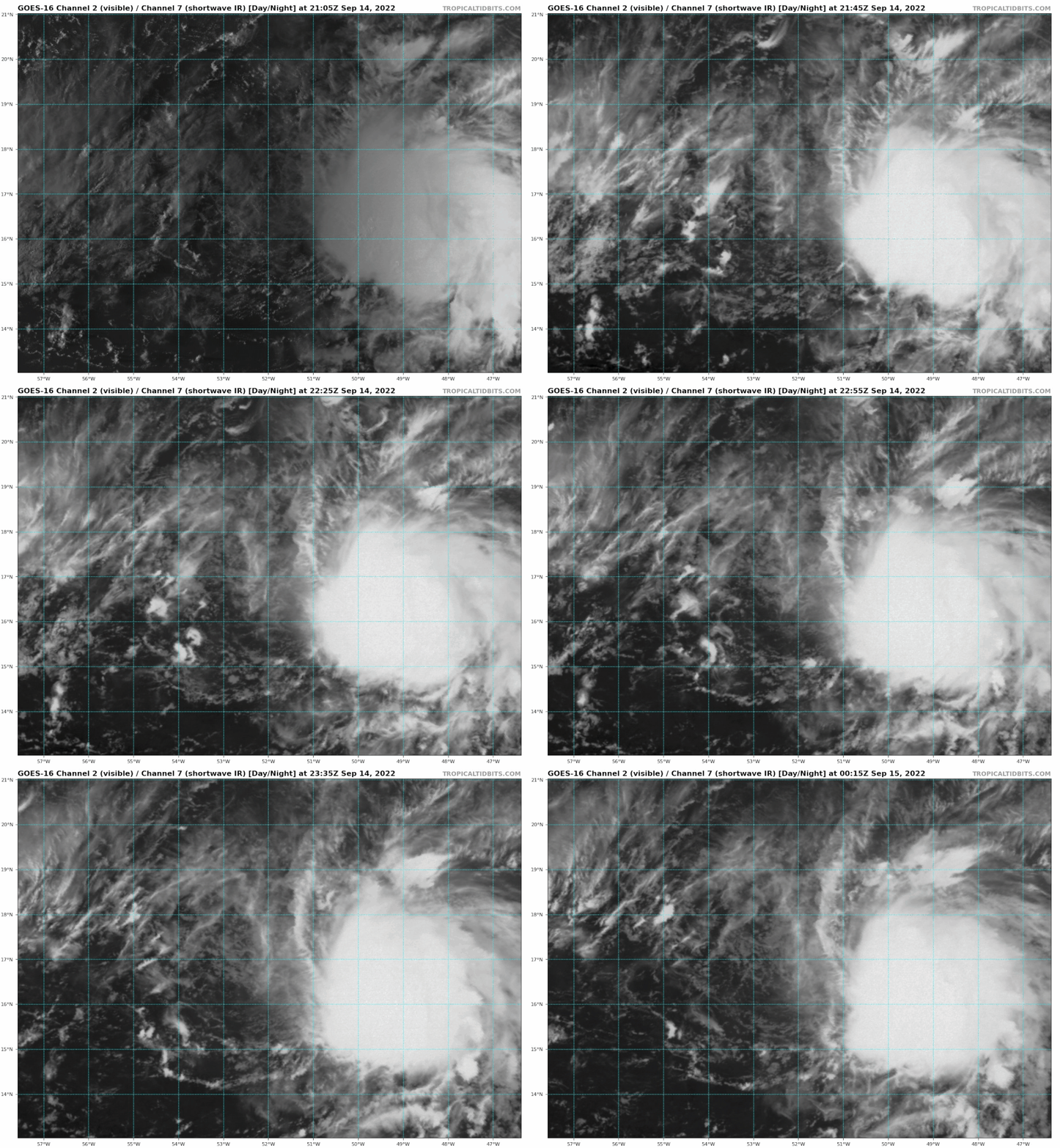
Image

Latest position is @16.9N/51.4W, appears TD7’s LLC is racing W exposed and convection is stuck… Shear must be picking up…
0 likes   
Hurricane Eye Experience: David 79, Irene 99, Frances 04, Jeanne 04, Wilma 05... EYE COMING MY WAY IN 2024…
Hurricane Brush Experience: Andrew 92, Erin 95, Floyd 99, Matthew 16, Irma 17, Ian 22, Nicole 22…

User avatar
InfernoFlameCat
Category 5
Category 5
Posts: 2102
Age: 22
Joined: Mon Dec 14, 2020 10:52 am
Location: Buford, GA

Re: ATL: SEVEN - Tropical Depression - Discussion

#198 Postby InfernoFlameCat » Wed Sep 14, 2022 7:44 pm

Blown Away wrote:[url]https://i.postimg.cc/dQ2nH8HL/goes16-vis-swir-07-L-202209142105.gif [/url]

Latest position is @16.9N/51.4W, appears TD7’s LLC is racing W exposed and convection is stuck… Shear must be picking up…

reminds me of earl. I hate shear sometimes
3 likes   
I am by no means a professional. DO NOT look at my forecasts for official information or make decisions based on what I post.

Goal: to become a registered expert over tropical and subtropical cyclones.

User avatar
ScottNAtlanta
Category 5
Category 5
Posts: 2367
Joined: Sat May 25, 2013 3:11 pm
Location: Atlanta, GA

Re: ATL: SEVEN - Tropical Depression - Discussion

#199 Postby ScottNAtlanta » Wed Sep 14, 2022 8:05 pm

It is definitely hitting a wall, but systems like this...if they are able to wait out the shear will usually be formidable at some point.
0 likes   
The posts in this forum are NOT official forecast and should not be used as such. They are just the opinion of the poster and may or may not be backed by sound meteorological data. They are NOT endorsed by any professional institution or storm2k.org. For official information, please refer to the NHC and NWS products.

User avatar
cycloneye
Admin
Admin
Posts: 145295
Age: 68
Joined: Thu Oct 10, 2002 10:54 am
Location: San Juan, Puerto Rico

Re: ATL: SEVEN - Tropical Depression - Discussion

#200 Postby cycloneye » Wed Sep 14, 2022 8:11 pm

TXNT23 KNES 150006
TCSNTL

A. 07L (NONAME)

B. 14/2330Z

C. 16.8N

D. 50.5W

E. THREE/GOES-E

F. T1.5/1.5

G. IR/EIR/SWIR/SSMIS

H. REMARKS...CONVECTION WRAPS .3 ON LOG10 SPIRAL YIELDING A DT OF
1.5. MET AND PT AGREE. THE FT IS BASED ON THE DT.

I. ADDL POSITIONS

14/2002Z 16.9N 50.5W SSMIS


...KIBLER
0 likes   
Visit the Caribbean-Central America Weather Thread where you can find at first post web cams,radars
and observations from Caribbean basin members Click Here


Return to “2022”

Who is online

Users browsing this forum: No registered users and 4 guests