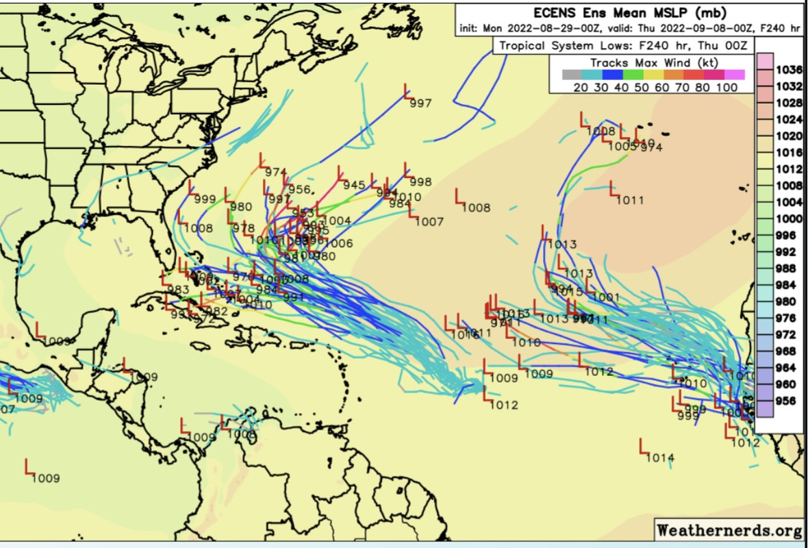
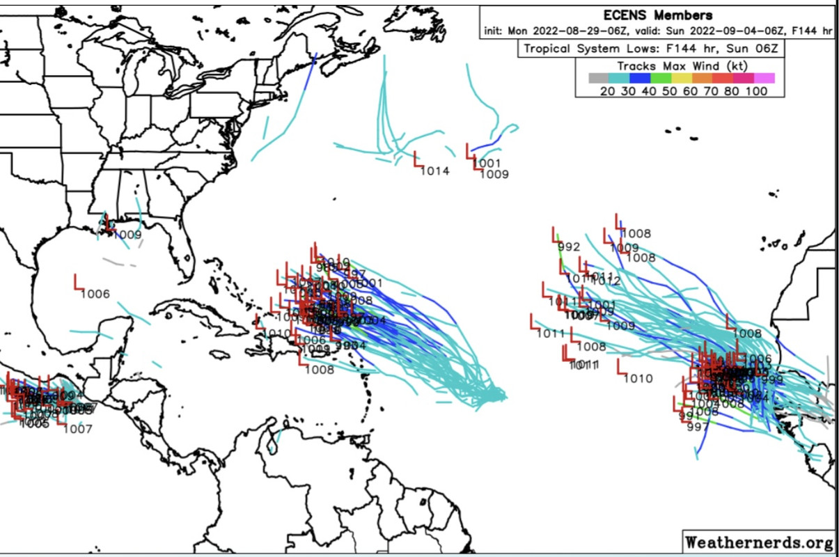
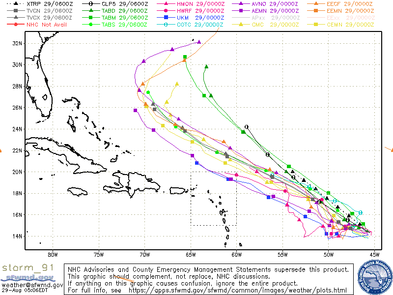
ATL: EARL - Models

Moderator: S2k Moderators

Message
Author
User avatar
SFLcane
S2K Supporter
S2K Supporter
Posts: 10163
Age: 47
Joined: Sat Jun 05, 2010 1:44 pm
Location: Lake Worth Florida

Re: ATL: INVEST 91L - Models

#181 Postby SFLcane » Mon Aug 29, 2022 4:40 am

cycloneye wrote:
SFLcane wrote:Likely won’t bother anyone but fish.

https://i.postimg.cc/HxJTmcpB/5-AECEC15-EE1-B-4-EDC-AD66-ACBEF1767347.gif


There is an island in the middle of the Atlantic named Bermuda.


Lol almost forgot Yea Bermuda. Hopefully not much of a concern for them.
1 likes   

MHC Tracking
Tropical Storm
Tropical Storm
Posts: 195
Joined: Mon Mar 15, 2021 10:05 am

Re: ATL: INVEST 91L - Models

#182 Postby MHC Tracking » Mon Aug 29, 2022 4:59 am

Looks like 06z GFS completely junks the Gulf modelcane. We can now take the model output for 91L more seriously.
0 likes   

User avatar
aspen
Category 5
Category 5
Posts: 8818
Joined: Sat Oct 12, 2019 7:10 pm
Location: Connecticut, USA

Re: ATL: INVEST 91L - Models

#183 Postby aspen » Mon Aug 29, 2022 6:32 am

Impressive. Every single global model develops 91L and makes it a hurricane, and they all have pretty much the same close call OTS track. Even the CMC agrees with the rest, and it’s been the most conservative model all year.
3 likes   
Irene '11 Sandy '12 Hermine '16 5/15/2018 Derecho Fay '20 Isaias '20 Elsa '21 Henri '21 Ida '21

I am only a meteorology enthusiast who knows a decent amount about tropical cyclones. Look to the professional mets, the NHC, or your local weather office for the best information.

User avatar
Category5Kaiju
Category 5
Category 5
Posts: 4095
Joined: Thu Dec 24, 2020 12:45 pm
Location: Seattle

Re: ATL: INVEST 91L - Models

#184 Postby Category5Kaiju » Mon Aug 29, 2022 6:36 am

Wait so the ridging that was predicted merely days ago is no longer the case? I’m just curious as to what models are seeing that make them want to think that this thing’s gonna make a sharp recurve right off the Bahamas coast
0 likes   
Unless explicitly stated, all info in my posts is based on my own opinions and observations. Tropical storms and hurricanes can be extremely dangerous. Do not think you can beat Mother Nature. Refer to an accredited weather research agency or meteorologist if you need to make serious decisions regarding an approaching storm.

User avatar
pgoss11
Category 2
Category 2
Posts: 702
Joined: Tue Sep 02, 2003 3:55 pm

Re: ATL: INVEST 91L - Models

#185 Postby pgoss11 » Mon Aug 29, 2022 6:45 am

I have to think that until we have an actual storm these runs will vary. This future storm is over a week out from affecting the CONUS, if it does, and we know how fickle model runs can be this far out.
2 likes   

AutoPenalti
Category 5
Category 5
Posts: 4030
Age: 29
Joined: Mon Aug 17, 2015 4:16 pm
Location: Ft. Lauderdale, Florida

Re: ATL: INVEST 91L - Models

#186 Postby AutoPenalti » Mon Aug 29, 2022 7:14 am

I thought models already pointed to a CoC?
0 likes   
The posts in this forum are NOT official forecasts and should not be used as such. They are just the opinion of the poster and may or may not be backed by sound meteorological data. They are NOT endorsed by any professional institution or STORM2K. For official information, please refer to products from the NHC and NWS.


Model Runs Cheat Sheet:
GFS (5:30 AM/PM, 11:30 AM/PM)
HWRF, GFDL, UKMET, NAVGEM (6:30-8:00 AM/PM, 12:30-2:00 AM/PM)
ECMWF (1:45 AM/PM)

TCVN
is a weighted averaged

Nederlander
S2K Supporter
S2K Supporter
Posts: 1250
Joined: Sat Jul 19, 2008 4:28 pm
Location: Conroe, TX

Re: ATL: INVEST 91L - Models

#187 Postby Nederlander » Mon Aug 29, 2022 7:30 am

Category5Kaiju wrote:Wait so the ridging that was predicted merely days ago is no longer the case? I’m just curious as to what models are seeing that make them want to think that this thing’s gonna make a sharp recurve right off the Bahamas coast

Trough expected to open the escape hatch.
1 likes   

User avatar
toad strangler
S2K Supporter
S2K Supporter
Posts: 4543
Joined: Sun Jul 28, 2013 3:09 pm
Location: Earth
Contact:

Re: ATL: INVEST 91L - Models

#188 Postby toad strangler » Mon Aug 29, 2022 7:58 am

Category5Kaiju wrote:Wait so the ridging that was predicted merely days ago is no longer the case? I’m just curious as to what models are seeing that make them want to think that this thing’s gonna make a sharp recurve right off the Bahamas coast


500mb can't be trusted outside of 24 - 48 hours
2 likes   

tomatkins
Tropical Storm
Tropical Storm
Posts: 222
Joined: Wed Sep 05, 2018 2:11 pm

Re: ATL: INVEST 91L - Models

#189 Postby tomatkins » Mon Aug 29, 2022 8:07 am

Nederlander wrote:
Category5Kaiju wrote:Wait so the ridging that was predicted merely days ago is no longer the case? I’m just curious as to what models are seeing that make them want to think that this thing’s gonna make a sharp recurve right off the Bahamas coast

Trough expected to open the escape hatch.

Any time you see a stall this early on, assume its gonna be a recurve (or less likely, a long tracker - anything but a stall). To get a stall requires a fine balance of forces that is almost impossible to predict this far out.
1 likes   

User avatar
skyline385
Category 5
Category 5
Posts: 2728
Age: 35
Joined: Wed Aug 26, 2020 11:15 pm
Location: Houston TX

Re: ATL: INVEST 91L - Models

#190 Postby skyline385 » Mon Aug 29, 2022 8:10 am

0 likes   

User avatar
Blown Away
S2K Supporter
S2K Supporter
Posts: 10145
Joined: Wed May 26, 2004 6:17 am

Re: ATL: INVEST 91L - Models

#191 Postby Blown Away » Mon Aug 29, 2022 8:36 am

Image
00z ECENS

Image
06z ECENS
0 likes   
Hurricane Eye Experience: David 79, Irene 99, Frances 04, Jeanne 04, Wilma 05... EYE COMING MY WAY IN 2024…
Hurricane Brush Experience: Andrew 92, Erin 95, Floyd 99, Matthew 16, Irma 17, Ian 22, Nicole 22…

User avatar
pgoss11
Category 2
Category 2
Posts: 702
Joined: Tue Sep 02, 2003 3:55 pm

Re: ATL: INVEST 91L - Models

#192 Postby pgoss11 » Mon Aug 29, 2022 8:43 am

0 likes   

AutoPenalti
Category 5
Category 5
Posts: 4030
Age: 29
Joined: Mon Aug 17, 2015 4:16 pm
Location: Ft. Lauderdale, Florida

Re: ATL: INVEST 91L - Models

#193 Postby AutoPenalti » Mon Aug 29, 2022 8:54 am


Spread is wider in the medium range.
Image
2 likes   
The posts in this forum are NOT official forecasts and should not be used as such. They are just the opinion of the poster and may or may not be backed by sound meteorological data. They are NOT endorsed by any professional institution or STORM2K. For official information, please refer to products from the NHC and NWS.


Model Runs Cheat Sheet:
GFS (5:30 AM/PM, 11:30 AM/PM)
HWRF, GFDL, UKMET, NAVGEM (6:30-8:00 AM/PM, 12:30-2:00 AM/PM)
ECMWF (1:45 AM/PM)

TCVN
is a weighted averaged

sma10
Category 5
Category 5
Posts: 1710
Joined: Tue Aug 02, 2005 1:13 pm

Re: ATL: INVEST 91L - Models

#194 Postby sma10 » Mon Aug 29, 2022 9:38 am

toad strangler wrote:
Category5Kaiju wrote:Wait so the ridging that was predicted merely days ago is no longer the case? I’m just curious as to what models are seeing that make them want to think that this thing’s gonna make a sharp recurve right off the Bahamas coast


500mb can't be trusted outside of 24 - 48 hours


Even if being charitable and saying 4-5 days out could potentially give a trusted signal .. you certainly cannot trust 7-10 days. And this is true even in a relatively benign pattern.

The SW Atlantic setup next week looks highly complex. Add to the mix a very tricky genesis, plus unknown system strength, we're still almost in dartboard territory here
1 likes   

LarryWx
S2K Supporter
S2K Supporter
Posts: 6304
Joined: Sun Sep 07, 2003 2:04 pm
Location: GA

Re: ATL: INVEST 91L - Models

#195 Postby LarryWx » Mon Aug 29, 2022 9:55 am

0Z EPS still strongly favors missing FL to the east. But there remain about 10% of members that head toward Cuba and then turn north into FL meaning don't rest easy just yet. Furthermore, the 6Z EPS at its 144 cutoff does have a bigger spread with more members in the southern envelope of possibilities vs the 0Z EPS meaning most likely a somewhat higher than 10% danger to FL.
2 likes   
Personal Forecast Disclaimer:
The posts in this forum are NOT official forecasts and should not be used as such. They are just the opinion of the poster and may or may not be backed by sound meteorological data. They are NOT endorsed by any professional institution or storm2k.org. For official information, please refer to the NHC and NWS products.

User avatar
Spacecoast
Category 2
Category 2
Posts: 758
Joined: Thu Aug 31, 2017 2:03 pm

Re: ATL: INVEST 91L - Models

#196 Postby Spacecoast » Mon Aug 29, 2022 10:18 am

Really liking Tomer's site for graphics / info...
Image
Image
Image
Image
3 likes   

User avatar
skyline385
Category 5
Category 5
Posts: 2728
Age: 35
Joined: Wed Aug 26, 2020 11:15 pm
Location: Houston TX

Re: ATL: INVEST 91L - Models

#197 Postby skyline385 » Mon Aug 29, 2022 10:45 am

Spacecoast wrote:Really liking Tomer's site for graphics / info...
Image
Image
Image
Image

Are you using tropycal to generate these or does he have them on his site to use?


Sent from my iPhone using Tapatalk
0 likes   

User avatar
Blown Away
S2K Supporter
S2K Supporter
Posts: 10145
Joined: Wed May 26, 2004 6:17 am

Re: ATL: INVEST 91L - Models

#198 Postby Blown Away » Mon Aug 29, 2022 10:48 am

I’m struggling w/ that very sharp recurve in Aug/Sept at only @30N. I think models may be moving 91L to fast and to quick to go NW. I’m not saying it will impact Bahamas or CONUS. I just think there will be a W trend mostly due to a slower system in the models. JMHO.
1 likes   
Hurricane Eye Experience: David 79, Irene 99, Frances 04, Jeanne 04, Wilma 05... EYE COMING MY WAY IN 2024…
Hurricane Brush Experience: Andrew 92, Erin 95, Floyd 99, Matthew 16, Irma 17, Ian 22, Nicole 22…

User avatar
Spacecoast
Category 2
Category 2
Posts: 758
Joined: Thu Aug 31, 2017 2:03 pm

Re: ATL: INVEST 91L - Models

#199 Postby Spacecoast » Mon Aug 29, 2022 10:49 am

skyline385 wrote:
Spacecoast wrote:Really liking Tomer's site for graphics / info...

Are you using tropycal to generate these or does he have them on his site to use?


Sent from my iPhone using Tapatalk

He has them on his site:
http://arctic.som.ou.edu/tburg/products/
Here's another 91L graphic...
Image
0 likes   

User avatar
aspen
Category 5
Category 5
Posts: 8818
Joined: Sat Oct 12, 2019 7:10 pm
Location: Connecticut, USA

Re: ATL: INVEST 91L - Models

#200 Postby aspen » Mon Aug 29, 2022 10:53 am

ICON finishes off at 948mb — very strong for this model — and still hasn’t started recurving. So far it still has the most SW track out of the global models.
0 likes   
Irene '11 Sandy '12 Hermine '16 5/15/2018 Derecho Fay '20 Isaias '20 Elsa '21 Henri '21 Ida '21

I am only a meteorology enthusiast who knows a decent amount about tropical cyclones. Look to the professional mets, the NHC, or your local weather office for the best information.


Return to “2022”

Who is online

Users browsing this forum: No registered users and 4 guests