ATL: FIONA - Models

Moderator: S2k Moderators

Message
Author
caneman
Category 5
Category 5
Posts: 1447
Joined: Fri Sep 05, 2014 5:44 am
Location: Clearwater Beach, Fl

Re: ATL: SEVEN - Models

#141 Postby caneman » Wed Sep 14, 2022 6:00 pm

gatorcane wrote:The GFS shows a clear weakness over Florida and the SW Atlantic with the Bermuda High shunted east. So the storms turns north over the Eastern Bahamas. The forecast is similar to the Euro.


The only thing clear is that is a long way off and error margins are huge at that range
3 likes   

User avatar
Jr0d
S2K Supporter
S2K Supporter
Posts: 1409
Joined: Tue Aug 27, 2019 10:52 am
Location: Cayo Hueso

Re: ATL: SEVEN - Models

#142 Postby Jr0d » Wed Sep 14, 2022 6:17 pm

caneman wrote:
gatorcane wrote:The GFS shows a clear weakness over Florida and the SW Atlantic with the Bermuda High shunted east. So the storms turns north over the Eastern Bahamas. The forecast is similar to the Euro.


The only thing clear is that is a long way off and error margins are huge at that range


The overall pattern this year is OTS, Even without modem support it would be the safe guess. We will see though.

Definitely a possible mid to NE threat down the road...in my amateur opinion. Florida is not 100% safe but highly unlikely again just my opinion
3 likes   

caneman
Category 5
Category 5
Posts: 1447
Joined: Fri Sep 05, 2014 5:44 am
Location: Clearwater Beach, Fl

Re: ATL: SEVEN - Models

#143 Postby caneman » Wed Sep 14, 2022 6:39 pm

Jr0d wrote:
caneman wrote:
gatorcane wrote:The GFS shows a clear weakness over Florida and the SW Atlantic with the Bermuda High shunted east. So the storms turns north over the Eastern Bahamas. The forecast is similar to the Euro.


The only thing clear is that is a long way off and error margins are huge at that range


The overall pattern this year is OTS, Even without modem support it would be the safe guess. We will see though.

Definitely a possible mid to NE threat down the road...in my amateur opinion. Florida is not 100% safe but highly unlikely again just my opinion


There are many years with the majority of storms going out to sea yet 1 or 2 sneak through
1 likes   

User avatar
SFLcane
S2K Supporter
S2K Supporter
Posts: 10163
Age: 47
Joined: Sat Jun 05, 2010 1:44 pm
Location: Lake Worth Florida

Re: ATL: SEVEN - Models

#144 Postby SFLcane » Wed Sep 14, 2022 8:00 pm

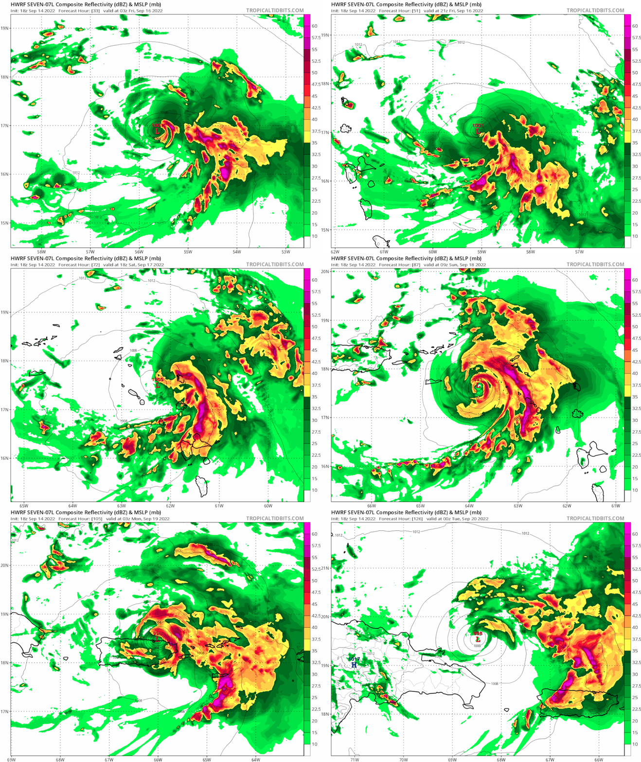
18z HWRF is west…

Image
1 likes   

BobHarlem
Category 5
Category 5
Posts: 2105
Joined: Thu Oct 20, 2005 6:11 pm

Re: ATL: SEVEN - Models

#145 Postby BobHarlem » Wed Sep 14, 2022 8:25 pm

0z Earlies. Notable TVCN shifted west, it was right of the official track at 18z, now it's left of it.
Image
Last edited by BobHarlem on Wed Sep 14, 2022 9:40 pm, edited 1 time in total.
3 likes   

tolakram
Admin
Admin
Posts: 20009
Age: 62
Joined: Sun Aug 27, 2006 8:23 pm
Location: Florence, KY (name is Mark)

Re: ATL: SEVEN - Models

#146 Postby tolakram » Wed Sep 14, 2022 8:33 pm

18Z Euro
Image
4 likes   
M a r k
- - - - -
Join us in chat: Storm2K Chatroom Invite. Android and IOS apps also available.

The posts in this forum are NOT official forecasts and should not be used as such. Posts are NOT endorsed by any professional institution or STORM2K.org. For official information and forecasts, please refer to NHC and NWS products.

User avatar
toad strangler
S2K Supporter
S2K Supporter
Posts: 4543
Joined: Sun Jul 28, 2013 3:09 pm
Location: Earth
Contact:

Re: ATL: SEVEN - Models

#147 Postby toad strangler » Wed Sep 14, 2022 8:37 pm

Jr0d wrote:
caneman wrote:
gatorcane wrote:The GFS shows a clear weakness over Florida and the SW Atlantic with the Bermuda High shunted east. So the storms turns north over the Eastern Bahamas. The forecast is similar to the Euro.


The only thing clear is that is a long way off and error margins are huge at that range


The overall pattern this year is OTS, Even without modem support it would be the safe guess. We will see though.

Definitely a possible mid to NE threat down the road...in my amateur opinion. Florida is not 100% safe but highly unlikely again just my opinion


The overall pattern almost every single year in recorded history with systems in this spot is OTS. It’s the Atlantic Basin super highway. That’s the safest call to make at this juncture.
Last edited by toad strangler on Wed Sep 14, 2022 8:38 pm, edited 1 time in total.
3 likes   

tolakram
Admin
Admin
Posts: 20009
Age: 62
Joined: Sun Aug 27, 2006 8:23 pm
Location: Florence, KY (name is Mark)

Re: ATL: SEVEN - Models

#148 Postby tolakram » Wed Sep 14, 2022 8:38 pm

HWRF, unrealistically aggressive based on expected conditions IMO.

Image
2 likes   
M a r k
- - - - -
Join us in chat: Storm2K Chatroom Invite. Android and IOS apps also available.

The posts in this forum are NOT official forecasts and should not be used as such. Posts are NOT endorsed by any professional institution or STORM2K.org. For official information and forecasts, please refer to NHC and NWS products.

caneman
Category 5
Category 5
Posts: 1447
Joined: Fri Sep 05, 2014 5:44 am
Location: Clearwater Beach, Fl

Re: ATL: SEVEN - Models

#149 Postby caneman » Wed Sep 14, 2022 8:58 pm

toad strangler wrote:
Jr0d wrote:
caneman wrote:
The only thing clear is that is a long way off and error margins are huge at that range


The overall pattern this year is OTS, Even without modem support it would be the safe guess. We will see though.

Definitely a possible mid to NE threat down the road...in my amateur opinion. Florida is not 100% safe but highly unlikely again just my opinion


The overall pattern almost every single year in recorded history with systems in this spot is OTS. It’s the Atlantic Basin super highway. That’s the safest call to make at this juncture.


There is no safe call to make right now. It's too far out and some models have shifted West. Some taking it just South of the islands. Some keep it weaker and further West. There is no super highway OTS from just below the islands. And each storm and set up and timing is completely unique. I don't care if 90% of storms go out to sea. You don't know which will be the 10%.
5 likes   

BobHarlem
Category 5
Category 5
Posts: 2105
Joined: Thu Oct 20, 2005 6:11 pm

Re: ATL: SEVEN - Models

#150 Postby BobHarlem » Wed Sep 14, 2022 9:00 pm

tolakram wrote:HWRF, unrealistically aggressive based on expected conditions IMO.

https://i.imgur.com/vGxSryO.gif


After the upgrade to Fiona, I wonder how far off this really will be. The fact that this system has been stronger than what much of the guidance has suggested is a bit concerning to me.
5 likes   

User avatar
SFLcane
S2K Supporter
S2K Supporter
Posts: 10163
Age: 47
Joined: Sat Jun 05, 2010 1:44 pm
Location: Lake Worth Florida

Re: ATL: SEVEN - Models

#151 Postby SFLcane » Wed Sep 14, 2022 9:36 pm

Indeed!

BobHarlem wrote:0z Earlies. Notablle TVCN shifted west, it was right of the official track at 18z, now it's left of it.
https://i.imgur.com/5Tf5XQu.png
0 likes   

floridasun
Tropical Storm
Tropical Storm
Posts: 200
Joined: Tue Sep 14, 2021 3:59 pm

Re: ATL: FIONA - Models

#152 Postby floridasun » Wed Sep 14, 2022 9:41 pm

i think all depend on weakness that may happen with high off coast line
0 likes   

BobHarlem
Category 5
Category 5
Posts: 2105
Joined: Thu Oct 20, 2005 6:11 pm

Re: ATL: FIONA - Models

#153 Postby BobHarlem » Wed Sep 14, 2022 10:43 pm

0z Icon stays south of Puerto Rico and cuts a hard right just as it gets near Hispaniola. It winds up east of the 12z position toward the end, generally heading near or west of Bermuda.
0 likes   

User avatar
SouthFLTropics
Category 5
Category 5
Posts: 4236
Age: 50
Joined: Thu Aug 14, 2003 8:04 am
Location: Port St. Lucie, Florida

Re: ATL: FIONA - Models

#154 Postby SouthFLTropics » Wed Sep 14, 2022 11:31 pm

CMC is all in on its west track… stays weak just long enough to miss the northeast connection and slips in under the ridge and is GOM bound. Either the CMC is a genius or it’s in crack. I’m guessing the latter.


Sent from my iPhone using Tapatalk
0 likes   
Fourth Generation Florida Native

Personal Storm History: David 79, Andrew 92, Erin 95, Floyd 99, Irene 99, Frances 04, Jeanne 04, Wilma 05, Matthew 16, Irma 17, Ian 22, Nicole 22, Milton 24

User avatar
ElectricStorm
Category 5
Category 5
Posts: 5044
Age: 24
Joined: Tue Aug 13, 2019 11:23 pm
Location: Skiatook, OK / Norman, OK

Re: ATL: FIONA - Models

#155 Postby ElectricStorm » Wed Sep 14, 2022 11:34 pm

0z GFS stronger with a potential hurricane threat for PR. Looks like its overall much further east than the 18z run which makes sense to me, stronger storms usually get north quicker.

Edit: Looks like it's turning back to the west as a major near Bermuda. Way far out though
0 likes   
B.S Meteorology, University of Oklahoma '25

Please refer to the NHC, NWS, or SPC for official information.

Keldeo1997
Category 2
Category 2
Posts: 637
Joined: Fri Oct 11, 2019 11:35 pm

Re: ATL: FIONA - Models

#156 Postby Keldeo1997 » Wed Sep 14, 2022 11:37 pm

Looks like its getting trapped. Watch out east coast.
0 likes   

User avatar
SouthFLTropics
Category 5
Category 5
Posts: 4236
Age: 50
Joined: Thu Aug 14, 2003 8:04 am
Location: Port St. Lucie, Florida

Re: ATL: FIONA - Models

#157 Postby SouthFLTropics » Wed Sep 14, 2022 11:44 pm

CMC has it in for NOLA… Katrina repeat if that happens.


Sent from my iPhone using Tapatalk
0 likes   
Fourth Generation Florida Native

Personal Storm History: David 79, Andrew 92, Erin 95, Floyd 99, Irene 99, Frances 04, Jeanne 04, Wilma 05, Matthew 16, Irma 17, Ian 22, Nicole 22, Milton 24

User avatar
SouthFLTropics
Category 5
Category 5
Posts: 4236
Age: 50
Joined: Thu Aug 14, 2003 8:04 am
Location: Port St. Lucie, Florida

Re: ATL: FIONA - Models

#158 Postby SouthFLTropics » Wed Sep 14, 2022 11:46 pm

Keldeo1997 wrote:Looks like its getting trapped. Watch out east coast.

Looks like a slowdown and possibly a loop but on the 500mb there is clearly an exit North. Should get scooped up and out.


Sent from my iPhone using Tapatalk
0 likes   
Fourth Generation Florida Native

Personal Storm History: David 79, Andrew 92, Erin 95, Floyd 99, Irene 99, Frances 04, Jeanne 04, Wilma 05, Matthew 16, Irma 17, Ian 22, Nicole 22, Milton 24

User avatar
blp
Category 5
Category 5
Posts: 2840
Age: 46
Joined: Thu Sep 09, 2004 7:51 pm
Location: Miami, FL
Contact:

Re: ATL: FIONA - Models

#159 Postby blp » Wed Sep 14, 2022 11:47 pm

GEFS is further west than the Ops run
0 likes   
The following post is NOT an official forecast and should not be used as such. It is just the opinion of the poster and may or may not be backed by sound meteorological data. It is NOT endorsed by any professional institution including storm2k.org For Official Information please refer to the NHC and NWS products.

User avatar
cheezyWXguy
Category 5
Category 5
Posts: 6108
Joined: Mon Feb 13, 2006 12:29 am
Location: Dallas, TX

Re: ATL: FIONA - Models

#160 Postby cheezyWXguy » Wed Sep 14, 2022 11:48 pm

SouthFLTropics wrote:CMC is all in on its west track… stays weak just long enough to miss the northeast connection and slips in under the ridge and is GOM bound. Either the CMC is a genius or it’s in crack. I’m guessing the latter.


Sent from my iPhone using Tapatalk

Actually seems like a pretty significant eastward shift to me, at least in the long range. Maybe it’s finally on its way to eventually converge with the other solutions
0 likes   


Return to “2022”

Who is online

Users browsing this forum: No registered users and 4 guests