https://twitter.com/AndyHazelton/status/1563990177470681090
Need to watch this. I can tell you a certain "D" storm that really benefited from Center relocations...
ATL: EARL - Post-Tropical - Discussion
Moderator: S2k Moderators
-
Keldeo1997
- Category 2

- Posts: 688
- Joined: Fri Oct 11, 2019 11:35 pm
Re: ATL: INVEST 91L - Discussion
0 likes

Re: ATL: INVEST 91L - Discussion
skyline385 wrote:Blown Away wrote:Nearly all the hurricanes that impact SFL from the E will have to come in S of 25N/70-75W to make it. Nearly all above those marks will miss, 12z ECMWF was N of those marks so recurve away from SFL likely.
Well 12Z ECMWF was actually very similar to the 1947 FLL cane which was the one exception to what you said above.
The 1947 Hurricane bombed in the same way current models are suggesting just before landfall in Ft Lauderdale and prompted Congress to pass legislation to improve the Levees in New Orleans.
3 likes
-
Blown Away

- S2K Supporter

- Posts: 10253
- Joined: Wed May 26, 2004 6:17 am
Re: ATL: INVEST 91L - Discussion
91L still chugging W.
3 likes
Hurricane Eye Experience: David 79, Irene 99, Frances 04, Jeanne 04, Wilma 05… Hurricane Brush Experience: Andrew 92, Erin 95, Floyd 99, Matthew 16, Irma 17, Ian 22, Nicole 22…
-
Iceresistance

- Category 5

- Posts: 9598
- Age: 22
- Joined: Sat Oct 10, 2020 9:45 am
- Location: Tecumseh, OK/Norman, OK
Re: ATL: INVEST 91L - Discussion
It's like Dorian, refused to move north until it reached the Caribbean.
0 likes
Bill 2015 & Beta 2020
Winter 2020-2021
All observations are in Tecumseh, OK unless otherwise noted.
Winter posts are focused mainly for Oklahoma & Texas.
Take any of my forecasts with a grain of salt, refer to the NWS, SPC, and NHC for official information
Never say Never with weather! Because ANYTHING is possible!
Winter 2020-2021
All observations are in Tecumseh, OK unless otherwise noted.
Winter posts are focused mainly for Oklahoma & Texas.
Take any of my forecasts with a grain of salt, refer to the NWS, SPC, and NHC for official information
Never say Never with weather! Because ANYTHING is possible!
-
Blown Away
- S2K Supporter
- Posts: 10253
- Joined: Wed May 26, 2004 6:17 am
Re: ATL: INVEST 91L - Discussion
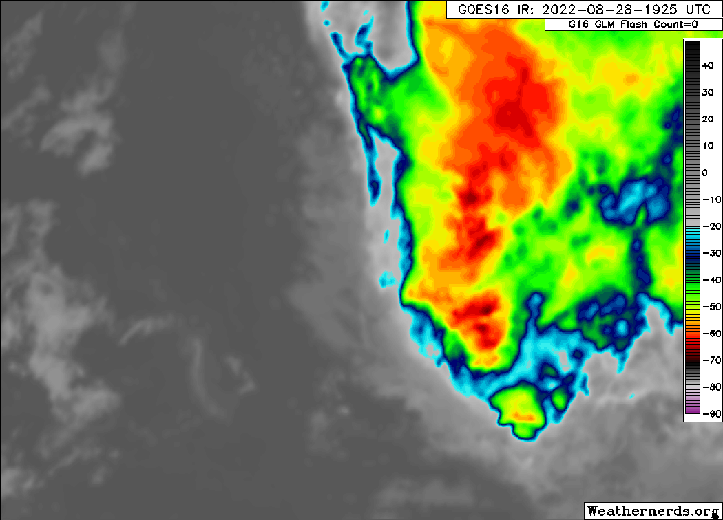
Latest. Convection popping!
2 likes
Hurricane Eye Experience: David 79, Irene 99, Frances 04, Jeanne 04, Wilma 05… Hurricane Brush Experience: Andrew 92, Erin 95, Floyd 99, Matthew 16, Irma 17, Ian 22, Nicole 22…
-
SFLcane

- S2K Supporter
- Posts: 10281
- Age: 48
- Joined: Sat Jun 05, 2010 1:44 pm
- Location: Lake Worth Florida
Re: ATL: INVEST 91L - Discussion
If this one develops I am not getting good vibes for the east coast.
https://twitter.com/andyhazelton/status/1564014915022737413
https://twitter.com/andyhazelton/status/1564014915022737413
0 likes
-
Blown Away
- S2K Supporter
- Posts: 10253
- Joined: Wed May 26, 2004 6:17 am
Re: ATL: INVEST 91L - Discussion
The W moving hurricanes into the Bahamas area almost always have a complicated trough/ridge setup. Majority of SFL impacts, which are near the top % wise in basin turn N before making into the GOM, which in the big picture is a very narrow area. I think the present movement of 91L almost due W will have more to do with potential CONUS impacts down the road than anything else. JMHO
3 likes
Hurricane Eye Experience: David 79, Irene 99, Frances 04, Jeanne 04, Wilma 05… Hurricane Brush Experience: Andrew 92, Erin 95, Floyd 99, Matthew 16, Irma 17, Ian 22, Nicole 22…
Re: ATL: INVEST 91L - Discussion
Blown Away wrote:The W moving hurricanes into the Bahamas area almost always have a complicated trough/ridge setup. Majority of SFL impacts, which are near the top % wise in basin turn N before making into the GOM, which in the big picture is a very narrow area. I think the present movement of 91L almost due W will have more to do with potential CONUS impacts down the road than anything else. JMHO
Dry air intrusion keeps it weak with little propensity to try and recurve but of course now that there is a core structure and enough convection to keep its diurnal pulse it is a serious future threat.
0 likes
-
cycloneye

- Admin

- Posts: 149550
- Age: 69
- Joined: Thu Oct 10, 2002 10:54 am
- Location: San Juan, Puerto Rico
Re: ATL: INVEST 91L - Discussion
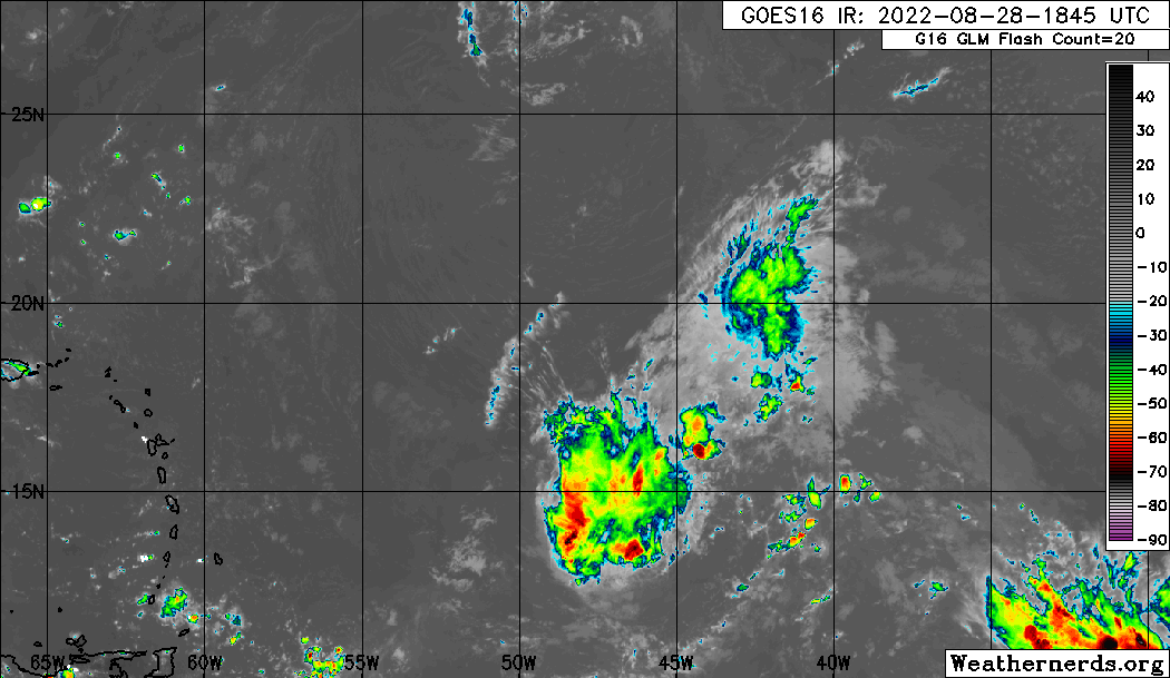
Central Tropical Atlantic:
A broad area of low pressure over the central tropical Atlantic
is producing a large area of disorganized cloudiness and showers.
Although environmental conditions ahead of the system do not appear
conducive for significant development, a tropical depression, at the
very least, is likely to form later this week while the disturbance
moves slowly toward the west and then west-northwest at 5 to 10 mph,
toward the waters east and northeast of the Leeward Islands.
Additional information on this system can be found in high seas
forecasts issued by the National Weather Service.
* Formation chance through 48 hours...medium...50 percent.
* Formation chance through 5 days...high...70 percent.
0 likes
Visit the Caribbean-Central America Weather Thread where you can find at first post web cams,radars
and observations from Caribbean basin members Click Here
and observations from Caribbean basin members Click Here
-
Blown Away
- S2K Supporter
- Posts: 10253
- Joined: Wed May 26, 2004 6:17 am
Re: ATL: INVEST 91L - Discussion
Nimbus wrote:Blown Away wrote:The W moving hurricanes into the Bahamas area almost always have a complicated trough/ridge setup. Majority of SFL impacts, which are near the top % wise in basin turn N before making into the GOM, which in the big picture is a very narrow area. I think the present movement of 91L almost due W will have more to do with potential CONUS impacts down the road than anything else. JMHO
Dry air intrusion keeps it weak with little propensity to try and recurve but of course now that there is a core structure and enough convection to keep its diurnal pulse it is a serious future threat.
Persistent systems sometimes have a tendency to avoid negative conditions regardless of modeling. IMO, in the MDR shallow systems tend to adjust W to avoid.
0 likes
Hurricane Eye Experience: David 79, Irene 99, Frances 04, Jeanne 04, Wilma 05… Hurricane Brush Experience: Andrew 92, Erin 95, Floyd 99, Matthew 16, Irma 17, Ian 22, Nicole 22…
-
Category5Kaiju

- Category 5
- Posts: 4338
- Joined: Thu Dec 24, 2020 12:45 pm
- Location: Seattle during the summer, Phoenix during the winter
Re: ATL: INVEST 91L - Discussion
So is this system trying to correct more west?
0 likes
Unless explicitly stated, all information in my posts is based on my own opinions and observations. Tropical storms and hurricanes can be extremely dangerous. Refer to an accredited weather research agency or meteorologist if you need to make serious decisions regarding an approaching storm.
-
Iceresistance
- Category 5
- Posts: 9598
- Age: 22
- Joined: Sat Oct 10, 2020 9:45 am
- Location: Tecumseh, OK/Norman, OK
Re: ATL: INVEST 91L - Discussion
cycloneye wrote:Central Tropical Atlantic:
A broad area of low pressure over the central tropical Atlantic
is producing a large area of disorganized cloudiness and showers.
Although environmental conditions ahead of the system do not appear
conducive for significant development, a tropical depression, at the
very least, is likely to form later this week while the disturbance
moves slowly toward the west and then west-northwest at 5 to 10 mph,
toward the waters east and northeast of the Leeward Islands.
Additional information on this system can be found in high seas
forecasts issued by the National Weather Service.
* Formation chance through 48 hours...medium...50 percent.
* Formation chance through 5 days...high...70 percent.
50/70 . . .
Well, this is likely to become Danielle in the next several days.
0 likes
Bill 2015 & Beta 2020
Winter 2020-2021
All observations are in Tecumseh, OK unless otherwise noted.
Winter posts are focused mainly for Oklahoma & Texas.
Take any of my forecasts with a grain of salt, refer to the NWS, SPC, and NHC for official information
Never say Never with weather! Because ANYTHING is possible!
Winter 2020-2021
All observations are in Tecumseh, OK unless otherwise noted.
Winter posts are focused mainly for Oklahoma & Texas.
Take any of my forecasts with a grain of salt, refer to the NWS, SPC, and NHC for official information
Never say Never with weather! Because ANYTHING is possible!
-
DestinHurricane

- Category 4

- Posts: 935
- Joined: Tue May 01, 2018 8:05 am
- Location: New York, NY
Re: ATL: INVEST 91L - Discussion
Category5Kaiju wrote:So is this system trying to correct more west?
I'm not sure but the convection consolidated to the SW and we aren't seeing any "reformations" to the north which sometimes happen.
0 likes
Michael 2018

Re: ATL: INVEST 91L - Discussion
WAIT?! A (practically) naked swirl, still heading due west? Ah-ha! Maybe 91L IS actually our GFS phantom Gulf hurricane. Very very coy, GFS 
6 likes
Andy D
(For official information, please refer to the NHC and NWS products.)
(For official information, please refer to the NHC and NWS products.)
Re: ATL: INVEST 91L - Discussion
skyline385 wrote:Blown Away wrote:Nearly all the hurricanes that impact SFL from the E will have to come in S of 25N/70-75W to make it. Nearly all above those marks will miss, 12z ECMWF was N of those marks so recurve away from SFL likely.
Well 12Z ECMWF was actually very similar to the 1947 FLL cane which was the one exception to what you said above.
There are more exceptions than just 1947.
1 likes
-
DestinHurricane
- Category 4
- Posts: 935
- Joined: Tue May 01, 2018 8:05 am
- Location: New York, NY
Re: ATL: INVEST 91L - Discussion
sma10 wrote:skyline385 wrote:Blown Away wrote:Nearly all the hurricanes that impact SFL from the E will have to come in S of 25N/70-75W to make it. Nearly all above those marks will miss, 12z ECMWF was N of those marks so recurve away from SFL likely.
Well 12Z ECMWF was actually very similar to the 1947 FLL cane which was the one exception to what you said above.
There are more exceptions than just 1947.
Yeah, in fact, one with a certain A name.
3 likes
Michael 2018
Re: ATL: INVEST 91L - Discussion
DestinHurricane wrote:sma10 wrote:skyline385 wrote:
Well 12Z ECMWF was actually very similar to the 1947 FLL cane which was the one exception to what you said above.
There are more exceptions than just 1947.
Yeah, in fact, one with a certain A name.
Yes. And Katrina, and Betsy, and 1935 Yankee. Has a lot less to do with coming in under 25N, and more to do with anomalously strong ridging
4 likes
-
cycloneye
- Admin
- Posts: 149550
- Age: 69
- Joined: Thu Oct 10, 2002 10:54 am
- Location: San Juan, Puerto Rico
Re: ATL: INVEST 91L - Discussion
AL, 91, 2022082900, , BEST, 0, 140N, 452W, 30, 1007, DB

3 likes
Visit the Caribbean-Central America Weather Thread where you can find at first post web cams,radars
and observations from Caribbean basin members Click Here
and observations from Caribbean basin members Click Here
-
Spacecoast

- Category 2
- Posts: 773
- Joined: Thu Aug 31, 2017 2:03 pm

Who is online
Users browsing this forum: No registered users and 19 guests