
CPAC: JIMENA - Remnants
Moderator: S2k Moderators
-
Kingarabian

- S2K Supporter

- Posts: 16373
- Joined: Sat Aug 08, 2009 3:06 am
- Location: Honolulu, Hawaii
Re: EPAC: NINE-E - Tropical Depression
Not as pretty as Hilda but it's doing a much better job now in sustaining and increasing convection over its entire envelope.
0 likes
RIP Kobe Bryant
-
Yellow Evan

- Professional-Met

- Posts: 16242
- Age: 27
- Joined: Fri Jul 15, 2011 12:48 pm
- Location: Henderson, Nevada/Honolulu, HI
- Contact:
Re: EPAC: NINE-E - Tropical Depression
Northwesterly shear that was bothering the system seems to have subsided given there's sufficient convection over the center. Recent burst near the NHC center point may suggest its trying to become more stacked.
0 likes
-
Kingarabian
- S2K Supporter
- Posts: 16373
- Joined: Sat Aug 08, 2009 3:06 am
- Location: Honolulu, Hawaii
Re: EPAC: NINE-E - Tropical Depression
18z GFS again shows interaction with Hilda:

1 likes
RIP Kobe Bryant
-
Yellow Evan
- Professional-Met
- Posts: 16242
- Age: 27
- Joined: Fri Jul 15, 2011 12:48 pm
- Location: Henderson, Nevada/Honolulu, HI
- Contact:
Re: EPAC: NINE-E - Tropical Depression
TXPZ28 KNES 310000
TCSENP
A. 09E (NONAME)
B. 30/2330Z
C. 12.3N
D. 126.2W
E. FIVE/GOES-W
F. T1.0/1.5
G. IR/EIR/VIS
H. REMARKS...CIRCULAR CLOUD LINES AROUND AN LLCC THAT IS GREATER THAN
1.25 DEGREES FROM A VERY SMALL COLD OVERCAST MAKES THE DT EQUAL TO
1.0. THE MET AND PT AGREE AND ARE ALSO EQUAL TO 1.0. THE FT IS BASED
ON THE MET DUE TO CLOUD FEATURES THAT ARE NOT CLEAR CUT AND UNCERTAINTY
WITH THE EXACT LLCC POSITION IN SATELLITE IMAGERY.
I. ADDL POSITIONS
NIL
...SAMBUCCI
0 likes
-
Yellow Evan
- Professional-Met
- Posts: 16242
- Age: 27
- Joined: Fri Jul 15, 2011 12:48 pm
- Location: Henderson, Nevada/Honolulu, HI
- Contact:

-
Sciencerocks
- Category 5

- Posts: 10186
- Age: 40
- Joined: Thu Jul 06, 2017 1:51 am

-
DorkyMcDorkface

- Category 5
- Posts: 1027
- Age: 28
- Joined: Mon Sep 30, 2019 1:32 pm
- Location: Mid-Atlantic
Re: EPAC: NINE-E - Tropical Depression
Yellow Evan wrote:https://cdn.discordapp.com/attachments/733552978572869632/870822451305644032/20210730.png
Barely a tropical cyclone.
Combine this with the scattershot convective activity and I personally wouldn't have pulled the trigger for classification just yet. I suppose DMAX could give it a boost.
0 likes
Please note the thoughts expressed by this account are solely those of the user and are from a hobbyist perspective. For more comprehensive analysis, consult an actual professional meteorologist or meteorological agency.
Floyd 1999 | Isabel 2003 | Hanna 2008 | Irene 2011 | Sandy 2012 | Isaias 2020

Re: EPAC: NINE-E - Tropical Depression
This cyclone is like table scraps: trash with barely any substance — in this case, convection.
1 likes
Irene '11 Sandy '12 Hermine '16 5/15/2018 Derecho Fay '20 Isaias '20 Elsa '21 Henri '21 Ida '21
I am only a meteorology enthusiast who knows a decent amount about tropical cyclones. Look to the professional mets, the NHC, or your local weather office for the best information.
I am only a meteorology enthusiast who knows a decent amount about tropical cyclones. Look to the professional mets, the NHC, or your local weather office for the best information.
-
cycloneye

- Admin

- Posts: 149550
- Age: 69
- Joined: Thu Oct 10, 2002 10:54 am
- Location: San Juan, Puerto Rico
Re: EPAC: NINE-E - Tropical Depression
EP, 09, 2021073100, , BEST, 0, 125N, 1260W, 25, 1007, TD
0 likes
Visit the Caribbean-Central America Weather Thread where you can find at first post web cams,radars
and observations from Caribbean basin members Click Here
and observations from Caribbean basin members Click Here
-
Yellow Evan
- Professional-Met
- Posts: 16242
- Age: 27
- Joined: Fri Jul 15, 2011 12:48 pm
- Location: Henderson, Nevada/Honolulu, HI
- Contact:
Re: EPAC: NINE-E - Tropical Depression

Look at how close Hilda is to 09E. Considering the lack of convection with 09E and that Hilda is moving much faster than 09E, it’s possible 09E doesn’t survive. Door probably opens for intensification into a hurricane if Hilda doesn’t absorb it, however.
0 likes
-
Kingarabian
- S2K Supporter
- Posts: 16373
- Joined: Sat Aug 08, 2009 3:06 am
- Location: Honolulu, Hawaii
Re: EPAC: NINE-E - Tropical Depression
18z Euro keeps this weak for a while but eventually intensifies it.
0 likes
RIP Kobe Bryant
-
Yellow Evan
- Professional-Met
- Posts: 16242
- Age: 27
- Joined: Fri Jul 15, 2011 12:48 pm
- Location: Henderson, Nevada/Honolulu, HI
- Contact:
Re: EPAC: NINE-E - Tropical Depression

18z GFS still interacts this with Hilda with this being absorbed by Hilda but still somehow wants to deepen this some.
1 likes
-
cycloneye
- Admin
- Posts: 149550
- Age: 69
- Joined: Thu Oct 10, 2002 10:54 am
- Location: San Juan, Puerto Rico
Re: EPAC: NINE-E - Tropical Depression
Tropical Depression Nine-E Discussion Number 2
NWS National Hurricane Center Miami FL EP092021
800 PM PDT Fri Jul 30 2021
The depression is struggling. Aside from a stray cell or two, the
cyclone has been nearly devoid of deep convection since the diurnal
convective minimum earlier this evening. AMSR data near 22Z
indicated that multiple weak swirls may be embedded within the
broader circulation sampled earlier today by ASCAT. The initial
intensity remains 25 kt for this advisory.
Confidence in the track forecast is unusually low. The initial
position, and therefore also the motion estimate, is highly
uncertain due to the disorganized nature of the depression. On top
of that, the track guidance is in extremely poor agreement regarding
even the basics of the future track of the cyclone. Hilda, located
relatively close to the east (about 10 degrees) may have some impact
on the depression's track during the next 5 days. In fact, the GFS
explicitly forecasts that a binary interaction will occur between
the two tropical cyclones. Other models like the ECMWF move both
systems steadily, and mostly independently, westward. As a course of
least regret, the NHC track forecast is close to the previous
advisory and multi-model consensus, between those two scenarios.
Large changes to the track forecast may be necessary on Saturday if
the track guidance begins to converge on a single solution.
Warm water and moderate shear could allow for some strengthening
during the next few days, if the depression can redevelop and
sustain organized convection. The NHC intensity forecast assumes
that will happen to some degree and has not been substantially
changed. It is also possible that dry air in the environment could
continue to inhibit convection as the depression moves westward.
In that case, the official intensity forecast could wind up being a
little too high. The NHC intensity forecast is well within the
guidance envelope, but is a touch above the latest consensus.
FORECAST POSITIONS AND MAX WINDS
INIT 31/0300Z 12.5N 126.2W 25 KT 30 MPH
12H 31/1200Z 12.4N 126.6W 30 KT 35 MPH
24H 01/0000Z 12.3N 127.3W 30 KT 35 MPH
36H 01/1200Z 12.4N 128.4W 35 KT 40 MPH
48H 02/0000Z 12.7N 130.0W 35 KT 40 MPH
60H 02/1200Z 13.1N 131.6W 35 KT 40 MPH
72H 03/0000Z 13.4N 133.0W 40 KT 45 MPH
96H 04/0000Z 13.8N 135.9W 45 KT 50 MPH
120H 05/0000Z 14.5N 138.9W 50 KT 60 MPH
$$
Forecaster Zelinsky
0 likes
Visit the Caribbean-Central America Weather Thread where you can find at first post web cams,radars
and observations from Caribbean basin members Click Here
and observations from Caribbean basin members Click Here
-
Kingarabian
- S2K Supporter
- Posts: 16373
- Joined: Sat Aug 08, 2009 3:06 am
- Location: Honolulu, Hawaii
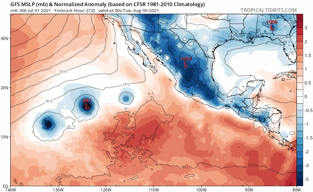
Re: EPAC: NINE-E - Tropical Depression
00z GFS continuing the binary interaction with Hilda:
1 likes
RIP Kobe Bryant
-
Kingarabian
- S2K Supporter
- Posts: 16373
- Joined: Sat Aug 08, 2009 3:06 am
- Location: Honolulu, Hawaii
Re: EPAC: NINE-E - Tropical Depression
00z Euro, CMC keep this away from Hilda and eventually track it south of Hawaii.
00z UKMET lifts this well NE of Hawaii.
00z CMC ensembles that are stronger show this going north of Hawaii.

00z UKMET lifts this well NE of Hawaii.
00z CMC ensembles that are stronger show this going north of Hawaii.
0 likes
RIP Kobe Bryant
-
Kingarabian
- S2K Supporter
- Posts: 16373
- Joined: Sat Aug 08, 2009 3:06 am
- Location: Honolulu, Hawaii
Re: EPAC: NINE-E - Tropical Depression
SAB discontinuing it for now:

TXPZ28 KNES 310549
TCSENP
A. 09E (NONAME)
B. 31/0530Z
C. 12.1N
D. 126.6W
E. FIVE/GOES-W
F. TOO WEAK
G. IR/EIR/SWIR
H. REMARKS...THIS SYSTEM IS TOO WEAK TO CLASSIFY DUE TO A LACK OF
PERSISTENT CONVECTION NEAR A LLCC THAT IS NOT WELL DEFINED IN RECENT
SATELLITE IMAGERY. THIS WILL BE THE FINAL BULLETIN FOR THIS SYSTEM
UNLESS PERSISTENT CONVECTION AROUND A WELL DEFINED LLCC OCCURS IN FUTURE
SATELLITE IMAGERY.
I. ADDL POSITIONS
NIL
...SAMBUCCI
0 likes
RIP Kobe Bryant
-
cycloneye
- Admin
- Posts: 149550
- Age: 69
- Joined: Thu Oct 10, 2002 10:54 am
- Location: San Juan, Puerto Rico
Re: EPAC: NINE-E - Tropical Depression
Tropical Depression Nine-E Discussion Number 3
NWS National Hurricane Center Miami FL EP092021
200 AM PDT Sat Jul 31 2021
The depression remains poorly organized this morning. Deep
convection remains limited, and recent scatterometer data show that
the circulation is elongated from east to west. The initial
intensity is maintained at 25 kt, which could be generous based on
the latest ASCAT data.
As mentioned in the previous advisory, the confidence in the track
and intensity forecast for the depression is quite low due to the
current lack of organization of the system, and the potential for
some interaction with Tropical Storm Hilda located to its
northeast. The ASCAT data was helpful in pinpointing the center
location overnight, and the latest fixes indicate that the cyclone
is moving just south of due west or 265/5 kt. The track guidance
generally agrees on a slow west or west-southwest heading over the
next 12-24 hours followed by a west or west-northwest motion
through 48-60 hours. After that time, the track guidance begins to
diverge with the GFS showing a binary interaction of the depression
and Hilda by days 4 and 5. Most of the remainder of the guidance
keeps enough separation between the systems that the depression
continues generally moving westward or west-northwestward through
the end of the forecast period. The NHC track forecast is once
again close to the various multi-model consensus aids, and is
slightly slower than the previous official forecast.
Although the depression is located over warm water, moderate
easterly shear and dry air entrainment have prevented strengthening
since genesis occurred. Given the current poor organization of the
system and the marginal environment, only slow strengthening is
indicated over the next few days. Another plausible scenario is
that the system fails to produce organization deep convection
within the next 12 to 24 hours, and it degenerates into a broad low
pressure area along the ITCZ. Given this uncertainty, the NHC
intensity forecast has been lowered slightly and is in best
agreement with the IVCN intensity aid.
FORECAST POSITIONS AND MAX WINDS
INIT 31/0900Z 12.3N 127.0W 25 KT 30 MPH
12H 31/1800Z 12.2N 127.5W 25 KT 30 MPH
24H 01/0600Z 12.1N 128.3W 30 KT 35 MPH
36H 01/1800Z 12.2N 129.6W 30 KT 35 MPH
48H 02/0600Z 12.5N 131.3W 35 KT 40 MPH
60H 02/1800Z 12.8N 132.8W 35 KT 40 MPH
72H 03/0600Z 13.1N 134.2W 40 KT 45 MPH
96H 04/0600Z 13.7N 136.5W 45 KT 50 MPH
120H 05/0600Z 14.5N 138.5W 45 KT 50 MPH
$$
Forecaster Brown
0 likes
Visit the Caribbean-Central America Weather Thread where you can find at first post web cams,radars
and observations from Caribbean basin members Click Here
and observations from Caribbean basin members Click Here
-
Yellow Evan
- Professional-Met
- Posts: 16242
- Age: 27
- Joined: Fri Jul 15, 2011 12:48 pm
- Location: Henderson, Nevada/Honolulu, HI
- Contact:
Re: EPAC: NINE-E - Tropical Depression
This is no longer a tropical cyclone. We’ll see if this can make a comeback but this is clearly a trough.
0 likes
-
cycloneye
- Admin
- Posts: 149550
- Age: 69
- Joined: Thu Oct 10, 2002 10:54 am
- Location: San Juan, Puerto Rico
Re: EPAC: NINE-E - Tropical Depression
Tropical Depression Nine-E Discussion Number 4
NWS National Hurricane Center Miami FL EP092021
800 AM PDT Sat Jul 31 2021
The depression has become increasingly elongated west-to-east since
the previous advisory. Although deep convection has increased
somewhat near the center, with cloud tops now colder than -70C, the
convection isn't organized very well. The initial intensity is being
maintained at 25 kt until new ASCAT data arrives this afternoon.
The initial motion estimate is 270/04 kt. The latest NHC track
guidance is in decent agreement on the depression moving in a slow
westward direction for the next 24 hours or so, followed by a
west-northwestward motion as the ridge to north of the cyclone
weakens slightly. By around 72 hours, some binary interaction
between the depression and rapidly strengthening Tropical Storm
Hilda, located about 650 nmi to the east, is expected. However, the
degree of interaction varies widely among the models. The GFS is the
most extreme and takes the depression northward on days 4 and 5,
with the ECMWF being the weakest, showing little if any interaction
and keeps the cyclone moving generally westward through 120 h; the
other global and regional models lie somewhere in between these two
extremes. For now, the new official NHC track forecast was only
nudged slightly northward, and lies inside the southern edge of the
guidance envelope near the TVCE consensus model.
The depression's future intensity and existence depends heavily on
the track over the next 5 days. A more westward motion would keep
the cyclone over warmer water and in a better upper-level flow
regime. In contrast, a sharp northward motion, as per the GFS
solution, would place the system over colder water and within strong
vertical wind shear. Another negative factor is the effect of
intensifying Hilda to the east, which has started to draw in the
southerly/southwesterly cross-equatorial inflow away from TD-9E.
This deflection of the low-level flow eastward away from the
depression could result in the cyclone's cyclone getting stretched
out/elongated east-to-west even further, which would induce
weakening or even dissipation of the cyclone. For now, the previous
intensity forecast is being maintained for this advisory until the
track model guidance comes into better agreement, and the
interactive effects of Tropical Storm Hilda become clearer.
FORECAST POSITIONS AND MAX WINDS
INIT 31/1500Z 12.1N 127.6W 25 KT 30 MPH
12H 01/0000Z 12.1N 128.2W 25 KT 30 MPH
24H 01/1200Z 12.1N 129.2W 30 KT 35 MPH
36H 02/0000Z 12.3N 130.7W 30 KT 35 MPH
48H 02/1200Z 12.5N 132.3W 35 KT 40 MPH
60H 03/0000Z 12.8N 133.7W 35 KT 40 MPH
72H 03/1200Z 13.1N 135.0W 40 KT 45 MPH
96H 04/1200Z 13.8N 137.2W 45 KT 50 MPH
120H 05/1200Z 15.5N 139.9W 45 KT 50 MPH
$$
Forecaster Stewart
0 likes
Visit the Caribbean-Central America Weather Thread where you can find at first post web cams,radars
and observations from Caribbean basin members Click Here
and observations from Caribbean basin members Click Here
-
Sciencerocks
- Category 5
- Posts: 10186
- Age: 40
- Joined: Thu Jul 06, 2017 1:51 am

Who is online
Users browsing this forum: No registered users and 18 guests