EPAC: CARLOS - Remnants

Moderator: S2k Moderators

Message
Author
User avatar
Yellow Evan
Professional-Met
Professional-Met
Posts: 15960
Age: 25
Joined: Fri Jul 15, 2011 12:48 pm
Location: Henderson, Nevada/Honolulu, HI
Contact:

Re: EPAC: INVEST 92E

#81 Postby Yellow Evan » Sun Jun 06, 2021 7:46 pm

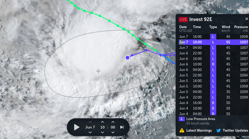
Yellow Evan wrote:Classifiable at this point as long as it can sustain itself.


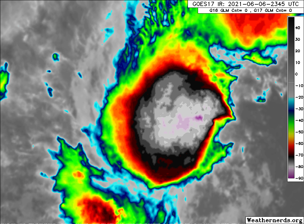
Take that back. Still not convinced this has a well defined center.
0 likes   

User avatar
Kingarabian
S2K Supporter
S2K Supporter
Posts: 15461
Joined: Sat Aug 08, 2009 3:06 am
Location: Honolulu, Hawaii

Re: EPAC: INVEST 92E

#82 Postby Kingarabian » Sun Jun 06, 2021 7:51 pm

:uarrow: If recon was in it they probably would find one. It's a pretty small system being hit with shear. So a true consistent LLC is going to be tough to see on satellite imagery or ASCAT. No problem sustaining deep convection for the past 36 hours.

Image
1 likes   
RIP Kobe Bryant

User avatar
Kingarabian
S2K Supporter
S2K Supporter
Posts: 15461
Joined: Sat Aug 08, 2009 3:06 am
Location: Honolulu, Hawaii

Re: EPAC: INVEST 92E

#83 Postby Kingarabian » Sun Jun 06, 2021 7:55 pm

TXPZ21 KNES 070044
TCSENP

A. TROPICAL DISTURBANCE (92E)

B. 06/2330Z

C. 13.2N

D. 108.8W

E. FIVE/GOES-W

F. T2.0/2.0

G. IR/EIR/VIS/AMSR2

H. REMARKS...SYSTEM IS CHARACTERIZED BY SPIRAL LOOSELY-DEFINED CLOUD
LINES AND A LLCC LESS THAN 1.25 DEG FROM A LARGE COLD OVC RESULTING IN
A DT OF 1.5. MET AND PT=2.0. FT IS BASED ON MET DUE TO LLCC NOT CLR-CUT
AND PSBL MULTIPLE LLCC.


I. ADDL POSITIONS

06/2048Z 12.9N 108.7E AMSR2


...KONON


EP, 92, 2021060700, , BEST, 0, 129N, 1095W, 30, 1007, LO
0 likes   
RIP Kobe Bryant

Sciencerocks
Category 5
Category 5
Posts: 7300
Age: 38
Joined: Thu Jul 06, 2017 1:51 am

Re: EPAC: INVEST 92E

#84 Postby Sciencerocks » Sun Jun 06, 2021 9:47 pm

Image
0 likes   

JW-_-
Category 1
Category 1
Posts: 281
Joined: Thu Mar 04, 2021 4:46 pm

Re: EPAC: INVEST 92E

#85 Postby JW-_- » Sun Jun 06, 2021 10:12 pm

The center looks a tad elongated but there is one recognizable on the sat pic.

Image
3 likes   

User avatar
Kingarabian
S2K Supporter
S2K Supporter
Posts: 15461
Joined: Sat Aug 08, 2009 3:06 am
Location: Honolulu, Hawaii

Re: EPAC: INVEST 92E

#86 Postby Kingarabian » Sun Jun 06, 2021 11:38 pm

Hour old GMI pass:
Image
0 likes   
RIP Kobe Bryant

User avatar
galaxy401
Category 5
Category 5
Posts: 2300
Age: 29
Joined: Sat Aug 25, 2012 9:04 pm
Location: Casa Grande, Arizona

Re: EPAC: INVEST 92E

#87 Postby galaxy401 » Mon Jun 07, 2021 12:22 am

Looks like a Tropical Depression to me but it looks like time is running out for this system to get upgraded.
1 likes   
Got my eyes on moving right into Hurricane Alley: Florida.

JW-_-
Category 1
Category 1
Posts: 281
Joined: Thu Mar 04, 2021 4:46 pm

Re: EPAC: INVEST 92E

#88 Postby JW-_- » Mon Jun 07, 2021 12:26 am

Image

Image

Think maybe now the ship has sailed. Back @ 00z tho, it did likely meet the classification requirements wind-wise.
1 likes   

User avatar
Kingarabian
S2K Supporter
S2K Supporter
Posts: 15461
Joined: Sat Aug 08, 2009 3:06 am
Location: Honolulu, Hawaii

Re: EPAC: INVEST 92E

#89 Postby Kingarabian » Mon Jun 07, 2021 2:07 am

90/90 and no classification. What was this phenomenon if it was never a TC at any point?
0 likes   
RIP Kobe Bryant

JW-_-
Category 1
Category 1
Posts: 281
Joined: Thu Mar 04, 2021 4:46 pm

Re: EPAC: INVEST 92E

#90 Postby JW-_- » Mon Jun 07, 2021 5:00 am

Image

The fluid model showed the vortex quite well. Not uncommon for the vortex to relocate as it
was doing @ times inside a td. Taking the maximum wind field into account on the earlier micro wind image I agree with you guys who were in favor. :ggreen:
0 likes   

JW-_-
Category 1
Category 1
Posts: 281
Joined: Thu Mar 04, 2021 4:46 pm

Re: EPAC: INVEST 92E

#91 Postby JW-_- » Mon Jun 07, 2021 6:16 am

Image

Comparision @ 55kmh with 1007mb

Image

Image
0 likes   

User avatar
cycloneye
Admin
Admin
Posts: 139593
Age: 67
Joined: Thu Oct 10, 2002 10:54 am
Location: San Juan, Puerto Rico

Re: EPAC: INVEST 92E

#92 Postby cycloneye » Mon Jun 07, 2021 7:12 am

Down to 60%.

Showers and thunderstorms continue in association with an area of
low pressure located about 400 miles south-southeast of Socorro
Island. However, the system still lacks a well-defined center, as
recent satellite imagery indicates the low-level circulation remains
broad and displaced well east of the thunderstorm activity. The
disturbance still has the potential to become a short-lived tropical
depression today before environmental conditions become less
favorable for development by tonight. The system is forecast to
move slowly west-southwestward during the next couple of days.
* Formation chance through 48 hours...medium...60 percent.
* Formation chance through 5 days...medium...60 percent.
0 likes   
Visit the Caribbean-Central America Weather Thread where you can find at first post web cams,radars
and observations from Caribbean basin members Click Here

User avatar
ElectricStorm
Category 5
Category 5
Posts: 4623
Age: 23
Joined: Tue Aug 13, 2019 11:23 pm
Location: Skiatook, OK / Norman, OK

Re: EPAC: INVEST 92E

#93 Postby ElectricStorm » Mon Jun 07, 2021 7:30 am

I thought this for sure was going to be classified at some point but it doesn't look like it
0 likes   
I am in no way a professional. Take what I say with a grain of salt as I could be totally wrong. Please refer to the NHC, NWS, or SPC for official information.

Boomer Sooner!

Sciencerocks
Category 5
Category 5
Posts: 7300
Age: 38
Joined: Thu Jul 06, 2017 1:51 am

Re: EPAC: INVEST 92E

#94 Postby Sciencerocks » Mon Jun 07, 2021 10:14 am

Image
0 likes   

User avatar
cycloneye
Admin
Admin
Posts: 139593
Age: 67
Joined: Thu Oct 10, 2002 10:54 am
Location: San Juan, Puerto Rico

Re: EPAC: INVEST 92E

#95 Postby cycloneye » Mon Jun 07, 2021 6:20 pm

Bye.

Showers and thunderstorms continue to become less organized in
association with a broad area of low pressure located about 700
miles south of the southern tip of the Baja California peninsula.
Environmental conditions are expected to become increasingly
unfavorable, and development of this system is now unlikely. The
disturbance is forecast to move slowly west-southwestward during the
next couple of days.
* Formation chance through 48 hours...low...30 percent.
* Formation chance through 5 days...low...30 percent.
0 likes   
Visit the Caribbean-Central America Weather Thread where you can find at first post web cams,radars
and observations from Caribbean basin members Click Here

User avatar
Yellow Evan
Professional-Met
Professional-Met
Posts: 15960
Age: 25
Joined: Fri Jul 15, 2011 12:48 pm
Location: Henderson, Nevada/Honolulu, HI
Contact:

Re: EPAC: INVEST 92E

#96 Postby Yellow Evan » Mon Jun 07, 2021 6:50 pm

0 likes   

JW-_-
Category 1
Category 1
Posts: 281
Joined: Thu Mar 04, 2021 4:46 pm

Re: EPAC: INVEST 92E

#97 Postby JW-_- » Mon Jun 07, 2021 7:54 pm

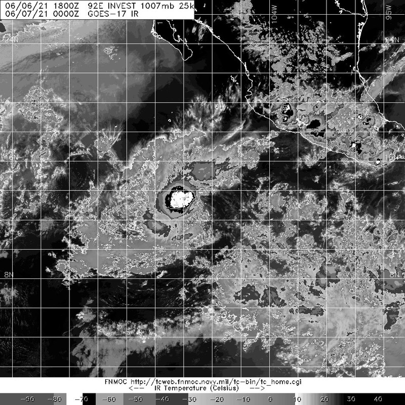
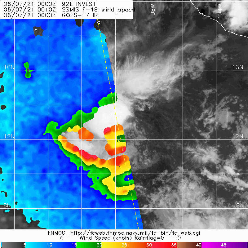
Kingarabian wrote:90/90 and no classification. What was this phenomenon if it was never a TC at any point?


Small weakish monsoon depression.
1 likes   

Sciencerocks
Category 5
Category 5
Posts: 7300
Age: 38
Joined: Thu Jul 06, 2017 1:51 am

Re: EPAC: INVEST 92E

#98 Postby Sciencerocks » Mon Jun 07, 2021 7:57 pm

Image
0 likes   

User avatar
Hurricaneman
Category 5
Category 5
Posts: 7284
Age: 43
Joined: Tue Aug 31, 2004 3:24 pm
Location: central florida

Re: EPAC: INVEST 92E

#99 Postby Hurricaneman » Tue Jun 08, 2021 12:06 am

It's dead but did seem to be a depression at one point
1 likes   

User avatar
cycloneye
Admin
Admin
Posts: 139593
Age: 67
Joined: Thu Oct 10, 2002 10:54 am
Location: San Juan, Puerto Rico

Re: EPAC: INVEST 92E

#100 Postby cycloneye » Tue Jun 08, 2021 6:52 am

A broad area of low pressure located about 700 miles south of the
southern tip of the Baja California peninsula is producing limited
shower and thunderstorm activity well west of its center.
Significant development of this system is not expected due to strong
upper-level winds and dry air in the surrounding environment. The
disturbance is forecast to move slowly west-southwestward during the
next couple of days.
* Formation chance through 48 hours...low...near 0 percent.
* Formation chance through 5 days...low...near 0 percent.
0 likes   
Visit the Caribbean-Central America Weather Thread where you can find at first post web cams,radars
and observations from Caribbean basin members Click Here


Return to “2021”

Who is online

Users browsing this forum: No registered users and 3 guests