

AF recon finding plenty of TS force winds and a closed circulation, time for upgrade back to TS Grace.
URNT15 KNHC 161202
AF302 0607A GRACE HDOB 24 20210816
115300 1727N 07011W 9250 00772 0107 +210 +125 148032 033 036 000 03
115330 1727N 07013W 9250 00772 0107 +207 +132 148033 033 036 000 00
115400 1727N 07016W 9248 00774 0107 +206 +130 149033 034 036 000 00
115430 1728N 07018W 9249 00773 0107 +207 +130 151034 034 036 000 00
115500 1728N 07020W 9255 00770 0108 +206 +137 152035 035 035 000 00
115530 1728N 07022W 9261 00762 0106 +208 +121 150035 036 036 001 00
115600 1728N 07024W 9246 00774 0107 +202 +115 152035 036 036 000 03
115630 1728N 07026W 9253 00769 0108 +203 +118 152036 037 035 001 00
115700 1728N 07027W 9246 00775 0109 +200 +116 154035 036 035 001 00
115730 1728N 07029W 9254 00768 0110 +201 +113 158035 035 038 004 03
115800 1728N 07031W 9239 00781 0112 +190 +117 157034 037 037 009 00
115830 1729N 07033W 9272 00747 0114 +174 +117 158036 038 055 043 03
115900 1729N 07035W 9246 00773 0115 +172 +109 173037 038 051 027 00
115930 1729N 07036W 9241 00774 0111 +173 +103 182030 038 048 024 03
120000 1729N 07038W 9248 00766 0108 +174 +099 179022 025 046 038 03
120030 1729N 07039W 9243 00769 0106 +176 +098 176019 021 047 038 03
120100 1729N 07041W 9262 00752 0100 +197 +102 185012 015 035 009 00
120130 1729N 07043W 9248 00762 0095 +205 +097 215009 009 027 002 00
120200 1729N 07044W 9261 00749 0093 +206 +100 223008 008 027 000 03
120230 1730N 07046W 9249 00758 0088 +213 +103 265007 009 029 000 00
$$
ATL: GRACE - Remnants - Discussion
Moderator: S2k Moderators

Re: ATL: GRACE - Tropical Depression - Discussion
NDG wrote:AF recon finding plenty of TS force winds and a closed circulation, time for upgrade back to TS Grace.
URNT15 KNHC 161202
AF302 0607A GRACE HDOB 24 20210816
115300 1727N 07011W 9250 00772 0107 +210 +125 148032 033 036 000 03
115330 1727N 07013W 9250 00772 0107 +207 +132 148033 033 036 000 00
115400 1727N 07016W 9248 00774 0107 +206 +130 149033 034 036 000 00
115430 1728N 07018W 9249 00773 0107 +207 +130 151034 034 036 000 00
115500 1728N 07020W 9255 00770 0108 +206 +137 152035 035 035 000 00
115530 1728N 07022W 9261 00762 0106 +208 +121 150035 036 036 001 00
115600 1728N 07024W 9246 00774 0107 +202 +115 152035 036 036 000 03
115630 1728N 07026W 9253 00769 0108 +203 +118 152036 037 035 001 00
115700 1728N 07027W 9246 00775 0109 +200 +116 154035 036 035 001 00
115730 1728N 07029W 9254 00768 0110 +201 +113 158035 035 038 004 03
115800 1728N 07031W 9239 00781 0112 +190 +117 157034 037 037 009 00
115830 1729N 07033W 9272 00747 0114 +174 +117 158036 038 055 043 03
115900 1729N 07035W 9246 00773 0115 +172 +109 173037 038 051 027 00
115930 1729N 07036W 9241 00774 0111 +173 +103 182030 038 048 024 03
120000 1729N 07038W 9248 00766 0108 +174 +099 179022 025 046 038 03
120030 1729N 07039W 9243 00769 0106 +176 +098 176019 021 047 038 03
120100 1729N 07041W 9262 00752 0100 +197 +102 185012 015 035 009 00
120130 1729N 07043W 9248 00762 0095 +205 +097 215009 009 027 002 00
120200 1729N 07044W 9261 00749 0093 +206 +100 223008 008 027 000 03
120230 1730N 07046W 9249 00758 0088 +213 +103 265007 009 029 000 00
$$
SFMR are up to 50-55 kt but look to be very rain-inflated. Based on FL winds, 35-40 kt looks good for 11am. The center is less than 0.1 degrees north of the last fix, suggesting that Grace could miss Haiti altogether, and the NHC will have to adjust the track further south.
0 likes
Irene '11 Sandy '12 Hermine '16 5/15/2018 Derecho Fay '20 Isaias '20 Elsa '21 Henri '21 Ida '21
I am only a meteorology enthusiast who knows a decent amount about tropical cyclones. Look to the professional mets, the NHC, or your local weather office for the best information.
I am only a meteorology enthusiast who knows a decent amount about tropical cyclones. Look to the professional mets, the NHC, or your local weather office for the best information.
-
Hypercane_Kyle

- Category 5

- Posts: 3465
- Joined: Sat Mar 07, 2015 7:58 pm
- Location: Cape Canaveral, FL
Re: ATL: GRACE - Tropical Depression - Discussion
Entire page with SFMR of >40 knots, so I think it's pretty safe to say that Grace is back to TS status. MSLP looks around 1007 mb.
0 likes
My posts are my own personal opinion, defer to the National Hurricane Center (NHC) and other NOAA products for decision making during hurricane season.
Re: ATL: GRACE - Tropical Depression - Discussion
Looking at the forecasted environment for Grace in a more southerly track, I think it will be a good candidate to become the first MH in the Atlantic Basin. Bad news for Mexico.
2 likes
-
Shell Mound
- Category 5
- Posts: 2432
- Age: 33
- Joined: Thu Sep 07, 2017 3:39 pm
- Location: St. Petersburg, FL → Scandinavia
Re: ATL: GRACE - Tropical Depression - Discussion
Hypercane_Kyle wrote:Entire page with SFMR of >40 knots, so I think it's pretty safe to say that Grace is back to TS status. MSLP looks around 1007 mb.
FL winds don’t support TS status thus far. Given SFMR’s record of inflation, I think Grace is still a depression. Surface observations don’t support TS winds.
0 likes
CVW / MiamiensisWx / Shell Mound
The posts in this forum are NOT official forecasts and should not be used as such. They are just the opinion of the poster and may or may not be backed by sound meteorological data. They are NOT endorsed by any professional institution or STORM2K. For official information, please refer to products from the NHC and NWS.
-
Hypercane_Kyle
- Category 5
- Posts: 3465
- Joined: Sat Mar 07, 2015 7:58 pm
- Location: Cape Canaveral, FL
Re: ATL: GRACE - Tropical Depression - Discussion
Shell Mound wrote:Hypercane_Kyle wrote:Entire page with SFMR of >40 knots, so I think it's pretty safe to say that Grace is back to TS status. MSLP looks around 1007 mb.
FL winds don’t support TS status thus far. Given SFMR’s record of inflation, I think Grace is still a depression. Surface observations don’t support TS winds.
True, could be due to close proximity to land that is high-biasing the SFMR.
1 likes
My posts are my own personal opinion, defer to the National Hurricane Center (NHC) and other NOAA products for decision making during hurricane season.
-
ScottNAtlanta

- Category 5
- Posts: 2535
- Joined: Sat May 25, 2013 3:11 pm
- Location: Atlanta, GA
Re: ATL: GRACE - Tropical Depression - Discussion
If anything, Hispaniola will finally knock out that persistent northern center from messing with the southern one.
1 likes
The posts in this forum are NOT official forecast and should not be used as such. They are just the opinion of the poster and may or may not be backed by sound meteorological data. They are NOT endorsed by any professional institution or storm2k.org. For official information, please refer to the NHC and NWS products.

Re: ATL: GRACE - Tropical Depression - Discussion
AlphaToOmega wrote:The NHC cone takes this right over Haiti.
https://i.postimg.cc/PJz4mRJT/084856-5day-cone-no-line-and-wind.png
As it relates to the track of Grace, this is exactly what Weatherman57 predicted would happen a few days ago, prior to the official forecast track change. Nice to have a resident expert on here!
2 likes
Any forecast I make is based on my opinion only. Please refer to the NWS or NHC for official forecasts.

Re: ATL: GRACE - Tropical Depression - Discussion
I'm not gonna post the same image in every thread, but in the Fred thread I showed the current MPI of storms in the GOM and the entire region that Grace is about to enter has sub-900 MPI's. She has been through a lot, but the reduced shear (less than 5 kts near Yucatan) together with the very high MPI makes me worried that Grace could truly make a run to a strong hurricane, possibly even a major as someone has already pointed out.
Of course the immediate threat is to Haiti where precisely the areas affected by the earthquake are getting 200+ mm of rain the coming days.

Of course the immediate threat is to Haiti where precisely the areas affected by the earthquake are getting 200+ mm of rain the coming days.
2 likes
-
Hypercane_Kyle
- Category 5
- Posts: 3465
- Joined: Sat Mar 07, 2015 7:58 pm
- Location: Cape Canaveral, FL
Re: ATL: GRACE - Tropical Depression - Discussion
I'd be surprised if the NHC doesn't up the peak intensity a bit at 11am.

0 likes
My posts are my own personal opinion, defer to the National Hurricane Center (NHC) and other NOAA products for decision making during hurricane season.

Re: ATL: GRACE - Tropical Depression - Discussion
Reminiscent of Ike?
0 likes
Alicia, Rita, Ike, Harvey and Beryl...moved to Splendora lol
-
UTSARoadrunner4
- Category 1

- Posts: 265
- Age: 29
- Joined: Wed Aug 26, 2020 11:19 pm
Re: ATL: GRACE - Tropical Depression - Discussion
mpic wrote:Reminiscent of Ike?
In what way? Track wise Grace seems like it may follow the footsteps of heavy hitters Dean & Gilbert.I don’t think it’ll get to the intensity of them though. With that being said, Hurricane Dean and TD Grace have eerily similar timelines.
0 likes
Re: ATL: GRACE - Tropical Depression - Discussion
I just remember predictions of a Mexico hit with a last minute turn north and being thankful that I found this forum and didn't listen to the tv
EDIT: Of course, we have much better technology now.
EDIT: Of course, we have much better technology now.
Last edited by mpic on Mon Aug 16, 2021 8:55 am, edited 1 time in total.
1 likes
Alicia, Rita, Ike, Harvey and Beryl...moved to Splendora lol
-
cycloneye

- Admin

- Posts: 149571
- Age: 69
- Joined: Thu Oct 10, 2002 10:54 am
- Location: San Juan, Puerto Rico
Re: ATL: GRACE - Tropical Depression - Discussion
0 likes
Visit the Caribbean-Central America Weather Thread where you can find at first post web cams,radars
and observations from Caribbean basin members Click Here
and observations from Caribbean basin members Click Here
Re: ATL: GRACE - Tropical Depression - Discussion
cycloneye wrote:https://twitter.com/webberweather/status/1427262172573233158
Looks like it’ll miss the southern tip of DR and possibly Haiti too, but it’s very close so any shifts can cause disruption.
0 likes
Irene '11 Sandy '12 Hermine '16 5/15/2018 Derecho Fay '20 Isaias '20 Elsa '21 Henri '21 Ida '21
I am only a meteorology enthusiast who knows a decent amount about tropical cyclones. Look to the professional mets, the NHC, or your local weather office for the best information.
I am only a meteorology enthusiast who knows a decent amount about tropical cyclones. Look to the professional mets, the NHC, or your local weather office for the best information.
Re: ATL: GRACE - Tropical Depression - Discussion
aspen wrote:Grace’s “center” should’ve been put at around 16.0-16.5N. There’s nothing at 17.0N.
This is reminding me a bit of Harvey during its initial trek through the Caribbean.
Perish the thought....but as we all know we gotta be vigilant and maintain awareness...which I did not do with Harvey..I won't ever make that mistake again...
0 likes
Re: ATL: GRACE - Tropical Depression - Discussion
I read in an earlier local discussion that makes mention of drier air in the Central/West Gulf?...I wonder will that keep the system at a lower potential for any intensification, if the system survives that long?
0 likes
-
ElectricStorm

- Category 5
- Posts: 5148
- Age: 25
- Joined: Tue Aug 13, 2019 11:23 pm
- Location: Norman, OK
Re: ATL: GRACE - Tropical Depression - Discussion
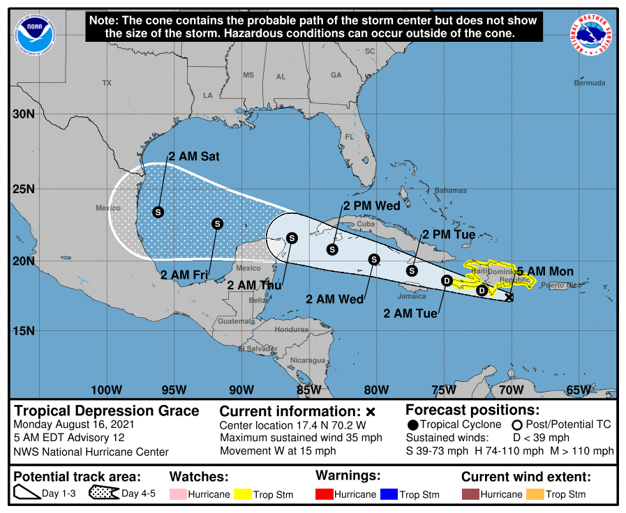
BULLETIN
Tropical Depression Grace Advisory Number 13
NWS National Hurricane Center Miami FL AL072021
1100 AM EDT Mon Aug 16 2021
...CENTER OF GRACE JUST ABOUT TO CROSS THE BARAHONA PENINSULA OF
THE DOMINICAN REPUBLIC...
...FLASH FLOODING AND MUDSLIDES POSSIBLE ACROSS THE DOMINICAN
REPUBLIC AND HAITI TODAY...
SUMMARY OF 1100 AM EDT...1500 UTC...INFORMATION
-----------------------------------------------
LOCATION...17.7N 71.4W
ABOUT 85 MI...140 KM SE OF PORT AU PRINCE HAITI
ABOUT 430 MI...690 KM E OF MONTEGO BAY JAMAICA
MAXIMUM SUSTAINED WINDS...35 MPH...55 KM/H
PRESENT MOVEMENT...W OR 280 DEGREES AT 15 MPH...24 KM/H
MINIMUM CENTRAL PRESSURE...1007 MB...29.74 INCHES
0 likes
B.S Meteorology, University of Oklahoma '25
Please refer to the NHC, NWS, or SPC for official information.
Please refer to the NHC, NWS, or SPC for official information.

Re: ATL: GRACE - Tropical Depression - Discussion
[youtube]https://youtu.be/a6O69sE5nGE[/youtube]
0 likes

Re: ATL: GRACE - Tropical Depression - Discussion
Massive lightning from the tower just offshore and almost on top of the quake devastation zone.
Prayers for the people.
Prayers for the people.
3 likes
Who is online
Users browsing this forum: No registered users and 62 guests