EPAC: CARLOS - Remnants

Moderator: S2k Moderators

Message
Author
User avatar
Kingarabian
S2K Supporter
S2K Supporter
Posts: 15462
Joined: Sat Aug 08, 2009 3:06 am
Location: Honolulu, Hawaii

Re: EPAC: INVEST 92E

#61 Postby Kingarabian » Sun Jun 06, 2021 12:41 am

Tropical Weather Outlook
NWS National Hurricane Center Miami FL
1100 PM PDT Sat Jun 5 2021

For the eastern North Pacific...east of 140 degrees west longitude:

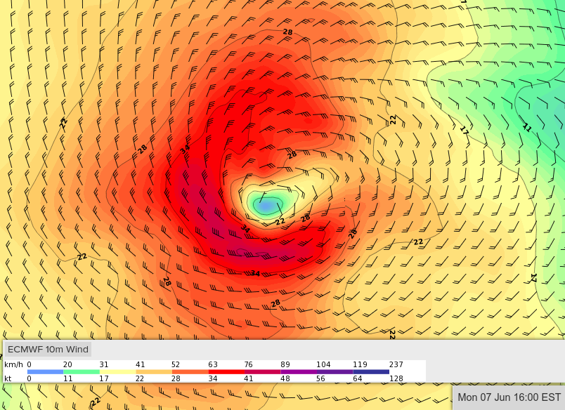
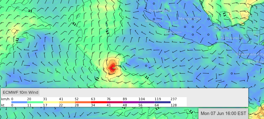
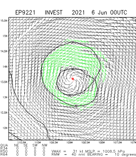
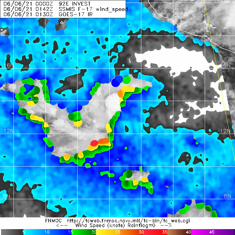
1. Showers and thunderstorms have become better organized during the
past few hours in association with an area of low pressure located
about 450 miles south-southwest of Manzanillo, Mexico. In addition,
satellite images suggest that the low-level circulation is gradually
becoming better defined. This system will likely become a tropical
depression on Sunday while it moves slowly westward. Environmental
conditions are expected to become less conducive for additional
development in a couple of days.
* Formation chance through 48 hours...high...90 percent.
* Formation chance through 5 days...high...90percent.


00z HWRF develops it again but only as a 50kt TC.
Last edited by Kingarabian on Sun Jun 06, 2021 1:11 am, edited 1 time in total.
0 likes   
RIP Kobe Bryant

JW-_-
Category 1
Category 1
Posts: 281
Joined: Thu Mar 04, 2021 4:46 pm

Re: EPAC: INVEST 92E

#62 Postby JW-_- » Sun Jun 06, 2021 12:51 am

Image
Image
1 likes   

User avatar
Kingarabian
S2K Supporter
S2K Supporter
Posts: 15462
Joined: Sat Aug 08, 2009 3:06 am
Location: Honolulu, Hawaii

Re: EPAC: INVEST 92E

#63 Postby Kingarabian » Sun Jun 06, 2021 1:09 am

SAB up to 2.0.
TXPZ21 KNES 060553
TCSENP

A. TROPICAL DISTURBANCE (92E)

B. 06/0530Z

C. 13.4N

D. 108.1W

E. THREE/GOES-W

F. T2.0/2.0

G. IR/EIR/SWIR

H. REMARKS...3/10 WHITE BANING AROUND LLCC YIELDS DT OF 2.0. MET IS
1.5 AND PT IS 2.0. FT IS BASED ON DT.

I. ADDL POSITIONS

NIL


...MLEVINE
0 likes   
RIP Kobe Bryant

JW-_-
Category 1
Category 1
Posts: 281
Joined: Thu Mar 04, 2021 4:46 pm

Re: EPAC: INVEST 92E

#64 Postby JW-_- » Sun Jun 06, 2021 1:35 am

Image

Subjective but meets td classification viva amsu.

..................................................................................................................

Image
1 likes   

User avatar
cycloneye
Admin
Admin
Posts: 139722
Age: 67
Joined: Thu Oct 10, 2002 10:54 am
Location: San Juan, Puerto Rico

Re: EPAC: INVEST 92E

#65 Postby cycloneye » Sun Jun 06, 2021 6:43 am

Showers and thunderstorms associated with an area of low pressure
located several hundred miles south-southwest of Manzanillo, Mexico
continue to show increasing signs of organization. This system will
likely become a tropical depression later today or tonight while it
moves slowly westward. Environmental conditions are expected to
become less conducive for additional development in a couple of
days.
* Formation chance through 48 hours...high...90 percent.
* Formation chance through 5 days...high...90 percent.
0 likes   
Visit the Caribbean-Central America Weather Thread where you can find at first post web cams,radars
and observations from Caribbean basin members Click Here

User avatar
cycloneye
Admin
Admin
Posts: 139722
Age: 67
Joined: Thu Oct 10, 2002 10:54 am
Location: San Juan, Puerto Rico

Re: EPAC: INVEST 92E

#66 Postby cycloneye » Sun Jun 06, 2021 12:03 pm

12z GFS has nothing.
0 likes   
Visit the Caribbean-Central America Weather Thread where you can find at first post web cams,radars
and observations from Caribbean basin members Click Here

User avatar
Yellow Evan
Professional-Met
Professional-Met
Posts: 15960
Age: 25
Joined: Fri Jul 15, 2011 12:48 pm
Location: Henderson, Nevada/Honolulu, HI
Contact:

Re: EPAC: INVEST 92E

#67 Postby Yellow Evan » Sun Jun 06, 2021 12:37 pm

Looks more broad than I would like and it has a terrible moisture envelope. NHC should lower development chances due to this as well as a lack of model support.
0 likes   

User avatar
aspen
Category 5
Category 5
Posts: 8061
Joined: Sat Oct 12, 2019 7:10 pm
Location: Connecticut, USA

Re: EPAC: INVEST 92E

#68 Postby aspen » Sun Jun 06, 2021 12:52 pm

Yellow Evan wrote:Looks more broad than I would like and it has a terrible moisture envelope. NHC should lower development chances due to this as well as a lack of model support.

That’s a stark contrast to model runs not even two days old showing a good moisture envelope, decently quick development, and a small core.
0 likes   
Irene '11 Sandy '12 Hermine '16 5/15/2018 Derecho Fay '20 Isaias '20 Elsa '21 Henri '21 Ida '21

I am only a meteorology enthusiast who knows a decent amount about tropical cyclones. Look to the professional mets, the NHC, or your local weather office for the best information.

User avatar
cycloneye
Admin
Admin
Posts: 139722
Age: 67
Joined: Thu Oct 10, 2002 10:54 am
Location: San Juan, Puerto Rico

Re: EPAC: INVEST 92E

#69 Postby cycloneye » Sun Jun 06, 2021 12:56 pm

Satellite imagery indicates that an area of low pressure located
several hundred miles south-southwest of Manzanillo, Mexico is
producing an organized area of showers and thunderstorms and could
be developing a better-defined surface circulation. This system
will likely become a tropical depression by tonight while it moves
slowly westward. Upper-level winds are expected to become less
favorable for additional development in a couple of days.
* Formation chance through 48 hours...high...90 percent.
* Formation chance through 5 days...high...90 percent.
0 likes   
Visit the Caribbean-Central America Weather Thread where you can find at first post web cams,radars
and observations from Caribbean basin members Click Here

User avatar
Kingarabian
S2K Supporter
S2K Supporter
Posts: 15462
Joined: Sat Aug 08, 2009 3:06 am
Location: Honolulu, Hawaii

Re: EPAC: INVEST 92E

#70 Postby Kingarabian » Sun Jun 06, 2021 1:24 pm

The models since yesterday have been poofing this for 3 model cycles now and this has consistently maintained convection. IMO this has been a TD for the past 24 hours regardless of imperfections in LLC structure that ASCAT shows.
0 likes   
RIP Kobe Bryant

User avatar
Yellow Evan
Professional-Met
Professional-Met
Posts: 15960
Age: 25
Joined: Fri Jul 15, 2011 12:48 pm
Location: Henderson, Nevada/Honolulu, HI
Contact:

Re: EPAC: INVEST 92E

#71 Postby Yellow Evan » Sun Jun 06, 2021 1:29 pm

06/1730 UTC 13.3N 108.5W T2.0/2.0 92E -- East Pacific
0 likes   

Sciencerocks
Category 5
Category 5
Posts: 7318
Age: 38
Joined: Thu Jul 06, 2017 1:51 am

Re: EPAC: INVEST 92E

#72 Postby Sciencerocks » Sun Jun 06, 2021 1:48 pm

Image

Image
0 likes   

User avatar
Kingarabian
S2K Supporter
S2K Supporter
Posts: 15462
Joined: Sat Aug 08, 2009 3:06 am
Location: Honolulu, Hawaii

Re: EPAC: INVEST 92E

#73 Postby Kingarabian » Sun Jun 06, 2021 3:31 pm

What appears to be coming out from the east is midshear primarily located to the S/SSW of it, appears to be close enough and is impacting the system. The deeper convection is outpacing the LLC on visible imagery. That being said it's increasingly looking like it warrants a classification. It has had persistent deep convection near the center and the center is clear as day on visible imagery.

Image
Last edited by Kingarabian on Sun Jun 06, 2021 3:43 pm, edited 1 time in total.
1 likes   
RIP Kobe Bryant

User avatar
ElectricStorm
Category 5
Category 5
Posts: 4627
Age: 23
Joined: Tue Aug 13, 2019 11:23 pm
Location: Skiatook, OK / Norman, OK

Re: EPAC: INVEST 92E

#74 Postby ElectricStorm » Sun Jun 06, 2021 3:33 pm

Should see a TD or a weak TS out of this, but not much more than that imo
0 likes   
I am in no way a professional. Take what I say with a grain of salt as I could be totally wrong. Please refer to the NHC, NWS, or SPC for official information.

Boomer Sooner!

User avatar
Kingarabian
S2K Supporter
S2K Supporter
Posts: 15462
Joined: Sat Aug 08, 2009 3:06 am
Location: Honolulu, Hawaii

Re: EPAC: INVEST 92E

#75 Postby Kingarabian » Sun Jun 06, 2021 4:15 pm

This GMI pass taken about 5 hours ago:
Image

With this visible at that time:
Image
0 likes   
RIP Kobe Bryant

User avatar
Yellow Evan
Professional-Met
Professional-Met
Posts: 15960
Age: 25
Joined: Fri Jul 15, 2011 12:48 pm
Location: Henderson, Nevada/Honolulu, HI
Contact:

Re: EPAC: INVEST 92E

#76 Postby Yellow Evan » Sun Jun 06, 2021 5:16 pm

Classifiable at this point as long as it can sustain itself.
0 likes   

User avatar
Kingarabian
S2K Supporter
S2K Supporter
Posts: 15462
Joined: Sat Aug 08, 2009 3:06 am
Location: Honolulu, Hawaii

Re: EPAC: INVEST 92E

#77 Postby Kingarabian » Sun Jun 06, 2021 5:25 pm

Burst of convection:
Image
0 likes   
RIP Kobe Bryant

User avatar
Kingarabian
S2K Supporter
S2K Supporter
Posts: 15462
Joined: Sat Aug 08, 2009 3:06 am
Location: Honolulu, Hawaii

Re: EPAC: INVEST 92E

#78 Postby Kingarabian » Sun Jun 06, 2021 6:30 pm

NHC starting to lose interest. Down from 90/90.

Tropical Weather Outlook
NWS National Hurricane Center Miami FL
500 PM PDT Sun Jun 6 2021

For the eastern North Pacific...east of 140 degrees west longitude:

1. Showers and thunderstorms continue in association with an area of
low pressure located about 500 miles south-southwest of Manzanillo,
Mexico. However, the circulation of the system remains broad and
elongated and it still lacks a well-defined center. Development of
this system into a short-lived tropical depression is still likely
before environmental conditions become less favorable by late
Monday. The low pressure area is expected to move slowly westward
well south of Mexico during the next few days.
* Formation chance through 48 hours...high...80 percent.
* Formation chance through 5 days...high...80 percent.


How does a system with some banding features, persistent convection, a low level center (well defined or not) and a Dvorak reading of 2.0 not be classified?
0 likes   
RIP Kobe Bryant

User avatar
aspen
Category 5
Category 5
Posts: 8061
Joined: Sat Oct 12, 2019 7:10 pm
Location: Connecticut, USA

Re: EPAC: INVEST 92E

#79 Postby aspen » Sun Jun 06, 2021 6:49 pm

Looks like a TD to me. Convection has been persistent since last night. Imagine if this never gets classified.
1 likes   
Irene '11 Sandy '12 Hermine '16 5/15/2018 Derecho Fay '20 Isaias '20 Elsa '21 Henri '21 Ida '21

I am only a meteorology enthusiast who knows a decent amount about tropical cyclones. Look to the professional mets, the NHC, or your local weather office for the best information.

JW-_-
Category 1
Category 1
Posts: 281
Joined: Thu Mar 04, 2021 4:46 pm

Re: EPAC: INVEST 92E

#80 Postby JW-_- » Sun Jun 06, 2021 7:01 pm

Without recon, they can be trigger shy with marginal systems @ birth.
1 likes   


Return to “2021”

Who is online

Users browsing this forum: No registered users and 4 guests