ATL: LARRY - Post-Tropical - Discussion
Moderator: S2k Moderators
-
Yellow Evan

- Professional-Met

- Posts: 16242
- Age: 27
- Joined: Fri Jul 15, 2011 12:48 pm
- Location: Henderson, Nevada/Honolulu, HI
- Contact:
Re: ATL: LARRY - Hurricane - Discussion
This looks like Iselle 14 in the Pacific. Same annularish structure and eye shape.
1 likes
-
Yellow Evan
- Professional-Met
- Posts: 16242
- Age: 27
- Joined: Fri Jul 15, 2011 12:48 pm
- Location: Henderson, Nevada/Honolulu, HI
- Contact:

-
Sciencerocks
- Category 5

- Posts: 10186
- Age: 40
- Joined: Thu Jul 06, 2017 1:51 am

-
Kingarabian

- S2K Supporter

- Posts: 16373
- Joined: Sat Aug 08, 2009 3:06 am
- Location: Honolulu, Hawaii
-
Kingarabian
- S2K Supporter
- Posts: 16373
- Joined: Sat Aug 08, 2009 3:06 am
- Location: Honolulu, Hawaii
Re: ATL: LARRY - Hurricane - Discussion
* GFS version *
* ATLANTIC 2021 SHIPS INTENSITY FORECAST *
* IR SAT DATA AVAILABLE, OHC AVAILABLE *
* LARRY AL122021 09/05/21 06 UTC *
TIME (HR) 0 6 12 18 24 36 48 60 72 84 96 108 120 132 144 156 168
V (KT) NO LAND 105 103 102 100 99 95 95 94 96 99 99 101 95 90 85 72 52
V (KT) LAND 105 103 102 100 99 95 95 94 96 99 99 101 95 90 85 72 52
V (KT) LGEM 105 102 99 97 96 94 95 99 103 105 105 101 94 88 69 53 45
Storm Type TROP TROP TROP TROP TROP TROP TROP TROP TROP TROP TROP TROP TROP TROP EXTP EXTP EXTP
SHEAR (KT) 8 9 9 11 9 6 7 7 9 7 5 12 18 20 34 25 38
SHEAR ADJ (KT) 0 -2 -1 -1 2 3 3 2 -3 0 1 -1 -1 10 10 -1 7
SHEAR DIR 252 252 254 261 277 291 271 283 283 192 137 188 223 223 209 182 202
SST (C) 27.5 27.6 27.8 27.9 27.9 28.0 29.1 29.2 29.5 29.3 29.0 28.2 27.8 25.2 17.5 13.1 11.0
This hasn't peaked at all. More to come. This has all the ingredients to get to Cat.5. Recon should also be in around its peak just incase Dvorak pulls a choke job.
0 likes
RIP Kobe Bryant

Re: ATL: LARRY - Hurricane - Discussion
Kingarabian wrote:* GFS version *
* ATLANTIC 2021 SHIPS INTENSITY FORECAST *
* IR SAT DATA AVAILABLE, OHC AVAILABLE *
* LARRY AL122021 09/05/21 06 UTC *
TIME (HR) 0 6 12 18 24 36 48 60 72 84 96 108 120 132 144 156 168
V (KT) NO LAND 105 103 102 100 99 95 95 94 96 99 99 101 95 90 85 72 52
V (KT) LAND 105 103 102 100 99 95 95 94 96 99 99 101 95 90 85 72 52
V (KT) LGEM 105 102 99 97 96 94 95 99 103 105 105 101 94 88 69 53 45
Storm Type TROP TROP TROP TROP TROP TROP TROP TROP TROP TROP TROP TROP TROP TROP EXTP EXTP EXTP
SHEAR (KT) 8 9 9 11 9 6 7 7 9 7 5 12 18 20 34 25 38
SHEAR ADJ (KT) 0 -2 -1 -1 2 3 3 2 -3 0 1 -1 -1 10 10 -1 7
SHEAR DIR 252 252 254 261 277 291 271 283 283 192 137 188 223 223 209 182 202
SST (C) 27.5 27.6 27.8 27.9 27.9 28.0 29.1 29.2 29.5 29.3 29.0 28.2 27.8 25.2 17.5 13.1 11.0
This hasn't peaked at all. More to come. This has all the ingredients to get to Cat.5. Recon should also be in around its peak just incase Dvorak pulls a choke job.
Do you also have the the shear forecast according to the Euro? Since the NHC discussion mentions that GFS and the euro still differ quite a bit in terms of their shear forecast during the next 48 hours (where euro shows more shear).
0 likes
-
Kingarabian
- S2K Supporter
- Posts: 16373
- Joined: Sat Aug 08, 2009 3:06 am
- Location: Honolulu, Hawaii
Re: ATL: LARRY - Hurricane - Discussion
kevin wrote:Kingarabian wrote:* GFS version *
* ATLANTIC 2021 SHIPS INTENSITY FORECAST *
* IR SAT DATA AVAILABLE, OHC AVAILABLE *
* LARRY AL122021 09/05/21 06 UTC *
TIME (HR) 0 6 12 18 24 36 48 60 72 84 96 108 120 132 144 156 168
V (KT) NO LAND 105 103 102 100 99 95 95 94 96 99 99 101 95 90 85 72 52
V (KT) LAND 105 103 102 100 99 95 95 94 96 99 99 101 95 90 85 72 52
V (KT) LGEM 105 102 99 97 96 94 95 99 103 105 105 101 94 88 69 53 45
Storm Type TROP TROP TROP TROP TROP TROP TROP TROP TROP TROP TROP TROP TROP TROP EXTP EXTP EXTP
SHEAR (KT) 8 9 9 11 9 6 7 7 9 7 5 12 18 20 34 25 38
SHEAR ADJ (KT) 0 -2 -1 -1 2 3 3 2 -3 0 1 -1 -1 10 10 -1 7
SHEAR DIR 252 252 254 261 277 291 271 283 283 192 137 188 223 223 209 182 202
SST (C) 27.5 27.6 27.8 27.9 27.9 28.0 29.1 29.2 29.5 29.3 29.0 28.2 27.8 25.2 17.5 13.1 11.0
This hasn't peaked at all. More to come. This has all the ingredients to get to Cat.5. Recon should also be in around its peak just incase Dvorak pulls a choke job.
Do you also have the the shear forecast according to the Euro? Since the NHC discussion mentions that GFS and the euro still differ quite a bit in terms of their shear forecast during the next 48 hours (where euro shows more shear).
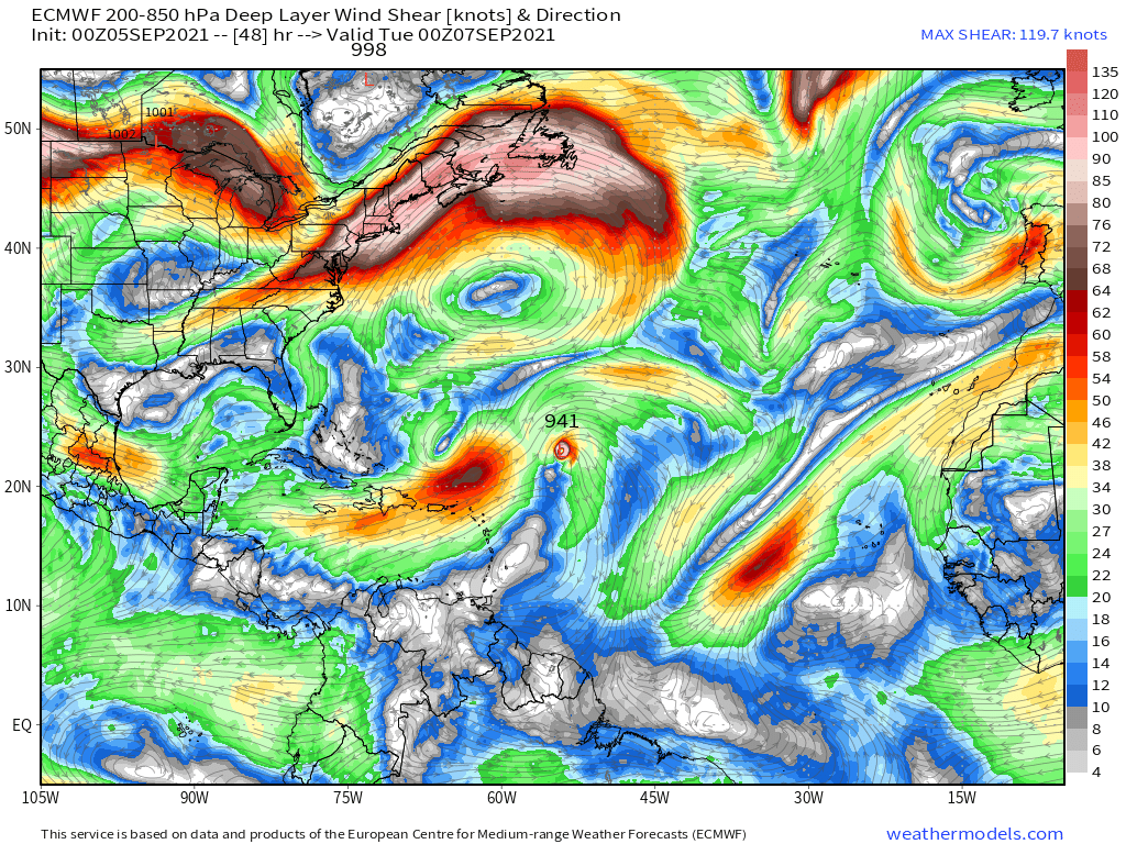
Very similar shear from what I can see. Could argue the Euro has less shear over the next 48 hours compared to the GFS. The Euro is more bullish on this compared to the GFS.
GFS:
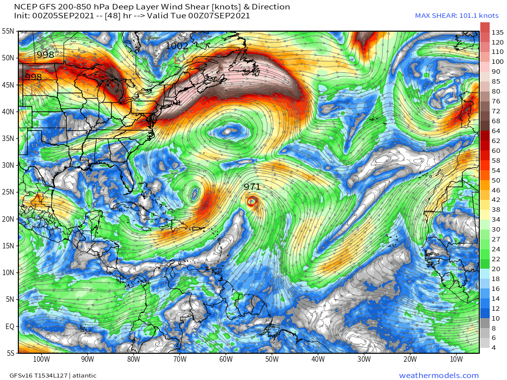
Euro:
1 likes
RIP Kobe Bryant
Re: ATL: LARRY - Hurricane - Discussion
Kingarabian wrote:kevin wrote:Kingarabian wrote:* GFS version *
* ATLANTIC 2021 SHIPS INTENSITY FORECAST *
* IR SAT DATA AVAILABLE, OHC AVAILABLE *
* LARRY AL122021 09/05/21 06 UTC *
TIME (HR) 0 6 12 18 24 36 48 60 72 84 96 108 120 132 144 156 168
V (KT) NO LAND 105 103 102 100 99 95 95 94 96 99 99 101 95 90 85 72 52
V (KT) LAND 105 103 102 100 99 95 95 94 96 99 99 101 95 90 85 72 52
V (KT) LGEM 105 102 99 97 96 94 95 99 103 105 105 101 94 88 69 53 45
Storm Type TROP TROP TROP TROP TROP TROP TROP TROP TROP TROP TROP TROP TROP TROP EXTP EXTP EXTP
SHEAR (KT) 8 9 9 11 9 6 7 7 9 7 5 12 18 20 34 25 38
SHEAR ADJ (KT) 0 -2 -1 -1 2 3 3 2 -3 0 1 -1 -1 10 10 -1 7
SHEAR DIR 252 252 254 261 277 291 271 283 283 192 137 188 223 223 209 182 202
SST (C) 27.5 27.6 27.8 27.9 27.9 28.0 29.1 29.2 29.5 29.3 29.0 28.2 27.8 25.2 17.5 13.1 11.0
This hasn't peaked at all. More to come. This has all the ingredients to get to Cat.5. Recon should also be in around its peak just incase Dvorak pulls a choke job.
Do you also have the the shear forecast according to the Euro? Since the NHC discussion mentions that GFS and the euro still differ quite a bit in terms of their shear forecast during the next 48 hours (where euro shows more shear).
Very similar shear from what I can see. Could argue the Euro has less shear over the next 48 hours compared to the GFS. The Euro is more bullish on this compared to the GFS.
GFS:
https://i.postimg.cc/vZj8Trk8/image.png
Euro:
https://i.postimg.cc/qvt0PtRP/image.png
Thanks, will be interesting to see what happens with Larry. The NHC's latest discussion (already 6 hours ago by now) was also still a bit conflicted about Larry's future:
The GFS keeps the shear over Larry fairly low since it's farther from
the trough, while the ECMWF increases the shear to moderate or
strong levels during the next 48 hours. If Larry reaches the area
of stronger shear, its intensity would obviously be adversely
affected. In terms of structure, significant re-intensification is
now less likely since Larry has such a large eye and an expanding
wind field. On the positive side, the hurricane will be moving
over gradually warmer waters for the next 3 days or so. Given
these conflicting factors, the updated NHC intensity forecast allows
for some slight restrengthening in the short term but then keeps
Larry's intensity steady for the next 3 days. Many of the intensity
models are even lower than what's shown in this forecast, so
additional adjustments may be required in future advisories.
0 likes
-
Kingarabian
- S2K Supporter
- Posts: 16373
- Joined: Sat Aug 08, 2009 3:06 am
- Location: Honolulu, Hawaii
Re: ATL: LARRY - Hurricane - Discussion
kevin wrote:Kingarabian wrote:kevin wrote:
Do you also have the the shear forecast according to the Euro? Since the NHC discussion mentions that GFS and the euro still differ quite a bit in terms of their shear forecast during the next 48 hours (where euro shows more shear).
Very similar shear from what I can see. Could argue the Euro has less shear over the next 48 hours compared to the GFS. The Euro is more bullish on this compared to the GFS.
GFS:
https://i.postimg.cc/vZj8Trk8/image.png
Euro:
https://i.postimg.cc/qvt0PtRP/image.png
Thanks, will be interesting to see what happens with Larry. The NHC's latest discussion (already 6 hours ago by now) was also still a bit conflicted about Larry's future:The GFS keeps the shear over Larry fairly low since it's farther from
the trough, while the ECMWF increases the shear to moderate or
strong levels during the next 48 hours. If Larry reaches the area
of stronger shear, its intensity would obviously be adversely
affected. In terms of structure, significant re-intensification is
now less likely since Larry has such a large eye and an expanding
wind field. On the positive side, the hurricane will be moving
over gradually warmer waters for the next 3 days or so. Given
these conflicting factors, the updated NHC intensity forecast allows
for some slight restrengthening in the short term but then keeps
Larry's intensity steady for the next 3 days. Many of the intensity
models are even lower than what's shown in this forecast, so
additional adjustments may be required in future advisories.
Yeah I don't know what runs they're looking at here. I think Berg is mixing up the model solutions. The Euro is showing this much stronger than the GFS over the next 48 hours.
Euro has this @ 107kts in 48 hours while the GFS is only 84kts.
1 likes
RIP Kobe Bryant
-
Kingarabian
- S2K Supporter
- Posts: 16373
- Joined: Sat Aug 08, 2009 3:06 am
- Location: Honolulu, Hawaii
Re: ATL: LARRY - Hurricane - Discussion
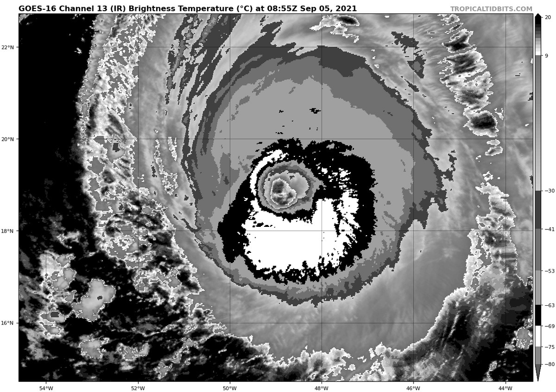
Could wrap a W ring soon and maybe qualify for a T6.5 if it smoothes out.
0 likes
RIP Kobe Bryant
Re: ATL: LARRY - Hurricane - Discussion
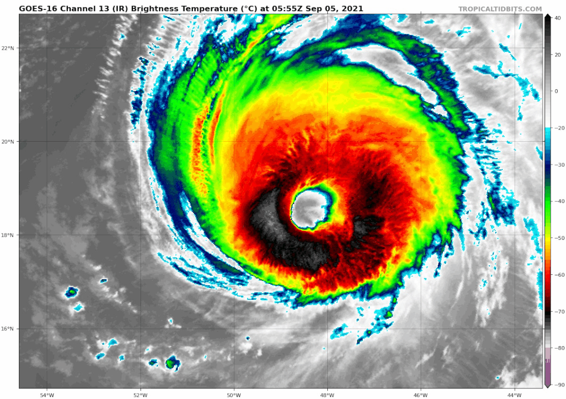
Almost a perfectly circular eye, Dvorak should like this.

4 likes

Re: ATL: LARRY - Hurricane - Discussion
Wow, that’s one hell of an eye. Convection is significantly deeper than last night, so 105 kt might be low.
0 likes
Irene '11 Sandy '12 Hermine '16 5/15/2018 Derecho Fay '20 Isaias '20 Elsa '21 Henri '21 Ida '21
I am only a meteorology enthusiast who knows a decent amount about tropical cyclones. Look to the professional mets, the NHC, or your local weather office for the best information.
I am only a meteorology enthusiast who knows a decent amount about tropical cyclones. Look to the professional mets, the NHC, or your local weather office for the best information.
Re: ATL: LARRY - Hurricane - Discussion
Kingarabian wrote:* GFS version *
* ATLANTIC 2021 SHIPS INTENSITY FORECAST *
* IR SAT DATA AVAILABLE, OHC AVAILABLE *
* LARRY AL122021 09/05/21 06 UTC *
TIME (HR) 0 6 12 18 24 36 48 60 72 84 96 108 120 132 144 156 168
V (KT) NO LAND 105 103 102 100 99 95 95 94 96 99 99 101 95 90 85 72 52
V (KT) LAND 105 103 102 100 99 95 95 94 96 99 99 101 95 90 85 72 52
V (KT) LGEM 105 102 99 97 96 94 95 99 103 105 105 101 94 88 69 53 45
Storm Type TROP TROP TROP TROP TROP TROP TROP TROP TROP TROP TROP TROP TROP TROP EXTP EXTP EXTP
SHEAR (KT) 8 9 9 11 9 6 7 7 9 7 5 12 18 20 34 25 38
SHEAR ADJ (KT) 0 -2 -1 -1 2 3 3 2 -3 0 1 -1 -1 10 10 -1 7
SHEAR DIR 252 252 254 261 277 291 271 283 283 192 137 188 223 223 209 182 202
SST (C) 27.5 27.6 27.8 27.9 27.9 28.0 29.1 29.2 29.5 29.3 29.0 28.2 27.8 25.2 17.5 13.1 11.0
This hasn't peaked at all. More to come. This has all the ingredients to get to Cat.5. Recon should also be in around its peak just incase Dvorak pulls a choke job.
The HWRF is still showing the upper-level environment becoming better on Monday and Tuesday, when it’ll be moving over some of the warmest water and highest OHC of its journey. Recon will also be going out on Tuesday. Larry has a good chance of peaking then, and I believe it will be a 120-125 kt Cat 4, although a Cat 5 seems to be too much.
2 likes
Irene '11 Sandy '12 Hermine '16 5/15/2018 Derecho Fay '20 Isaias '20 Elsa '21 Henri '21 Ida '21
I am only a meteorology enthusiast who knows a decent amount about tropical cyclones. Look to the professional mets, the NHC, or your local weather office for the best information.
I am only a meteorology enthusiast who knows a decent amount about tropical cyclones. Look to the professional mets, the NHC, or your local weather office for the best information.

-
cheezyWXguy

- Category 5
- Posts: 6282
- Joined: Mon Feb 13, 2006 12:29 am
- Location: Dallas, TX
Re: ATL: LARRY - Hurricane - Discussion
Is the angle of the satellite distorting things, or is Larry really as tilted to the east with height as he looks?
0 likes
-
beoumont

- Category 1

- Posts: 473
- Joined: Sun Jul 10, 2011 4:13 pm
- Location: East Central Florida
- Contact:
Re: ATL: LARRY - Hurricane - Discussion
cheezyWXguy wrote:Is the angle of the satellite distorting things, or is Larry really as tilted to the east with height as he looks?
Maybe this can at least partially answer your query.
From the 5 am NHC discussion:
<<<<<However, recent
AMSR2 microwave data indicate that the vortex is still well-aligned
vertically, with a pronounced eyewall that slopes outward with
height>>>>
The angle of the rising sun bouncing off the west wall might also be a factor in your perception of the structure.
0 likes
List of 79 tropical cyclones intercepted by Richard Horodner:
http://www.canebeard.com/page/page/572246.htm
http://www.canebeard.com/page/page/572246.htm
-
AlphaToOmega
- Category 5
- Posts: 1448
- Joined: Sat Jun 26, 2021 10:51 am
- Location: Somewhere in Massachusetts
Re: ATL: LARRY - Hurricane - Discussion
110 knots/955 millibars
AL, 12, 2021090512, , BEST, 0, 191N, 493W, 110, 955, HU
1 likes
-
Yellow Evan
- Professional-Met
- Posts: 16242
- Age: 27
- Joined: Fri Jul 15, 2011 12:48 pm
- Location: Henderson, Nevada/Honolulu, HI
- Contact:
Re: ATL: LARRY - Hurricane - Discussion
This has the satellite presentation of a storm that outruns Dvorak now. Eye is super warm and circular now. Nearing Felicia and Daniel levels.
2 likes
-
Hypercane_Kyle

- Category 5
- Posts: 3465
- Joined: Sat Mar 07, 2015 7:58 pm
- Location: Cape Canaveral, FL
Re: ATL: LARRY - Hurricane - Discussion

5 likes
My posts are my own personal opinion, defer to the National Hurricane Center (NHC) and other NOAA products for decision making during hurricane season.
Re: ATL: LARRY - Hurricane - Discussion
It almost seems like another EWRC might be starting, based on that weird gap in the NW quadrant. I don’t know how the eye can get any bigger.
0 likes
Irene '11 Sandy '12 Hermine '16 5/15/2018 Derecho Fay '20 Isaias '20 Elsa '21 Henri '21 Ida '21
I am only a meteorology enthusiast who knows a decent amount about tropical cyclones. Look to the professional mets, the NHC, or your local weather office for the best information.
I am only a meteorology enthusiast who knows a decent amount about tropical cyclones. Look to the professional mets, the NHC, or your local weather office for the best information.
Who is online
Users browsing this forum: No registered users and 30 guests