ATL: FRED - Models
Moderator: S2k Moderators
-
tolakram
- Admin

- Posts: 20186
- Age: 62
- Joined: Sun Aug 27, 2006 8:23 pm
- Location: Florence, KY (name is Mark)
Re: ATL: FRED - Models
HWRF still has the best record for intensity, just not here. I think you have to step back and ask why it got the intensity so wrong here. These islands add so much more randomness to the forecast that the models always struggle badly.
3 likes
M a r k
- - - - -
Join us in chat: Storm2K Chatroom Invite. Android and IOS apps also available.
The posts in this forum are NOT official forecasts and should not be used as such. Posts are NOT endorsed by any professional institution or STORM2K.org. For official information and forecasts, please refer to NHC and NWS products.

Re: ATL: FRED - Models
One thing to point out from the 12z SHIPS model is that it does not paint that bad of a picutere in the eastern GOM for Fred to regain strength.
If Fred tracks just far enough offshore from the FL Peninsula it could very well become a Cat 1 Hurricane before coming ashore in NW FL.
Also notice the moist envirenment it will have.
Also notice how slowly it will be tracking northward, it could spend around 48 hrs over the eastern GOM more than plenty of time to gain strength.
0 likes
-
tolakram
- Admin
- Posts: 20186
- Age: 62
- Joined: Sun Aug 27, 2006 8:23 pm
- Location: Florence, KY (name is Mark)
Re: ATL: FRED - Models
6Z Euro

0 likes
M a r k
- - - - -
Join us in chat: Storm2K Chatroom Invite. Android and IOS apps also available.
The posts in this forum are NOT official forecasts and should not be used as such. Posts are NOT endorsed by any professional institution or STORM2K.org. For official information and forecasts, please refer to NHC and NWS products.
- - - - -
Join us in chat: Storm2K Chatroom Invite. Android and IOS apps also available.
The posts in this forum are NOT official forecasts and should not be used as such. Posts are NOT endorsed by any professional institution or STORM2K.org. For official information and forecasts, please refer to NHC and NWS products.
-
tolakram
- Admin
- Posts: 20186
- Age: 62
- Joined: Sun Aug 27, 2006 8:23 pm
- Location: Florence, KY (name is Mark)
Re: ATL: FRED - Models
Intensity verification now available here: http://www.atmos.albany.edu/facstaff/tang/tcguidance/al062021/
Click on these buttons to see the graphs:

model designations here: https://web.uwm.edu/hurricane-models/models/models.html
Click on these buttons to see the graphs:
model designations here: https://web.uwm.edu/hurricane-models/models/models.html
0 likes
M a r k
- - - - -
Join us in chat: Storm2K Chatroom Invite. Android and IOS apps also available.
The posts in this forum are NOT official forecasts and should not be used as such. Posts are NOT endorsed by any professional institution or STORM2K.org. For official information and forecasts, please refer to NHC and NWS products.
- - - - -
Join us in chat: Storm2K Chatroom Invite. Android and IOS apps also available.
The posts in this forum are NOT official forecasts and should not be used as such. Posts are NOT endorsed by any professional institution or STORM2K.org. For official information and forecasts, please refer to NHC and NWS products.

Re: ATL: FRED - Models
12z icon has it right up through south Florida into the spine starting late Saturday morning. Also 95L sneaks in the shot toward the leewards. Prior run clipped key west and moved into the Gulf, so a decent shift right.

0 likes
Re: ATL: FRED - Models
edit to remove repost of 6z.
Last edited by BobHarlem on Wed Aug 11, 2021 11:10 am, edited 1 time in total.
0 likes
-
Ivanhater

- Storm2k Moderator

- Posts: 11221
- Age: 39
- Joined: Fri Jul 01, 2005 8:25 am
- Location: Pensacola
Re: ATL: FRED - Models
BobHarlem wrote:12z GFS shows it over the keys and a west coast offshore rider, gets a bit stronger before the panhandle, but gets sheared and weakens right at landfall.
https://i.imgur.com/YMuUYJa.gif
That's 06Z
0 likes
Michael
Re: ATL: FRED - Models
Ivanhater wrote:BobHarlem wrote:12z GFS shows it over the keys and a west coast offshore rider, gets a bit stronger before the panhandle, but gets sheared and weakens right at landfall.
That's 06Z
Gah, flipped too quickly. Actual 12z is doing some interesting stuff though, mainly some sort of loop? in the gulf. Not sure since it's still pumping out.
0 likes
Re: ATL: FRED - Models
12z Gfs (For real) kind of disorganized mess, never really gets going.

0 likes
-
Stormcenter
- S2K Supporter

- Posts: 6689
- Joined: Wed Sep 03, 2003 11:27 am
- Location: Houston, TX
Re: ATL: FRED - Models
Latest GFS is not impressive at all.
Looks a little further west with this run.
Looks a little further west with this run.
0 likes
-
Weatherboy1

- Category 5

- Posts: 1190
- Age: 50
- Joined: Mon Jul 05, 2004 1:50 pm
- Location: Jupiter/Sarasota, FL
Re: ATL: FRED - Models
GFS a bit further west. Canadian ever so slightly further east. But both really don't see much re-strengthening after doing battle with island of Hispanola. And frankly, I can't blame them given the path it looks like Fred is going to take here. Unless we get some kind of imminent NW/N jog/jump in center, not looking good for this one.
0 likes
-
OuterBanker
- S2K Supporter
- Posts: 1761
- Joined: Wed Feb 26, 2003 10:53 am
- Location: Nags Head, NC
- Contact:
-
OuterBanker
- S2K Supporter
- Posts: 1761
- Joined: Wed Feb 26, 2003 10:53 am
- Location: Nags Head, NC
- Contact:
Re: ATL: FRED - Models
I guess I can't post directly from Weathernerds.
Links:https://www.weathernerds.org/models/gefs.html
https://www.weathernerds.org/models/ecens.html
Links:https://www.weathernerds.org/models/gefs.html
https://www.weathernerds.org/models/ecens.html
0 likes

-
SouthFLTropics

- Category 5
- Posts: 4258
- Age: 50
- Joined: Thu Aug 14, 2003 8:04 am
- Location: Port St. Lucie, Florida
Re: ATL: FRED - Models
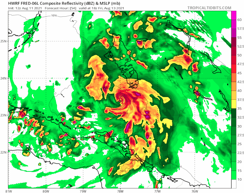
Pretty good east shift and a substantial uptick in intensity on the 12z HWRF versus the 06z.
0 likes
Fourth Generation Florida Native
Personal Storm History: David 79, Andrew 92, Erin 95, Floyd 99, Irene 99, Frances 04, Jeanne 04, Wilma 05, Matthew 16, Irma 17, Ian 22, Nicole 22, Milton 24
Personal Storm History: David 79, Andrew 92, Erin 95, Floyd 99, Irene 99, Frances 04, Jeanne 04, Wilma 05, Matthew 16, Irma 17, Ian 22, Nicole 22, Milton 24
-
Blown Away

- S2K Supporter
- Posts: 10253
- Joined: Wed May 26, 2004 6:17 am
Re: ATL: FRED - Models
SFLcane wrote:Slow down hwrf..
https://i.postimg.cc/KjxhJtnG/4-BFA59-A8-FF30-4242-B1-A5-D291-CC75-C7-EE.gif
@2.5 degrees E of 06z at @54 hrs.
0 likes
Hurricane Eye Experience: David 79, Irene 99, Frances 04, Jeanne 04, Wilma 05… Hurricane Brush Experience: Andrew 92, Erin 95, Floyd 99, Matthew 16, Irma 17, Ian 22, Nicole 22…
-
tolakram
- Admin
- Posts: 20186
- Age: 62
- Joined: Sun Aug 27, 2006 8:23 pm
- Location: Florence, KY (name is Mark)
Re: ATL: FRED - Models
OuterBanker wrote:I guess I can't post directly from Weathernerds.
Links:https://www.weathernerds.org/models/gefs.html
https://www.weathernerds.org/models/ecens.html
No, you cannot embed images here, you have to copy them to an image hosting service. In the case of weathernerds it's not us blocking, it's them, to conserve bandwidth. This is why we implemented our policy years ago. When you embed an image from another weather site their bandwidth is used to supply the image to every user that views it on storm2k. We get the traffic, they pay for the bandwidth. That's not a good thing.
1 likes
M a r k
- - - - -
Join us in chat: Storm2K Chatroom Invite. Android and IOS apps also available.
The posts in this forum are NOT official forecasts and should not be used as such. Posts are NOT endorsed by any professional institution or STORM2K.org. For official information and forecasts, please refer to NHC and NWS products.
- - - - -
Join us in chat: Storm2K Chatroom Invite. Android and IOS apps also available.
The posts in this forum are NOT official forecasts and should not be used as such. Posts are NOT endorsed by any professional institution or STORM2K.org. For official information and forecasts, please refer to NHC and NWS products.
-
AtlanticWind

- S2K Supporter
- Posts: 1898
- Age: 67
- Joined: Sun Aug 08, 2004 9:57 pm
- Location: Plantation,Fla

Re: ATL: FRED - Models
The HWRF is back to being the HWRF on this run. After having the center 'jump' north over Hispaniola it shows Fred pulling itself together on late Friday becoming a hurricane, also a bit slower than most of the models.

Last edited by Jr0d on Wed Aug 11, 2021 12:26 pm, edited 1 time in total.
0 likes
Who is online
Users browsing this forum: No registered users and 18 guests