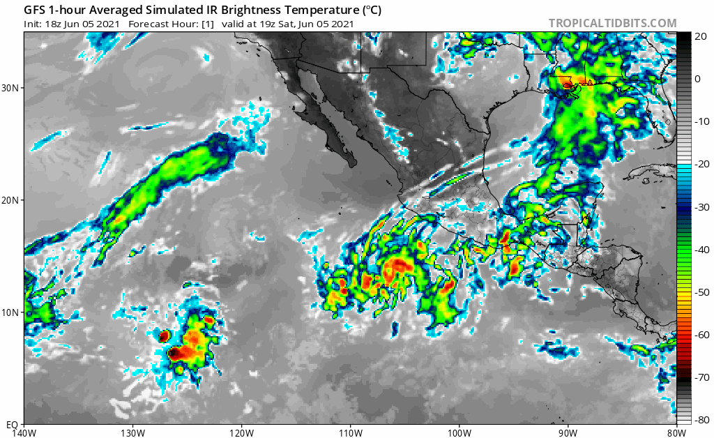
EPAC: CARLOS - Remnants

Moderator: S2k Moderators

Message
Author
User avatar
Kingarabian
S2K Supporter
S2K Supporter
Posts: 15461
Joined: Sat Aug 08, 2009 3:06 am
Location: Honolulu, Hawaii

Re: EPAC: INVEST 92E

#41 Postby Kingarabian » Sat Jun 05, 2021 6:01 pm

Yellow Evan wrote:
Kingarabian wrote:18z GFS no longer develops it LOL


https://i.imgur.com/IsuSI8J.png

Terrible initialization.


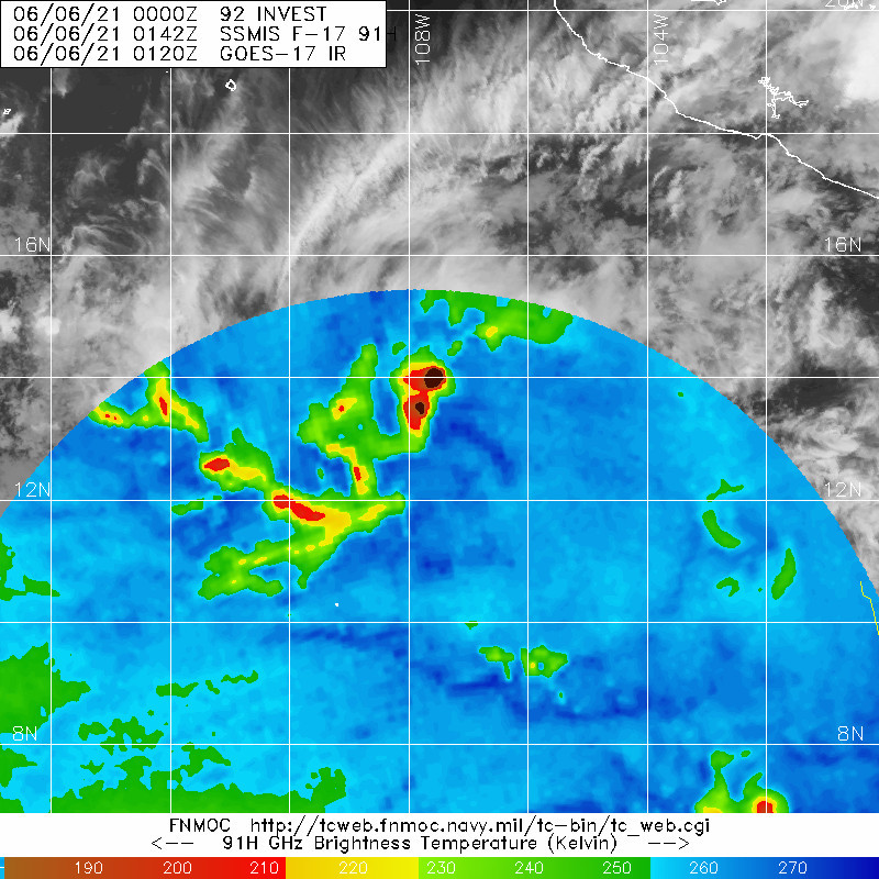
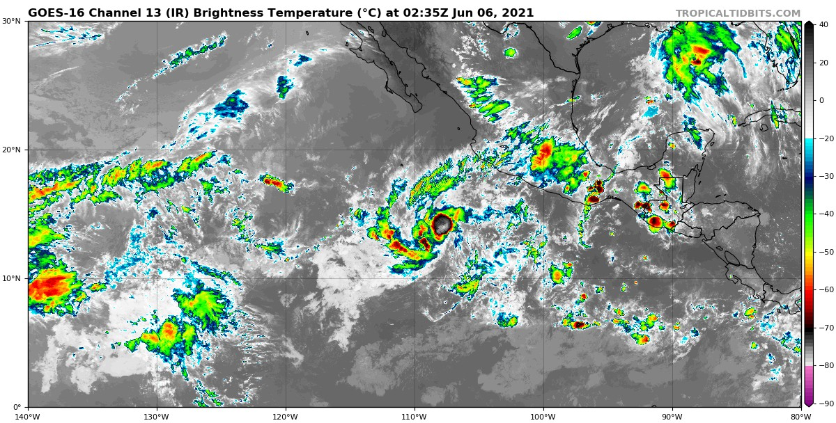
Yeah probably bad initialization. NHC had this @ 1006mb. HMON and HWRF runs will be interesting. Also this appears to be a larger system than what the models are showing.

Edit: 18z HMON still makes this a hurricane. 18z HWRF much weaker peaks it as a TS in 24 hours.
0 likes   
RIP Kobe Bryant

User avatar
cycloneye
Admin
Admin
Posts: 139593
Age: 67
Joined: Thu Oct 10, 2002 10:54 am
Location: San Juan, Puerto Rico

Re: EPAC: INVEST 92E

#42 Postby cycloneye » Sat Jun 05, 2021 6:15 pm

Showers and thunderstorms are showing signs of organization in
association with an area of low pressure located about 500 miles
south-southwest of Manzanillo, Mexico. However, recent satellite
wind data indicate that the circulation remains broad and not well
defined. A tropical depression is likely to form during the next
day or so while the system moves slowly westward. Environmental
conditions are expected to become less conducive for development in
a few days.

* Formation chance through 48 hours...high...80 percent.
* Formation chance through 5 days...high...80 percent.
1 likes   
Visit the Caribbean-Central America Weather Thread where you can find at first post web cams,radars
and observations from Caribbean basin members Click Here

User avatar
Yellow Evan
Professional-Met
Professional-Met
Posts: 15960
Age: 25
Joined: Fri Jul 15, 2011 12:48 pm
Location: Henderson, Nevada/Honolulu, HI
Contact:

Re: EPAC: INVEST 92E

#43 Postby Yellow Evan » Sat Jun 05, 2021 6:16 pm

4 likes   

User avatar
Kingarabian
S2K Supporter
S2K Supporter
Posts: 15461
Joined: Sat Aug 08, 2009 3:06 am
Location: Honolulu, Hawaii

Re: EPAC: INVEST 92E

#44 Postby Kingarabian » Sat Jun 05, 2021 6:31 pm


The 18z GFS and HWRF initialized it @ 12.9N/108W - which would be closer to the MLC - per Papin's GIF
The 18z HMON initialized it @ 13.4N/107W - which would be the broad LLC - per the ASCAT-C pass Papin posted in the follow up tweet.

Wonder if this is playing a role.
1 likes   
RIP Kobe Bryant

User avatar
Kingarabian
S2K Supporter
S2K Supporter
Posts: 15461
Joined: Sat Aug 08, 2009 3:06 am
Location: Honolulu, Hawaii

Re: EPAC: INVEST 92E

#45 Postby Kingarabian » Sat Jun 05, 2021 7:06 pm

SAB up to 1.5:
TXPZ21 KNES 052351
TCSENP

A. TROPICAL DISTURBANCE (92E)

B. 05/2330Z

C. 12.7N

D. 109.1W

E. THREE/GOES-W

F. T1.5/1.5

G. IR/EIR/VIS

H. REMARKS...3/10 BANDING AROUND LLCC YIELDS DT OF 1.5. MET AND PT
AGREE AND FT IS BASED ON DT.

I. ADDL POSITIONS

NIL


...MLEVINE


Why is the fix that far west of the ASCAT-C depicted LLC.

18z Euro also significantly weaker.
Last edited by Kingarabian on Sat Jun 05, 2021 7:13 pm, edited 1 time in total.
0 likes   
RIP Kobe Bryant

User avatar
aspen
Category 5
Category 5
Posts: 8061
Joined: Sat Oct 12, 2019 7:10 pm
Location: Connecticut, USA

Re: EPAC: INVEST 92E

#46 Postby aspen » Sat Jun 05, 2021 7:09 pm

I wonder if this is going to be a theme with the EPac this year: models showing at least a decently strong storm only for them to back off in the very short term. Model runs for Blanca were more aggressive before 1-2 days out, and it only peaked as a 50 kt TS.
0 likes   
Irene '11 Sandy '12 Hermine '16 5/15/2018 Derecho Fay '20 Isaias '20 Elsa '21 Henri '21 Ida '21

I am only a meteorology enthusiast who knows a decent amount about tropical cyclones. Look to the professional mets, the NHC, or your local weather office for the best information.

User avatar
Kingarabian
S2K Supporter
S2K Supporter
Posts: 15461
Joined: Sat Aug 08, 2009 3:06 am
Location: Honolulu, Hawaii

Re: EPAC: INVEST 92E

#47 Postby Kingarabian » Sat Jun 05, 2021 7:17 pm

aspen wrote:I wonder if this is going to be a theme with the EPac this year: models showing at least a decently strong storm only for them to back off in the very short term. Model runs for Blanca were more aggressive before 1-2 days out, and it only peaked as a 50 kt TS.


The theme so far has been the models in general being aggressive in the medium and long range, then when the disturbance actually consolidates and begins to develop they drop it.
4 likes   
RIP Kobe Bryant

User avatar
Kingarabian
S2K Supporter
S2K Supporter
Posts: 15461
Joined: Sat Aug 08, 2009 3:06 am
Location: Honolulu, Hawaii

Re: EPAC: INVEST 92E

#48 Postby Kingarabian » Sat Jun 05, 2021 7:30 pm

Kingarabian wrote:SAB up to 1.5:
TXPZ21 KNES 052351
TCSENP

A. TROPICAL DISTURBANCE (92E)

B. 05/2330Z

C. 12.7N

D. 109.1W

E. THREE/GOES-W

F. T1.5/1.5

G. IR/EIR/VIS

H. REMARKS...3/10 BANDING AROUND LLCC YIELDS DT OF 1.5. MET AND PT
AGREE AND FT IS BASED ON DT.

I. ADDL POSITIONS

NIL


...MLEVINE


Why is the fix that far west of the ASCAT-C depicted LLC.


I'm not sure if this fix even lines up with this SSMIS MW pass:
Image
0 likes   
RIP Kobe Bryant

User avatar
Kingarabian
S2K Supporter
S2K Supporter
Posts: 15461
Joined: Sat Aug 08, 2009 3:06 am
Location: Honolulu, Hawaii

Re: EPAC: INVEST 92E

#49 Postby Kingarabian » Sat Jun 05, 2021 7:39 pm

Steady hot towers going off WNW/NW the actual center with the sun going down:
Image
0 likes   
RIP Kobe Bryant

User avatar
Yellow Evan
Professional-Met
Professional-Met
Posts: 15960
Age: 25
Joined: Fri Jul 15, 2011 12:48 pm
Location: Henderson, Nevada/Honolulu, HI
Contact:

Re: EPAC: INVEST 92E

#50 Postby Yellow Evan » Sat Jun 05, 2021 7:41 pm

* GFS version *
* EAST PACIFIC 2021 SHIPS INTENSITY FORECAST *
* IR SAT DATA AVAILABLE, OHC AVAILABLE *
* INVEST EP922021 06/06/21 00 UTC *

TIME (HR) 0 6 12 18 24 36 48 60 72 84 96 108 120 132 144 156 168
V (KT) NO LAND 25 25 24 24 25 28 34 37 39 39 40 42 45 49 51 52 52
V (KT) LAND 25 25 24 24 25 28 34 37 39 39 40 42 45 49 51 52 52
V (KT) LGEM 25 25 25 25 25 25 24 24 24 23 23 23 23 24 24 25 24
Storm Type TROP TROP TROP TROP TROP TROP TROP TROP TROP TROP TROP TROP TROP TROP TROP TROP TROP

SHEAR (KT) 8 6 9 11 12 13 14 18 20 16 15 12 8 4 4 3 9
SHEAR ADJ (KT) -6 -2 0 0 0 0 -2 -2 -3 -3 -3 -1 -1 2 2 4 5
SHEAR DIR 142 128 134 130 121 108 101 105 102 106 102 84 72 88 125 217 261
SST (C) 29.6 29.6 29.7 29.7 29.7 29.3 29.1 29.1 28.7 28.5 28.5 28.4 27.4 27.4 27.6 27.4 27.2
POT. INT. (KT) 158 159 159 158 159 156 154 155 151 149 149 148 137 135 139 139 138
200 MB T (C) -53.0 -53.4 -53.6 -53.5 -53.3 -53.8 -53.8 -53.7 -53.5 -53.9 -53.9 -54.2 -54.1 -54.4 -54.0 -54.2 -54.2
200 MB VXT (C) -0.2 -0.2 -0.2 -0.2 -0.1 0.1 0.2 0.1 0.0 0.1 0.0 0.0 0.0 0.0 0.0 0.0 0.0
TH_E DEV (C) 5 5 5 5 5 5 5 5 5 4 4 3 3 3 3 3 2
700-500 MB RH 67 64 63 61 62 62 59 59 59 61 62 60 58 57 52 48 43
MODEL VTX (KT) 7 7 7 8 8 7 6 5 4 3 4 3 LOST LOST LOST LOST LOST
850 MB ENV VOR -23 -12 -11 -9 -6 4 8 6 6 0 -4 -8 -8 -7 -7 -15 -19
200 MB DIV 43 37 6 0 0 0 22 -13 -21 -21 1 -1 8 19 20 0 -14
700-850 TADV 0 0 0 0 1 3 2 3 -1 -1 0 2 0 3 2 6 3
LAND (KM) 737 777 813 829 845 938 1032 1127 1298 1403 1487 1597 1744 1826 1864 1977 2199
LAT (DEG N) 13.0 xx.x xx.x xx.x xx.x xx.x xx.x xx.x xx.x xx.x xx.x xx.x xx.x xx.x xx.x xx.x xx.x
LONG(DEG W) 107.5 xxx.x xxx.x xxx.x xxx.x xxx.x xxx.x xxx.x xxx.x xxx.x xxx.x xxx.x xxx.x xxx.x xxx.x xxx.x xxx.x
STM SPEED (KT) 3 5 3 2 4 5 5 7 9 8 8 10 8 4 6 12 16
HEAT CONTENT 34 44 57 60 61 47 26 17 17 24 12 12 8 14 18 10 9

FORECAST TRACK FROM OFPI INITIAL HEADING/SPEED (DEG/KT): 20/ 1 CX,CY: 0/ 1
T-12 MAX WIND: 25 PRESSURE OF STEERING LEVEL (MB): 553 (MEAN=587)
GOES IR BRIGHTNESS TEMP. STD DEV. 50-200 KM RAD: 27.1 (MEAN=14.5)
% GOES IR PIXELS WITH T < -20 C 50-200 KM RAD: 45.0 (MEAN=65.0)
PRELIM RI PROB (DV .GE. 35 KT IN 36 HR): 3.2

INDIVIDUAL CONTRIBUTIONS TO INTENSITY CHANGE
6 12 18 24 36 48 60 72 84 96 108 120 132 144 156 168
------------------------------------------------------------------------------
SAMPLE MEAN CHANGE 0. 0. 1. 1. 1. 2. 1. 1. 0. -0. -1. -2. -2. -3. -4. -4.
SST POTENTIAL -0. -1. -1. 0. 5. 12. 19. 26. 30. 33. 35. 37. 39. 40. 41. 43.
VERTICAL SHEAR MAG 1. 2. 2. 3. 4. 3. 1. -1. -2. -3. -3. -2. 0. 2. 3. 3.
VERTICAL SHEAR ADJ 0. 1. 1. 1. 1. 1. 1. 1. 1. 0. 0. 0. 0. 0. 0. 0.
VERTICAL SHEAR DIR 0. 0. 0. 1. 2. 4. 5. 6. 7. 7. 8. 8. 8. 7. 5. 3.
PERSISTENCE -0. -0. -0. -1. -1. -1. -0. -0. -0. -0. -0. -0. -0. -0. -0. -0.
200/250 MB TEMP. 0. 0. -0. -0. -0. -1. -1. -2. -2. -2. -2. -2. -2. -3. -3. -3.
THETA_E EXCESS -0. -0. -0. -1. -1. -2. -2. -2. -3. -3. -4. -4. -5. -5. -7. -8.
700-500 MB RH 0. 0. 0. 0. 0. 0. -0. -0. -0. -0. -0. -0. -0. -0. -0. -1.
MODEL VTX TENDENCY 0. 0. 1. 1. -0. -1. -3. -4. -5. -5. -5. -5. -4. -4. -4. -3.
850 MB ENV VORTICITY -0. -0. -0. -0. -0. 0. 0. 0. 1. 1. 1. 1. 1. 1. 1. 1.
200 MB DIVERGENCE 0. -0. -0. -0. -1. -1. -2. -3. -4. -4. -4. -3. -2. -1. 0. 1.
850-700 T ADVEC -0. -0. -0. -0. -0. 0. 0. 0. 0. 0. 0. 0. 0. 0. 1. 1.
ZONAL STORM MOTION -0. -0. -1. -1. -2. -3. -4. -3. -3. -3. -3. -3. -2. -2. -1. 0.
STEERING LEVEL PRES -0. -0. -0. -0. -0. -0. -0. -0. -0. -0. -0. -1. -0. -0. -0. -0.
DAYS FROM CLIM. PEAK -0. -0. -0. -0. -0. -0. -1. -1. -2. -2. -2. -2. -3. -3. -4. -5.
GOES PREDICTORS -1. -1. -1. -1. -2. -3. -3. -4. -4. -5. -6. -6. -6. -6. -5. -4.
OCEAN HEAT CONTENT 0. 0. 0. 0. 1. 2. 2. 1. 1. 0. -0. -1. -1. -1. -2. -3.
RI POTENTIAL -0. -1. -1. -2. -3. -3. -2. -1. 1. 2. 3. 4. 4. 4. 4. 4.
------------------------------------------------------------------------------
TOTAL CHANGE -0. -1. -0. -0. 3. 9. 12. 14. 14. 15. 17. 20. 24. 26. 27. 27.

CURRENT MAX WIND (KT): 25. LAT, LON: 13.0 107.5

** 2021 E. Pacific RI INDEX EP922021 INVEST 06/06/21 00 UTC **
(SHIPS-RII PREDICTOR TABLE for 30 KT OR MORE MAXIMUM WIND INCREASE IN NEXT 24-h)

Predictor Value RI Predictor Range Scaled Value(0-1) % Contribution
POT = MPI-VMAX (KT) : 133.5 40.5 to 149.3 0.85 6.0
12 HR PERSISTENCE (KT) : 0.0 -22.0 to 44.0 0.33 2.7
D200 (10**7s-1) : 17.2 -33.0 to 159.5 0.26 1.7
850-200 MB SHEAR (KT) : 9.3 19.6 to 1.3 0.56 3.5
MAXIMUM WIND (KT) : 25.0 22.5 to 132.0 0.07 0.3
STD DEV OF IR BR TEMP : 27.1 37.8 to 2.1 0.30 1.3
BL DRY-AIR FLUX (W/M2) : 79.8 800.8 to -82.5 0.82 -4.0
HEAT CONTENT (KJ/CM2) : 51.2 2.7 to 106.7 0.47 1.7
%area of TPW <45 mm upshear : 0.0 56.6 to 0.0 1.00 1.4
2nd PC OF IR BR TEMP : -1.7 2.2 to -2.3 0.87 0.7

SHIPS Prob RI for 20kt/ 12hr RI threshold= 0% is 0.0 times climatological mean ( 6.3%)
SHIPS Prob RI for 25kt/ 24hr RI threshold= 16% is 1.3 times climatological mean (12.5%)
SHIPS Prob RI for 30kt/ 24hr RI threshold= 15% is 1.8 times climatological mean ( 8.6%)
SHIPS Prob RI for 35kt/ 24hr RI threshold= 0% is 0.0 times climatological mean ( 6.2%)
SHIPS Prob RI for 40kt/ 24hr RI threshold= 0% is 0.0 times climatological mean ( 4.2%)
SHIPS Prob RI for 45kt/ 36hr RI threshold= 14% is 2.1 times climatological mean ( 6.7%)
SHIPS Prob RI for 55kt/ 48hr RI threshold= 13% is 2.2 times climatological mean ( 5.9%)
SHIPS Prob RI for 65kt/ 72hr RI threshold= 0% is 0.0 times climatological mean ( 4.7%)

Matrix of RI probabilities
------------------------------------------------------------------------------
RI (kt / h) | 20/12 | 25/24 | 30/24 | 35/24 | 40/24 | 45/36 | 55/48 |65/72
------------------------------------------------------------------------------
SHIPS-RII: 0.0% 16.1% 15.4% 0.0% 0.0% 14.3% 13.3% 0.0%
Logistic: 0.8% 4.1% 1.7% 0.6% 0.2% 0.8% 0.9% 6.6%
Bayesian: 0.1% 0.7% 0.0% 0.0% 0.0% 0.0% 0.0% 0.0%
Consensus: 0.3% 6.9% 5.7% 0.2% 0.1% 5.1% 4.7% 2.2%
DTOPS: 0.0% 0.0% 0.0% 0.0% 0.0% 0.0% 0.0% 0.0%

## ANNULAR HURRICANE INDEX (AHI) EP922021 INVEST 06/06/21 00 UTC ##
## STORM NOT ANNULAR, SCREENING STEP FAILED, NPASS=4 NFAIL=3 ##
## AHI= 0 (AHI OF 100 IS BEST FIT TO ANN. STRUC., 1 IS MARGINAL, 0 IS NOT ANNULAR) ##
0 likes   

JW-_-
Category 1
Category 1
Posts: 281
Joined: Thu Mar 04, 2021 4:46 pm

Re: EPAC: INVEST 92E

#51 Postby JW-_- » Sat Jun 05, 2021 7:48 pm

Image
0 likes   

JW-_-
Category 1
Category 1
Posts: 281
Joined: Thu Mar 04, 2021 4:46 pm

Re: EPAC: INVEST 92E

#52 Postby JW-_- » Sat Jun 05, 2021 8:18 pm

Gotta luv global weather you guys will be tracking tropical vort's over the next week. In my neck of the woods, it will be tracking potential snow storms. :D
1 likes   

User avatar
Yellow Evan
Professional-Met
Professional-Met
Posts: 15960
Age: 25
Joined: Fri Jul 15, 2011 12:48 pm
Location: Henderson, Nevada/Honolulu, HI
Contact:

Re: EPAC: INVEST 92E

#53 Postby Yellow Evan » Sat Jun 05, 2021 8:33 pm

Image

Better but needs to sustain itself though it’s clearly becoming more stacked.
4 likes   

User avatar
Kingarabian
S2K Supporter
S2K Supporter
Posts: 15461
Joined: Sat Aug 08, 2009 3:06 am
Location: Honolulu, Hawaii

Re: EPAC: INVEST 92E

#54 Postby Kingarabian » Sat Jun 05, 2021 8:48 pm

:uarrow: That big burst of convection is almost entirely over the LLC
4 likes   
RIP Kobe Bryant

storminabox
Category 1
Category 1
Posts: 261
Joined: Sun Jul 09, 2017 10:50 pm

Re: EPAC: INVEST 92E

#55 Postby storminabox » Sat Jun 05, 2021 9:00 pm

Kingarabian wrote:
aspen wrote:I wonder if this is going to be a theme with the EPac this year: models showing at least a decently strong storm only for them to back off in the very short term. Model runs for Blanca were more aggressive before 1-2 days out, and it only peaked as a 50 kt TS.


The theme so far has been the models in general being aggressive in the medium and long range, then when the disturbance actually consolidates and begins to develop they drop it.


This has been the theme in the EPAC for the several years it seems like.
5 likes   

User avatar
Kingarabian
S2K Supporter
S2K Supporter
Posts: 15461
Joined: Sat Aug 08, 2009 3:06 am
Location: Honolulu, Hawaii

Re: EPAC: INVEST 92E

#56 Postby Kingarabian » Sat Jun 05, 2021 9:29 pm

Image
0 likes   
RIP Kobe Bryant

User avatar
Yellow Evan
Professional-Met
Professional-Met
Posts: 15960
Age: 25
Joined: Fri Jul 15, 2011 12:48 pm
Location: Henderson, Nevada/Honolulu, HI
Contact:

Re: EPAC: INVEST 92E

#57 Postby Yellow Evan » Sat Jun 05, 2021 9:37 pm

storminabox wrote:
Kingarabian wrote:
aspen wrote:I wonder if this is going to be a theme with the EPac this year: models showing at least a decently strong storm only for them to back off in the very short term. Model runs for Blanca were more aggressive before 1-2 days out, and it only peaked as a 50 kt TS.


The theme so far has been the models in general being aggressive in the medium and long range, then when the disturbance actually consolidates and begins to develop they drop it.


This has been the theme in the EPAC for the several years it seems like.


It's been an issue since at least 2018.
1 likes   

User avatar
Kingarabian
S2K Supporter
S2K Supporter
Posts: 15461
Joined: Sat Aug 08, 2009 3:06 am
Location: Honolulu, Hawaii

Re: EPAC: INVEST 92E

#58 Postby Kingarabian » Sat Jun 05, 2021 9:55 pm

I think 92E is exceeding the models forecasts. Here is the forecast IR satellite simulation from the 18zGFS. Keeps it disorganized and doesn't show it looking its best until another 24 hours from now then quickly weakens it:
Image

Currently:
Image
1 likes   
RIP Kobe Bryant

User avatar
Yellow Evan
Professional-Met
Professional-Met
Posts: 15960
Age: 25
Joined: Fri Jul 15, 2011 12:48 pm
Location: Henderson, Nevada/Honolulu, HI
Contact:

Re: EPAC: INVEST 92E

#59 Postby Yellow Evan » Sat Jun 05, 2021 11:35 pm

0z GFS still doesn't have it.

And its satellite appearance last couple hours seems to have treaded water.
0 likes   

User avatar
Kingarabian
S2K Supporter
S2K Supporter
Posts: 15461
Joined: Sat Aug 08, 2009 3:06 am
Location: Honolulu, Hawaii

Re: EPAC: INVEST 92E

#60 Postby Kingarabian » Sat Jun 05, 2021 11:47 pm

Yellow Evan wrote:0z GFS still doesn't have it.

And its satellite appearance last couple hours seems to have treaded water.

00z GFS briefly brings it down to 1003mb. IMO it has a much deeper 850mb and 500mb vort signature than what the models are initializing.
0 likes   
RIP Kobe Bryant


Return to “2021”

Who is online

Users browsing this forum: No registered users and 8 guests