ATL: FRED - Models
Moderator: S2k Moderators
-
Blown Away

- S2K Supporter

- Posts: 10253
- Joined: Wed May 26, 2004 6:17 am
Re: ATL: SIX - Models
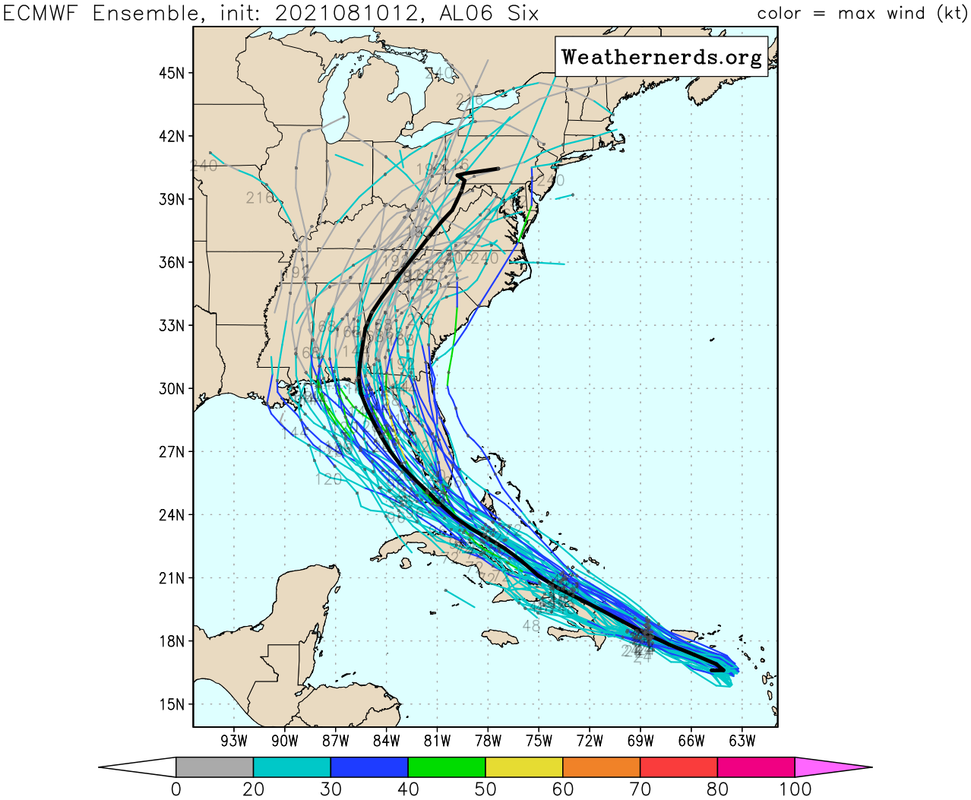
I do feel a little better, the Euro is back on the L and GFS on the R of the model spaghetti plot. 
2 likes
Hurricane Eye Experience: David 79, Irene 99, Frances 04, Jeanne 04, Wilma 05… Hurricane Brush Experience: Andrew 92, Erin 95, Floyd 99, Matthew 16, Irma 17, Ian 22, Nicole 22…

Re: ATL: SIX - Models
The EURO shows high pressure extending slightly further west, hence it makes the north turn further west. Keeps it weak though.
EURO @12Z Friday:

EURO @12Z Friday:
0 likes


-
tolakram
- Admin

- Posts: 20186
- Age: 62
- Joined: Sun Aug 27, 2006 8:23 pm
- Location: Florence, KY (name is Mark)
Re: ATL: SIX - Models
Very similar, but weaker, than the last run. Euro is great on track, usually, and bad on intensity, usually.
3 likes
M a r k
- - - - -
Join us in chat: Storm2K Chatroom Invite. Android and IOS apps also available.
The posts in this forum are NOT official forecasts and should not be used as such. Posts are NOT endorsed by any professional institution or STORM2K.org. For official information and forecasts, please refer to NHC and NWS products.
-
Blown Away
- S2K Supporter
- Posts: 10253
- Joined: Wed May 26, 2004 6:17 am
Re: ATL: SIX - Models
tolakram wrote:Very similar, but weaker, than the last run. Euro is great on track, usually, and bad on intensity, usually.
Except with Elsa... But still the King IMO...
0 likes
Hurricane Eye Experience: David 79, Irene 99, Frances 04, Jeanne 04, Wilma 05… Hurricane Brush Experience: Andrew 92, Erin 95, Floyd 99, Matthew 16, Irma 17, Ian 22, Nicole 22…

-
Hypercane_Kyle

- Category 5

- Posts: 3465
- Joined: Sat Mar 07, 2015 7:58 pm
- Location: Cape Canaveral, FL
Re: ATL: SIX - Models
Blown Away wrote:tolakram wrote:Very similar, but weaker, than the last run. Euro is great on track, usually, and bad on intensity, usually.
Except with Elsa... But still the King IMO...
I cannot off-hand think of a model that did worse with TC genesis last year than the "king" did.
Also missed Elsa's genesis, go figure.
2 likes
My posts are my own personal opinion, defer to the National Hurricane Center (NHC) and other NOAA products for decision making during hurricane season.
-
Stormybajan

- Category 1

- Posts: 453
- Joined: Thu May 20, 2021 3:21 pm
- Location: Windward Islands
Re: ATL: SIX - Models
Blown Away wrote:tolakram wrote:Very similar, but weaker, than the last run. Euro is great on track, usually, and bad on intensity, usually.
Except with Elsa... But still the King IMO...
The King got banished last year after being the worst model for genesis ever!
3 likes
Sad West Indies and Manchester United fan ⚽️
-
toad strangler

- S2K Supporter
- Posts: 4546
- Joined: Sun Jul 28, 2013 3:09 pm
- Location: Earth
- Contact:
Re: ATL: SIX - Models
SFLcane wrote:18z shifts east.
https://i.postimg.cc/FFfbkBn9/8-FE7-EBC4-AC81-4257-8598-6357-E40-F7881.gif
I don't think I see the UKMET in there
0 likes
My Weather Station
https://www.wunderground.com/dashboard/pws/KFLPORTS603
https://www.wunderground.com/dashboard/pws/KFLPORTS603
-
Evil Jeremy

- S2K Supporter
- Posts: 5463
- Age: 32
- Joined: Mon Apr 10, 2006 2:10 pm
- Location: Los Angeles, CA
Re: ATL: SIX - Models
toad strangler wrote:SFLcane wrote:18z shifts east.
https://i.postimg.cc/FFfbkBn9/8-FE7-EBC4-AC81-4257-8598-6357-E40-F7881.gif
I don't think I see the UKMET in there
If I’m reading the 12z UKMET text file correctly, it drops Six entirely after 48 hours
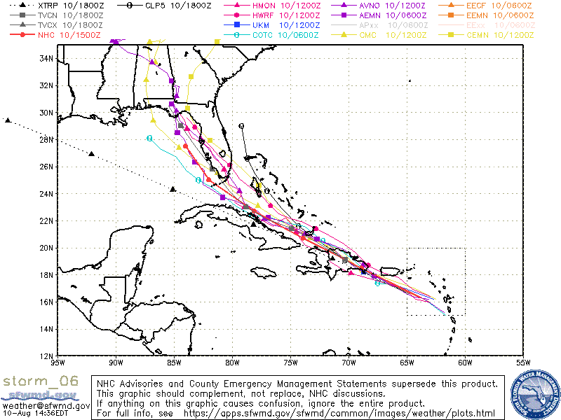
EDIT: indeed, you can see a single dark blue square representing the 24 hour point of the 12z UKMET on the SFWMD plot, if you look closely around the eastern dip of the Dominican Republic, you will see it.
3 likes
Frances 04 / Jeanne 04 / Katrina 05 / Wilma 05 / Fay 08 / Debby 12 / Andrea 13 / Colin 16 / Hermine 16 / Matthew 16 / Irma 17
Re: ATL: SIX - Models
Shell Mound wrote:Hypercane_Kyle wrote:I will say the potential for a quick episode of rapid intensification right before FL is a little concerning. Conditions do appear more favorable than they were a few days ago.
TheIf PTC Six were somehow to “do the impossible” and end up striking Southeast Florida as a deepening hurricane, it would be similar to a storm like Cleo (1964) or Andrew (1992): a storm that will not be memorable outside a very small area that happens to experience the strongest winds. By contrast, a large major hurricane like Wilma or the 1926 Miami hurricane would deliver a greater variety of hazards besides wind to a much larger area. During Andrew people just 30 n mi north of the eye were barely cognisant of a major storm.
The urban density of SFL is such that millions will be in the "memorable" part of the "small area". A bit of an ignorant view of the peninsula if I may say.
4 likes
Andrew (1992), Irene (1999), Frances (2004), Katrina (2005), Wilma (2005), Fay (2008), Irma (2017), Eta (2020), Ian (2022)
-
got ants?

- Tropical Storm

- Posts: 117
- Age: 67
- Joined: Sat Sep 03, 2011 3:44 am
- Location: Hollywood/Ft Laud
Re: ATL: SIX - Models
Shell Mound wrote:During Andrew people just 30 n mi north of the eye were barely cognisant of a major storm.
Huh? I live in Hollywood, a d we were supposed to be where Andrew landed. A d we had sustained wi ds of 120 MPH. Trees, telephone poles, and traffic lights in the street. We were well aware if what was happening, and I'm probably 60 miles from where the eye struck.
4 likes
This post is NOT AN OFFICIAL FORECAST and should not be used as such. It is just the opinion of the poster and may or may not be backed by sound meteorological data. It is NOT endorsed by any professional institution including storm2k.org. For Official Information please refer to the NHC and NWS products.

Re: ATL: SIX - Models
Jr0d wrote:Once again forward speed now makes a big difference on when the turn north will happen. The general trend is a slower storm will turn north further east. The EURO, JMA and to a lesser extent the CMC show the high extending just a little further east and push the storm into the Florida Keys before turning north.
Even 1 mph forward speed difference could mean the difference of turning north into south Florida and limiting time over the water in very favorable conditions or remaining in open water over the Florida Keys while strengthening (perhaps rapidly).
Even a 50 mile difference on the track can make a huge difference.
First thing is Hispaniola, if this system passes just north of the island like the HWRF is showing, then I think the Florida Keys and S. Florida could see a hurricane.
The one thing that is certain is it will be a very small storm until it makes the turn north. This is good for limiting the impacted area but bad because how fast tiny storms can intensify.
Very intelligent post, including the observation regarding the small core circulation. This will largely play into what remains following either slipping through the Mona Passage, a slight brief brush with land, or an all out high-terrain burial (queue music now for "The Hills Are Alive" - Julie Andrews/Sound of Music Soundtrack). Anything else regarding track or intensity beyond that hurdle is really very speculative.
3 likes
Andy D
(For official information, please refer to the NHC and NWS products.)
(For official information, please refer to the NHC and NWS products.)
Re: ATL: SIX - Models
Nuno wrote:The urban density of SFL is such that millions will be in the "memorable" part of the "small area". A bit of an ignorant view of the peninsula if I may say.
Also the population of the Homestead area has exploded since 1992. Had Andrew hit today, it would be much worse for the area.
All of SFL within 20 miles of the coast is densely populated so a small storm will still affect a lot of people. That area has not a a major hurricane since Andrew. Eventually South Florida will see one again and it will be ugly. In my opinion the majority of the population in that area has become complacent to the hurricane threat.
I doubt soon to be Fred will be a major storm, however a rapidly strengthening hurricane making landfall in the densely populated Miami area is becoming a possibility with this one.
8 likes
-
tolakram
- Admin
- Posts: 20186
- Age: 62
- Joined: Sun Aug 27, 2006 8:23 pm
- Location: Florence, KY (name is Mark)
Re: ATL: SIX - Models
Let's get back on topic please.
1 likes
M a r k
- - - - -
Join us in chat: Storm2K Chatroom Invite. Android and IOS apps also available.
The posts in this forum are NOT official forecasts and should not be used as such. Posts are NOT endorsed by any professional institution or STORM2K.org. For official information and forecasts, please refer to NHC and NWS products.
- - - - -
Join us in chat: Storm2K Chatroom Invite. Android and IOS apps also available.
The posts in this forum are NOT official forecasts and should not be used as such. Posts are NOT endorsed by any professional institution or STORM2K.org. For official information and forecasts, please refer to NHC and NWS products.
-
gatorcane

- S2K Supporter
- Posts: 23708
- Age: 48
- Joined: Sun Mar 13, 2005 3:54 pm
- Location: Boca Raton, FL
Re: ATL: SIX - Models
Active Euro ensembles but most are weak.
Last edited by gatorcane on Tue Aug 10, 2021 2:54 pm, edited 1 time in total.
1 likes
-
Spacecoast

- Category 2

- Posts: 773
- Joined: Thu Aug 31, 2017 2:03 pm
Re: ATL: SIX - Models
Kitchen sink Spaghetti:
Euro ensembles + GFS ensembles + Operational+official
(White is consensus):

Euro ensembles + GFS ensembles + Operational+official
(White is consensus):
0 likes
Re: ATL: SIX - Models
18z icon shifts a bit left, moves up through Florida instead of riding the east coast, but shifts into the Gulf around Ft. Myers.
0 likes
-
tolakram
- Admin
- Posts: 20186
- Age: 62
- Joined: Sun Aug 27, 2006 8:23 pm
- Location: Florence, KY (name is Mark)
Re: ATL: SIX - Models
18Z GFS a bit south

0 likes
M a r k
- - - - -
Join us in chat: Storm2K Chatroom Invite. Android and IOS apps also available.
The posts in this forum are NOT official forecasts and should not be used as such. Posts are NOT endorsed by any professional institution or STORM2K.org. For official information and forecasts, please refer to NHC and NWS products.
- - - - -
Join us in chat: Storm2K Chatroom Invite. Android and IOS apps also available.
The posts in this forum are NOT official forecasts and should not be used as such. Posts are NOT endorsed by any professional institution or STORM2K.org. For official information and forecasts, please refer to NHC and NWS products.
-
tolakram
- Admin
- Posts: 20186
- Age: 62
- Joined: Sun Aug 27, 2006 8:23 pm
- Location: Florence, KY (name is Mark)
Re: ATL: SIX - Models
And now nearly identical.

0 likes
M a r k
- - - - -
Join us in chat: Storm2K Chatroom Invite. Android and IOS apps also available.
The posts in this forum are NOT official forecasts and should not be used as such. Posts are NOT endorsed by any professional institution or STORM2K.org. For official information and forecasts, please refer to NHC and NWS products.
- - - - -
Join us in chat: Storm2K Chatroom Invite. Android and IOS apps also available.
The posts in this forum are NOT official forecasts and should not be used as such. Posts are NOT endorsed by any professional institution or STORM2K.org. For official information and forecasts, please refer to NHC and NWS products.
Who is online
Users browsing this forum: No registered users and 20 guests