ATL: FRED - Models
Moderator: S2k Moderators
-
Shell Mound
- Category 5

- Posts: 2432
- Age: 33
- Joined: Thu Sep 07, 2017 3:39 pm
- Location: St. Petersburg, FL → Scandinavia
Re: ATL: SIX - Models
Hypercane_Kyle wrote:I will say the potential for a quick episode of rapid intensification right before FL is a little concerning. Conditions do appear more favorable than they were a few days ago.
The good news is that virtually all the guidance agrees that PTC Six will be a small system, reducing the risk of hazards other than wind, and the strongest winds would be limited to a small area. If PTC Six were somehow to “do the impossible” and end up striking Southeast Florida as a deepening hurricane, it would be similar to a storm like Cleo (1964) or Andrew (1992): a storm that will not be memorable outside a very small area that happens to experience the strongest winds. By contrast, a large major hurricane like Wilma or the 1926 Miami hurricane would deliver a greater variety of hazards besides wind to a much larger area. During Andrew people just 30 n mi north of the eye were barely cognisant of a major storm.
0 likes
CVW / MiamiensisWx / Shell Mound
The posts in this forum are NOT official forecasts and should not be used as such. They are just the opinion of the poster and may or may not be backed by sound meteorological data. They are NOT endorsed by any professional institution or STORM2K. For official information, please refer to products from the NHC and NWS.

Re: ATL: SIX - Models
While the HWRF is bullish, pretty much all models are showing significant strengthening as it approaches S. Florida. The latest HWRF shows a 972mb hurricane making a direct hit in the Miami area. Not a good scenario, however with HWRF often over strengthening storms, this run hopefully is way too bullish.
With the models trending slightly north and east, I think the NHC may adjust their track slightly north at 5pm.
With the models trending slightly north and east, I think the NHC may adjust their track slightly north at 5pm.
0 likes
-
ElectricStorm

- Category 5
- Posts: 5148
- Age: 25
- Joined: Tue Aug 13, 2019 11:23 pm
- Location: Norman, OK
Re: ATL: SIX - Models
Shell Mound wrote:Hypercane_Kyle wrote:I will say the potential for a quick episode of rapid intensification right before FL is a little concerning. Conditions do appear more favorable than they were a few days ago.
The good news is that virtually all the guidance agrees that PTC Six will be a small system, reducing the risk of hazards other than wind, and the strongest winds would be limited to a small area. If PTC Six were somehow to “do the impossible” and end up striking Southeast Florida as a deepening hurricane, it would be similar to a storm like Cleo (1964) or Andrew (1992): a storm that will not be memorable outside a very small area that happens to experience the strongest winds. By contrast, a large major hurricane like Wilma or the 1926 Miami hurricane would deliver a greater variety of hazards besides wind to a much larger area.
Andrew was the costliest storm in Atlantic history when it hit at the time. I get what you're saying but the wind damage can still be terrible.
6 likes
B.S Meteorology, University of Oklahoma '25
Please refer to the NHC, NWS, or SPC for official information.
Please refer to the NHC, NWS, or SPC for official information.
-
tolakram
- Admin

- Posts: 20186
- Age: 62
- Joined: Sun Aug 27, 2006 8:23 pm
- Location: Florence, KY (name is Mark)
Re: ATL: SIX - Models
12Z Euro running


0 likes
M a r k
- - - - -
Join us in chat: Storm2K Chatroom Invite. Android and IOS apps also available.
The posts in this forum are NOT official forecasts and should not be used as such. Posts are NOT endorsed by any professional institution or STORM2K.org. For official information and forecasts, please refer to NHC and NWS products.
-
SFLcane

- S2K Supporter

- Posts: 10281
- Age: 48
- Joined: Sat Jun 05, 2010 1:44 pm
- Location: Lake Worth Florida
Re: ATL: SIX - Models
Jr0d wrote:While the HWRF is bullish, pretty much all models are showing significant strengthening as it approaches S. Florida. The latest HWRF shows a 972mb hurricane making a direct hit in the Miami area. Not a good scenario, however with HWRF often over strengthening storms, this run hopefully is way too bullish.
With the models trending slightly north and east, I think the NHC may adjust their track slightly north at 5pm.
To me the fact the we now have both hurricane models Hmon and hwrf showing a strengthening storm on approach to SFL has me concerned.
3 likes
-
tolakram
- Admin
- Posts: 20186
- Age: 62
- Joined: Sun Aug 27, 2006 8:23 pm
- Location: Florence, KY (name is Mark)
Re: ATL: SIX - Models

0 likes
M a r k
- - - - -
Join us in chat: Storm2K Chatroom Invite. Android and IOS apps also available.
The posts in this forum are NOT official forecasts and should not be used as such. Posts are NOT endorsed by any professional institution or STORM2K.org. For official information and forecasts, please refer to NHC and NWS products.
- - - - -
Join us in chat: Storm2K Chatroom Invite. Android and IOS apps also available.
The posts in this forum are NOT official forecasts and should not be used as such. Posts are NOT endorsed by any professional institution or STORM2K.org. For official information and forecasts, please refer to NHC and NWS products.
-
Hypercane_Kyle

- Category 5
- Posts: 3465
- Joined: Sat Mar 07, 2015 7:58 pm
- Location: Cape Canaveral, FL
Re: ATL: SIX - Models
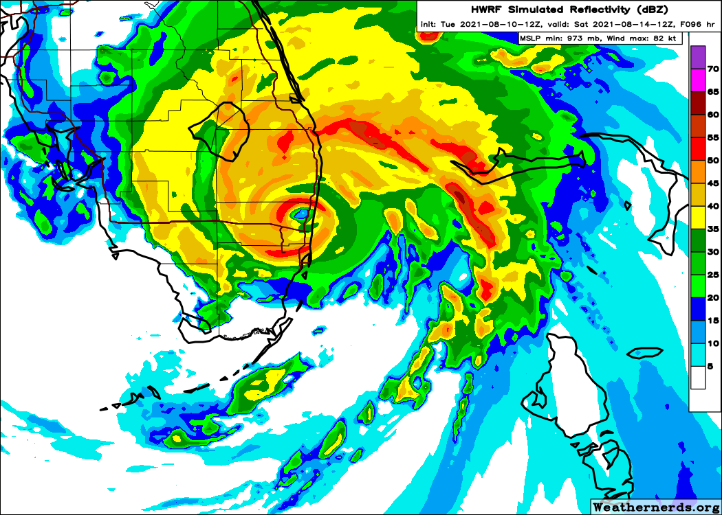
I have no objections with how the HWRF is portraying 06L in the short term. Here's the look at 15z, which is pretty accurate.

0 likes
My posts are my own personal opinion, defer to the National Hurricane Center (NHC) and other NOAA products for decision making during hurricane season.
-
AxaltaRacing24
- Category 5
- Posts: 1774
- Age: 25
- Joined: Wed Jul 27, 2016 11:14 am
- Location: Jupiter, FL
Re: ATL: SIX - Models
IF Fred took that track, I don't think a cat 1 is out of reach at all. It is August in steaming hot water. Notice how the HMON runs straight into every island and STILL landfalls in the 990s.
2 likes
-
jlauderdal
- S2K Supporter
- Posts: 7240
- Joined: Wed May 19, 2004 5:46 am
- Location: NE Fort Lauderdale
- Contact:
Re: ATL: SIX - Models
NHC hasnt shown any interest in the HWRF in terms of track or intensity, check back at 5 and see if they bite on it, i doubt it. The ridging looks good on the consensus.
0 likes
-
StPeteMike

- Category 2

- Posts: 656
- Joined: Thu Jun 07, 2018 11:26 pm
Re: ATL: SIX - Models
The downside with Future Fred not getting its act together before PR and Hispaniola is my description of Hurricane Laura and Elsa , which is that a storm with multiple vortices will not be heavily impacted by land interaction and if a weak center gets disrupted by land, one of the weaker vortices that will likely be off the coast and over water will become the new center pretty easily. Even if it becomes a minimal TS, this will likely still play out.
1 likes
The above post is not official and should not be used as such. It is the opinion of the poster and may or may not be backed by sound meteorological data. It is not endorsed by any professional institution or storm2k.org. For official information, please refer to the NHC and NWS products.
-
ElectricStorm
- Category 5
- Posts: 5148
- Age: 25
- Joined: Tue Aug 13, 2019 11:23 pm
- Location: Norman, OK
Re: ATL: SIX - Models
I don't think this'll come in as strong as the HWRF shows however I'm starting to get a little more concerned now that both intensity models are showing favorable conditions once it clears the islands.
4 likes
B.S Meteorology, University of Oklahoma '25
Please refer to the NHC, NWS, or SPC for official information.
Please refer to the NHC, NWS, or SPC for official information.
Re: ATL: SIX - Models
HMON has a second landfall in the Panhandle near Alligator Point Sunday afternoon. HWRF still has a Tropical Storm exiting to the Gulf north of Tampa then.
0 likes
-
SFLcane
- S2K Supporter
- Posts: 10281
- Age: 48
- Joined: Sat Jun 05, 2010 1:44 pm
- Location: Lake Worth Florida
Re: ATL: SIX - Models
jlauderdal wrote:NHC hasnt shown any interest in the HWRF in terms of track or intensity, check back at 5 and see if they bite on it, i doubt it. The ridging looks good on the consensus.
Here ya, 12z guidance for the most part shifted east.
0 likes


-
AutoPenalti
- Category 5
- Posts: 4091
- Age: 29
- Joined: Mon Aug 17, 2015 4:16 pm
- Location: Ft. Lauderdale, Florida
Re: ATL: SIX - Models
Euro doesn't do much with it in the short term as it still hits DR.
0 likes
The posts in this forum are NOT official forecasts and should not be used as such. They are just the opinion of the poster and may or may not be backed by sound meteorological data. They are NOT endorsed by any professional institution or STORM2K. For official information, please refer to products from the NHC and NWS.
Model Runs Cheat Sheet:
GFS (5:30 AM/PM, 11:30 AM/PM)
HWRF, GFDL, UKMET, NAVGEM (6:30-8:00 AM/PM, 12:30-2:00 AM/PM)
ECMWF (1:45 AM/PM)
TCVN is a weighted averaged
-
tolakram
- Admin
- Posts: 20186
- Age: 62
- Joined: Sun Aug 27, 2006 8:23 pm
- Location: Florence, KY (name is Mark)
Re: ATL: SIX - Models
12Z Euro takes it directly across Hispaniola and then very close to Cuba. Will it also bite on an early NE turn?

0 likes
M a r k
- - - - -
Join us in chat: Storm2K Chatroom Invite. Android and IOS apps also available.
The posts in this forum are NOT official forecasts and should not be used as such. Posts are NOT endorsed by any professional institution or STORM2K.org. For official information and forecasts, please refer to NHC and NWS products.
- - - - -
Join us in chat: Storm2K Chatroom Invite. Android and IOS apps also available.
The posts in this forum are NOT official forecasts and should not be used as such. Posts are NOT endorsed by any professional institution or STORM2K.org. For official information and forecasts, please refer to NHC and NWS products.
-
gatorcane

- S2K Supporter
- Posts: 23708
- Age: 48
- Joined: Sun Mar 13, 2005 3:54 pm
- Location: Boca Raton, FL
Re: ATL: SIX - Models
We need a combined Euro and GFS model graphic on TT. Most of the time, that consensus is correct. In this case the consensus is nowhere close to the HWRF, a model which usually overdoes the intensity.
2 likes

-
nativefloridian

- Tropical Storm

- Posts: 172
- Joined: Tue Aug 21, 2012 2:48 pm
- Location: Pembroke Pines, FL
Re: ATL: SIX - Models
Weather Dude wrote:Shell Mound wrote:Hypercane_Kyle wrote:I will say the potential for a quick episode of rapid intensification right before FL is a little concerning. Conditions do appear more favorable than they were a few days ago.
The good news is that virtually all the guidance agrees that PTC Six will be a small system, reducing the risk of hazards other than wind, and the strongest winds would be limited to a small area. If PTC Six were somehow to “do the impossible” and end up striking Southeast Florida as a deepening hurricane, it would be similar to a storm like Cleo (1964) or Andrew (1992): a storm that will not be memorable outside a very small area that happens to experience the strongest winds. By contrast, a large major hurricane like Wilma or the 1926 Miami hurricane would deliver a greater variety of hazards besides wind to a much larger area.
Andrew was the costliest storm in Atlantic history when it hit at the time. I get what you're saying but the wind damage can still be terrible.
Agreed Weather Dude. With all due respect Shell Mound, the effects of Andrew were felt far more than 30 miles from the eye. I live in Southwest Broward county and the wind damage we experienced was substantial....granted no where near what those in South Dade experienced, but certainly nothing to downplay and certainly a memorable event for all of us in South Florida.
Last edited by nativefloridian on Tue Aug 10, 2021 1:23 pm, edited 1 time in total.
4 likes
Who is online
Users browsing this forum: No registered users and 30 guests