ATL: FRED - Models

Moderator: S2k Moderators

Message
Author
AxaltaRacing24
Category 5
Category 5
Posts: 1753
Age: 25
Joined: Wed Jul 27, 2016 11:14 am
Location: Jupiter, FL

Re: ATL: SIX - Models

#301 Postby AxaltaRacing24 » Tue Aug 10, 2021 12:14 pm

HurricaneFrances04 wrote:Looks like the trend the last few runs has been more north and east. 12z euro will be interesting.

To Louisiana it goes.
0 likes   

AutoPenalti
Category 5
Category 5
Posts: 4030
Age: 29
Joined: Mon Aug 17, 2015 4:16 pm
Location: Ft. Lauderdale, Florida

Re: ATL: SIX - Models

#302 Postby AutoPenalti » Tue Aug 10, 2021 12:14 pm

Now that's hilarious... HWRF literally threading the needle with the Mona Passage scenario. Because of this, it's stronger than 06z
0 likes   
The posts in this forum are NOT official forecasts and should not be used as such. They are just the opinion of the poster and may or may not be backed by sound meteorological data. They are NOT endorsed by any professional institution or STORM2K. For official information, please refer to products from the NHC and NWS.


Model Runs Cheat Sheet:
GFS (5:30 AM/PM, 11:30 AM/PM)
HWRF, GFDL, UKMET, NAVGEM (6:30-8:00 AM/PM, 12:30-2:00 AM/PM)
ECMWF (1:45 AM/PM)

TCVN
is a weighted averaged

User avatar
kevin
Category 5
Category 5
Posts: 2586
Age: 26
Joined: Wed Aug 28, 2019 4:35 am

Re: ATL: SIX - Models

#303 Postby kevin » Tue Aug 10, 2021 12:17 pm

12z HWRF reaches hurricane strength at +54 hrs.

Image
0 likes   

AutoPenalti
Category 5
Category 5
Posts: 4030
Age: 29
Joined: Mon Aug 17, 2015 4:16 pm
Location: Ft. Lauderdale, Florida

Re: ATL: SIX - Models

#304 Postby AutoPenalti » Tue Aug 10, 2021 12:19 pm

kevin wrote:12z HWRF reaches hurricane strength at +54 hrs.

https://i.imgur.com/pVHDJpt.png

Pressure seems right but the windspeed a little too high.
0 likes   
The posts in this forum are NOT official forecasts and should not be used as such. They are just the opinion of the poster and may or may not be backed by sound meteorological data. They are NOT endorsed by any professional institution or STORM2K. For official information, please refer to products from the NHC and NWS.


Model Runs Cheat Sheet:
GFS (5:30 AM/PM, 11:30 AM/PM)
HWRF, GFDL, UKMET, NAVGEM (6:30-8:00 AM/PM, 12:30-2:00 AM/PM)
ECMWF (1:45 AM/PM)

TCVN
is a weighted averaged

Shell Mound
Category 5
Category 5
Posts: 2434
Age: 32
Joined: Thu Sep 07, 2017 3:39 pm
Location: St. Petersburg, FL → Scandinavia

Re: ATL: SIX - Models

#305 Postby Shell Mound » Tue Aug 10, 2021 12:24 pm

AutoPenalti wrote:
kevin wrote:12z HWRF reaches hurricane strength at +54 hrs.

https://i.imgur.com/pVHDJpt.png

Pressure seems right but the windspeed a little too high.

I still don’t think this will become stronger than a low-end TS before impacting South Florida and/or the Keys. The HWRF is suffering from feedback again.
0 likes   
CVW / MiamiensisWx / Shell Mound
The posts in this forum are NOT official forecasts and should not be used as such. They are just the opinion of the poster and may or may not be backed by sound meteorological data. They are NOT endorsed by any professional institution or STORM2K. For official information, please refer to products from the NHC and NWS.

BobHarlem
Category 5
Category 5
Posts: 2105
Joined: Thu Oct 20, 2005 6:11 pm

Re: ATL: SIX - Models

#306 Postby BobHarlem » Tue Aug 10, 2021 12:34 pm

HMON Comes back to life at 84 hours out.
1 likes   

AutoPenalti
Category 5
Category 5
Posts: 4030
Age: 29
Joined: Mon Aug 17, 2015 4:16 pm
Location: Ft. Lauderdale, Florida

Re: ATL: SIX - Models

#307 Postby AutoPenalti » Tue Aug 10, 2021 12:38 pm

HWRF entering the Gulf Stream 984mb.
0 likes   
The posts in this forum are NOT official forecasts and should not be used as such. They are just the opinion of the poster and may or may not be backed by sound meteorological data. They are NOT endorsed by any professional institution or STORM2K. For official information, please refer to products from the NHC and NWS.


Model Runs Cheat Sheet:
GFS (5:30 AM/PM, 11:30 AM/PM)
HWRF, GFDL, UKMET, NAVGEM (6:30-8:00 AM/PM, 12:30-2:00 AM/PM)
ECMWF (1:45 AM/PM)

TCVN
is a weighted averaged

User avatar
GeneratorPower
S2K Supporter
S2K Supporter
Posts: 1648
Age: 45
Joined: Sun Dec 18, 2005 11:48 pm
Location: Huntsville, AL

Re: ATL: SIX - Models

#308 Postby GeneratorPower » Tue Aug 10, 2021 12:38 pm

The HWRF is tracking this system north of the Greater Antilles and keeps center offshore. That's why it's stronger.
1 likes   

User avatar
kevin
Category 5
Category 5
Posts: 2586
Age: 26
Joined: Wed Aug 28, 2019 4:35 am

Re: ATL: SIX - Models

#309 Postby kevin » Tue Aug 10, 2021 12:40 pm

HWRF is doing typical HWRF things. High-end cat 1 Bahamas landfall, 81 kts at +78 hrs. Not saying it's impossible if the true track exactly replicates this run, but seeing as the other models are way less aggressive I'm leaning towards a weaker system than what HWRF is currently showing.

Image
1 likes   

tolakram
Admin
Admin
Posts: 20009
Age: 62
Joined: Sun Aug 27, 2006 8:23 pm
Location: Florence, KY (name is Mark)

Re: ATL: SIX - Models

#310 Postby tolakram » Tue Aug 10, 2021 12:41 pm

HWRF a little too convenient a track, plus

IF (over water) and ( > 48 hours) THEN GO CRAZY!
1 likes   
M a r k
- - - - -
Join us in chat: Storm2K Chatroom Invite. Android and IOS apps also available.

The posts in this forum are NOT official forecasts and should not be used as such. Posts are NOT endorsed by any professional institution or STORM2K.org. For official information and forecasts, please refer to NHC and NWS products.

AutoPenalti
Category 5
Category 5
Posts: 4030
Age: 29
Joined: Mon Aug 17, 2015 4:16 pm
Location: Ft. Lauderdale, Florida

Re: ATL: SIX - Models

#311 Postby AutoPenalti » Tue Aug 10, 2021 12:43 pm

tolakram wrote:HWRF a little too convenient a track, plus

IF (over water) and ( > 48 hours) THEN GO CRAZY!

I think it's more to do with the reformations to the north. It is convenient that it goes between both islands.
0 likes   
The posts in this forum are NOT official forecasts and should not be used as such. They are just the opinion of the poster and may or may not be backed by sound meteorological data. They are NOT endorsed by any professional institution or STORM2K. For official information, please refer to products from the NHC and NWS.


Model Runs Cheat Sheet:
GFS (5:30 AM/PM, 11:30 AM/PM)
HWRF, GFDL, UKMET, NAVGEM (6:30-8:00 AM/PM, 12:30-2:00 AM/PM)
ECMWF (1:45 AM/PM)

TCVN
is a weighted averaged

BobHarlem
Category 5
Category 5
Posts: 2105
Joined: Thu Oct 20, 2005 6:11 pm

Re: ATL: SIX - Models

#312 Postby BobHarlem » Tue Aug 10, 2021 12:43 pm

12Z HMON after it comes back to life after the Hispaniola "splat".

Image
0 likes   

User avatar
SFLcane
S2K Supporter
S2K Supporter
Posts: 10163
Age: 47
Joined: Sat Jun 05, 2010 1:44 pm
Location: Lake Worth Florida

Re: ATL: SIX - Models

#313 Postby SFLcane » Tue Aug 10, 2021 12:44 pm

Look who is coming around even after splashing into islands.

Hmmm..

Image
0 likes   

User avatar
Jr0d
S2K Supporter
S2K Supporter
Posts: 1409
Joined: Tue Aug 27, 2019 10:52 am
Location: Cayo Hueso

Re: ATL: SIX - Models

#314 Postby Jr0d » Tue Aug 10, 2021 12:46 pm

Once again forward speed now makes a big difference on when the turn north will happen. The general trend is a slower storm will turn north further east. The EURO, JMA and to a lesser extent the CMC show the high extending just a little further east and push the storm into the Florida Keys before turning north.

Even 1 mph forward speed difference could mean the difference of turning north into south Florida and limiting time over the water in very favorable conditions or remaining in open water over the Florida Keys while strengthening (perhaps rapidly).

Even a 50 mile difference on the track can make a huge difference.

First thing is Hispaniola, if this system passes just north of the island like the HWRF is showing, then I think the Florida Keys and S. Florida could see a hurricane.

The one thing that is certain is it will be a very small storm until it makes the turn north. This is good for limiting the impacted area but bad because how fast tiny storms can intensify.
0 likes   

User avatar
Blown Away
S2K Supporter
S2K Supporter
Posts: 10145
Joined: Wed May 26, 2004 6:17 am

Re: ATL: SIX - Models

#315 Postby Blown Away » Tue Aug 10, 2021 12:46 pm

Image

12z HWRF 93 Hours... 104 mph Cat 2 Approaching SFL... Slight NE Shift Again.
0 likes   
Hurricane Eye Experience: David 79, Irene 99, Frances 04, Jeanne 04, Wilma 05... EYE COMING MY WAY IN 2024…
Hurricane Brush Experience: Andrew 92, Erin 95, Floyd 99, Matthew 16, Irma 17, Ian 22, Nicole 22…

Shell Mound
Category 5
Category 5
Posts: 2434
Age: 32
Joined: Thu Sep 07, 2017 3:39 pm
Location: St. Petersburg, FL → Scandinavia

Re: ATL: SIX - Models

#316 Postby Shell Mound » Tue Aug 10, 2021 12:47 pm

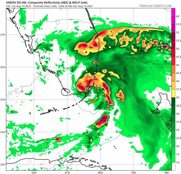
BobHarlem wrote:12Z HMON after it comes back to life after the Hispaniola "splat".

https://i.imgur.com/tAnKc6T.gif

It’s interesting that the HMON shows rapid regeneration and reorganisation over the Gulf Stream and during landfall on Florida, despite the trek over the islands.
0 likes   
CVW / MiamiensisWx / Shell Mound
The posts in this forum are NOT official forecasts and should not be used as such. They are just the opinion of the poster and may or may not be backed by sound meteorological data. They are NOT endorsed by any professional institution or STORM2K. For official information, please refer to products from the NHC and NWS.

User avatar
Hypercane_Kyle
Category 5
Category 5
Posts: 3352
Joined: Sat Mar 07, 2015 7:58 pm
Location: Cape Canaveral, FL

Re: ATL: SIX - Models

#317 Postby Hypercane_Kyle » Tue Aug 10, 2021 12:50 pm

I will say the potential for a quick episode of rapid intensification right before FL is a little concerning. Conditions do appear more favorable than they were a few days ago.
3 likes   
My posts are my own personal opinion, defer to the National Hurricane Center (NHC) and other NOAA products for decision making during hurricane season.

User avatar
Blown Away
S2K Supporter
S2K Supporter
Posts: 10145
Joined: Wed May 26, 2004 6:17 am

Re: ATL: SIX - Models

#318 Postby Blown Away » Tue Aug 10, 2021 12:52 pm

Image
12z HWRF 96 Hours... Landfall Miami/FTL Winds >100 mph... Slight NE Shift Again.
0 likes   
Hurricane Eye Experience: David 79, Irene 99, Frances 04, Jeanne 04, Wilma 05... EYE COMING MY WAY IN 2024…
Hurricane Brush Experience: Andrew 92, Erin 95, Floyd 99, Matthew 16, Irma 17, Ian 22, Nicole 22…

BobHarlem
Category 5
Category 5
Posts: 2105
Joined: Thu Oct 20, 2005 6:11 pm

Re: ATL: SIX - Models

#319 Postby BobHarlem » Tue Aug 10, 2021 12:52 pm

HWRF with a high end Cat 2 to Dania Beach/Ft. Lauderdale Saturday morning.
0 likes   

AutoPenalti
Category 5
Category 5
Posts: 4030
Age: 29
Joined: Mon Aug 17, 2015 4:16 pm
Location: Ft. Lauderdale, Florida

Re: ATL: SIX - Models

#320 Postby AutoPenalti » Tue Aug 10, 2021 12:53 pm

HWRF decimates Broward.
0 likes   
The posts in this forum are NOT official forecasts and should not be used as such. They are just the opinion of the poster and may or may not be backed by sound meteorological data. They are NOT endorsed by any professional institution or STORM2K. For official information, please refer to products from the NHC and NWS.


Model Runs Cheat Sheet:
GFS (5:30 AM/PM, 11:30 AM/PM)
HWRF, GFDL, UKMET, NAVGEM (6:30-8:00 AM/PM, 12:30-2:00 AM/PM)
ECMWF (1:45 AM/PM)

TCVN
is a weighted averaged


Return to “2021”

Who is online

Users browsing this forum: No registered users and 6 guests