ATL: GRACE - Remnants - Discussion
Moderator: S2k Moderators
-
jlauderdal
- S2K Supporter

- Posts: 7240
- Joined: Wed May 19, 2004 5:46 am
- Location: NE Fort Lauderdale
- Contact:
Re: ATL: SEVEN - Tropical Depression - Discussion
Very interesting few days ahead for Grace as it does have hurdles in its way but the modeling has been so poor that if it can stay off the islands there are real possibilities regardless of the shear forecast, shear forecasts are as iffy as the hwrf. I'm off to the high mountains of colorado 9000+ with no intention of coming back early which means SE Florida is in the crosshairs for something big 
0 likes
-
AlphaToOmega
- Category 5

- Posts: 1448
- Joined: Sat Jun 26, 2021 10:51 am
- Location: Somewhere in Massachusetts
Re: ATL: GRACE - Tropical Storm - Discussion
Tropical Storm Grace is moving 19 knots westward. I do not expected it to strengthen much over the next few days. The Gulf of Mexico seems like the most favorable place for intensification.
0 likes
-
HuracanMaster
- Tropical Low

- Posts: 45
- Joined: Sat Aug 08, 2020 11:20 am
Re: ATL: SEVEN - Tropical Depression - Discussion
Shell Mound wrote:https://twitter.com/JohnConwaywx/status/1426465026836160512...the intensity forecast
becomes somewhat complicated as the system is forecast to interact
with an upper-level trough while possibly crossing the Greater
Antilles at the same time. Slight weakening is indicated in the NHC
intensity forecast as the system crosses the northern portion of the
Dominican Republic early next week. Thereafter, moderate to strong
northerly shear is forecast to impact Grace as the system moves into
the flow on the western side of an upper-level trough over the
western Atlantic. This shear should prevent any further
strengthening through the end of the forecast period. The intensity
forecast is a little lower than a blend of the NOAA HCCA and IVCN
consensus, as there is likely a high bias from the HWRF in these
solutions. The latter portion of the NHC intensity forecast is of
lower-than-normal confidence due to the potential for a longer
amount of time over the rugged terrain of the Greater Antilles than
indicated, and also due to the fragile nature of the small cyclone
and the possible effects of the stronger shear later in the
forecast period.
Small cyclone that also are subject to sudden burst of intesity up and down. HWRF has me worried, 978 mb entering PR.
0 likes

Re: ATL: SEVEN - Tropical Depression - Discussion
HuracanMaster wrote:Shell Mound wrote:https://twitter.com/JohnConwaywx/status/1426465026836160512...the intensity forecast
becomes somewhat complicated as the system is forecast to interact
with an upper-level trough while possibly crossing the Greater
Antilles at the same time. Slight weakening is indicated in the NHC
intensity forecast as the system crosses the northern portion of the
Dominican Republic early next week. Thereafter, moderate to strong
northerly shear is forecast to impact Grace as the system moves into
the flow on the western side of an upper-level trough over the
western Atlantic. This shear should prevent any further
strengthening through the end of the forecast period. The intensity
forecast is a little lower than a blend of the NOAA HCCA and IVCN
consensus, as there is likely a high bias from the HWRF in these
solutions. The latter portion of the NHC intensity forecast is of
lower-than-normal confidence due to the potential for a longer
amount of time over the rugged terrain of the Greater Antilles than
indicated, and also due to the fragile nature of the small cyclone
and the possible effects of the stronger shear later in the
forecast period.
Small cyclone that also are subject to sudden burst of intesity up and down. HWRF has me worried, 978 mb entering PR.
The first thing that popped into my head was my girlfriends cockatiel "foot" she bought from a retired CIA agent.
Might mean a more northerly track with the Mona Passage in play but that is just intuition.
NHC seems to think there might be more land interaction with Hispaniola.
Its avery nebulous walk through the forest at this point.
0 likes

Re: ATL: GRACE - Tropical Storm - Discussion
Quite blobby this morning, but convection is deep and healthy looking. Still have no idea when recon is supposed to get there.
0 likes
Irene '11 Sandy '12 Hermine '16 5/15/2018 Derecho Fay '20 Isaias '20 Elsa '21 Henri '21 Ida '21
I am only a meteorology enthusiast who knows a decent amount about tropical cyclones. Look to the professional mets, the NHC, or your local weather office for the best information.
I am only a meteorology enthusiast who knows a decent amount about tropical cyclones. Look to the professional mets, the NHC, or your local weather office for the best information.

Re: ATL: GRACE - Tropical Storm - Discussion
Another tricky forecast ahead. I can see the NHC being very conveservative based on the two previous systems taking a similar track and atmospheric conditions.
But I keep saying one these days the HWRF is going to be right and bite us all
But I keep saying one these days the HWRF is going to be right and bite us all
0 likes
-
AlphaToOmega
- Category 5
- Posts: 1448
- Joined: Sat Jun 26, 2021 10:51 am
- Location: Somewhere in Massachusetts
Re: ATL: GRACE - Tropical Storm - Discussion
The latest operational GFS run has Tropical Storm Grace as a 985-millibar hurricane making landfall around Tampa.
0 likes
-
gatorcane

- S2K Supporter
- Posts: 23708
- Age: 48
- Joined: Sun Mar 13, 2005 3:54 pm
- Location: Boca Raton, FL
Re: ATL: GRACE - Tropical Storm - Discussion
AlphaToOmega wrote:The latest operational GFS run has Tropical Storm Grace as a 985-millibar hurricane making landfall around Tampa.
Bearish GFS ensembles though, I posted an image in the models thread
0 likes
-
USVIKimmie

- Tropical Depression

- Posts: 51
- Joined: Fri Sep 07, 2018 10:12 pm
Re: ATL: GRACE - Tropical Storm - Discussion
I'm nowhere near a pro at this, but living with it in the USVI for close to 20 years, I've learned to trust my tools (and wxman57 ). There's a wind app that's eerily accurate and it's forecasting 45-60 for the station closest to me, and St Croix getting 30-40kts. This wavering from the NHC is similar to how they totally got Dorian wrong - it went Cat 1 in Charlotte Amalie harbor (had friends on boats registered 100+ on wind instruments). Gotta love Boat Life (not always)
1 likes
Re: ATL: GRACE - Tropical Storm - Discussion
Very important the Latitude where Grace's LLC is and determing whether it tracks over Hispaniola or not, which is its biggest obstacle, IMO.

0 likes
-
Yellow Evan

- Professional-Met

- Posts: 16242
- Age: 27
- Joined: Fri Jul 15, 2011 12:48 pm
- Location: Henderson, Nevada/Honolulu, HI
- Contact:
Re: ATL: GRACE - Tropical Storm - Discussion
TXNT22 KNES 141151
TCSNTL
A. 07L (GRACE)
B. 14/1130Z
C. 15.9N
D. 56.4W
E. THREE/GOES-E
F. T2.5/3.0
G. IR/EIR/VIS
H. REMARKS...CENTER IS EMBEDDED <1/3 DEG INTO A LARGE COLD OVC RESULTING
IN A DT OF 3.5. MET AND PT=2.5. SYSTEM APPEARS TO BE IMPACTED BY SOME
SHEAR DUE TO FAST FORWARD MOTION. FT IS BASED ON MET DUE TO
PULSING/IRREG CONVECTION.
I. ADDL POSITIONS
NIL
...KONON
Why is SAB not using DT lately?
0 likes
Re: ATL: GRACE - Tropical Storm - Discussion
Convection is very deep over the center (<-75C), and it seems like there’s some primitive banding on visible imagery. I think Grace is already stronger than forecast and might be closer to 45-50 kt by the time recon arrives later this afternoon.
5 likes
Irene '11 Sandy '12 Hermine '16 5/15/2018 Derecho Fay '20 Isaias '20 Elsa '21 Henri '21 Ida '21
I am only a meteorology enthusiast who knows a decent amount about tropical cyclones. Look to the professional mets, the NHC, or your local weather office for the best information.
I am only a meteorology enthusiast who knows a decent amount about tropical cyclones. Look to the professional mets, the NHC, or your local weather office for the best information.
-
Yellow Evan
- Professional-Met
- Posts: 16242
- Age: 27
- Joined: Fri Jul 15, 2011 12:48 pm
- Location: Henderson, Nevada/Honolulu, HI
- Contact:
Re: ATL: GRACE - Tropical Storm - Discussion
Looks much better this morning with a defined curved band and a CDO. This development was not anticipated by models but given the low shear predicted it’s also not that much of a surprise.
0 likes


Re: ATL: GRACE - Tropical Storm - Discussion
Grace certainly has the look of a healthy developing cyclone this morning. With little shear in the short term I could definitely see this ramping up pretty fast before PR. It's hard to believe we really have a 3rd storm that might dance with Hispaniola and it's only August 13th.
0 likes


-
InfernoFlameCat

- Category 5
- Posts: 2127
- Age: 22
- Joined: Mon Dec 14, 2020 10:52 am
- Location: Buford, GA
Re: ATL: GRACE - Tropical Storm - Discussion
We could get a short RI phase here. Very good looking with deep organized convection and a prominent feeder band to its west.
0 likes
I am by no means a professional. DO NOT look at my forecasts for official information or make decisions based on what I post.
Goal: to become a registered expert over tropical and subtropical cyclones.
Goal: to become a registered expert over tropical and subtropical cyclones.
-
Hypercane_Kyle

- Category 5
- Posts: 3465
- Joined: Sat Mar 07, 2015 7:58 pm
- Location: Cape Canaveral, FL
Re: ATL: GRACE - Tropical Storm - Discussion
Looks decent, but we all know that doesn't always correlate with an organized system. What's under the hood is what matters.

9 likes
My posts are my own personal opinion, defer to the National Hurricane Center (NHC) and other NOAA products for decision making during hurricane season.
-
AlphaToOmega
- Category 5
- Posts: 1448
- Joined: Sat Jun 26, 2021 10:51 am
- Location: Somewhere in Massachusetts
Re: ATL: GRACE - Tropical Storm - Discussion
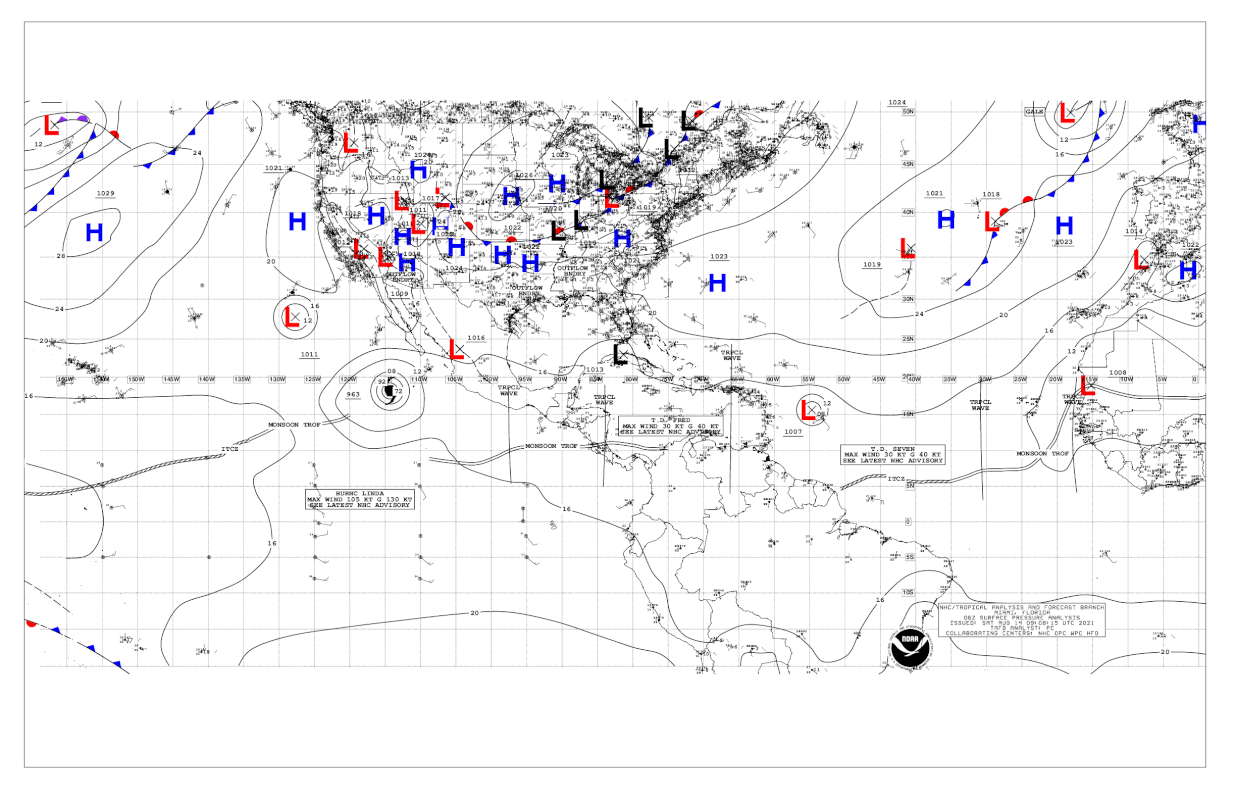
On the 06Z surface analysis, I see two circular isobars around Tropical Storm Grace. This is definitely healthy right now.
0 likes
-
InfernoFlameCat
- Category 5
- Posts: 2127
- Age: 22
- Joined: Mon Dec 14, 2020 10:52 am
- Location: Buford, GA
Re: ATL: GRACE - Tropical Storm - Discussion
Hypercane_Kyle wrote:Looks decent, but we all know that doesn't always correlate with an organized system. What's under the hood is what matters.
https://i.imgur.com/uE3TuUC.jpg
The microwave pass showed an organized llc under the convection. I think she is at 50 knots
0 likes
I am by no means a professional. DO NOT look at my forecasts for official information or make decisions based on what I post.
Goal: to become a registered expert over tropical and subtropical cyclones.
Goal: to become a registered expert over tropical and subtropical cyclones.
Re: ATL: GRACE - Tropical Storm - Discussion
The 12z best track puts Grace’s LLC at 57.0W, a little east of the main convective blob, so it doesn’t seem to be fully lined-up with convection just yet. We’ll have to wait for recon this afternoon to truly know what it’s like under the hood.
1 likes
Irene '11 Sandy '12 Hermine '16 5/15/2018 Derecho Fay '20 Isaias '20 Elsa '21 Henri '21 Ida '21
I am only a meteorology enthusiast who knows a decent amount about tropical cyclones. Look to the professional mets, the NHC, or your local weather office for the best information.
I am only a meteorology enthusiast who knows a decent amount about tropical cyclones. Look to the professional mets, the NHC, or your local weather office for the best information.
Who is online
Users browsing this forum: No registered users and 13 guests