ATL: SAM - Models

Moderator: S2k Moderators

Message
Author
User avatar
Blown Away
S2K Supporter
S2K Supporter
Posts: 10145
Joined: Wed May 26, 2004 6:17 am

Re: ATL: INVEST 98L - Models

#241 Postby Blown Away » Tue Sep 21, 2021 1:12 pm

kevin wrote:
tolakram wrote:delaying development.

https://i.imgur.com/XD8Wesv.png


Unless it doesn't develop at all, later development would be bad for possible Caribbean/CONUS impacts since it would less time to recurve right?


Initially, for the NE Caribbean, yes it seems the chances increase for a more WNW track with an impact/close call for the NE Caribbean if 98L takes a bit longer to develop. CONUS impacts is way to early to know and climatology is heavily against a WNW system from the MDR moving into CONUS in October.
2 likes   
Hurricane Eye Experience: David 79, Irene 99, Frances 04, Jeanne 04, Wilma 05... EYE COMING MY WAY IN 2024…
Hurricane Brush Experience: Andrew 92, Erin 95, Floyd 99, Matthew 16, Irma 17, Ian 22, Nicole 22…

IcyTundra
Category 5
Category 5
Posts: 1205
Joined: Mon Jun 07, 2021 9:32 pm
Location: Dickinson, Texas

Re: ATL: INVEST 98L - Models

#242 Postby IcyTundra » Tue Sep 21, 2021 1:14 pm

This has more model support than Peter ever had. It may not develop as fast as the models are showing, but I don't think this will be Peter 2.0.
Last edited by IcyTundra on Tue Sep 21, 2021 1:15 pm, edited 1 time in total.
2 likes   

grapealcoholic
Category 2
Category 2
Posts: 684
Joined: Tue Aug 10, 2021 3:26 pm

Re: ATL: INVEST 98L - Models

#243 Postby grapealcoholic » Tue Sep 21, 2021 1:15 pm

If there is something spinning over the Bahamas, it's going to develop.

Also, HWRF keeps coming in stronger every run lol

Image
0 likes   

User avatar
aspen
Category 5
Category 5
Posts: 8818
Joined: Sat Oct 12, 2019 7:10 pm
Location: Connecticut, USA

Re: ATL: INVEST 98L - Models

#244 Postby aspen » Tue Sep 21, 2021 1:19 pm

HWRF is down to 956mb @105hr, and is even further south than last run, at 12/13N by the time it reaches 50W. This will put it over a tongue of 29.5-30.0C SSTs and help it RI into a major, and make it more likely to be a problem for the Caribbean. However, the HWRF is often either the furthest SW or the furthest NE model at various points in a storm’s life; 14N-15N @50W seems more probable as of now.

The frames past 105hr have not loaded yet for some reason.
0 likes   
Irene '11 Sandy '12 Hermine '16 5/15/2018 Derecho Fay '20 Isaias '20 Elsa '21 Henri '21 Ida '21

I am only a meteorology enthusiast who knows a decent amount about tropical cyclones. Look to the professional mets, the NHC, or your local weather office for the best information.

AutoPenalti
Category 5
Category 5
Posts: 4030
Age: 29
Joined: Mon Aug 17, 2015 4:16 pm
Location: Ft. Lauderdale, Florida

Re: ATL: INVEST 98L - Models

#245 Postby AutoPenalti » Tue Sep 21, 2021 1:20 pm

Blown Away wrote:
kevin wrote:
tolakram wrote:delaying development.

https://i.imgur.com/XD8Wesv.png


Unless it doesn't develop at all, later development would be bad for possible Caribbean/CONUS impacts since it would less time to recurve right?


Initially, for the NE Caribbean, yes it seems the chances increase for a more WNW track with an impact/close call for the NE Caribbean if 98L takes a bit longer to develop. CONUS impacts is way to early to know and climatology is heavily against a WNW system from the MDR moving into CONUS in October.

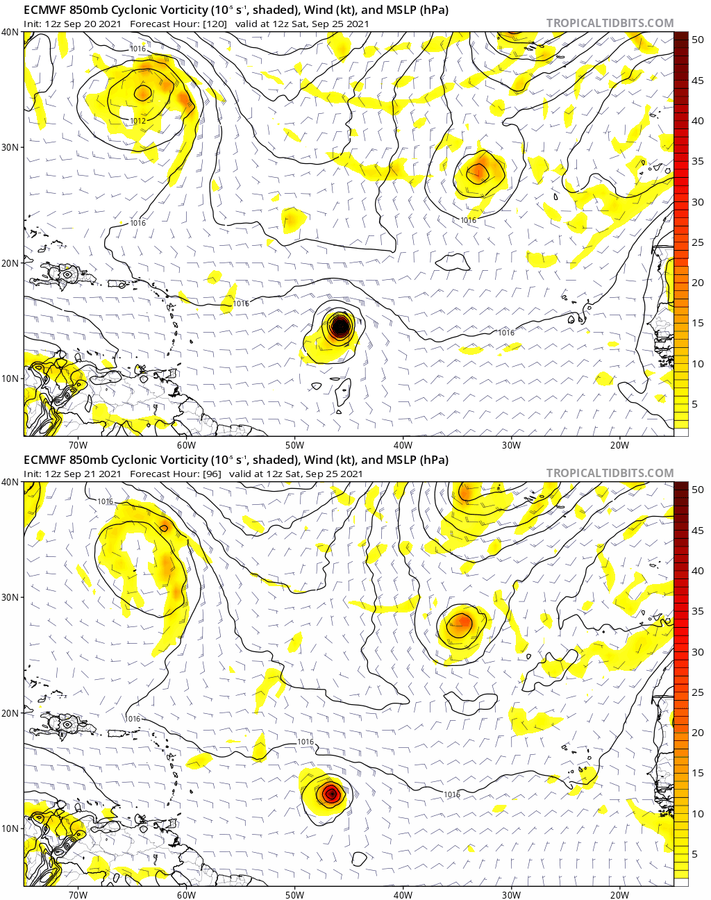
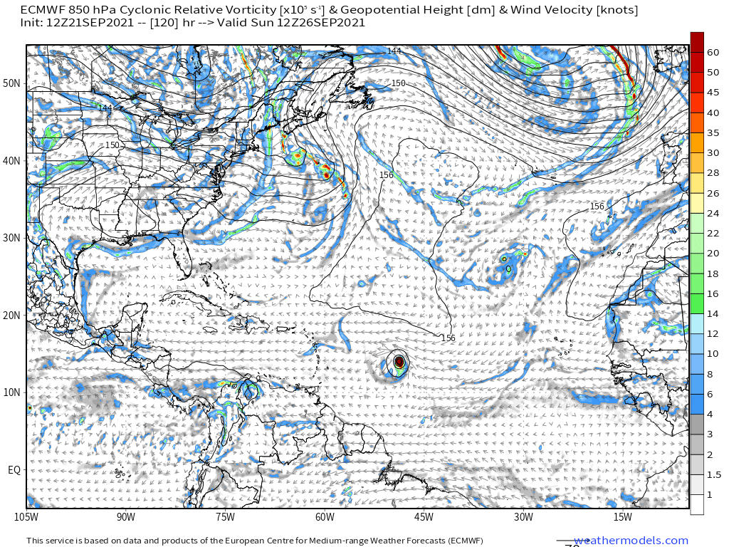
Euro slightly more south of 0z.
0 likes   
The posts in this forum are NOT official forecasts and should not be used as such. They are just the opinion of the poster and may or may not be backed by sound meteorological data. They are NOT endorsed by any professional institution or STORM2K. For official information, please refer to products from the NHC and NWS.


Model Runs Cheat Sheet:
GFS (5:30 AM/PM, 11:30 AM/PM)
HWRF, GFDL, UKMET, NAVGEM (6:30-8:00 AM/PM, 12:30-2:00 AM/PM)
ECMWF (1:45 AM/PM)

TCVN
is a weighted averaged

User avatar
Blown Away
S2K Supporter
S2K Supporter
Posts: 10145
Joined: Wed May 26, 2004 6:17 am

Re: ATL: INVEST 98L - Models

#246 Postby Blown Away » Tue Sep 21, 2021 1:20 pm

Image
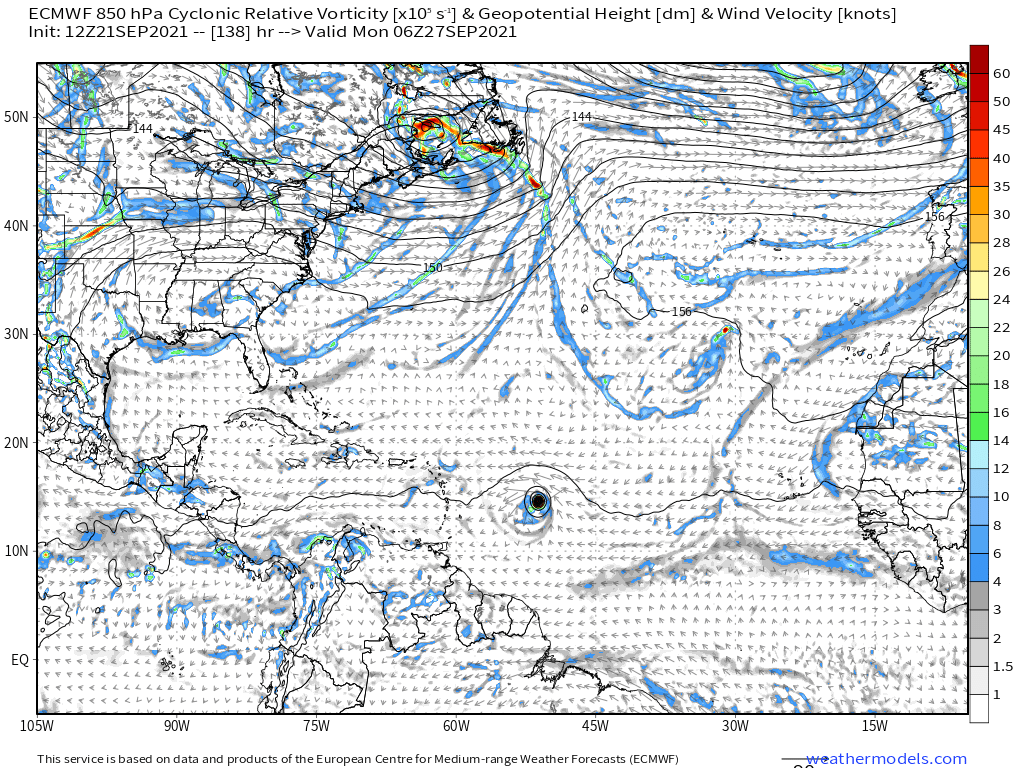
12z EURO through 96 hours is a tad weaker and SW, thinking a run onto the NE Caribbean in the future for this EURO run...
0 likes   
Hurricane Eye Experience: David 79, Irene 99, Frances 04, Jeanne 04, Wilma 05... EYE COMING MY WAY IN 2024…
Hurricane Brush Experience: Andrew 92, Erin 95, Floyd 99, Matthew 16, Irma 17, Ian 22, Nicole 22…

grapealcoholic
Category 2
Category 2
Posts: 684
Joined: Tue Aug 10, 2021 3:26 pm

Re: ATL: INVEST 98L - Models

#247 Postby grapealcoholic » Tue Sep 21, 2021 1:22 pm

This is an interesting sounding from HWRF. Seems like a stronger storm would feel more easterly or perhaps even northeasterly flow

Image
0 likes   

tolakram
Admin
Admin
Posts: 20009
Age: 62
Joined: Sun Aug 27, 2006 8:23 pm
Location: Florence, KY (name is Mark)

Re: ATL: INVEST 98L - Models

#248 Postby tolakram » Tue Sep 21, 2021 1:22 pm

A lot weaker.

Image
0 likes   
M a r k
- - - - -
Join us in chat: Storm2K Chatroom Invite. Android and IOS apps also available.

The posts in this forum are NOT official forecasts and should not be used as such. Posts are NOT endorsed by any professional institution or STORM2K.org. For official information and forecasts, please refer to NHC and NWS products.

User avatar
SFLcane
S2K Supporter
S2K Supporter
Posts: 10163
Age: 47
Joined: Sat Jun 05, 2010 1:44 pm
Location: Lake Worth Florida

Re: ATL: INVEST 98L - Models

#249 Postby SFLcane » Tue Sep 21, 2021 1:23 pm

Image
0 likes   

grapealcoholic
Category 2
Category 2
Posts: 684
Joined: Tue Aug 10, 2021 3:26 pm

Re: ATL: INVEST 98L - Models

#250 Postby grapealcoholic » Tue Sep 21, 2021 1:25 pm

:double:

Image
0 likes   

User avatar
SFLcane
S2K Supporter
S2K Supporter
Posts: 10163
Age: 47
Joined: Sat Jun 05, 2010 1:44 pm
Location: Lake Worth Florida

Re: ATL: INVEST 98L - Models

#251 Postby SFLcane » Tue Sep 21, 2021 1:26 pm

Image
1 likes   

User avatar
aspen
Category 5
Category 5
Posts: 8818
Joined: Sat Oct 12, 2019 7:10 pm
Location: Connecticut, USA

Re: ATL: INVEST 98L - Models

#252 Postby aspen » Tue Sep 21, 2021 1:30 pm

120kt/944mb Cat 4 Hurricane Sam by Sunday afternoon on the HWRF :double:

98L has some huge potential if it takes an HWRF-like track that remains south of 15N prior to reaching 55W. It might even get into the eastern Caribbean if it stays that low.
0 likes   
Irene '11 Sandy '12 Hermine '16 5/15/2018 Derecho Fay '20 Isaias '20 Elsa '21 Henri '21 Ida '21

I am only a meteorology enthusiast who knows a decent amount about tropical cyclones. Look to the professional mets, the NHC, or your local weather office for the best information.

User avatar
SFLcane
S2K Supporter
S2K Supporter
Posts: 10163
Age: 47
Joined: Sat Jun 05, 2010 1:44 pm
Location: Lake Worth Florida

Re: ATL: INVEST 98L - Models

#253 Postby SFLcane » Tue Sep 21, 2021 1:30 pm

Image
0 likes   

IcyTundra
Category 5
Category 5
Posts: 1205
Joined: Mon Jun 07, 2021 9:32 pm
Location: Dickinson, Texas

Re: ATL: INVEST 98L - Models

#254 Postby IcyTundra » Tue Sep 21, 2021 1:30 pm

tolakram wrote:A lot weaker.

https://i.imgur.com/5WcING9.png


We will see if you are right about the delayed development. I can see why you think this could turn out to be Peter 2.0 as development is indeed being pushed back a bit, but I'm trying to remember if the model support was this strong for Peter after it emerged off the coast of Africa.
1 likes   

grapealcoholic
Category 2
Category 2
Posts: 684
Joined: Tue Aug 10, 2021 3:26 pm

Re: ATL: INVEST 98L - Models

#255 Postby grapealcoholic » Tue Sep 21, 2021 1:31 pm

HWRF never turned Peter into a Cat 4 beast, that's for sure
2 likes   

AutoPenalti
Category 5
Category 5
Posts: 4030
Age: 29
Joined: Mon Aug 17, 2015 4:16 pm
Location: Ft. Lauderdale, Florida

Re: ATL: INVEST 98L - Models

#256 Postby AutoPenalti » Tue Sep 21, 2021 1:32 pm

This is starting to remind me of Elsa and Grace to some degree.
0 likes   
The posts in this forum are NOT official forecasts and should not be used as such. They are just the opinion of the poster and may or may not be backed by sound meteorological data. They are NOT endorsed by any professional institution or STORM2K. For official information, please refer to products from the NHC and NWS.


Model Runs Cheat Sheet:
GFS (5:30 AM/PM, 11:30 AM/PM)
HWRF, GFDL, UKMET, NAVGEM (6:30-8:00 AM/PM, 12:30-2:00 AM/PM)
ECMWF (1:45 AM/PM)

TCVN
is a weighted averaged

User avatar
kevin
Category 5
Category 5
Posts: 2586
Age: 26
Joined: Wed Aug 28, 2019 4:35 am

Re: ATL: INVEST 98L - Models

#257 Postby kevin » Tue Sep 21, 2021 1:34 pm

12z HWRF track with dots every 6 hours. Green dot indicates when HWRF consistently reaches TS level, the yellow dot indicates hurricane level and the red dot MH. HWRF ends 98L at +126 as a cat 4.

Image
3 likes   

User avatar
Iceresistance
Category 5
Category 5
Posts: 9288
Age: 21
Joined: Sat Oct 10, 2020 9:45 am
Location: Tecumseh, OK/Norman, OK

Re: ATL: INVEST 98L - Models

#258 Postby Iceresistance » Tue Sep 21, 2021 1:36 pm

If the WNW Steering is verified (Shown in the 12z HWRF sounding), the Lesser Antilles needs to keep an close eye on this . . .

Image
1 likes   
Bill 2015 & Beta 2020

Winter 2020-2021 :cold:

All observations are in Tecumseh, OK unless otherwise noted.

Winter posts are focused mainly for Oklahoma & Texas.

Take any of my forecasts with a grain of salt, refer to the NWS, SPC, and NHC for official information

Never say Never with weather! Because ANYTHING is possible!

User avatar
aspen
Category 5
Category 5
Posts: 8818
Joined: Sat Oct 12, 2019 7:10 pm
Location: Connecticut, USA

Re: ATL: INVEST 98L - Models

#259 Postby aspen » Tue Sep 21, 2021 1:37 pm

IcyTundra wrote:
tolakram wrote:A lot weaker.

https://i.imgur.com/5WcING9.png


We will see if you are right about the delayed development. I can see why you think this could turn out to be Peter 2.0 as development is indeed being pushed back a bit, but I'm trying to remember if the model support was this strong for Peter after it emerged off the coast of Africa.

This is much better than Peter. The Euro was the main model developing 95L for a while and constantly had its forecasts of rapid genesis pushed back. At this point, the GFS was flip-flopping between something and nothing, and the HWRF was wildly inconsistent as well. I think the CMC and ICON were occasionally showing hurricanes.

Peter never had the GFS, GEFS, Euro, EPS, CMC, ICON, HMON, and HWRF in such a strong agreement for a possible long-tracking major. No run develops it unreasonably quickly either.
4 likes   
Irene '11 Sandy '12 Hermine '16 5/15/2018 Derecho Fay '20 Isaias '20 Elsa '21 Henri '21 Ida '21

I am only a meteorology enthusiast who knows a decent amount about tropical cyclones. Look to the professional mets, the NHC, or your local weather office for the best information.

grapealcoholic
Category 2
Category 2
Posts: 684
Joined: Tue Aug 10, 2021 3:26 pm

Re: ATL: INVEST 98L - Models

#260 Postby grapealcoholic » Tue Sep 21, 2021 1:39 pm

Iceresistance wrote:If the WNW Steering is verified (Shown in the 12z HWRF sounding), the Lesser Antilles needs to keep an close eye on this . . .

https://s9.gifyu.com/images/hwrf_2021092112_fh126_sounding_13.33N_51.66W.png

Might just be HWRF silliness but this is surprising -- would have expected a storm that strong to be gaining more latitude
0 likes   


Return to “2021”

Who is online

Users browsing this forum: No registered users and 4 guests