CPAC: LINDA - Post-Tropical
Moderator: S2k Moderators
-
Yellow Evan

- Professional-Met

- Posts: 16242
- Age: 27
- Joined: Fri Jul 15, 2011 12:48 pm
- Location: Henderson, Nevada/Honolulu, HI
- Contact:
Re: EPAC: LINDA - Hurricane
With the eye not closed and the CDO thin, let’s pump the breaks on Category 4.
3 likes
-
Sciencerocks
- Category 5

- Posts: 10186
- Age: 40
- Joined: Thu Jul 06, 2017 1:51 am


Re: EPAC: LINDA - Hurricane
Is that island inhabited? Is it large enough to somewhat weaken the storm?
0 likes
Personal Forecast Disclaimer:
The posts in this forum are NOT official forecast and should not be used as such. They are just the opinion of the poster and may or may not be backed by sound meteorological data. For official information, please refer to the NHC and NWS products.
The posts in this forum are NOT official forecast and should not be used as such. They are just the opinion of the poster and may or may not be backed by sound meteorological data. For official information, please refer to the NHC and NWS products.
-
Shell Mound
- Category 5
- Posts: 2432
- Age: 33
- Joined: Thu Sep 07, 2017 3:39 pm
- Location: St. Petersburg, FL → Scandinavia
Re: EPAC: LINDA - Hurricane
sikkar wrote:Is that island inhabited? Is it large enough to somewhat weaken the storm?
That island is Isla Clarión (Clarion Island), westernmost of the Revillagigedo Archipelago, which includes Socorro. Given the absence of freshwater reservoirs on the island, only a relative handful of people reside on Clarion. Given the island’s small size, it would not affect the intensity of Linda to any significant degree. Aside from a military presence, the island itself is virtually uninhabited, and I am unsure as to whether meteorological instrumentation is stationed on the island.
2 likes
CVW / MiamiensisWx / Shell Mound
The posts in this forum are NOT official forecasts and should not be used as such. They are just the opinion of the poster and may or may not be backed by sound meteorological data. They are NOT endorsed by any professional institution or STORM2K. For official information, please refer to products from the NHC and NWS.
-
Yellow Evan
- Professional-Met
- Posts: 16242
- Age: 27
- Joined: Fri Jul 15, 2011 12:48 pm
- Location: Henderson, Nevada/Honolulu, HI
- Contact:

-
Yellow Evan
- Professional-Met
- Posts: 16242
- Age: 27
- Joined: Fri Jul 15, 2011 12:48 pm
- Location: Henderson, Nevada/Honolulu, HI
- Contact:
Re: EPAC: LINDA - Hurricane
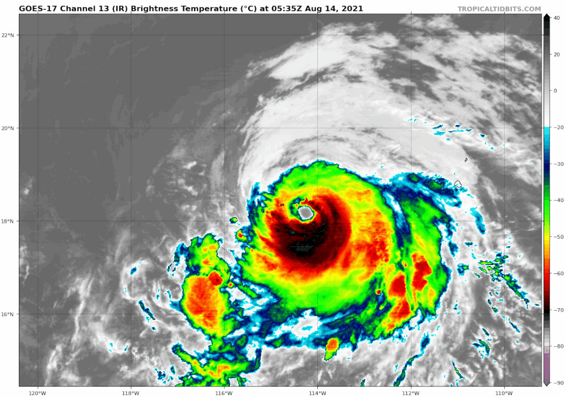
----- Current Analysis -----
Date : 14 AUG 2021 Time : 074535 UTC
Lat : 18:22:47 N Lon : 114:37:47 W
CI# /Pressure/ Vmax
5.4 / 960.9mb/ 99.6kt
Final T# Adj T# Raw T#
5.4 6.0 6.0
Estimated radius of max. wind based on IR : 19 km
Center Temp : +12.7C Cloud Region Temp : -64.8C
Scene Type : EYE
Date : 14 AUG 2021 Time : 074535 UTC
Lat : 18:22:47 N Lon : 114:37:47 W
CI# /Pressure/ Vmax
5.4 / 960.9mb/ 99.6kt
Final T# Adj T# Raw T#
5.4 6.0 6.0
Estimated radius of max. wind based on IR : 19 km
Center Temp : +12.7C Cloud Region Temp : -64.8C
Scene Type : EYE
0 likes
-
Shell Mound
- Category 5
- Posts: 2432
- Age: 33
- Joined: Thu Sep 07, 2017 3:39 pm
- Location: St. Petersburg, FL → Scandinavia
Re: EPAC: LINDA - Hurricane
A wind gust to 106 mph (170 km/h) was recently measured
by a Mexican Navy weather observation site on Clarion Island.
Source
Does anyone have a link to live observations from Clarion?
0 likes
CVW / MiamiensisWx / Shell Mound
The posts in this forum are NOT official forecasts and should not be used as such. They are just the opinion of the poster and may or may not be backed by sound meteorological data. They are NOT endorsed by any professional institution or STORM2K. For official information, please refer to products from the NHC and NWS.
-
Yellow Evan
- Professional-Met
- Posts: 16242
- Age: 27
- Joined: Fri Jul 15, 2011 12:48 pm
- Location: Henderson, Nevada/Honolulu, HI
- Contact:
Re: EPAC: LINDA - Hurricane
Shell Mound wrote:A wind gust to 106 mph (170 km/h) was recently measured
by a Mexican Navy weather observation site on Clarion Island.
Source
Does anyone have a link to live observations from Clarion?
Not able to access it on the Mexican national weather service site unfortunately.
0 likes
-
Yellow Evan
- Professional-Met
- Posts: 16242
- Age: 27
- Joined: Fri Jul 15, 2011 12:48 pm
- Location: Henderson, Nevada/Honolulu, HI
- Contact:
Re: EPAC: LINDA - Hurricane
234
WTPZ42 KNHC 140849
TCDEP2
Hurricane Linda Discussion Number 17
NWS National Hurricane Center Miami FL EP122021
300 AM MDT Sat Aug 14 2021
Earlier conventional satellite imagery and a F-17/SSMIS microwave
image revealed some deterioration of Linda's eyewall in the
northwest quadrant, and some cooling of the eye. However, the
latest few BD-curve enhanced infrared images show a quickly
developing solid black ring of -69 to -73C temperatures associated
with Linda's eye wall. Based on these recent convective trends and
a special Dvorak satellite intensity classification from TAFB, the
initial intensity is raised to 110 kt.
Little change in strength is expected today, other than some
possible slight fluctuations. By early Sunday, the hurricane
should be moving over gradually decreasing sea surface temperatures
and into a more stable and drier (700-500 mb relative humidity of
about 53 percent) thermodynamic surrounding environment. These
inhibiting conditions are expected to induce a steady weakening
trend through day 3. Beyond that period, Linda should weaken more
rapidly as it moves over even cooler (sub 24C) oceanic temperatures.
The official intensity forecast is merely an update of the previous
advisory, and is in best agreement with the various multi-model
intensity consensus guidance.
The initial motion is estimated to be west-northwestward, or 300/11
kt. The forecast track philosophy remains unchanged. Linda is
forecast to move generally west-northwestward to westward during
the next couple of days along the southern periphery of a
subtropical ridge to the north. Afterward, the deterministic
models unanimously show the aforementioned ridge establishing
farther west over the eastern Pacific and to the northwest of the
cyclone. As a result of this altering synoptic steering pattern,
Linda is forecast to turn west-southwestward by early next week.
The NHC track forecast lies close to the TVCN and HFIP Corrected
Consensus Approach aids and splits the difference between the GFS
and ECMWF solutions beyond day 3.
FORECAST POSITIONS AND MAX WINDS
INIT 14/0900Z 18.4N 114.8W 110 KT 125 MPH
12H 14/1800Z 19.0N 116.4W 100 KT 115 MPH
24H 15/0600Z 19.3N 118.5W 90 KT 105 MPH
36H 15/1800Z 19.2N 120.5W 85 KT 100 MPH
48H 16/0600Z 18.9N 122.5W 80 KT 90 MPH
60H 16/1800Z 18.3N 124.4W 75 KT 85 MPH
72H 17/0600Z 18.0N 126.4W 70 KT 80 MPH
96H 18/0600Z 18.3N 130.2W 65 KT 75 MPH
120H 19/0600Z 19.9N 134.7W 50 KT 60 MPH
$$
Forecaster Roberts
0 likes
-
Kingarabian

- S2K Supporter

- Posts: 16373
- Joined: Sat Aug 08, 2009 3:06 am
- Location: Honolulu, Hawaii
Re: EPAC: LINDA - Hurricane
Yellow Evan wrote:[url]https://i.imgur.com/zYcikY1.png[url]
This is a Category 4. Making a run at T6.5.
Bruh I just seen this. Stopped watching it for a few hours because it got boring. But looks like Cat.4 is now in the cards for sure.
0 likes
RIP Kobe Bryant
-
Yellow Evan
- Professional-Met
- Posts: 16242
- Age: 27
- Joined: Fri Jul 15, 2011 12:48 pm
- Location: Henderson, Nevada/Honolulu, HI
- Contact:
Re: EPAC: LINDA - Hurricane
NHC discussion isn’t making a lot of sense. “Based on these recent convective trends and a special Dvorak satellite intensity classification from TAFB, the initial intensity is raised to 110 kt.” there’s nothing on the Dvorak scale that’s 110 knots. “Little change in strength is expected today, other than some possible slight fluctuations.” - you weaken this to 100 in 9 hours.
4 likes
-
Kingarabian
- S2K Supporter
- Posts: 16373
- Joined: Sat Aug 08, 2009 3:06 am
- Location: Honolulu, Hawaii
Re: EPAC: LINDA - Hurricane
Yellow Evan wrote:Shell Mound wrote:A wind gust to 106 mph (170 km/h) was recently measured
by a Mexican Navy weather observation site on Clarion Island.
Source
Does anyone have a link to live observations from Clarion?
Not able to access it on the Mexican national weather service site unfortunately.
I wonder if it's possible to chase EPAC storms via Clarion island?
0 likes
RIP Kobe Bryant
-
Kingarabian
- S2K Supporter
- Posts: 16373
- Joined: Sat Aug 08, 2009 3:06 am
- Location: Honolulu, Hawaii
Re: EPAC: LINDA - Hurricane
UW - CIMSS
ADVANCED DVORAK TECHNIQUE
ADT-Version 9.0
Tropical Cyclone Intensity Algorithm
----- Current Analysis -----
Date : 14 AUG 2021 Time : 080035 UTC
Lat : 18:24:35 N Lon : 114:41:59 W
CI# /Pressure/ Vmax
5.5 / 959.0mb/102.0kt
Final T# Adj T# Raw T#
5.5 6.1 6.1
Estimated radius of max. wind based on IR : 21 km
Center Temp : +13.2C Cloud Region Temp : -66.0C
Scene Type : EYE
Subtropical Adjustment : OFF
Extratropical Adjustment : OFF
Positioning Method : ARCHER POSITIONING
Ocean Basin : EAST PACIFIC
Dvorak CI > MSLP Conversion Used : CKZ Method
Tno/CI Rules : Constraint Limits : NO LIMIT
Weakening Flag : OFF
Rapid Dissipation Flag : OFF
0 likes
RIP Kobe Bryant
-
Kingarabian
- S2K Supporter
- Posts: 16373
- Joined: Sat Aug 08, 2009 3:06 am
- Location: Honolulu, Hawaii
Re: EPAC: LINDA - Hurricane
At this rate they're going to have to do a special advisory not too long from now.
3 likes
RIP Kobe Bryant
-
Yellow Evan
- Professional-Met
- Posts: 16242
- Age: 27
- Joined: Fri Jul 15, 2011 12:48 pm
- Location: Henderson, Nevada/Honolulu, HI
- Contact:
-
Kingarabian
- S2K Supporter
- Posts: 16373
- Joined: Sat Aug 08, 2009 3:06 am
- Location: Honolulu, Hawaii
-
Kingarabian
- S2K Supporter
- Posts: 16373
- Joined: Sat Aug 08, 2009 3:06 am
- Location: Honolulu, Hawaii
Re: EPAC: LINDA - Hurricane
Kingarabian wrote:
11.88 kts? Do you know what the conversion is?
Oooh never mind that was the eye lmao.
It's moving WNW, so I would assume the strongest winds would be in the N/NE quadrants. Also it kinda blew up just as it moved past the weather obs site.
0 likes
RIP Kobe Bryant
-
Yellow Evan
- Professional-Met
- Posts: 16242
- Age: 27
- Joined: Fri Jul 15, 2011 12:48 pm
- Location: Henderson, Nevada/Honolulu, HI
- Contact:
Re: EPAC: LINDA - Hurricane
Kingarabian wrote:
11.88 kts? Do you know what the conversion is?
Per Scholemer and CKZ equation, would support 965-960 mbars and 95-100 knots.
Edit: 966/95 would be my guess just base off surface obs.
Last edited by Yellow Evan on Sat Aug 14, 2021 4:45 am, edited 1 time in total.
0 likes
-
Yellow Evan
- Professional-Met
- Posts: 16242
- Age: 27
- Joined: Fri Jul 15, 2011 12:48 pm
- Location: Henderson, Nevada/Honolulu, HI
- Contact:
Re: EPAC: LINDA - Hurricane
Kingarabian wrote:Kingarabian wrote:
11.88 kts? Do you know what the conversion is?
Oooh never mind that was the eye lmao.
It's moving WNW, so I would assume the strongest winds would be in the N/NE quadrants. Also it kinda blew up just as it moved past the weather obs site.
Yeah that's also a factor. Probably a few mbars lower now.
0 likes
-
Yellow Evan
- Professional-Met
- Posts: 16242
- Age: 27
- Joined: Fri Jul 15, 2011 12:48 pm
- Location: Henderson, Nevada/Honolulu, HI
- Contact:
Re: EPAC: LINDA - Hurricane
----- Current Analysis -----
Date : 14 AUG 2021 Time : 083035 UTC
Lat : 18:31:12 N Lon : 114:49:11 W
CI# /Pressure/ Vmax
5.7 / 954.7mb/107.2kt
Final T# Adj T# Raw T#
5.7 6.4 6.4
Estimated radius of max. wind based on IR : 21 km
Center Temp : +12.1C Cloud Region Temp : -68.8C
Scene Type : EYE
Date : 14 AUG 2021 Time : 083035 UTC
Lat : 18:31:12 N Lon : 114:49:11 W
CI# /Pressure/ Vmax
5.7 / 954.7mb/107.2kt
Final T# Adj T# Raw T#
5.7 6.4 6.4
Estimated radius of max. wind based on IR : 21 km
Center Temp : +12.1C Cloud Region Temp : -68.8C
Scene Type : EYE
0 likes
Who is online
Users browsing this forum: No registered users and 13 guests