ATL: ELSA - Models

Moderator: S2k Moderators

Message
Author
User avatar
eastcoastFL
Category 5
Category 5
Posts: 3901
Age: 43
Joined: Thu Apr 12, 2007 12:29 pm
Location: Palm City, FL

Re: ATL: FIVE - Models

#201 Postby eastcoastFL » Wed Jun 30, 2021 8:10 pm

USTropics wrote:The main difference between the GFS and the ECWMF is short-term intensification/organization, which creates substantial track differences. You can see in the 12z ECMWF and 18z GFS run the differences in as little as 48 hours, with the ECMWF showing a weaker system, and thus gets caught in the faster low-level flow and a much quicker forward speed:

ECMWF
https://i.imgur.com/xJNcvqc.png

GFS
https://i.imgur.com/VXgBp34.png

It's not just the operational suite either, as the ECMWF 12z ensemble members are progressively faster (and weaker) than the GFS ensemble members @ 72 hrs:

ECMWF ensembles
https://i.imgur.com/enGYreQ.png

GFS ensembles
https://i.imgur.com/k6yKUFD.png


Can you tell if the Euro initialized in the right location? Also what was the pressure when it initialized?
0 likes   
Personal Forecast Disclaimer:
The posts in this forum are NOT official forecast and should not be used as such. They are just the opinion of the poster and may or may not be backed by sound meteorological data. They are NOT endorsed by any professional institution or storm2k.org. For official information, please refer to the NHC and NWS products.

User avatar
SFLcane
S2K Supporter
S2K Supporter
Posts: 10163
Age: 47
Joined: Sat Jun 05, 2010 1:44 pm
Location: Lake Worth Florida

Re: ATL: FIVE - Models

#202 Postby SFLcane » Wed Jun 30, 2021 8:18 pm

Image
0 likes   

Cat5James
Category 1
Category 1
Posts: 417
Joined: Fri Sep 06, 2019 7:54 pm

Re: ATL: FIVE - Models

#203 Postby Cat5James » Wed Jun 30, 2021 8:20 pm


... I'd say thats a threat to Florida.
6 likes   

User avatar
toad strangler
S2K Supporter
S2K Supporter
Posts: 4543
Joined: Sun Jul 28, 2013 3:09 pm
Location: Earth
Contact:

Re: ATL: FIVE - Models

#204 Postby toad strangler » Wed Jun 30, 2021 8:28 pm

Cat5James wrote:


... I'd say thats a threat to Florida.


It's potential. A threat is putting up the shutters.
Need a real COC. Until that happens models will swing back & forth significantly.
Last edited by toad strangler on Wed Jun 30, 2021 8:33 pm, edited 2 times in total.
0 likes   

User avatar
GeneratorPower
S2K Supporter
S2K Supporter
Posts: 1648
Age: 45
Joined: Sun Dec 18, 2005 11:48 pm
Location: Huntsville, AL

Re: ATL: FIVE - Models

#205 Postby GeneratorPower » Wed Jun 30, 2021 8:32 pm


So these models go with basically an Irma track up the peninsula of Florida.
0 likes   

User avatar
toad strangler
S2K Supporter
S2K Supporter
Posts: 4543
Joined: Sun Jul 28, 2013 3:09 pm
Location: Earth
Contact:

Re: ATL: FIVE - Models

#206 Postby toad strangler » Wed Jun 30, 2021 8:33 pm

2 likes   

USTropics
Professional-Met
Professional-Met
Posts: 2649
Joined: Sun Aug 12, 2007 3:45 am
Location: Florida State University

Re: ATL: FIVE - Models

#207 Postby USTropics » Wed Jun 30, 2021 8:35 pm

eastcoastFL wrote:
USTropics wrote:The main difference between the GFS and the ECWMF is short-term intensification/organization, which creates substantial track differences. You can see in the 12z ECMWF and 18z GFS run the differences in as little as 48 hours, with the ECMWF showing a weaker system, and thus gets caught in the faster low-level flow and a much quicker forward speed:

ECMWF
https://i.imgur.com/xJNcvqc.png

GFS
https://i.imgur.com/VXgBp34.png

It's not just the operational suite either, as the ECMWF 12z ensemble members are progressively faster (and weaker) than the GFS ensemble members @ 72 hrs:

ECMWF ensembles
https://i.imgur.com/enGYreQ.png

GFS ensembles
https://i.imgur.com/k6yKUFD.png


Can you tell if the Euro initialized in the right location? Also what was the pressure when it initialized?


Looking at weathermodels.com (can't post here because of TOS), they both initialized at the correct latitude, the ECMWF is slightly higher in longitude. Here is the forecasted position from weather.us for 10PM ET:

ECMWF
Image

GFS
Image

On a more granular level, ECMWF has a rotating mesovortices rotating to the south:
Image
3 likes   

User avatar
Blown Away
S2K Supporter
S2K Supporter
Posts: 10145
Joined: Wed May 26, 2004 6:17 am

Re: ATL: FIVE - Models

#208 Postby Blown Away » Wed Jun 30, 2021 8:49 pm

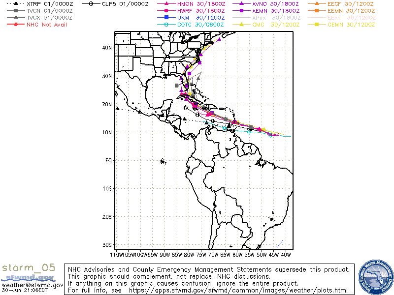
I would like to know what’s going on with the TVCN, very unusual it being such a far outlier from the pack considering it’s a consensus of many models. That sharp zag at the end probably some glitch, but past few runs it’s way R??
0 likes   
Hurricane Eye Experience: David 79, Irene 99, Frances 04, Jeanne 04, Wilma 05... EYE COMING MY WAY IN 2024…
Hurricane Brush Experience: Andrew 92, Erin 95, Floyd 99, Matthew 16, Irma 17, Ian 22, Nicole 22…

User avatar
eastcoastFL
Category 5
Category 5
Posts: 3901
Age: 43
Joined: Thu Apr 12, 2007 12:29 pm
Location: Palm City, FL

Re: ATL: FIVE - Models

#209 Postby eastcoastFL » Wed Jun 30, 2021 8:50 pm

toad strangler wrote:
Cat5James wrote:


... I'd say thats a threat to Florida.


It's potential. A threat is putting up the shutters.
Need a real COC. Until that happens models will swing back & forth significantly.


A threat is a potential. If it were imminent you’d be putting up shutters. When you’re in the cone it becomes a potential threat. When you’re in the 3 day come it’s time to run or hunker down.
3 likes   
Personal Forecast Disclaimer:
The posts in this forum are NOT official forecast and should not be used as such. They are just the opinion of the poster and may or may not be backed by sound meteorological data. They are NOT endorsed by any professional institution or storm2k.org. For official information, please refer to the NHC and NWS products.

User avatar
eastcoastFL
Category 5
Category 5
Posts: 3901
Age: 43
Joined: Thu Apr 12, 2007 12:29 pm
Location: Palm City, FL

Re: ATL: FIVE - Models

#210 Postby eastcoastFL » Wed Jun 30, 2021 8:54 pm

USTropics wrote:
eastcoastFL wrote:
USTropics wrote:The main difference between the GFS and the ECWMF is short-term intensification/organization, which creates substantial track differences. You can see in the 12z ECMWF and 18z GFS run the differences in as little as 48 hours, with the ECMWF showing a weaker system, and thus gets caught in the faster low-level flow and a much quicker forward speed:

ECMWF
https://i.imgur.com/xJNcvqc.png

GFS
https://i.imgur.com/VXgBp34.png

It's not just the operational suite either, as the ECMWF 12z ensemble members are progressively faster (and weaker) than the GFS ensemble members @ 72 hrs:

ECMWF ensembles
https://i.imgur.com/enGYreQ.png

GFS ensembles
https://i.imgur.com/k6yKUFD.png


Can you tell if the Euro initialized in the right location? Also what was the pressure when it initialized?

Looking at weathermodels.com (can't post here because of TOS), they both initialized at the correct latitude, the ECMWF is slightly higher in longitude. Here is the forecasted position from weather.us for 10PM ET:

ECMWF
https://i.imgur.com/uTSc3VM.png

GFS
https://i.imgur.com/qg5ZcEs.png

On a more granular level, ECMWF has a rotating mesovortices rotating to the south:
https://i.imgur.com/tlqMmtG.png


Thank you. I couldn’t on tidbits. They look pretty darn close. That’s what I was trying to find out.
0 likes   
Personal Forecast Disclaimer:
The posts in this forum are NOT official forecast and should not be used as such. They are just the opinion of the poster and may or may not be backed by sound meteorological data. They are NOT endorsed by any professional institution or storm2k.org. For official information, please refer to the NHC and NWS products.

User avatar
eastcoastFL
Category 5
Category 5
Posts: 3901
Age: 43
Joined: Thu Apr 12, 2007 12:29 pm
Location: Palm City, FL

Re: ATL: FIVE - Models

#211 Postby eastcoastFL » Wed Jun 30, 2021 8:55 pm

Blown Away wrote:I would like to know what’s going on with the TVCN, very unusual it being such a far outlier from the pack considering it’s a consensus of many models. That sharp zag at the end probably some glitch, but past few runs it’s way R??


I noticed that too. It’s been making some odd sharp turns. Shouldn’t it be up the middle?
0 likes   
Personal Forecast Disclaimer:
The posts in this forum are NOT official forecast and should not be used as such. They are just the opinion of the poster and may or may not be backed by sound meteorological data. They are NOT endorsed by any professional institution or storm2k.org. For official information, please refer to the NHC and NWS products.

User avatar
SEASON_CANCELED
Category 3
Category 3
Posts: 887
Joined: Mon Jul 06, 2009 5:17 am
Location: 8 Bit Charlie Sheen

Re: ATL: FIVE - Models

#212 Postby SEASON_CANCELED » Wed Jun 30, 2021 8:57 pm

Its just a model. Theres nothing to indicate a florida landfall at all right now, that cone will move as cones always do when its this early

Please do not panic.

I have had enough of the gas runs, toilet paper runs, propane mania, foodapocalyse and everything else the last 2 years have thrown at me living in florida

Please do not panic for god sakes. Wait before we call it
5 likes   
i am a big stupid ugly moron with an ugly face and a big butt and my butt stinks and i like to kiss my own butt

User avatar
eastcoastFL
Category 5
Category 5
Posts: 3901
Age: 43
Joined: Thu Apr 12, 2007 12:29 pm
Location: Palm City, FL

Re: ATL: FIVE - Models

#213 Postby eastcoastFL » Wed Jun 30, 2021 9:00 pm

SEASON_CANCELED wrote:Its just a model. Theres nothing to indicate a florida landfall at all right now, that cone will move as cones always do when its this early

Please do not panic.

I have had enough of the gas runs, toilet paper runs, propane mania, foodapocalyse and everything else the last 2 years have thrown at me living in florida

Please do not panic for god sakes. Wait before we call it


Nobody is panic. It’s a debate over semantics really.
1 likes   
Personal Forecast Disclaimer:
The posts in this forum are NOT official forecast and should not be used as such. They are just the opinion of the poster and may or may not be backed by sound meteorological data. They are NOT endorsed by any professional institution or storm2k.org. For official information, please refer to the NHC and NWS products.

User avatar
toad strangler
S2K Supporter
S2K Supporter
Posts: 4543
Joined: Sun Jul 28, 2013 3:09 pm
Location: Earth
Contact:

Re: ATL: FIVE - Models

#214 Postby toad strangler » Wed Jun 30, 2021 9:11 pm

0 likes   

User avatar
eastcoastFL
Category 5
Category 5
Posts: 3901
Age: 43
Joined: Thu Apr 12, 2007 12:29 pm
Location: Palm City, FL

Re: ATL: FIVE - Models

#215 Postby eastcoastFL » Wed Jun 30, 2021 9:28 pm


I’m still unsure as to why almost every model stays south of the islands except for the euro plowing into to Hispaniola..why?
0 likes   
Personal Forecast Disclaimer:
The posts in this forum are NOT official forecast and should not be used as such. They are just the opinion of the poster and may or may not be backed by sound meteorological data. They are NOT endorsed by any professional institution or storm2k.org. For official information, please refer to the NHC and NWS products.

USTropics
Professional-Met
Professional-Met
Posts: 2649
Joined: Sun Aug 12, 2007 3:45 am
Location: Florida State University

Re: ATL: FIVE - Models

#216 Postby USTropics » Wed Jun 30, 2021 9:44 pm

eastcoastFL wrote:
Blown Away wrote:I would like to know what’s going on with the TVCN, very unusual it being such a far outlier from the pack considering it’s a consensus of many models. That sharp zag at the end probably some glitch, but past few runs it’s way R??


I noticed that too. It’s been making some odd sharp turns. Shouldn’t it be up the middle?


Keep in mind the TVCN is the consensus of the past two runs of the TCON model suite + the ECMWF model. TCON is the consensus of the GUNA model suite + HWRF. GUNA now includes COAMPS and the GFS + interpolated versions of the HMON and UKMET.

Confusing? Add up that flow chart and you get TCON = past two runs of the ECMWF, GFS, UKMETI, COAMPS, HWRF, and HMONI with no corrections to known model bias (I believe only the TVCC has corrections). Best guess is the TVCN has wild swings due to how some of the past two runs of the models (ECWMF, UKMET, and HMON specifically) essentially dissipate the storm over Cuba/Hispaniola (and tracking becomes erratic thereafter).
5 likes   

User avatar
eastcoastFL
Category 5
Category 5
Posts: 3901
Age: 43
Joined: Thu Apr 12, 2007 12:29 pm
Location: Palm City, FL

Re: ATL: FIVE - Models

#217 Postby eastcoastFL » Wed Jun 30, 2021 9:47 pm

USTropics wrote:
eastcoastFL wrote:
Blown Away wrote:I would like to know what’s going on with the TVCN, very unusual it being such a far outlier from the pack considering it’s a consensus of many models. That sharp zag at the end probably some glitch, but past few runs it’s way R??


I noticed that too. It’s been making some odd sharp turns. Shouldn’t it be up the middle?


Keep in mind the TVCN is the consensus of the past two runs of the TCON model suite + the ECMWF model. TCON is the consensus of the GUNA model suite + HWRF. GUNA now includes COAMPS and the GFS + interpolated versions of the HMON and UKMET.

Confusing? Add up that flow chart and you get TCON = past two runs of the ECMWF, GFS, UKMETI, COAMPS, HWRF, and HMONI with no corrections to known model bias (I believe only the TVCC has corrections). Best guess is the TVCN has wild swings due to how some of the past two runs of the models (ECWMF, UKMET, and HMON specifically) essentially dissipate the storm over Cuba/Hispaniola (and tracking becomes erratic thereafter).


That makes sense since the euro is heading further north into Hispaniola then it’s remnants head out to see. That probably causes the TVCN to be a whacky outlier.
0 likes   
Personal Forecast Disclaimer:
The posts in this forum are NOT official forecast and should not be used as such. They are just the opinion of the poster and may or may not be backed by sound meteorological data. They are NOT endorsed by any professional institution or storm2k.org. For official information, please refer to the NHC and NWS products.

USTropics
Professional-Met
Professional-Met
Posts: 2649
Joined: Sun Aug 12, 2007 3:45 am
Location: Florida State University

Re: ATL: FIVE - Models

#218 Postby USTropics » Wed Jun 30, 2021 10:29 pm

For documenting purposes, this was the 12z COAMPS spaghetti plot:

Image

These and similar products can be found here - https://www.nrlmry.navy.mil/coamps-web/web/tc
1 likes   

User avatar
captainbarbossa19
Professional-Met
Professional-Met
Posts: 1092
Age: 27
Joined: Wed Aug 21, 2019 11:09 pm
Location: Beaumont, TX

Re: ATL: FIVE - Models

#219 Postby captainbarbossa19 » Wed Jun 30, 2021 10:59 pm

New GFS is more SW with the storm in the Caribbean.
2 likes   

User avatar
captainbarbossa19
Professional-Met
Professional-Met
Posts: 1092
Age: 27
Joined: Wed Aug 21, 2019 11:09 pm
Location: Beaumont, TX

Re: ATL: FIVE - Models

#220 Postby captainbarbossa19 » Wed Jun 30, 2021 11:06 pm

The GFS is much closer to Jamaica on this run. I wonder if we are about to have more model shifts towards the SW?

Image
0 likes   


Return to “2021”

Who is online

Users browsing this forum: No registered users and 2 guests