ATL: IDA - Remnants - Discussion
Moderator: S2k Moderators
Re: ATL: IDA - Hurricane - Discussion
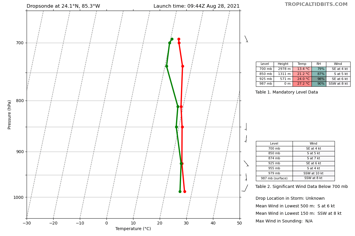
NW side FL and SFMR ~53 kt. Pressure in center around 990.
0 likes
Re: ATL: IDA - Hurricane - Discussion
I thought the pressure would be lower than that, a bit odd
0 likes
Personal Forecast Disclaimer:
The posts in this forum are NOT official forecast and should not be used as such. They are just the opinion of the poster and may or may not be backed by sound meteorological data. They are NOT endorsed by any professional institution or storm2k.org. For official information, please refer to the NHC and NWS products.
The posts in this forum are NOT official forecast and should not be used as such. They are just the opinion of the poster and may or may not be backed by sound meteorological data. They are NOT endorsed by any professional institution or storm2k.org. For official information, please refer to the NHC and NWS products.
-
Shell Mound
- Category 5

- Posts: 2432
- Age: 33
- Joined: Thu Sep 07, 2017 3:39 pm
- Location: St. Petersburg, FL → Scandinavia
Re: ATL: IDA - Hurricane - Discussion
Airboy wrote:I thought the pressure would be lower than that, a bit odd
ML dry air seems to be becoming entrained in the core.
https://twitter.com/MikeFischerWx/status/1431554582845480961
This reminds me of Gustav (2008) and especially Irene (2011): sprawling banding, yet dry air inhibitive.
0 likes
CVW / MiamiensisWx / Shell Mound
The posts in this forum are NOT official forecasts and should not be used as such. They are just the opinion of the poster and may or may not be backed by sound meteorological data. They are NOT endorsed by any professional institution or STORM2K. For official information, please refer to products from the NHC and NWS.


Re: ATL: IDA - Hurricane - Discussion
I’m quite surprised there has been no intensification at all overnight. That should lower its potential landfall intensity…unless it undergoes ERI in the next 24-30 hours.
1 likes
Irene '11 Sandy '12 Hermine '16 5/15/2018 Derecho Fay '20 Isaias '20 Elsa '21 Henri '21 Ida '21
I am only a meteorology enthusiast who knows a decent amount about tropical cyclones. Look to the professional mets, the NHC, or your local weather office for the best information.
I am only a meteorology enthusiast who knows a decent amount about tropical cyclones. Look to the professional mets, the NHC, or your local weather office for the best information.

Re: ATL: IDA - Hurricane - Discussion
986 mb
0 likes
Very useful information on the Dvorak Technique --
https://severe.worldweather.wmo.int/TCF ... kBeven.pdf
https://severe.worldweather.wmo.int/TCF ... kBeven.pdf
Re: ATL: IDA - Hurricane - Discussion
aspen wrote:I’m quite surprised there has been no intensification at all overnight. That should lower its potential landfall intensity…unless it undergoes ERI in the next 24-30 hours.
NE eyewall pass should be more impressive, I bet it's stronger than 70 kts there.
0 likes
Very useful information on the Dvorak Technique --
https://severe.worldweather.wmo.int/TCF ... kBeven.pdf
https://severe.worldweather.wmo.int/TCF ... kBeven.pdf
-
grapealcoholic
- Category 2

- Posts: 703
- Joined: Tue Aug 10, 2021 3:26 pm
Re: ATL: IDA - Hurricane - Discussion
Shell Mound wrote:Airboy wrote:I thought the pressure would be lower than that, a bit odd
ML dry air seems to be becoming entrained in the core.
https://twitter.com/MikeFischerWx/status/1431554582845480961
This reminds me of Gustav (2008) and especially Irene (2011): sprawling banding, yet dry air inhibitive.
Looks to be shedding off those bands as momentum rushes to the core
0 likes
Re: ATL: IDA - Hurricane - Discussion
Airboy wrote:I thought the pressure would be lower than that, a bit odd
With the mesos filling in the eyewall that should help with symmetry it will interesting to see what the AF plane finds in a half hour.
0 likes
-
cycloneye

- Admin

- Posts: 149601
- Age: 69
- Joined: Thu Oct 10, 2002 10:54 am
- Location: San Juan, Puerto Rico
Re: ATL: IDA - Hurricane - Discussion
aspen wrote:I’m quite surprised there has been no intensification at all overnight. That should lower its potential landfall intensity…unless it undergoes ERI in the next 24-30 hours.
Cuba took a toll on it that many here said it would not.
9 likes
Visit the Caribbean-Central America Weather Thread where you can find at first post web cams,radars
and observations from Caribbean basin members Click Here
and observations from Caribbean basin members Click Here
Re: ATL: IDA - Hurricane - Discussion
With the sond showing 986mb it feels more what I thought compare to the around 990 the extrap. showed
0 likes
Personal Forecast Disclaimer:
The posts in this forum are NOT official forecast and should not be used as such. They are just the opinion of the poster and may or may not be backed by sound meteorological data. They are NOT endorsed by any professional institution or storm2k.org. For official information, please refer to the NHC and NWS products.
The posts in this forum are NOT official forecast and should not be used as such. They are just the opinion of the poster and may or may not be backed by sound meteorological data. They are NOT endorsed by any professional institution or storm2k.org. For official information, please refer to the NHC and NWS products.
-
grapealcoholic
- Category 2
- Posts: 703
- Joined: Tue Aug 10, 2021 3:26 pm
Re: ATL: IDA - Hurricane - Discussion
Look how broad the pressure dip is -- that will tighten up soon

0 likes
-
jlauderdal
- S2K Supporter

- Posts: 7240
- Joined: Wed May 19, 2004 5:46 am
- Location: NE Fort Lauderdale
- Contact:
Re: ATL: IDA - Hurricane - Discussion
cycloneye wrote:aspen wrote:I’m quite surprised there has been no intensification at all overnight. That should lower its potential landfall intensity…unless it undergoes ERI in the next 24-30 hours.
Cuba took a toll on it that many here said it would not.
The internal structure of the hurricane continues to be very good and has all the ingredients for RI today, what kind of damage are you seeing from Cuba?
There was a very impressive blow-up of convection as the core hit land. Anyone thinking it was going to come offshore of Cuba and start an immediate intensification process wasn't looking at the forecast or modeling. The best conditions are dead ahead.
4 likes
-
Keldeo1997
- Category 2
- Posts: 688
- Joined: Fri Oct 11, 2019 11:35 pm
Re: ATL: IDA - Hurricane - Discussion
grapealcoholic wrote:Look how broad the pressure dip is -- that will tighten up soon
https://www.tropicaltidbits.com/recon/recon_NOAA3-0809A-IDA_timeseries.png
The main thing Cuba did was flatten out the pressure field. That makes it a larger storm with more momentum needed to get it going. With convection taking off we should see that soon.
0 likes
Re: ATL: IDA - Hurricane - Discussion
Wind field is very large. The structure is better than 24 hours ago, I think Cuba really broadened this sucker out.
0 likes
Very useful information on the Dvorak Technique --
https://severe.worldweather.wmo.int/TCF ... kBeven.pdf
https://severe.worldweather.wmo.int/TCF ... kBeven.pdf
-
alan1961

- Category 2
- Posts: 771
- Joined: Mon Mar 20, 2006 11:58 am
- Location: Derby, Derbyshire, England
- Contact:
Re: ATL: IDA - Hurricane - Discussion
Visioen wrote:How can I go to bed with all these developments.
Btw it's 5 AM here
We get to catch up on the board next day before the US wakes up
1 likes
-
beoumont

- Category 1

- Posts: 473
- Joined: Sun Jul 10, 2011 4:13 pm
- Location: East Central Florida
- Contact:
Re: ATL: IDA - Hurricane - Discussion
Highteeld wrote:Multiple hot towers dancing around each other... extremely foreboding signature. I can't recall a time where a storm didn't explosively deepen after having dual convective towers around the eyewall. I'd expect a cat 2 very soon, if not already.
Is that not a cloud signature of a banded eye structure? (Interlocking bands).
Last edited by beoumont on Sat Aug 28, 2021 6:33 am, edited 1 time in total.
0 likes
List of 79 tropical cyclones intercepted by Richard Horodner:
http://www.canebeard.com/page/page/572246.htm
http://www.canebeard.com/page/page/572246.htm
-
jlauderdal
- S2K Supporter
- Posts: 7240
- Joined: Wed May 19, 2004 5:46 am
- Location: NE Fort Lauderdale
- Contact:
Re: ATL: IDA - Hurricane - Discussion
xironman wrote:grapealcoholic wrote:Look how broad the pressure dip is -- that will tighten up soon
https://www.tropicaltidbits.com/recon/recon_NOAA3-0809A-IDA_timeseries.png
The main thing Cuba did was flatten out the pressure field. That makes it a larger storm with more momentum needed to get it going. With convection taking off we should see that soon.
Exactly, western Cuba has rarely had much real effect on a developed tropical system, now that weak sauce ragged tropical stuff we see suffers but IDA certainly wasn't that as it came onshore yesterday afternoon. This system has a real shot at 5, predicting 5's is risky business, they are rare and legendary, fortunately. I give this one a 30% chance but regardless of a 3,4,5, NO is in a very difficult position, who wakes up and says hey I want to evacuate because it's so much fun. However, NO is a wobble or two away from a major hurricane and regardless of the wobble, it's the surge. Surge is far more dangerous than wind so if you are in an evac zone, keep it simple and evac.
If you have never seen surge, do a search on Youtube.
6 likes
-
Shell Mound
- Category 5
- Posts: 2432
- Age: 33
- Joined: Thu Sep 07, 2017 3:39 pm
- Location: St. Petersburg, FL → Scandinavia
Re: ATL: IDA - Hurricane - Discussion
Highteeld wrote:Wind field is very large. The structure is better than 24 hours ago, I think Cuba really broadened this sucker out.
Actually the size is average at best per advisories.
2 likes
CVW / MiamiensisWx / Shell Mound
The posts in this forum are NOT official forecasts and should not be used as such. They are just the opinion of the poster and may or may not be backed by sound meteorological data. They are NOT endorsed by any professional institution or STORM2K. For official information, please refer to products from the NHC and NWS.
Who is online
Users browsing this forum: No registered users and 10 guests