ATL: SAM - Remnants - Discussion
Moderator: S2k Moderators
-
ElectricStorm

- Category 5

- Posts: 5148
- Age: 25
- Joined: Tue Aug 13, 2019 11:23 pm
- Location: Norman, OK
Re: ATL: INVEST 98L - Discussion Update= 18z Best Track upgrades to TD 18
Looks like it's just about there to me. I'm thinking they upgrade at the 4pm advisory. 10pm at the latest
1 likes
B.S Meteorology, University of Oklahoma '25
Please refer to the NHC, NWS, or SPC for official information.
Please refer to the NHC, NWS, or SPC for official information.
-
grapealcoholic
- Category 2

- Posts: 703
- Joined: Tue Aug 10, 2021 3:26 pm
Re: ATL: INVEST 98L - Discussion
Weather Dude wrote:Looks like it's just about there to me. I'm thinking they upgrade at the 4pm advisory. 10pm at the latest
I agree. TD is likely at 4pm, not sure if it has TS winds yet
0 likes
-
Hurrilurker

- Category 2
- Posts: 738
- Joined: Mon Jun 09, 2003 3:32 pm
- Location: San Francisco, CA
Re: ATL: INVEST 98L - Discussion
grapealcoholic wrote:Weather Dude wrote:Looks like it's just about there to me. I'm thinking they upgrade at the 4pm advisory. 10pm at the latest
I agree. TD is likely at 4pm, not sure if it has TS winds yet
I've seen TS that look a lot worse, this thing has fully-wrapped spin (if not perfect stacking yet) with excellent outflow.
4 likes
-
SconnieCane
- Category 5
- Posts: 1013
- Joined: Thu Aug 02, 2018 5:29 pm
- Location: Madison, WI
Re: ATL: INVEST 98L - Discussion
Hurrilurker wrote:grapealcoholic wrote:Weather Dude wrote:Looks like it's just about there to me. I'm thinking they upgrade at the 4pm advisory. 10pm at the latest
I agree. TD is likely at 4pm, not sure if it has TS winds yet
I've seen TS that look a lot worse, this thing has fully-wrapped spin (if not perfect stacking yet) with excellent outflow.
Three of them over the last week, to be exact. This one should finally buck the trend of systems looking better before classification than after.
5 likes
-
gatorcane

- S2K Supporter

- Posts: 23708
- Age: 48
- Joined: Sun Mar 13, 2005 3:54 pm
- Location: Boca Raton, FL
Re: ATL: INVEST 98L - Discussion
Looks to be well on its way, could get a designation by 5pm EST from NHC:
6 likes
-
ouragans

- Category 2
- Posts: 501
- Age: 54
- Joined: Sun Jun 12, 2011 12:09 pm
- Location: Abymes, Guadeloupe F.W.I
- Contact:
Re: ATL: INVEST 98L - Discussion
aspen wrote:The 2pm TWO will probably use the “if these trends continue, advisories will be initiated later this afternoon/evening” wording. It’s so close now that I bet it gets designated at 5pm.
I do too. TD at 5PM
0 likes
Personal forecast disclaimer
This post is a personal point of view, not an information. Please refer to official statements for life-threatening decisions.
David '79, Frederic '79, Hugo '89, Iris, Luis & Marilyn '95, Georges '98, Lenny '99, Dean '07, Irma '17, Maria '17, Fiona '22, Philippe '23, Tammy '23
16°13'33.3,"6N -61°36'39.5"W
Re: ATL: INVEST 98L - Discussion
abajan wrote:https://youtu.be/0mm1Q7ADoe8
After watching this update...it's sensible for those residing in the Caribbean...and the Southeast CONUS to pay attention to future "Sam"....
0 likes

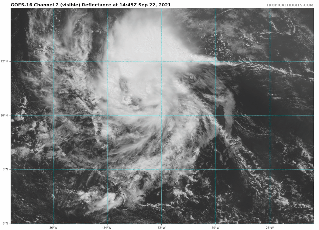
Re: ATL: INVEST 98L - Discussion
gatorcane wrote:Looks to be well on its way, could get a designation by 5pm EST from NHC:
https://i.postimg.cc/1XygDkMg/goes16-vis-98-L-202109221445.gif
It still has that “umbilical cord” on its east side that it first had last night.
Also, since 98L is developing a full day earlier than most of the models have forecast up until this point, the HWRF’s solutions of a major on Saturday seem quite possible.
0 likes
Irene '11 Sandy '12 Hermine '16 5/15/2018 Derecho Fay '20 Isaias '20 Elsa '21 Henri '21 Ida '21
I am only a meteorology enthusiast who knows a decent amount about tropical cyclones. Look to the professional mets, the NHC, or your local weather office for the best information.
I am only a meteorology enthusiast who knows a decent amount about tropical cyclones. Look to the professional mets, the NHC, or your local weather office for the best information.
-
galaxy401

- Category 5
- Posts: 2446
- Age: 30
- Joined: Sat Aug 25, 2012 9:04 pm
- Location: Casa Grande, Arizona
Re: ATL: INVEST 98L - Discussion
aspen wrote:The 2pm TWO will probably use the “if these trends continue, advisories will be initiated later this afternoon/evening” wording. It’s so close now that I bet it gets designated at 5pm.
The 2pm Outlook appears to just be a copy-and-paste from the previous one...
0 likes
Got my eyes on moving right into Hurricane Alley: Florida.
-
crownweather

- S2K Supporter
- Posts: 602
- Age: 51
- Joined: Sat Aug 12, 2006 9:21 am
- Location: Sturbridge, Massachusetts
- Contact:
Re: ATL: INVEST 98L - Discussion
TD at 5 pm?? Maybe....
Showers and thunderstorms remain well organized in association with
a tropical wave located several hundred miles southwest of the Cabo
Verde Islands. In addition, recent satellite wind data indicates
that the circulation is gradually becoming better defined. If these
trends continue, a tropical depression could form as soon as this
afternoon or evening. This system should move westward at 10 to 15
mph across the eastern and central tropical Atlantic Ocean.
Additional information on this system, including gale warnings, can
be found in High Seas Forecasts issued by the National Weather
Service.
* Formation chance through 48 hours...high...near 100 percent.
* Formation chance through 5 days...high...near 100 percent.
1 likes
Rob Lightbown
Crown Weather Services
https://crownweather.com
Crown Weather Services
https://crownweather.com
Re: ATL: INVEST 98L - Discussion
galaxy401 wrote:aspen wrote:The 2pm TWO will probably use the “if these trends continue, advisories will be initiated later this afternoon/evening” wording. It’s so close now that I bet it gets designated at 5pm.
The 2pm Outlook appears to just be a copy-and-paste from the previous one...
No, they included this:
“ If these
trends continue, a tropical depression could form as soon as this
afternoon or evening.”
We’ll probably have TD18 at 5pm
2 likes
Irene '11 Sandy '12 Hermine '16 5/15/2018 Derecho Fay '20 Isaias '20 Elsa '21 Henri '21 Ida '21
I am only a meteorology enthusiast who knows a decent amount about tropical cyclones. Look to the professional mets, the NHC, or your local weather office for the best information.
I am only a meteorology enthusiast who knows a decent amount about tropical cyclones. Look to the professional mets, the NHC, or your local weather office for the best information.
-
Iceresistance

- Category 5
- Posts: 9598
- Age: 22
- Joined: Sat Oct 10, 2020 9:45 am
- Location: Tecumseh, OK/Norman, OK
Re: ATL: INVEST 98L - Discussion
crownweather wrote:TD at 5 pm?? Maybe....Showers and thunderstorms remain well organized in association with
a tropical wave located several hundred miles southwest of the Cabo
Verde Islands. In addition, recent satellite wind data indicates
that the circulation is gradually becoming better defined. If these
trends continue, a tropical depression could form as soon as this
afternoon or evening. This system should move westward at 10 to 15
mph across the eastern and central tropical Atlantic Ocean.
Additional information on this system, including gale warnings, can
be found in High Seas Forecasts issued by the National Weather
Service.
* Formation chance through 48 hours...high...near 100 percent.
* Formation chance through 5 days...high...near 100 percent.
Does anyone recall a Non-PTC system that had a near 100% chance of development before?
0 likes
Bill 2015 & Beta 2020
Winter 2020-2021
All observations are in Tecumseh, OK unless otherwise noted.
Winter posts are focused mainly for Oklahoma & Texas.
Take any of my forecasts with a grain of salt, refer to the NWS, SPC, and NHC for official information
Never say Never with weather! Because ANYTHING is possible!
Winter 2020-2021
All observations are in Tecumseh, OK unless otherwise noted.
Winter posts are focused mainly for Oklahoma & Texas.
Take any of my forecasts with a grain of salt, refer to the NWS, SPC, and NHC for official information
Never say Never with weather! Because ANYTHING is possible!
-
supercane4867
- Category 5
- Posts: 4966
- Joined: Wed Nov 14, 2012 10:43 am
Re: ATL: INVEST 98L - Discussion
Iceresistance wrote:crownweather wrote:TD at 5 pm?? Maybe....Showers and thunderstorms remain well organized in association with
a tropical wave located several hundred miles southwest of the Cabo
Verde Islands. In addition, recent satellite wind data indicates
that the circulation is gradually becoming better defined. If these
trends continue, a tropical depression could form as soon as this
afternoon or evening. This system should move westward at 10 to 15
mph across the eastern and central tropical Atlantic Ocean.
Additional information on this system, including gale warnings, can
be found in High Seas Forecasts issued by the National Weather
Service.
* Formation chance through 48 hours...high...near 100 percent.
* Formation chance through 5 days...high...near 100 percent.
Does anyone recall a Non-PTC system that had a near 100% chance of development before?
It happens frequently prior to the beginning of PTC designation
6 likes
-
SconnieCane
- Category 5
- Posts: 1013
- Joined: Thu Aug 02, 2018 5:29 pm
- Location: Madison, WI
Re: ATL: INVEST 98L - Discussion
Iceresistance wrote:crownweather wrote:TD at 5 pm?? Maybe....Showers and thunderstorms remain well organized in association with
a tropical wave located several hundred miles southwest of the Cabo
Verde Islands. In addition, recent satellite wind data indicates
that the circulation is gradually becoming better defined. If these
trends continue, a tropical depression could form as soon as this
afternoon or evening. This system should move westward at 10 to 15
mph across the eastern and central tropical Atlantic Ocean.
Additional information on this system, including gale warnings, can
be found in High Seas Forecasts issued by the National Weather
Service.
* Formation chance through 48 hours...high...near 100 percent.
* Formation chance through 5 days...high...near 100 percent.
Does anyone recall a Non-PTC system that had a near 100% chance of development before?
PTC advisories are only used if proximity to land is such that TS watches/warnings need to be issued before tropical cyclogenesis actually occurs.
0 likes
-
Shell Mound
- Category 5
- Posts: 2432
- Age: 33
- Joined: Thu Sep 07, 2017 3:39 pm
- Location: St. Petersburg, FL → Scandinavia
Re: ATL: INVEST 98L - Discussion
An intriguing tidbit: since 1851 twenty-three hurricanes have passed within 60 n mi of Bermuda during the month of October. Here is the decadal breakdown:
Based on the data at hand, the past decade was the most active for Bermuda during the month of October since the last decade of the nineteenth century.
- 1851–60: 2
- 1861–70: 2
- 1871–80: 1
- 1881–90: 2
- 1891–00: 4
- 1901–10: 1
- 1911–20: 0
- 1921–30: 1
- 1931–40: 1
- 1941–50: 2
- 1951–60: 0
- 1961–70: 1
- 1971–80: 0
- 1981–90: 0
- 1991–00: 1
- 2001–10: 1
- 2011–20: 4
Based on the data at hand, the past decade was the most active for Bermuda during the month of October since the last decade of the nineteenth century.
0 likes
CVW / MiamiensisWx / Shell Mound
The posts in this forum are NOT official forecasts and should not be used as such. They are just the opinion of the poster and may or may not be backed by sound meteorological data. They are NOT endorsed by any professional institution or STORM2K. For official information, please refer to products from the NHC and NWS.
-
Sciencerocks
- Category 5
- Posts: 10186
- Age: 40
- Joined: Thu Jul 06, 2017 1:51 am

-
wxman57

- Moderator-Pro Met

- Posts: 23175
- Age: 68
- Joined: Sat Jun 21, 2003 8:06 pm
- Location: Houston, TX (southwest)
Re: ATL: INVEST 98L - Discussion
Certainly appears to be more of a TD than Peter or Rose. Expect an NHC upgrade shortly. Big upper low/trough over the East U.S. Coast next week should turn it well east of the U.S. Possibly a Newfoundland threat in 12 days or so. Can't rule out any threat to Nova Scotia, I suppose.
2 likes
-
AlphaToOmega
- Category 5
- Posts: 1448
- Joined: Sat Jun 26, 2021 10:51 am
- Location: Somewhere in Massachusetts
Re: ATL: EIGHTEEN - Tropical Depression
AL, 98, 2021092218, , BEST, 0, 101N, 332W, 30, 1008, TD, 34, NEQ, 0, 0, 0, 0, 1012, 120, 40, 40, 0, L, 0, , 0, 0, INVEST, S, 0, , 0, 0, 0, 0, genesis-num, 038,
There it is: Tropical Depression 18L
7 likes

Re: ATL: INVEST 98L - Discussion Update= Best Track upgrades to TD 18
AL182021 - Tropical Depression EIGHTEEN
https://rammb-data.cira.colostate.edu/tc_realtime/season.asp?storm_season=2021
1 likes
Who is online
Users browsing this forum: No registered users and 18 guests