CPAC: LINDA - Post-Tropical

Moderator: S2k Moderators

Message
Author
User avatar
Kingarabian
S2K Supporter
S2K Supporter
Posts: 15979
Joined: Sat Aug 08, 2009 3:06 am
Location: Honolulu, Hawaii

Re: EPAC: LINDA - Hurricane

#141 Postby Kingarabian » Fri Aug 13, 2021 4:21 am

Two hour old GMI pass
Still a little dry and ragged at this mid levels but ominous and well defined cyan ring:
Image
Image
0 likes   
RIP Kobe Bryant

User avatar
Kingarabian
S2K Supporter
S2K Supporter
Posts: 15979
Joined: Sat Aug 08, 2009 3:06 am
Location: Honolulu, Hawaii

Re: EPAC: LINDA - Hurricane

#142 Postby Kingarabian » Fri Aug 13, 2021 4:34 am

UW - CIMSS
ADVANCED DVORAK TECHNIQUE
ADT-Version 9.0
Tropical Cyclone Intensity Algorithm

----- Current Analysis -----
Date : 13 AUG 2021 Time : 083035 UTC
Lat : 16:17:59 N Lon : 110:31:11 W


CI# /Pressure/ Vmax
4.7 / 974.9mb/ 82.2kt


Final T# Adj T# Raw T#
4.7 5.2 5.7

Estimated radius of max. wind based on IR : 10 km

Center Temp : -1.1C Cloud Region Temp : -63.1C

Scene Type : EYE

Subtropical Adjustment : OFF

Extratropical Adjustment : OFF

Positioning Method : ARCHER POSITIONING

Ocean Basin : EAST PACIFIC
Dvorak CI > MSLP Conversion Used : CKZ Method

Tno/CI Rules : Constraint Limits : MW AdjEnd
Weakening Flag : OFF
Rapid Dissipation Flag : OFF
0 likes   
RIP Kobe Bryant

User avatar
Yellow Evan
Professional-Met
Professional-Met
Posts: 16143
Age: 27
Joined: Fri Jul 15, 2011 12:48 pm
Location: Henderson, Nevada/Honolulu, HI
Contact:

Re: EPAC: LINDA - Hurricane

#143 Postby Yellow Evan » Fri Aug 13, 2021 4:58 am

Assuming the eye can sustain itself, Linda should reach Category 2 status at the next package, and Category 3 by this afternoon or evening.
0 likes   

User avatar
Yellow Evan
Professional-Met
Professional-Met
Posts: 16143
Age: 27
Joined: Fri Jul 15, 2011 12:48 pm
Location: Henderson, Nevada/Honolulu, HI
Contact:

Re: EPAC: LINDA - Hurricane

#144 Postby Yellow Evan » Fri Aug 13, 2021 5:11 am

Image

T4.5 until the DG junk goes away. OW eye surrounded by LG embedded in MG.
0 likes   

User avatar
Yellow Evan
Professional-Met
Professional-Met
Posts: 16143
Age: 27
Joined: Fri Jul 15, 2011 12:48 pm
Location: Henderson, Nevada/Honolulu, HI
Contact:

Re: EPAC: LINDA - Hurricane

#145 Postby Yellow Evan » Fri Aug 13, 2021 5:39 am

Seems clearing eye attempt #4 has failed though each attempt has been more successful than its last.
1 likes   

Shell Mound
Category 5
Category 5
Posts: 2434
Age: 32
Joined: Thu Sep 07, 2017 3:39 pm
Location: St. Petersburg, FL → Scandinavia

Re: EPAC: LINDA - Hurricane

#146 Postby Shell Mound » Fri Aug 13, 2021 7:04 am

Warmer SST to its west notwithstanding, given persistent northerly shear, Linda seems unlikely to become much stronger than 80 kt. The eye remains obscured.
0 likes   
CVW / MiamiensisWx / Shell Mound
The posts in this forum are NOT official forecasts and should not be used as such. They are just the opinion of the poster and may or may not be backed by sound meteorological data. They are NOT endorsed by any professional institution or STORM2K. For official information, please refer to products from the NHC and NWS.

User avatar
aspen
Category 5
Category 5
Posts: 8818
Joined: Sat Oct 12, 2019 7:10 pm
Location: Connecticut, USA

Re: EPAC: LINDA - Hurricane

#147 Postby aspen » Fri Aug 13, 2021 7:37 am

Eye clearing attempt number…I lost count lol. Maybe Linda will finally find some luck with intensification.
0 likes   
Irene '11 Sandy '12 Hermine '16 5/15/2018 Derecho Fay '20 Isaias '20 Elsa '21 Henri '21 Ida '21

I am only a meteorology enthusiast who knows a decent amount about tropical cyclones. Look to the professional mets, the NHC, or your local weather office for the best information.

Subtrop
Category 2
Category 2
Posts: 670
Joined: Sun Feb 21, 2021 9:45 pm

Re: EPAC: LINDA - Hurricane

#148 Postby Subtrop » Fri Aug 13, 2021 8:38 am

EP, 12, 2021081312, , BEST, 0, 166N, 1112W, 90, 971, HU,
0 likes   

User avatar
Yellow Evan
Professional-Met
Professional-Met
Posts: 16143
Age: 27
Joined: Fri Jul 15, 2011 12:48 pm
Location: Henderson, Nevada/Honolulu, HI
Contact:

Re: EPAC: LINDA - Hurricane

#149 Postby Yellow Evan » Fri Aug 13, 2021 9:04 am

TXPZ23 KNES 131204
TCSENP

A. 12E (LINDA)

B. 13/1130Z

C. 16.6N

D. 111.1W

E. ONE/GOES-W

F. T4.5/4.5

G. IR/EIR/SWIR

H. REMARKS...SYSTEM HAS A DARK GRAY EYE THAT IS SURROUNDED BY A LG RING
TEMP AND IS EMBEDDED IN MG RESULTING TO AN EYE PATTERN DT OF 4.5. THE
24 HR DEVELOPING TREND RESULTS IN DEVELOPING RAPIDLY. MET IS 5.0 AND PT
IS 4.5. FT IS BASED ON DT.

I. ADDL POSITIONS

NIL


...PATEL
0 likes   

User avatar
Yellow Evan
Professional-Met
Professional-Met
Posts: 16143
Age: 27
Joined: Fri Jul 15, 2011 12:48 pm
Location: Henderson, Nevada/Honolulu, HI
Contact:

Re: EPAC: LINDA - Hurricane

#150 Postby Yellow Evan » Fri Aug 13, 2021 9:21 am

* GFS version *
* EAST PACIFIC 2021 SHIPS INTENSITY FORECAST *
* IR SAT DATA AVAILABLE, OHC AVAILABLE *
* LINDA EP122021 08/13/21 12 UTC *

TIME (HR) 0 6 12 18 24 36 48 60 72 84 96 108 120 132 144 156 168
V (KT) NO LAND 90 93 94 93 94 89 85 82 81 79 77 75 71 67 62 56 49
V (KT) LAND 90 93 94 93 94 89 85 82 81 79 77 75 71 67 62 56 49
V (KT) LGEM 90 93 94 94 92 87 80 74 68 63 60 59 56 50 43 36 30
Storm Type TROP TROP TROP TROP TROP TROP TROP TROP TROP TROP TROP TROP TROP TROP TROP TROP TROP

SHEAR (KT) 15 13 8 6 6 6 5 6 6 6 2 4 3 2 5 6 4
SHEAR ADJ (KT) 1 0 1 2 0 3 2 0 -3 -4 0 1 1 6 3 4 4
SHEAR DIR 21 24 21 11 20 76 92 16 26 52 342 35 321 108 165 138 214
SST (C) 27.6 27.4 27.8 28.2 28.5 26.9 26.6 26.3 25.1 25.3 26.0 26.0 25.5 24.1 23.5 22.8 23.2
POT. INT. (KT) 141 139 143 147 150 133 129 126 114 116 123 123 119 104 98 91 96
200 MB T (C) -53.4 -53.4 -53.0 -53.2 -53.2 -52.7 -52.9 -52.6 -52.9 -52.5 -52.9 -52.3 -52.5 -52.5 -52.7 -52.5 -52.3
200 MB VXT (C) 0.2 0.6 0.7 0.7 0.5 0.4 0.6 0.6 0.8 0.5 0.6 0.5 0.8 0.5 0.6 0.5 0.3
TH_E DEV (C) 5 5 6 6 6 5 4 4 4 4 3 4 3 2 2 1 1
700-500 MB RH 78 76 75 71 71 66 63 57 56 53 53 49 47 43 42 37 31
MODEL VTX (KT) 23 25 25 24 26 25 26 26 27 28 27 27 26 23 20 15 11
850 MB ENV VOR -16 -15 -16 -24 -18 -10 -2 2 21 35 53 60 67 58 55 45 48
200 MB DIV 39 57 40 32 16 20 -19 3 -18 6 -19 -13 -32 0 -3 -1 -9
700-850 TADV -16 -8 -1 1 0 4 6 1 2 2 0 0 0 0 0 2 4
LAND (KM) 711 693 704 743 799 903 1046 1218 1419 1581 1734 1881 2060 2139 1955 1738 1494
LAT (DEG N) 16.6 17.1 17.6 18.0 18.3 18.8 18.9 18.7 18.4 18.1 17.8 17.9 18.3 xx.x xx.x xx.x xx.x
LONG(DEG W) 111.2 112.5 113.7 114.8 115.9 118.2 120.2 122.1 124.4 126.3 128.0 129.9 132.3 xxx.x xxx.x xxx.x xxx.x
STM SPEED (KT) 12 13 12 11 11 10 9 10 11 9 9 10 11 10 11 13 14
HEAT CONTENT 8 7 8 10 11 4 2 1 0 0 0 0 0 0 0 0 0

FORECAST TRACK FROM OFCI INITIAL HEADING/SPEED (DEG/KT):300/ 11 CX,CY: -9/ 6
T-12 MAX WIND: 75 PRESSURE OF STEERING LEVEL (MB): 577 (MEAN=587)
GOES IR BRIGHTNESS TEMP. STD DEV. 50-200 KM RAD: 11.5 (MEAN=14.5)
% GOES IR PIXELS WITH T < -20 C 50-200 KM RAD: 87.0 (MEAN=65.0)
PRELIM RI PROB (DV .GE. 35 KT IN 36 HR): 4.4

INDIVIDUAL CONTRIBUTIONS TO INTENSITY CHANGE
6 12 18 24 36 48 60 72 84 96 108 120 132 144 156 168
------------------------------------------------------------------------------
SAMPLE MEAN CHANGE 0. 0. 1. 1. 1. 2. 1. 1. 0. -0. -1. -2. -2. -3. -4. -4.
SST POTENTIAL -0. 0. 0. 0. -3. -9. -14. -20. -24. -28. -30. -32. -35. -38. -43. -48.
VERTICAL SHEAR MAG -1. -2. -2. -2. -1. 1. 3. 5. 7. 8. 9. 10. 10. 11. 11. 12.
VERTICAL SHEAR ADJ -0. -0. -0. -0. -1. -1. -1. -0. 0. 0. 0. 0. -0. -0. -0. -0.
VERTICAL SHEAR DIR 0. 0. 0. 0. 0. 0. 0. 0. 0. 0. 0. -0. -1. -1. -1. -1.
PERSISTENCE 4. 5. 5. 5. 3. 2. 0. -1. -1. -1. -1. -2. -2. -2. -1. -1.
200/250 MB TEMP. 0. 0. -0. -0. 0. 0. 1. 2. 2. 3. 3. 4. 4. 5. 5. 5.
THETA_E EXCESS -0. -0. -0. -0. -1. -2. -2. -3. -4. -4. -5. -5. -6. -6. -8. -10.
700-500 MB RH 0. 0. 0. 0. 1. 1. 0. 0. 0. 0. 0. -0. -0. -1. -1. -2.
MODEL VTX TENDENCY 1. 1. 1. 2. 1. 3. 4. 6. 6. 5. 5. 3. -0. -4. -7. -10.
850 MB ENV VORTICITY -0. -0. -0. -0. -0. 0. 0. 1. 1. 1. 1. 0. 0. 0. 0. 0.
200 MB DIVERGENCE 0. 0. 0. -0. -0. -1. -1. -2. -3. -3. -3. -3. -2. -1. 0. 1.
850-700 T ADVEC 0. 0. 0. 0. 0. 0. 0. 0. 0. 0. 0. 0. 0. 0. 0. 1.
ZONAL STORM MOTION 0. 0. 0. 0. 1. 1. 1. 1. 1. 0. 0. 0. 0. 0. 0. -0.
STEERING LEVEL PRES -0. -0. -0. -0. -0. 0. 0. 0. 0. 0. 0. 0. -0. -0. -0. -0.
DAYS FROM CLIM. PEAK 0. 0. 0. 0. 0. 0. 1. 1. 1. 2. 2. 2. 3. 3. 3. 4.
GOES PREDICTORS -0. -0. -1. -1. -0. 1. 1. 1. 1. 1. 2. 1. 2. 2. 2. 3.
OCEAN HEAT CONTENT -0. -0. -0. -0. -0. -1. -1. -1. -0. -0. 0. 1. 2. 2. 4. 6.
RI POTENTIAL -0. -1. -1. -2. -3. -3. -2. -1. 1. 2. 3. 3. 3. 3. 3. 3.
------------------------------------------------------------------------------
TOTAL CHANGE 3. 4. 3. 4. -1. -5. -8. -9. -11. -13. -15. -19. -23. -28. -34. -40.

CURRENT MAX WIND (KT): 90. LAT, LON: 16.6 111.2

** 2021 E. Pacific RI INDEX EP122021 LINDA 08/13/21 12 UTC **
(SHIPS-RII PREDICTOR TABLE for 30 KT OR MORE MAXIMUM WIND INCREASE IN NEXT 24-h)

Predictor Value RI Predictor Range Scaled Value(0-1) % Contribution
POT = MPI-VMAX (KT) : 54.0 40.5 to 149.3 0.12 0.9
12 HR PERSISTENCE (KT) : 15.0 -22.0 to 44.0 0.56 4.7
D200 (10**7s-1) : 36.8 -33.0 to 159.5 0.36 2.5
850-200 MB SHEAR (KT) : 9.5 19.6 to 1.3 0.55 3.6
MAXIMUM WIND (KT) : 90.0 22.5 to 132.0 0.57 2.9
STD DEV OF IR BR TEMP : 11.5 37.8 to 2.1 0.74 3.4
BL DRY-AIR FLUX (W/M2) : 272.8 800.8 to -82.5 0.60 -3.1
HEAT CONTENT (KJ/CM2) : 8.8 2.7 to 106.7 0.06 0.2
%area of TPW <45 mm upshear : 0.0 56.6 to 0.0 1.00 1.4
2nd PC OF IR BR TEMP : 0.7 2.2 to -2.3 0.33 0.3

SHIPS Prob RI for 20kt/ 12hr RI threshold= 12% is 1.9 times climatological mean ( 6.3%)
SHIPS Prob RI for 25kt/ 24hr RI threshold= 18% is 1.4 times climatological mean (12.5%)
SHIPS Prob RI for 30kt/ 24hr RI threshold= 17% is 2.0 times climatological mean ( 8.6%)
SHIPS Prob RI for 35kt/ 24hr RI threshold= 16% is 2.6 times climatological mean ( 6.2%)
SHIPS Prob RI for 40kt/ 24hr RI threshold= 10% is 2.4 times climatological mean ( 4.2%)
SHIPS Prob RI for 45kt/ 36hr RI threshold= 12% is 1.8 times climatological mean ( 6.7%)
SHIPS Prob RI for 55kt/ 48hr RI threshold= 0% is 0.0 times climatological mean ( 5.9%)
SHIPS Prob RI for 65kt/ 72hr RI threshold= 0% is 0.0 times climatological mean ( 4.7%)

Matrix of RI probabilities
------------------------------------------------------------------------------
RI (kt / h) | 20/12 | 25/24 | 30/24 | 35/24 | 40/24 | 45/36 | 55/48 |65/72
------------------------------------------------------------------------------
SHIPS-RII: 11.7% 18.0% 16.8% 15.9% 10.1% 12.3% 0.0% 0.0%
Logistic: 3.8% 6.7% 3.1% 2.0% 0.7% 1.4% 0.5% 0.1%
Bayesian: 0.7% 2.1% 0.3% 0.1% 0.1% 0.0% 0.0% 0.0%
Consensus: 5.4% 8.9% 6.8% 6.0% 3.6% 4.6% 0.2% 0.0%
DTOPS: 999.0% 999.0% 999.0% 999.0% 999.0% 999.0% 999.0% 999.0%

## ANNULAR HURRICANE INDEX (AHI) EP122021 LINDA 08/13/21 12 UTC ##
## STORM NOT ANNULAR, SCREENING STEP FAILED, NPASS=5 NFAIL=2 ##
## AHI= 0 (AHI OF 100 IS BEST FIT TO ANN. STRUC., 1 IS MARGINAL, 0 IS NOT ANNULAR) ##
0 likes   

User avatar
Yellow Evan
Professional-Met
Professional-Met
Posts: 16143
Age: 27
Joined: Fri Jul 15, 2011 12:48 pm
Location: Henderson, Nevada/Honolulu, HI
Contact:

Re: EPAC: LINDA - Hurricane

#151 Postby Yellow Evan » Fri Aug 13, 2021 10:47 am

000
WTPZ42 KNHC 131444
TCDEP2

Hurricane Linda Discussion Number 14
NWS National Hurricane Center Miami FL EP122021
900 AM MDT Fri Aug 13 2021

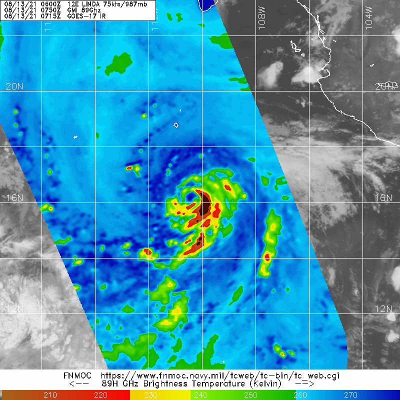
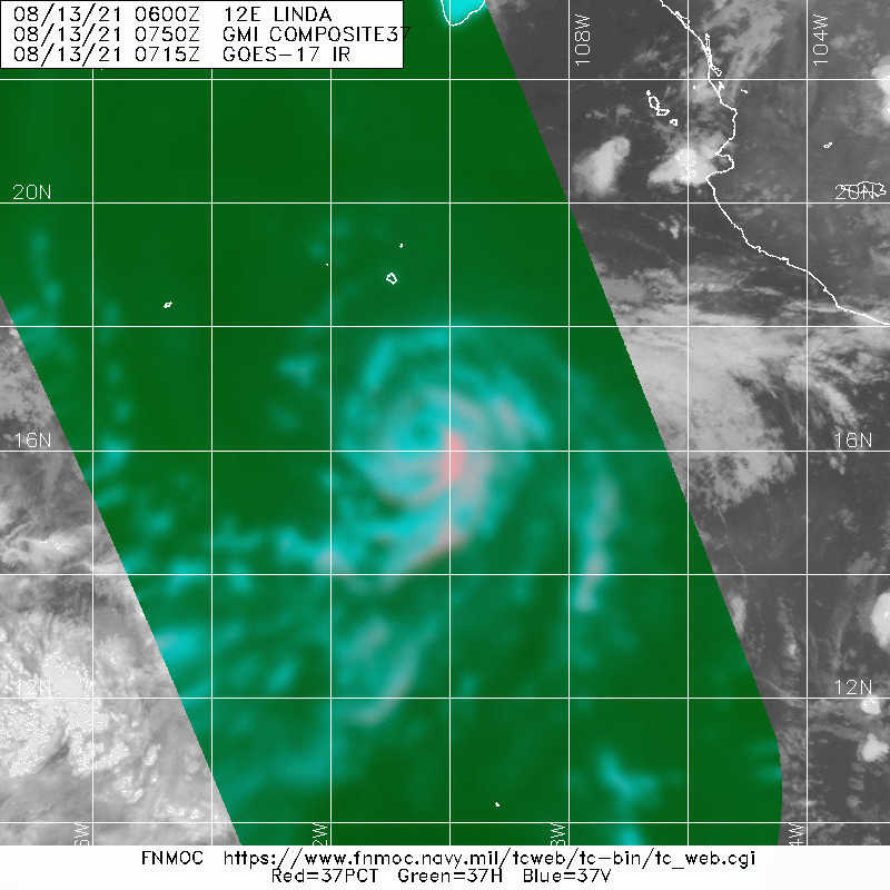
Linda's structure has continued to improve since early this morning.
An eye was evident in longwave and shortwave IR imagery from GOES-17
and GOES-15 near 1200 UTC, though it has since become obscured by
cold cloud tops associated with eyewall convection. An earlier AMSR
overpass showed evidence of a ring of shallow to moderate
convection, often associated with rapidly intensifying cyclones.
Intensity estimates at 1200 UTC ranged from 77 kt to 97 kt, so the
initial intensity was set at 90 kt, in closest agreement with the
U-W CIMSS SATCON. It is worth noting that Linda's intensity is in a
range where estimates can range greatly, so confidence in that
assessment is not particularly high.

Computational problems with the GFS this morning has limited the
guidance available for the forecast, particularly with respect to
the intensity. Therefore, despite the higher initial intensity and
recent improvement in convective structure, the official intensity
forecast was only modestly increased in the short term. It does not
appear that wind shear will be a major inhibiting factor during the
next day or two. Environmental moisture and SSTs should also be
sufficient for further strengthening. The NHC forecast is a little
above the model consensus and previous forecast for the next
24-36 h. After that time, Linda should move over cooler SSTs which
should cause at least gradual weakening. By the end of the 5-day
period, the NHC forecast is in line with the consensus and identical
to the previous advisory.

Only small tweaks were made to the NHC track forecast. Linda
continues to move toward the west-northwest with an estimated
forward speed of 11 kt. The global models unanimously forecast that
a deep-layer ridge to the north of Linda will build over the
weekend, causing the hurricane to turn westward, and then
west-southwestward by early next week. Confidence in the track
forecast is quite high due to the agreement among the track models.

FORECAST POSITIONS AND MAX WINDS

INIT 13/1500Z 16.9N 111.8W 90 KT 105 MPH
12H 14/0000Z 17.6N 113.6W 100 KT 115 MPH
24H 14/1200Z 18.4N 115.9W 105 KT 120 MPH
36H 15/0000Z 18.8N 118.2W 105 KT 120 MPH
48H 15/1200Z 18.8N 120.3W 100 KT 115 MPH
60H 16/0000Z 18.6N 122.3W 90 KT 105 MPH
72H 16/1200Z 18.2N 124.2W 80 KT 90 MPH
96H 17/1200Z 17.5N 128.0W 65 KT 75 MPH
120H 18/1200Z 18.5N 132.0W 60 KT 70 MPH

$$
Forecaster Zelinsky
0 likes   

User avatar
Yellow Evan
Professional-Met
Professional-Met
Posts: 16143
Age: 27
Joined: Fri Jul 15, 2011 12:48 pm
Location: Henderson, Nevada/Honolulu, HI
Contact:

Re: EPAC: LINDA - Hurricane

#152 Postby Yellow Evan » Fri Aug 13, 2021 10:48 am

Image

Still battling dry air but CDO trying to smooth out. Should be a major before too long.
0 likes   

Sciencerocks
Category 5
Category 5
Posts: 9154
Age: 39
Joined: Thu Jul 06, 2017 1:51 am

Re: EPAC: LINDA - Hurricane

#153 Postby Sciencerocks » Fri Aug 13, 2021 11:40 am

Image
1 likes   

User avatar
Yellow Evan
Professional-Met
Professional-Met
Posts: 16143
Age: 27
Joined: Fri Jul 15, 2011 12:48 pm
Location: Henderson, Nevada/Honolulu, HI
Contact:

Re: EPAC: LINDA - Hurricane

#154 Postby Yellow Evan » Fri Aug 13, 2021 11:48 am

Image

Would explain the recent deepening.
3 likes   

psyclone
S2K Supporter
S2K Supporter
Posts: 4762
Joined: Wed Aug 24, 2005 9:04 pm
Location: palm harbor fl

Re: EPAC: LINDA - Hurricane

#155 Postby psyclone » Fri Aug 13, 2021 11:49 am

I like to pop in to the EPAC on occasion to see what a real storm looks like. Linda is impressive today
4 likes   

User avatar
Yellow Evan
Professional-Met
Professional-Met
Posts: 16143
Age: 27
Joined: Fri Jul 15, 2011 12:48 pm
Location: Henderson, Nevada/Honolulu, HI
Contact:

Re: EPAC: LINDA - Hurricane

#156 Postby Yellow Evan » Fri Aug 13, 2021 11:49 am

----- Current Analysis -----
Date : 13 AUG 2021 Time : 155032 UTC
Lat : 17:00:00 N Lon : 111:45:36 W


CI# /Pressure/ Vmax
5.5 / 959.1mb/102.0kt


Final T# Adj T# Raw T#
5.5 5.6 5.6

Estimated radius of max. wind based on IR : 14 km

Center Temp : +2.9C Cloud Region Temp : -61.4C

Scene Type : EYE
0 likes   

User avatar
Yellow Evan
Professional-Met
Professional-Met
Posts: 16143
Age: 27
Joined: Fri Jul 15, 2011 12:48 pm
Location: Henderson, Nevada/Honolulu, HI
Contact:

Re: EPAC: LINDA - Hurricane

#157 Postby Yellow Evan » Fri Aug 13, 2021 12:53 pm

Image

Still struggling to mix out dry air at times which seems to be allowing for only gradual intensification.
0 likes   

dexterlabio
Category 5
Category 5
Posts: 3468
Joined: Sat Oct 24, 2009 11:50 pm

Re: EPAC: LINDA - Hurricane

#158 Postby dexterlabio » Fri Aug 13, 2021 1:03 pm

Linda was almost written off as another bust but she made it. :lol:
0 likes   
Personal Forecast Disclaimer:
The posts in this forum are NOT official forecast and should not be used as such. They are just the opinion of the poster and may or may not be backed by sound meteorological data. They are NOT endorsed by any professional institution or storm2k.org. For official information, please refer to the NHC and NWS products.

User avatar
Kingarabian
S2K Supporter
S2K Supporter
Posts: 15979
Joined: Sat Aug 08, 2009 3:06 am
Location: Honolulu, Hawaii

Re: EPAC: LINDA - Hurricane

#159 Postby Kingarabian » Fri Aug 13, 2021 1:26 pm

SAB up to 5.5/5.5. Should be enough for a major since ADT is at 5.5 as well.
0 likes   
RIP Kobe Bryant

User avatar
Yellow Evan
Professional-Met
Professional-Met
Posts: 16143
Age: 27
Joined: Fri Jul 15, 2011 12:48 pm
Location: Henderson, Nevada/Honolulu, HI
Contact:

Re: EPAC: LINDA - Hurricane

#160 Postby Yellow Evan » Fri Aug 13, 2021 1:27 pm

TXPZ23 KNES 131800
TCSENP

A. 12E (LINDA)

B. 13/1730Z

C. 17.1N

D. 112.1W

E. ONE/GOES-W

F. T5.5/5.5

G. IR/EIR/VIS/SSMIS

H. REMARKS...SYSTEM HAS A WMG EYE TEMP SURROUNDED BY LG RING TEMP AND
IS EMBEDDED IN LG RESULTING IN AN EYE PATTERN DT OF 5.5. ADDITIONALLY,
SYSTEM HAS A DISTINCT COMMA LIKE SHAPE IN EIR IMAGERY. THE 24 HR
DEVELOPING TREND RESULTS IN DEVELOPING RAPIDLY. MET IS 5.5 AND PT IS
5.0. FT IS BASED ON DT.

I. ADDL POSITIONS

13/1203Z 16.6N 111.2W SSMIS


...PATEL


Too high. Embedded in MG not LG.
0 likes   


Return to “2021”

Who is online

Users browsing this forum: No registered users and 2 guests