ATL: FRED - Post-Tropical - Discussion

Moderator: S2k Moderators

Message
Author
User avatar
AtlanticWind
S2K Supporter
S2K Supporter
Posts: 1887
Age: 66
Joined: Sun Aug 08, 2004 9:57 pm
Location: Plantation,Fla

Re: ATL: INVEST 94L - Discussion

#141 Postby AtlanticWind » Sun Aug 08, 2021 9:04 pm

Aric Dunn wrote:updated ASCAT. besides some ambiguities from being on the edge... it is pretty clear the llc is consolidated around 12N near or likely now under this current burst.

https://i.ibb.co/Tm446FQ/Capture.png

Not looking great, I am starting think this stays weak until interacting with Hispanola
and ending any chance.
0 likes   

User avatar
SFLcane
S2K Supporter
S2K Supporter
Posts: 10163
Age: 47
Joined: Sat Jun 05, 2010 1:44 pm
Location: Lake Worth Florida

Re: ATL: INVEST 94L - Discussion

#142 Postby SFLcane » Sun Aug 08, 2021 9:09 pm

Aric Dunn wrote:Here is the previous ASCAT with Ambiguities removed showing less elongation... this also compares the euro model ( the green arrows) to observed..

models will be adjusting come 6z.

https://i.ibb.co/7YMZrKN/Capture.png


They already are with a complete island tour. :layout:
0 likes   

User avatar
toad strangler
S2K Supporter
S2K Supporter
Posts: 4543
Joined: Sun Jul 28, 2013 3:09 pm
Location: Earth
Contact:

Re: ATL: INVEST 94L - Discussion

#143 Postby toad strangler » Sun Aug 08, 2021 9:13 pm

SFLcane wrote:
Aric Dunn wrote:Here is the previous ASCAT with Ambiguities removed showing less elongation... this also compares the euro model ( the green arrows) to observed..

models will be adjusting come 6z.

https://i.ibb.co/7YMZrKN/Capture.png


They already are with a complete island tour. :layout:


You know better than that. Running the spine of the GA's from SSE to WNW is way too fine of a track this far out. Any subtlety can put a center N or S of everything.
7 likes   

User avatar
SFLcane
S2K Supporter
S2K Supporter
Posts: 10163
Age: 47
Joined: Sat Jun 05, 2010 1:44 pm
Location: Lake Worth Florida

Re: ATL: INVEST 94L - Discussion

#144 Postby SFLcane » Sun Aug 08, 2021 9:16 pm

toad strangler wrote:
SFLcane wrote:
Aric Dunn wrote:Here is the previous ASCAT with Ambiguities removed showing less elongation... this also compares the euro model ( the green arrows) to observed..

models will be adjusting come 6z.

https://i.ibb.co/7YMZrKN/Capture.png


They already are with a complete island tour. :layout:


You know better than that. Running the spine of the GA's from SSE to WNW is way too fine of a track this far out. Any subtlety can put a center N or S of everything.


I know I am just bored! Lol..

But just not overly impressed yet and these wanna monsoon crapola invest are really starting to annoy me. :red:
3 likes   

sma10
Category 5
Category 5
Posts: 1710
Joined: Tue Aug 02, 2005 1:13 pm

Re: ATL: INVEST 94L - Discussion

#145 Postby sma10 » Sun Aug 08, 2021 9:16 pm

AtlanticWind wrote:
Aric Dunn wrote:updated ASCAT. besides some ambiguities from being on the edge... it is pretty clear the llc is consolidated around 12N near or likely now under this current burst.

https://i.ibb.co/Tm446FQ/Capture.png

Not looking great, I am starting think this stays weak until interacting with Hispanola
and ending any chance.


Possibly. But way too early, at least 3 days before it would be approaching Hispaniola
2 likes   

User avatar
AtlanticWind
S2K Supporter
S2K Supporter
Posts: 1887
Age: 66
Joined: Sun Aug 08, 2004 9:57 pm
Location: Plantation,Fla

Re: ATL: INVEST 94L - Discussion

#146 Postby AtlanticWind » Sun Aug 08, 2021 9:19 pm

SFLcane wrote:
toad strangler wrote:
SFLcane wrote:
They already are with a complete island tour. :layout:


You know better than that. Running the spine of the GA's from SSE to WNW is way too fine of a track this far out. Any subtlety can put a center N or S of everything.


I know I am just bored! Lol..

But just not overly impressed yet and these wanna monsoon crapola invest are really starting to annoy me. :red:

Me too, watching it too closely today,
A lot could change in next few days.
0 likes   

User avatar
Spacecoast
Category 2
Category 2
Posts: 758
Joined: Thu Aug 31, 2017 2:03 pm

Re: ATL: INVEST 94L - Discussion

#147 Postby Spacecoast » Sun Aug 08, 2021 9:25 pm

Aric Dunn wrote:updated ASCAT. besides some ambiguities from being on the edge... it is pretty clear the llc is consolidated around 12N near or likely now under this current burst.

https://i.ibb.co/Tm446FQ/Capture.png


AMSU Microwave 89 GHz Imagery (4 km Mercator)
As of 21:55..
Image
1 likes   

User avatar
Woofde
Category 1
Category 1
Posts: 479
Joined: Tue Jul 06, 2021 11:33 am

Re: ATL: INVEST 94L - Discussion

#148 Postby Woofde » Sun Aug 08, 2021 9:32 pm

Don't count this out as getting island shredded yet. This storm has trended west and south quite a bit. If it continues south of predicted it could miss the major island shredders and cruise through the Carribean. It would only need to go 50-75 miles south of where the models currently predict. We are talking about a track still 3 to 5 days away that's not very much and is a realistic possibility. If this slight southern deviation did happen the future of this will be quite different.

Sent from my SM-G988U1 using Tapatalk
3 likes   

User avatar
Hurricaneman
Category 5
Category 5
Posts: 7351
Age: 45
Joined: Tue Aug 31, 2004 3:24 pm
Location: central florida

Re: ATL: INVEST 94L - Discussion

#149 Postby Hurricaneman » Sun Aug 08, 2021 9:38 pm

Jamaica needs to monitor the progress of 94L as it seems to be consolidating south of where the models have it and it’s not gaining latitude as quickly either
4 likes   

User avatar
Stormybajan
Category 1
Category 1
Posts: 448
Joined: Thu May 20, 2021 3:21 pm
Location: Windward Islands

Re: ATL: INVEST 94L - Discussion

#150 Postby Stormybajan » Sun Aug 08, 2021 9:46 pm

Hurricaneman wrote:Jamaica needs to monitor the progress of 94L as it seems to be consolidating south of where the models have it and it’s not gaining latitude as quickly either

I agree, although it looks like it wont do much east of the lesser antilies ( maybe a bit of rain?) if it keeps to the south and the caribbean has low shear I think there maybe a chance it can form into Fred somewhere south of PR or DR
0 likes   
Sad West Indies and Manchester United fan ⚽️

User avatar
Hurricaneman
Category 5
Category 5
Posts: 7351
Age: 45
Joined: Tue Aug 31, 2004 3:24 pm
Location: central florida

Re: ATL: INVEST 94L - Discussion

#151 Postby Hurricaneman » Sun Aug 08, 2021 9:52 pm

Also my track is actually similar to Charley in 2004 but 50kts is my max for this with a landfall between Ft Myers and Cedar Key next week but that can change
0 likes   

User avatar
AnnularCane
S2K Supporter
S2K Supporter
Posts: 2860
Joined: Thu Jun 08, 2006 9:18 am
Location: Wytheville, VA

Re: ATL: INVEST 94L - Discussion

#152 Postby AnnularCane » Sun Aug 08, 2021 10:11 pm

SFLcane wrote:
toad strangler wrote:
SFLcane wrote:
They already are with a complete island tour. :layout:


You know better than that. Running the spine of the GA's from SSE to WNW is way too fine of a track this far out. Any subtlety can put a center N or S of everything.


I know I am just bored! Lol..

But just not overly impressed yet and these wanna monsoon crapola invest are really starting to annoy me. :red:


If nothing else, think of it as a sign of things to come. Hey, it's the most we've had since Elsa!
5 likes   
"But it never rained rain. It never snowed snow. And it never blew just wind. It rained things like soup and juice. It snowed mashed potatoes and green peas. And sometimes the wind blew in storms of hamburgers." -- Judi Barrett, Cloudy with a Chance of Meatballs

User avatar
chaser1
S2K Supporter
S2K Supporter
Posts: 5464
Age: 64
Joined: Sat Oct 15, 2005 5:59 pm
Location: Longwood, Fl

Re: ATL: INVEST 94L - Discussion

#153 Postby chaser1 » Sun Aug 08, 2021 11:19 pm

toad strangler wrote:
SFLcane wrote:
Aric Dunn wrote:Here is the previous ASCAT with Ambiguities removed showing less elongation... this also compares the euro model ( the green arrows) to observed..

models will be adjusting come 6z.

https://i.ibb.co/7YMZrKN/Capture.png


They already are with a complete island tour. :layout:


You know better than that. Running the spine of the GA's from SSE to WNW is way too fine of a track this far out. Any subtlety can put a center N or S of everything.


Absolutely! In fact, Elsa was a great example of that. I knew then and stated several times since, Elsa's general track will be a harbinger of things to come. Right now the models are playing "pin the tail on the donkey". Once they get a decent handle on any increasingly deeper and better organized LLC, we could well be looking at a starkly different scenario. I'm not suggesting 94L will mirror Elsa's track - no two disturbances are exactly alike. Forward motion being the most obvious first distinction that comes to mind. And, by the way.... take a gander at the GFS 18Z 200-800 wind-sheer forecast for 0Z Friday. If we were to have our 2nd TS thus far this year deepening while still traversing through the Eastern Caribbean, present wind shear forecasts suggest a quite favorable upper air pattern "if" a COC were to still be south of the Greater Antilles. I think a potential outcome of us having a minimal hurricane between days 4-5 somewhere south of Western Haiti, the Windward Passage, or Eastern Cuba as a very real possibility. Maybe a track across Hispaniola will disrupt it first. Or maybe, a 10 knot forward speed over warm SST's, along with very favorable upper air might present E. Cuba with a threat greater then Elsa presented.
2 likes   
Andy D

(For official information, please refer to the NHC and NWS products.)

User avatar
ElectricStorm
Category 5
Category 5
Posts: 5043
Age: 24
Joined: Tue Aug 13, 2019 11:23 pm
Location: Skiatook, OK / Norman, OK

Re: ATL: INVEST 94L - Discussion

#154 Postby ElectricStorm » Mon Aug 09, 2021 12:33 am

2AM EDT
1. A low pressure system located about 380 miles east-southeast of the
Leeward Islands is producing disorganized showers and thunderstorms.
Environmental conditions are expected to be conducive for some
development over the next few days, and a tropical depression could
form while the low moves west-northwestward at about 15 mph. The
disturbance is forecast to reach portions of the Lesser Antilles by
late tonight, then move near the Virgin Islands and Puerto Rico on
Tuesday, and be near Hispaniola around the middle of this week.
Tropical storm watches or warnings could be required with
shorter-than-normal lead times for portions of the Leeward Islands,
the Virgin Islands, and Puerto Rico. In addition, heavy rains and
flooding are likely for the Leeward Islands, Virgin Islands, and
Puerto Rico. Interests in those areas should monitor the progress
of this system.
* Formation chance through 48 hours...medium...50 percent.
* Formation chance through 5 days...medium...60 percent.
0 likes   
B.S Meteorology, University of Oklahoma '25

Please refer to the NHC, NWS, or SPC for official information.

Aric Dunn
Category 5
Category 5
Posts: 21238
Age: 42
Joined: Sun Sep 19, 2004 9:58 pm
Location: Ready for the Chase.
Contact:

Re: ATL: INVEST 94L - Discussion

#155 Postby Aric Dunn » Mon Aug 09, 2021 3:08 am

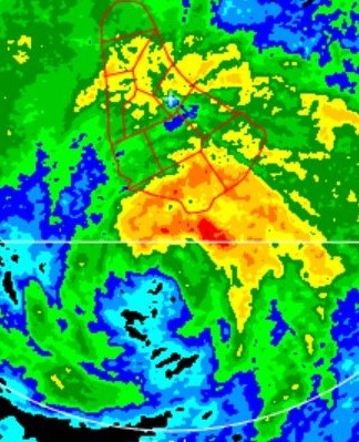
Deep convection wrapping around now. Center is still right around 12n. Right aboit where the souther convection is building north. Yoh can see towers moving south and north..

It is not up in that big blob.

Radar also showing the cell movement. Llc us E/ese of barbados still.
4 likes   
Note: If I make a post that is brief. Please refer back to previous posts for the analysis or reasoning. I do not re-write/qoute what my initial post said each time.
If there is nothing before... then just ask :)

Space & Atmospheric Physicist, Embry-Riddle Aeronautical University,
I believe the sky is falling...

SconnieCane
Category 4
Category 4
Posts: 998
Joined: Thu Aug 02, 2018 5:29 pm
Location: Madison, WI

Re: ATL: INVEST 94L - Discussion

#156 Postby SconnieCane » Mon Aug 09, 2021 3:55 am

SFLcane wrote:
Aric Dunn wrote:Here is the previous ASCAT with Ambiguities removed showing less elongation... this also compares the euro model ( the green arrows) to observed..

models will be adjusting come 6z.

https://i.ibb.co/7YMZrKN/Capture.png


They already are with a complete island tour. :layout:


Isaias and Laura would have something to say about that...
0 likes   

xironman
S2K Supporter
S2K Supporter
Posts: 2522
Joined: Sun Jun 10, 2007 4:53 pm
Location: NoVA

Re: ATL: INVEST 94L - Discussion

#157 Postby xironman » Mon Aug 09, 2021 4:01 am

Looks like it might race west, not much of a northerly component.

Image
3 likes   

User avatar
ouragans
Category 1
Category 1
Posts: 490
Age: 53
Joined: Sun Jun 12, 2011 12:09 pm
Location: Abymes, Guadeloupe F.W.I
Contact:

Re: ATL: INVEST 94L - Discussion

#158 Postby ouragans » Mon Aug 09, 2021 4:03 am

Invest 94L
As of 06:00 UTC Aug 09, 2021:

Location: 12.8°N 56.2°W
Maximum Winds: 25 kt Gusts: N/A
Minimum Central Pressure: 1010 mb
Environmental Pressure: N/A
Radius of Circulation: N/A
Radius of Maximum wind: 60 nm
0 likes   
Personal forecast disclaimer
This post is a personal point of view, not an information. Please refer to official statements for life-threatening decisions.

David '79, Frederic '79, Hugo '89, Iris, Luis & Marilyn '95, Georges '98, Lenny '99, Dean '07, Irma '17, Maria '17, Fiona '22, Philippe '23, Tammy '23
16°13'33.3,"6N -61°36'39.5"W

User avatar
AtlanticWind
S2K Supporter
S2K Supporter
Posts: 1887
Age: 66
Joined: Sun Aug 08, 2004 9:57 pm
Location: Plantation,Fla

Re: ATL: INVEST 94L - Discussion

#159 Postby AtlanticWind » Mon Aug 09, 2021 4:10 am

Aric Dunn wrote:Deep convection wrapping around now. Center is still right around 12n. Right aboit where the souther convection is building north. Yoh can see towers moving south and north..

It is not up in that big blob.

Radar also showing the cell movement. Llc us E/ese of barbados still.

If thats where the llc is its in bad shape convection wise , also a weak system in the southeast
carribean rarely survives
1 likes   

User avatar
AtlanticWind
S2K Supporter
S2K Supporter
Posts: 1887
Age: 66
Joined: Sun Aug 08, 2004 9:57 pm
Location: Plantation,Fla

Re: ATL: INVEST 94L - Discussion

#160 Postby AtlanticWind » Mon Aug 09, 2021 4:24 am

I think the llc will end up more to the north later today due to reformations.
1 likes   


Return to “2021”

Who is online

Users browsing this forum: No registered users and 1 guest