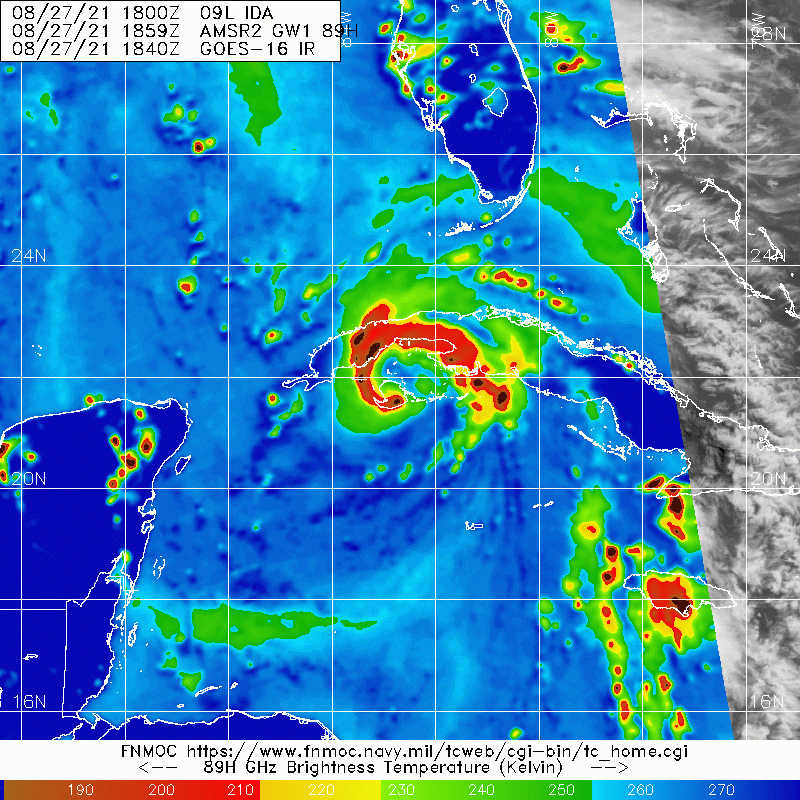
ATL: IDA - Remnants - Discussion

Moderator: S2k Moderators

Message
Author
User avatar
Hypercane_Kyle
Category 5
Category 5
Posts: 3352
Joined: Sat Mar 07, 2015 7:58 pm
Location: Cape Canaveral, FL

Re: ATL: IDA - Hurricane - Discussion

#1321 Postby Hypercane_Kyle » Fri Aug 27, 2021 3:09 pm

supercane4867 wrote:
AlabamaDave wrote:
supercane4867 wrote:The fate of Ida becoming a top tier major hurricane in the Gulf is determined by the passage of Cuba. There will certainly be some degree of structural disruption since the system has already developed an inner core.


How good is western Cuba at disrupting a hurricane core? Even at the widest point, it's 45 miles across with elevations maxing out around 1,600 feet (as far as I can tell from terrain maps).

Depends on various factors including the system's forward speed and intensity at the time of landfall. Gustav crossed the western tip of Cuba and never recovered but many storms crossing at high-end TS to low-end hurricane strength recovered pretty quickly without issues. My guess is that it won't cause that much of a disruption to Ida but it's hard to tell with the current inner core being relatively small.


There were a few other factors that prevented Gustav from redeveloping an inner core, such as shear and dry air. Even though Ida has a decent inner core right now, it won't get disrupted nearly as bad as Cat 4 Gustav was.
1 likes   
My posts are my own personal opinion, defer to the National Hurricane Center (NHC) and other NOAA products for decision making during hurricane season.

User avatar
aspen
Category 5
Category 5
Posts: 8818
Joined: Sat Oct 12, 2019 7:10 pm
Location: Connecticut, USA

Re: ATL: IDA - Hurricane - Discussion

#1322 Postby aspen » Fri Aug 27, 2021 3:10 pm


That’s gonna be a big eye once it’s in the Gulf of Mexico.

Ida seems to be nearing landfall, and will probably be over land before the next recon plane is able to get to it.
0 likes   
Irene '11 Sandy '12 Hermine '16 5/15/2018 Derecho Fay '20 Isaias '20 Elsa '21 Henri '21 Ida '21

I am only a meteorology enthusiast who knows a decent amount about tropical cyclones. Look to the professional mets, the NHC, or your local weather office for the best information.

FormerNewtotex
Tropical Low
Tropical Low
Posts: 27
Joined: Tue Mar 16, 2021 11:41 am

Re: ATL: IDA - Hurricane - Discussion

#1323 Postby FormerNewtotex » Fri Aug 27, 2021 3:14 pm

bella_may wrote:
FormerNewtotex wrote:
Hurrilurker wrote:It looks to me like it's not so much the Isle of Youth that's disrupting it, but the inflow over the mountains to the north on the Cuba mainland. In any case, I expect it to reorganize very quickly after it comes off the coast.


Will the interaction with land over mainland Cuba have any effect on the track?

If the center reforms then yes


With the way things are currently with Ida does it seem like it will happen?
Or, does it appear to stick to the NHC track? It doesn't look like Cuba is mountainous enough to completely disrupt the center like Hispaniola or something would, I'm I reading that right?
0 likes   
Old account "Newtotex"
Most memorable tornadoes: 1997 & 2000 Tuscaloosa Tornadoes, 1998 Oak Grove Tornado
Hurricane Opal/Ivan/Katrina

Shell Mound
Category 5
Category 5
Posts: 2434
Age: 32
Joined: Thu Sep 07, 2017 3:39 pm
Location: St. Petersburg, FL → Scandinavia

Re: ATL: IDA - Hurricane - Discussion

#1324 Postby Shell Mound » Fri Aug 27, 2021 3:14 pm

One possible bit of good news: Ida’s wind field currently appears to be much more compact than modelled previously, given that earlier model runs showed a much larger radius of ≥ 34-kt (tropical-storm-/gale-force) MSW by this time. This might indicate higher background pressures that could persist until landfall on Louisiana. A smaller system would tend to produce significant surge over a narrower swath of the coastline, so in that sense Ida’s structural evolution may prove fortuitous. However, even a small but intense Ida would produce substantial surge near its eye, and the projected angle of approach still favours severe surge, in addition to heavy rainfall and potentially catastrophic winds.
1 likes   
CVW / MiamiensisWx / Shell Mound
The posts in this forum are NOT official forecasts and should not be used as such. They are just the opinion of the poster and may or may not be backed by sound meteorological data. They are NOT endorsed by any professional institution or STORM2K. For official information, please refer to products from the NHC and NWS.

User avatar
skyline385
Category 5
Category 5
Posts: 2728
Age: 35
Joined: Wed Aug 26, 2020 11:15 pm
Location: Houston TX

Re: ATL: IDA - Hurricane - Discussion

#1325 Postby skyline385 » Fri Aug 27, 2021 3:16 pm

Shell Mound wrote:One possible bit of good news: Ida’s wind field currently appears to be much more compact than modelled previously, given that earlier model runs showed a much larger radius of ≥ 34-kt (tropical-storm-/gale-force) MSW by this time. This might indicate higher background pressures that could persist until landfall on Louisiana. A smaller system would tend to produce significant surge over a narrower swath of the coastline, so in that sense Ida’s structural evolution may prove fortuitous. However, even a small but intense Ida would produce substantial surge near its eye, and the projected angle of approach still favours severe surge, in addition to heavy rainfall and potentially catastrophic winds.

Both hurricane models are suggesting an EWRC before landfall though
2 likes   

CrazyC83
Professional-Met
Professional-Met
Posts: 34002
Joined: Tue Mar 07, 2006 11:57 pm
Location: Deep South, for the first time!

Re: ATL: IDA - Hurricane - Discussion

#1326 Postby CrazyC83 » Fri Aug 27, 2021 3:16 pm

Hurricanes often have a way of "stair stepping". That seems to be likely what is happening, not a hard turn to the west. The land interaction may have adjusted its course too.
3 likes   

User avatar
cheezyWXguy
Category 5
Category 5
Posts: 6108
Joined: Mon Feb 13, 2006 12:29 am
Location: Dallas, TX

Re: ATL: IDA - Hurricane - Discussion

#1327 Postby cheezyWXguy » Fri Aug 27, 2021 3:17 pm

Hypercane_Kyle wrote:
supercane4867 wrote:
AlabamaDave wrote:
How good is western Cuba at disrupting a hurricane core? Even at the widest point, it's 45 miles across with elevations maxing out around 1,600 feet (as far as I can tell from terrain maps).

Depends on various factors including the system's forward speed and intensity at the time of landfall. Gustav crossed the western tip of Cuba and never recovered but many storms crossing at high-end TS to low-end hurricane strength recovered pretty quickly without issues. My guess is that it won't cause that much of a disruption to Ida but it's hard to tell with the current inner core being relatively small.


There were a few other factors that prevented Gustav from redeveloping an inner core, such as shear and dry air. Even though Ida has a decent inner core right now, it won't get disrupted nearly as bad as Cat 4 Gustav was.

Yeah, Gustav had a structure south of Cuba that allowed it to manage 155mph winds in the face of 20kt of shear, but landfall on Cuba opened the door for that shear and dry air to reach the core. Ida is strong, but nowhere near as well developed as gustav was in this location, and the environment is a lot less hostile this time around. This is probably more akin to charley’s crossing.
4 likes   

User avatar
Highteeld
Category 5
Category 5
Posts: 2139
Age: 41
Joined: Tue Jan 30, 2018 9:10 pm
Location: Chicago

Re: ATL: IDA - Hurricane - Discussion

#1328 Postby Highteeld » Fri Aug 27, 2021 3:18 pm

Immediately seeing new Hot Towers now the center of the storm is back over water. This bodes very poorly for the United States.
4 likes   
Very useful information on the Dvorak Technique --

https://severe.worldweather.wmo.int/TCF ... kBeven.pdf

User avatar
FLpanhandle91
Category 5
Category 5
Posts: 1033
Age: 34
Joined: Mon Sep 13, 2010 3:50 pm
Location: Fort Walton Beach, FL

Re: ATL: IDA - Hurricane - Discussion

#1329 Postby FLpanhandle91 » Fri Aug 27, 2021 3:19 pm

Shell Mound wrote:
FLpanhandle91 wrote:Ida appears to have made landfall in Cuba near Playa Dayaniguas.

Don’t you mean La Demajagua on the Isle of Youth? Radar indicates that the eye is still over the northern edge of the Isle of Youth.


You are correct. I mistook a banding feature on IR for the eyewall. Apologies.
2 likes   

tomatkins
Tropical Storm
Tropical Storm
Posts: 222
Joined: Wed Sep 05, 2018 2:11 pm

Re: ATL: IDA - Hurricane - Discussion

#1330 Postby tomatkins » Fri Aug 27, 2021 3:20 pm

Hypercane_Kyle wrote:
supercane4867 wrote:
AlabamaDave wrote:
How good is western Cuba at disrupting a hurricane core? Even at the widest point, it's 45 miles across with elevations maxing out around 1,600 feet (as far as I can tell from terrain maps).

Depends on various factors including the system's forward speed and intensity at the time of landfall. Gustav crossed the western tip of Cuba and never recovered but many storms crossing at high-end TS to low-end hurricane strength recovered pretty quickly without issues. My guess is that it won't cause that much of a disruption to Ida but it's hard to tell with the current inner core being relatively small.


There were a few other factors that prevented Gustav from redeveloping an inner core, such as shear and dry air. Even though Ida has a decent inner core right now, it won't get disrupted nearly as bad as Cat 4 Gustav was.


I feel like low end storms just dont have as much to disrupt. A Cat 4 is a well oiled machine and throwing a wrench in the works by crossing over land messes that machine up. But a Cat 1 is not all that well organized - they seem to recover quicker because their simply isnt as big of a drop from their base state to the disrupted state.
6 likes   

Shell Mound
Category 5
Category 5
Posts: 2434
Age: 32
Joined: Thu Sep 07, 2017 3:39 pm
Location: St. Petersburg, FL → Scandinavia

Re: ATL: IDA - Hurricane - Discussion

#1331 Postby Shell Mound » Fri Aug 27, 2021 3:21 pm

0 likes   
CVW / MiamiensisWx / Shell Mound
The posts in this forum are NOT official forecasts and should not be used as such. They are just the opinion of the poster and may or may not be backed by sound meteorological data. They are NOT endorsed by any professional institution or STORM2K. For official information, please refer to products from the NHC and NWS.

User avatar
FLpanhandle91
Category 5
Category 5
Posts: 1033
Age: 34
Joined: Mon Sep 13, 2010 3:50 pm
Location: Fort Walton Beach, FL

Re: ATL: IDA - Hurricane - Discussion

#1332 Postby FLpanhandle91 » Fri Aug 27, 2021 3:21 pm

Kermit in the air.
5 likes   

grapealcoholic
Category 2
Category 2
Posts: 684
Joined: Tue Aug 10, 2021 3:26 pm

Re: ATL: IDA - Hurricane - Discussion

#1333 Postby grapealcoholic » Fri Aug 27, 2021 3:21 pm

Shell Mound wrote:One possible bit of good news: Ida’s wind field currently appears to be much more compact than modelled previously, given that earlier model runs showed a much larger radius of ≥ 34-kt (tropical-storm-/gale-force) MSW by this time. This might indicate higher background pressures that could persist until landfall on Louisiana. A smaller system would tend to produce significant surge over a narrower swath of the coastline, so in that sense Ida’s structural evolution may prove fortuitous. However, even a small but intense Ida would produce substantial surge near its eye, and the projected angle of approach still favours severe surge, in addition to heavy rainfall and potentially catastrophic winds.

Just wait till it gets into the gulf and wraps that feeder band
1 likes   

User avatar
ConvergenceZone
Category 5
Category 5
Posts: 5194
Joined: Fri Jul 29, 2005 1:40 am
Location: Northern California

Re: ATL: IDA - Hurricane - Discussion

#1334 Postby ConvergenceZone » Fri Aug 27, 2021 3:22 pm

Shell Mound wrote:One possible bit of good news: Ida’s wind field currently appears to be much more compact than modelled previously, given that earlier model runs showed a much larger radius of ≥ 34-kt (tropical-storm-/gale-force) MSW by this time. This might indicate higher background pressures that could persist until landfall on Louisiana. A smaller system would tend to produce significant surge over a narrower swath of the coastline, so in that sense Ida’s structural evolution may prove fortuitous. However, even a small but intense Ida would produce substantial surge near its eye, and the projected angle of approach still favours severe surge, in addition to heavy rainfall and potentially catastrophic winds.


While it won't have time for 2 Eyewall Replacement Cycles, it should have time for 1, and that alone will expand the windfield.... So how it looks now has no bearing on how it's going to look once it hits land.....
1 likes   

ChrisH-UK
Category 2
Category 2
Posts: 625
Joined: Sat May 29, 2021 8:22 am

Re: ATL: IDA - Hurricane - Discussion

#1335 Postby ChrisH-UK » Fri Aug 27, 2021 3:23 pm

A view of IDA from GOES-16 combining Visible Green Band and CIRA Optical Depth ona 1 hour loop. The view helps to show the structure inside IDA by looking at the density of the clouds.

Source - https://col.st/FR6Jt

4 likes   

grapealcoholic
Category 2
Category 2
Posts: 684
Joined: Tue Aug 10, 2021 3:26 pm

Re: ATL: IDA - Hurricane - Discussion

#1336 Postby grapealcoholic » Fri Aug 27, 2021 3:23 pm

The eye is west of the southwest tip of the Isle of Youth. Look at cloud movement on IR
1 likes   

ChrisH-UK
Category 2
Category 2
Posts: 625
Joined: Sat May 29, 2021 8:22 am

Re: ATL: IDA - Hurricane - Discussion

#1337 Postby ChrisH-UK » Fri Aug 27, 2021 3:25 pm

Just looked at the image again and theres a spot clearing out in the middle of where it is bundling up. may be the eye.

Image
2 likes   

Chris_in_Tampa
Category 5
Category 5
Posts: 5075
Age: 41
Joined: Thu Jun 21, 2007 11:06 pm
Location: Tampa, Florida, USA
Contact:

Re: ATL: IDA - Hurricane - Discussion

#1338 Postby Chris_in_Tampa » Fri Aug 27, 2021 3:26 pm

Maybe this has been posted before, but in case it hasn't:

 https://twitter.com/splillo/status/1431340060260159499


SHIPS intensity text output can be found here:

From: https://ftp.nhc.noaa.gov/atcf/stext/?C=M;O=D

Look for the latest data with the storm number you want.

If you want to see 6 hour difference:

18Z Friday:
https://ftp.nhc.noaa.gov/atcf/stext/210 ... _ships.txt

12Z Friday:
https://ftp.nhc.noaa.gov/atcf/stext/210 ... _ships.txt

To see graphically on a model site look for these identifier:

"SHIP" is "V (KT) NO LAND"
"DSHP" is "V (KT) LAND"
"LGEM" is "V (KT) LGEM"

SHIP assumes there is no land, so between SHIP and DSHP, DSHP is better usually unless something could miss a land area instead.
3 likes   

Shell Mound
Category 5
Category 5
Posts: 2434
Age: 32
Joined: Thu Sep 07, 2017 3:39 pm
Location: St. Petersburg, FL → Scandinavia

Re: ATL: IDA - Hurricane - Discussion

#1339 Postby Shell Mound » Fri Aug 27, 2021 3:26 pm

ChrisH-UK wrote:Just looked at the image again and theres a spot clearing out in the middle of where it is bundling up. may be the eye.

https://i.imgur.com/f4ODfBy.png

Ida is currently exhibiting a classical “nautilus”-type banding and expanding “feathery” outflow to the west that typically presage rapid intensification.
1 likes   
CVW / MiamiensisWx / Shell Mound
The posts in this forum are NOT official forecasts and should not be used as such. They are just the opinion of the poster and may or may not be backed by sound meteorological data. They are NOT endorsed by any professional institution or STORM2K. For official information, please refer to products from the NHC and NWS.

User avatar
MississippiWx
S2K Supporter
S2K Supporter
Posts: 1699
Joined: Sat Aug 14, 2010 1:44 pm
Location: Hattiesburg, Mississippi

Re: ATL: IDA - Hurricane - Discussion

#1340 Postby MississippiWx » Fri Aug 27, 2021 3:28 pm

grapealcoholic wrote:The eye is west of the southwest tip of the Isle of Youth. Look at cloud movement on IR


The microwave pass just posted does not support this statement.
6 likes   
This post is not an official forecast and should not be used as such. It is just the opinion of MississippiWx and may or may not be backed by sound meteorological data. It is not endorsed by any professional institution including storm2k.org. For Official Information please refer to the NHC and NWS products.


Return to “2021”

Who is online

Users browsing this forum: No registered users and 5 guests