ATL: GRACE - Models
Moderator: S2k Moderators
Re: ATL: 95L - Models
It will be interesting to see if the GFS has any type of consistency with its runs tomorrow. Knowing how the GFS has been behaving lately it will completely drop development tomorrow.
1 likes
-
Category5Kaiju

- Category 5

- Posts: 4338
- Joined: Thu Dec 24, 2020 12:45 pm
- Location: Seattle during the summer, Phoenix during the winter
Re: ATL: 95L - Models
Fancy1001 wrote:This run just seems to be asking what if Dorian went to the Carolinas at full strength
Nah, it's more like what kind of nasty scenario would unfold when you combine a Dorian with a Florence.
1 likes
Unless explicitly stated, all information in my posts is based on my own opinions and observations. Tropical storms and hurricanes can be extremely dangerous. Refer to an accredited weather research agency or meteorologist if you need to make serious decisions regarding an approaching storm.
-
Hurricaneman

- Category 5
- Posts: 7404
- Age: 45
- Joined: Tue Aug 31, 2004 3:24 pm
- Location: central florida
Re: ATL: 95L - Models
Also shows a bend west into the Bahamas, if this keeps showing up I would keep an eye out from the Bahamas and the east coast from the southern tip of Florida to Boston
0 likes
-
ElectricStorm

- Category 5
- Posts: 5148
- Age: 25
- Joined: Tue Aug 13, 2019 11:23 pm
- Location: Norman, OK
Re: ATL: 95L - Models
Geez GFS going crazy with this thing tonight. Yeah we'll see what the next run shows...
0 likes
B.S Meteorology, University of Oklahoma '25
Please refer to the NHC, NWS, or SPC for official information.
Please refer to the NHC, NWS, or SPC for official information.
-
ElectricStorm
- Category 5
- Posts: 5148
- Age: 25
- Joined: Tue Aug 13, 2019 11:23 pm
- Location: Norman, OK
Re: ATL: 95L - Models
NC about to get nailed this run...
0 likes
B.S Meteorology, University of Oklahoma '25
Please refer to the NHC, NWS, or SPC for official information.
Please refer to the NHC, NWS, or SPC for official information.
Re: ATL: 95L - Models
Hurricaneman wrote:Also shows a bend west into the Bahamas, if this keeps showing up I would keep an eye out from the Bahamas and the east coast from the southern tip of Florida to Boston
Indeed that west turn towards the Bahamas indicates some ridging overhead. My gut feeling is that subsequent runs of the GFS will start shifting more SW closer to Florida. Same thing happened with Irma where GFS starting towards Carolinas and then shifted SW to South Florida/Keys
Last edited by caneseddy on Thu Aug 12, 2021 11:54 pm, edited 1 time in total.
0 likes
Re: ATL: 95L - Models
Weather Dude wrote:NC about to get nailed this run...
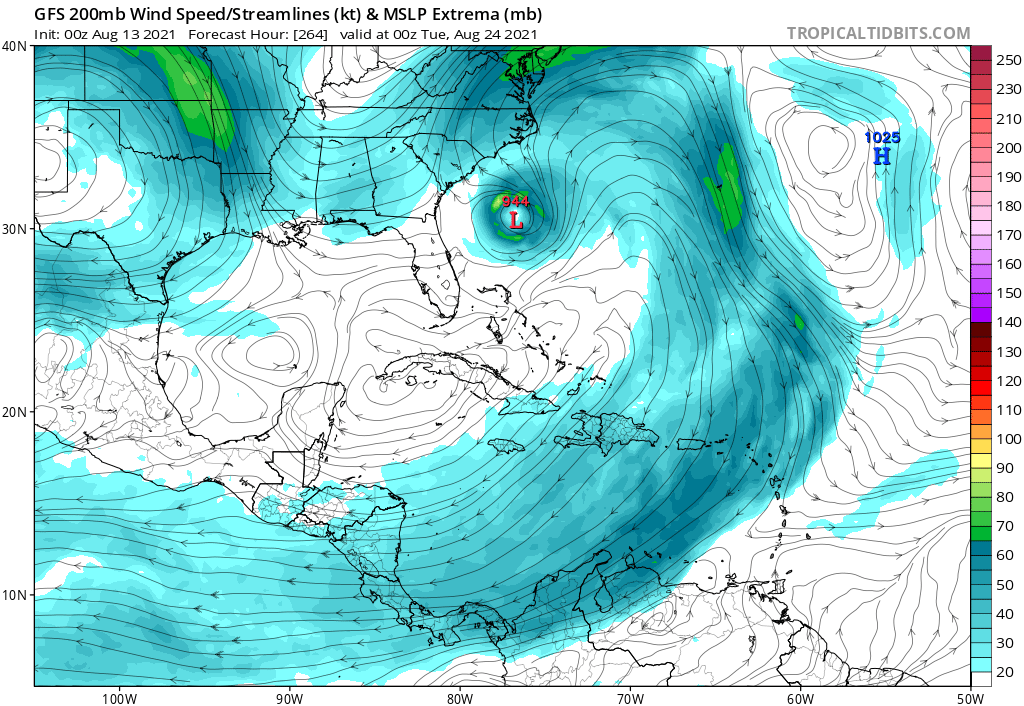
952mb landfall on Outer Banks
0 likes
-
Category5Kaiju
- Category 5
- Posts: 4338
- Joined: Thu Dec 24, 2020 12:45 pm
- Location: Seattle during the summer, Phoenix during the winter
Re: ATL: 95L - Models
I am going to be in college in far Eastern Virginia by the end of this month, and I really despise this GFS run.
0 likes
Unless explicitly stated, all information in my posts is based on my own opinions and observations. Tropical storms and hurricanes can be extremely dangerous. Refer to an accredited weather research agency or meteorologist if you need to make serious decisions regarding an approaching storm.

Re: ATL: 95L - Models
Looks like an enormous category three or four headed for Cape Hatteras
0 likes
-
Keldeo1997
- Category 2

- Posts: 688
- Joined: Fri Oct 11, 2019 11:35 pm
-
ElectricStorm
- Category 5
- Posts: 5148
- Age: 25
- Joined: Tue Aug 13, 2019 11:23 pm
- Location: Norman, OK
Re: ATL: 95L - Models
Look how huge it is! That would be a ton of surge. Luckily this likely won't happen

1 likes
B.S Meteorology, University of Oklahoma '25
Please refer to the NHC, NWS, or SPC for official information.
Please refer to the NHC, NWS, or SPC for official information.
-
Category5Kaiju
- Category 5
- Posts: 4338
- Joined: Thu Dec 24, 2020 12:45 pm
- Location: Seattle during the summer, Phoenix during the winter
Re: ATL: 95L - Models
Fancy1001 wrote:Can we just appreciate how large it gets In this run.
Of course it's one GFS run, but if this verifies, the name "Grace" will almost surely be a retired name and go down in wx history as an infamous storm.
0 likes
Unless explicitly stated, all information in my posts is based on my own opinions and observations. Tropical storms and hurricanes can be extremely dangerous. Refer to an accredited weather research agency or meteorologist if you need to make serious decisions regarding an approaching storm.
-
SouthFLTropics

- Category 5
- Posts: 4258
- Age: 50
- Joined: Thu Aug 14, 2003 8:04 am
- Location: Port St. Lucie, Florida
Re: ATL: 95L - Models
Well that GFS run is basically Dorian 2.0 on the Bahama approach. Things may be interesting with this after all. Looks like lots of model watching ahead.
0 likes
Fourth Generation Florida Native
Personal Storm History: David 79, Andrew 92, Erin 95, Floyd 99, Irene 99, Frances 04, Jeanne 04, Wilma 05, Matthew 16, Irma 17, Ian 22, Nicole 22, Milton 24
Personal Storm History: David 79, Andrew 92, Erin 95, Floyd 99, Irene 99, Frances 04, Jeanne 04, Wilma 05, Matthew 16, Irma 17, Ian 22, Nicole 22, Milton 24
-
Keldeo1997
- Category 2
- Posts: 688
- Joined: Fri Oct 11, 2019 11:35 pm
Re: ATL: 95L - Models
Weather Dude wrote:Look how huge it is! That would be a ton of surge. Luckily this likely won't happen
https://i.imgur.com/uWECXYz.png
That thing could possibly bring 20+ FT of surge of that would happen
0 likes
-
Hurricaneman
- Category 5
- Posts: 7404
- Age: 45
- Joined: Tue Aug 31, 2004 3:24 pm
- Location: central florida
Re: ATL: 95L - Models
SouthFLTropics wrote:Well that GFS run is basically Dorian 2.0 on the Bahama approach. Things may be interesting with this after all. Looks like lots of model watching ahead.
Let’s just hope the models don’t shift southwest over time, that would put Florida in the zone so this bears watching from Boston to possibly the GOM
0 likes
-
Keldeo1997
- Category 2
- Posts: 688
- Joined: Fri Oct 11, 2019 11:35 pm

Re: ATL: 95L - Models
Hurricaneman wrote:SouthFLTropics wrote:Well that GFS run is basically Dorian 2.0 on the Bahama approach. Things may be interesting with this after all. Looks like lots of model watching ahead.
Let’s just hope the models don’t shift southwest over time, that would put Florida in the zone so this bears watching from Boston to possibly the GOM
Yeah imo everywhere is in play right now including a track out to sea. We just need to see how everything sets up.
0 likes
-
SouthFLTropics
- Category 5
- Posts: 4258
- Age: 50
- Joined: Thu Aug 14, 2003 8:04 am
- Location: Port St. Lucie, Florida
Re: ATL: 95L - Models
I think it’s fair to say that is the biggest and strongest run on any storm that I’ve seen the GFS do in a while.
Sent from my iPhone using Tapatalk
Sent from my iPhone using Tapatalk
2 likes
Fourth Generation Florida Native
Personal Storm History: David 79, Andrew 92, Erin 95, Floyd 99, Irene 99, Frances 04, Jeanne 04, Wilma 05, Matthew 16, Irma 17, Ian 22, Nicole 22, Milton 24
Personal Storm History: David 79, Andrew 92, Erin 95, Floyd 99, Irene 99, Frances 04, Jeanne 04, Wilma 05, Matthew 16, Irma 17, Ian 22, Nicole 22, Milton 24
-
Hurricaneman
- Category 5
- Posts: 7404
- Age: 45
- Joined: Tue Aug 31, 2004 3:24 pm
- Location: central florida
Re: ATL: 95L - Models
The key here is some models go through Hispaniola and if that happens not much will be left but if it goes north of PR and Hispaniola the GFS scenario is very plausible and I’m slightly concerned due to the fact that the GFS breaks down ridges too fast and has a NE bias due to that
1 likes
Who is online
Users browsing this forum: No registered users and 12 guests