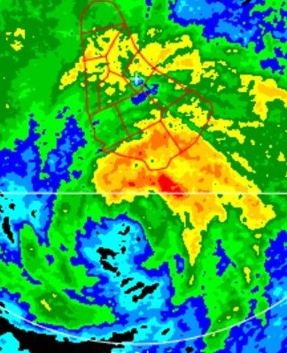
ATL: Remnants of INVEST 95L - Discussion

Moderator: S2k Moderators

Message
Author
Cat5James
Category 1
Category 1
Posts: 392
Joined: Fri Sep 06, 2019 7:54 pm

Re: ATL: INVEST 95L - Discussion

#121 Postby Cat5James » Sun Jun 27, 2021 11:24 am

JRD wrote:At this point I'd personally give 95L a nearly 0% of development over both 2 days and 5 days. It's currently plagued by some wind shear, and while shear levels are more favorable to the west, there's also dry air and Saharan dust there. Shear trends over the Caribbean and SW North Atlantic don't look very favorable either. 95L would have maybe already fallen apart if not for the monsoon trough it's attached to.

I'd let it get past 40W and see what happens before counting 95L out.
6 likes   

JRD
Tropical Depression
Tropical Depression
Posts: 52
Age: 20
Joined: Fri Sep 18, 2020 11:23 am
Location: Allentown, PA

Re: ATL: INVEST 95L - Discussion

#122 Postby JRD » Sun Jun 27, 2021 12:25 pm

L95 has gotten better organized and has deepened a little. I honestly don't know what to say about it, since it's being unpredictable.
1 likes   

User avatar
Stormybajan
Category 1
Category 1
Posts: 428
Joined: Thu May 20, 2021 3:21 pm
Location: Windward Islands

Re: ATL: INVEST 95L - Discussion

#123 Postby Stormybajan » Sun Jun 27, 2021 1:00 pm

JRD wrote:L95 has gotten better organized and has deepened a little. I honestly don't know what to say about it, since it's being unpredictable.


I think I've learnt overs the years watching early season tropical waves is that they always do this...ebb and flow ..convection can increase then suddenly decrease and go poof then be back again. Once theres a area of rotation still intact theres still a chance with this AND its heading to warmer waters right now as others have said I say watch what it does between 40-45W that will tell us a lot
1 likes   
Sad West Indies and Manchester United fan ⚽️

Cat5James
Category 1
Category 1
Posts: 392
Joined: Fri Sep 06, 2019 7:54 pm

Re: ATL: INVEST 95L - Discussion

#124 Postby Cat5James » Sun Jun 27, 2021 1:37 pm

New burst of convection in the last 15-30 minutes
0 likes   

tolakram
Admin
Admin
Posts: 19182
Age: 60
Joined: Sun Aug 27, 2006 8:23 pm
Location: Florence, KY (name is Mark)

Re: ATL: INVEST 95L - Discussion

#125 Postby tolakram » Sun Jun 27, 2021 1:42 pm

1 likes   
M a r k
- - - - -
Join us in chat: Storm2K Chatroom Invite. Android and IOS apps also available.

The posts in this forum are NOT official forecasts and should not be used as such. Posts are NOT endorsed by any professional institution or STORM2K.org. For official information and forecasts, please refer to NHC and NWS products.

User avatar
Nimbus
Category 5
Category 5
Posts: 4933
Joined: Mon Jul 19, 2004 10:54 am

Re: ATL: INVEST 95L - Discussion

#126 Postby Nimbus » Sun Jun 27, 2021 2:14 pm

Moisture seems to be rolling west with 95L so far early season circulations usually dry out till they almost reach the islands.
0 likes   

User avatar
cycloneye
Admin
Admin
Posts: 139593
Age: 67
Joined: Thu Oct 10, 2002 10:54 am
Location: San Juan, Puerto Rico

Re: ATL: INVEST 95L - Discussion

#127 Postby cycloneye » Sun Jun 27, 2021 2:25 pm

AL, 95, 2021062718, , BEST, 0, 108N, 345W, 25, 1009, LO
1 likes   
Visit the Caribbean-Central America Weather Thread where you can find at first post web cams,radars
and observations from Caribbean basin members Click Here

User avatar
cheezyWXguy
Category 5
Category 5
Posts: 5566
Joined: Mon Feb 13, 2006 12:29 am
Location: Dallas, TX

Re: ATL: INVEST 95L - Discussion

#128 Postby cheezyWXguy » Sun Jun 27, 2021 2:31 pm

I have to say, I’m pretty impressed with this system. Pretty well defined circulation and decently deep convection over the center. Is it only the lack of confidence that it will survive that’s keeping this from being classified?
1 likes   

AlphaToOmega
Category 5
Category 5
Posts: 1448
Joined: Sat Jun 26, 2021 10:51 am
Location: Somewhere in Massachusetts

Re: ATL: INVEST 95L - Discussion

#129 Postby AlphaToOmega » Sun Jun 27, 2021 2:33 pm

cheezyWXguy wrote:I have to say, I’m pretty impressed with this system. Pretty well defined circulation and decently deep convection over the center. Is it only the lack of confidence that it will survive that’s keeping this from being classified?


Systems can be re-classified as tropical cyclones in post-season analysis. The last time that happened was 2013.
0 likes   

User avatar
Hammy
Category 5
Category 5
Posts: 5594
Age: 40
Joined: Fri May 25, 2012 5:25 pm
Contact:

Re: ATL: INVEST 95L - Discussion

#130 Postby Hammy » Sun Jun 27, 2021 2:57 pm

cheezyWXguy wrote:I have to say, I’m pretty impressed with this system. Pretty well defined circulation and decently deep convection over the center. Is it only the lack of confidence that it will survive that’s keeping this from being classified?


The mid-level circulation (where the convection is) is displaced by about two degrees from the low level center, which is still fairly diffuse.
1 likes   
The above post is not official and should not be used as such. It is the opinion of the poster and may or may not be backed by sound meteorological data. It is not endorsed by any professional institution or storm2k.org. For official information, please refer to the NHC and NWS products.

User avatar
toad strangler
S2K Supporter
S2K Supporter
Posts: 4178
Joined: Sun Jul 28, 2013 3:09 pm
Location: Earth
Contact:

Re: ATL: INVEST 95L - Discussion

#131 Postby toad strangler » Sun Jun 27, 2021 3:33 pm

cheezyWXguy wrote:I have to say, I’m pretty impressed with this system. Pretty well defined circulation and decently deep convection over the center. Is it only the lack of confidence that it will survive that’s keeping this from being classified?


Nah, sub tropical weak sauce has been classified multiple times in the recent past even though longevity could be expected in hours rather than days. The NHC isn't factoring that in I'm pretty confident.
0 likes   

User avatar
aspen
Category 5
Category 5
Posts: 8061
Joined: Sat Oct 12, 2019 7:10 pm
Location: Connecticut, USA

Re: ATL: INVEST 95L - Discussion

#132 Postby aspen » Sun Jun 27, 2021 3:51 pm

Looks pretty decent right now. Maybe worthy of getting bumped up to a medium chance at 8pm if its current presentation persists.
0 likes   
Irene '11 Sandy '12 Hermine '16 5/15/2018 Derecho Fay '20 Isaias '20 Elsa '21 Henri '21 Ida '21

I am only a meteorology enthusiast who knows a decent amount about tropical cyclones. Look to the professional mets, the NHC, or your local weather office for the best information.

User avatar
ScottNAtlanta
Category 5
Category 5
Posts: 2014
Joined: Sat May 25, 2013 3:11 pm
Location: Atlanta, GA

Re: ATL: INVEST 95L - Discussion

#133 Postby ScottNAtlanta » Sun Jun 27, 2021 3:51 pm

It still looks like a sharp trough axis to me. I dont see any westerly low level flow right now, but it is holding its own through the cooler water
0 likes   
The posts in this forum are NOT official forecast and should not be used as such. They are just the opinion of the poster and may or may not be backed by sound meteorological data. They are NOT endorsed by any professional institution or storm2k.org. For official information, please refer to the NHC and NWS products.

User avatar
Category5Kaiju
Category 5
Category 5
Posts: 3438
Age: 22
Joined: Thu Dec 24, 2020 12:45 pm
Location: Seattle

Re: ATL: INVEST 95L - Discussion

#134 Postby Category5Kaiju » Sun Jun 27, 2021 3:55 pm

Apparently the convective burst is occurring during dirunal minimum, so one would have to wonder what diurnal maximum would mean for 95L
2 likes   
Unless explicitly stated, all information covered in my posts is based on my opinions and observations. Please refer to a professional meteorologist or an accredited weather research agency otherwise, especially if serious decisions must be made in the event of a potentially life-threatening tropical storm or hurricane.

User avatar
Stormybajan
Category 1
Category 1
Posts: 428
Joined: Thu May 20, 2021 3:21 pm
Location: Windward Islands

Re: ATL: INVEST 95L - Discussion

#135 Postby Stormybajan » Sun Jun 27, 2021 5:19 pm

Pretty decent convective burst right now...and its heading for warmer waters over the next day or so. IMO chances are increasing for atleast a short lived TD out of this in the next 5 days
0 likes   
Sad West Indies and Manchester United fan ⚽️

AlphaToOmega
Category 5
Category 5
Posts: 1448
Joined: Sat Jun 26, 2021 10:51 am
Location: Somewhere in Massachusetts

Re: ATL: INVEST 95L - Discussion

#136 Postby AlphaToOmega » Sun Jun 27, 2021 5:22 pm

The chances will probably be upgraded to something like 30% within 2 days and 50% within 5 days.
1 likes   

Aric Dunn
Category 5
Category 5
Posts: 21228
Age: 41
Joined: Sun Sep 19, 2004 9:58 pm
Location: Ready for the Chase.
Contact:

Re: ATL: INVEST 95L - Discussion

#137 Postby Aric Dunn » Sun Jun 27, 2021 5:33 pm

This is the type of sustained convection it has needed. last night was impressive but it kept collapsing and refiring too quickly.
0 likes   
Note: If I make a post that is brief. Please refer back to previous posts for the analysis or reasoning. I do not re-write/qoute what my initial post said each time.
If there is nothing before... then just ask :)

Space & Atmospheric Physicist, Embry-Riddle Aeronautical University,
I believe the sky is falling...

User avatar
Hypercane_Kyle
Category 5
Category 5
Posts: 2902
Joined: Sat Mar 07, 2015 7:58 pm
Location: Cape Canaveral, FL

Re: ATL: INVEST 95L - Discussion

#138 Postby Hypercane_Kyle » Sun Jun 27, 2021 5:49 pm

A lot of upper divergence but lacking in lower convergence. Gonna be tough to continue generating thunderstorms throughout the night.

Image
1 likes   
My posts are my own personal opinion, defer to the National Hurricane Center (NHC) and other NOAA products for decision making during hurricane season.

User avatar
ScottNAtlanta
Category 5
Category 5
Posts: 2014
Joined: Sat May 25, 2013 3:11 pm
Location: Atlanta, GA

Re: ATL: INVEST 95L - Discussion

#139 Postby ScottNAtlanta » Sun Jun 27, 2021 6:06 pm

These little systems can wrap before you know it. It looks a whole lot better than it did earlier today
2 likes   
The posts in this forum are NOT official forecast and should not be used as such. They are just the opinion of the poster and may or may not be backed by sound meteorological data. They are NOT endorsed by any professional institution or storm2k.org. For official information, please refer to the NHC and NWS products.

User avatar
abajan
S2K Supporter
S2K Supporter
Posts: 4175
Joined: Sun Sep 07, 2003 5:10 am
Location: Barbados

Re: ATL: INVEST 95L - Discussion

#140 Postby abajan » Sun Jun 27, 2021 6:41 pm

Tropical Weather Outlook
NWS National Hurricane Center Miami FL
800 PM EDT Sun Jun 27 2021

For the North Atlantic...Caribbean Sea and the Gulf of Mexico:
...

2. An area of low pressure associated with a tropical wave is
producing a small cluster of showers and thunderstorms over the
eastern tropical Atlantic Ocean. Some slow development is possible
through the end of the week while this system moves quickly westward
to west-northwestward at about 20 mph, likely reaching the Lesser
Antilles late Wednesday or Wednesday night.

* Formation chance through 48 hours...low...20 percent.
* Formation chance through 5 days...low...30 percent.

$$
Forecaster Berg/Brown

Image
1 likes   


Return to “2021”

Who is online

Users browsing this forum: Google [Bot] and 2 guests