ATL: ISAIAS - Models

Moderator: S2k Moderators

Message
Author
HurricaneFrances04
Category 2
Category 2
Posts: 595
Joined: Mon Jun 25, 2012 8:09 am
Location: Fort Lauderdale, Florida

Re: ATL: INVEST 92L - Models

#81 Postby HurricaneFrances04 » Sat Jul 25, 2020 6:52 am

SHIPS joins the EURO in being less bullish

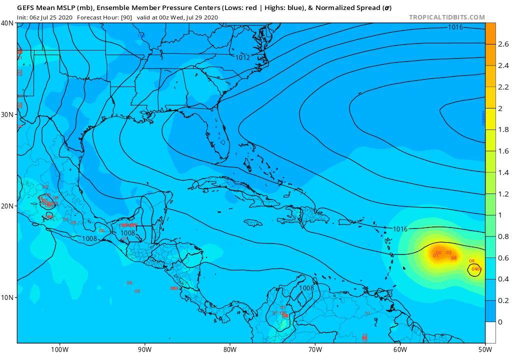
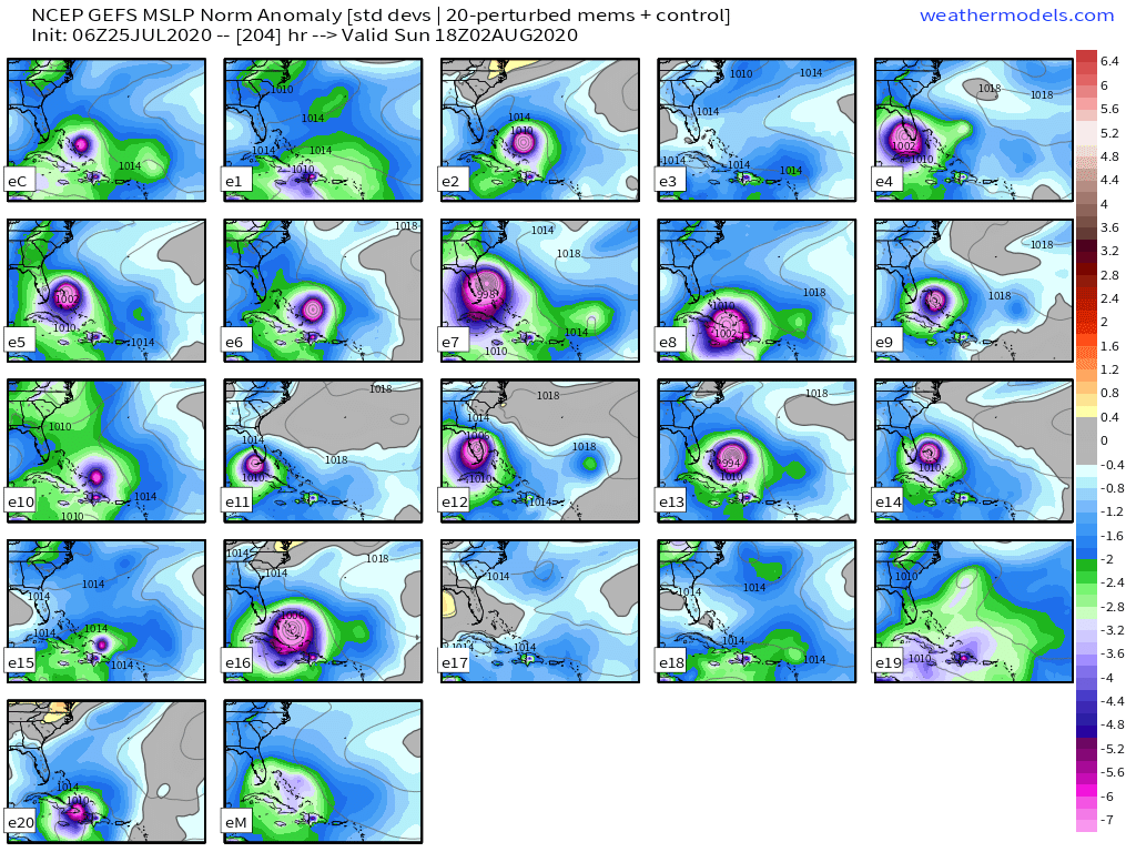
* INVEST AL922020 07/25/20 06 UTC *

TIME (HR) 0 6 12 18 24 36 48 60 72 84 96 108 120 132 144 156 168
V (KT) NO LAND 20 21 22 23 24 29 36 43 49 55 61 66 69 70 71 74 74
V (KT) LAND 20 21 22 23 24 29 36 43 49 55 61 66 69 70 71 74 74
V (KT) LGEM 20 20 20 21 21 22 23 25 27 29 31 32 34 34 34 33 32
Storm Type TROP TROP TROP TROP TROP TROP TROP TROP TROP TROP TROP TROP TROP TROP TROP TROP TROP

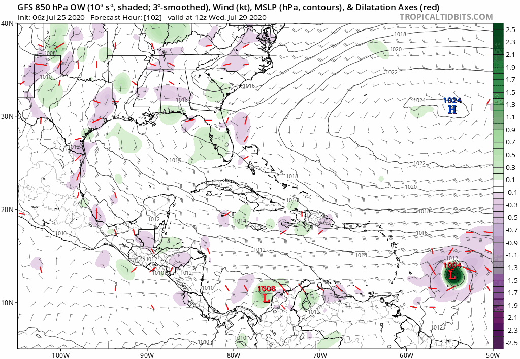
SHEAR (KT) 16 12 14 13 11 14 6 4 5 3 13 14 23 24 28 23 23
SHEAR ADJ (KT) 7 10 8 9 6 -1 2 5 5 3 0 -3 0 -2 -1 -1 0
SHEAR DIR 57 52 56 65 67 79 129 207 258 246 271 272 251 256 247 236 233
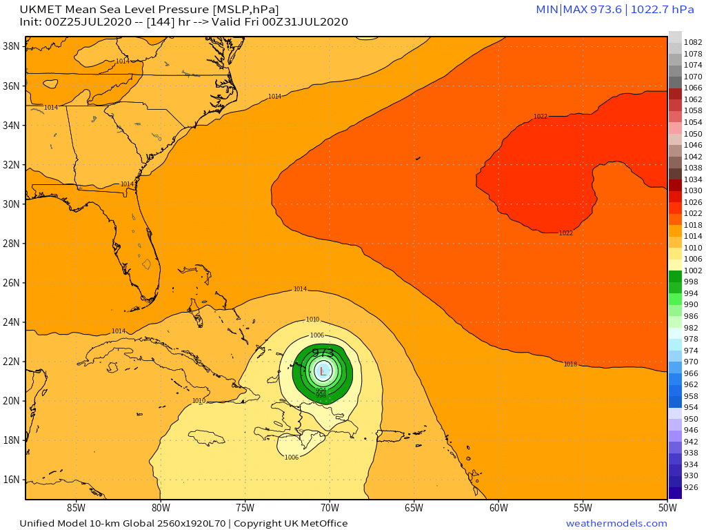
SST (C) 27.6 27.9 27.9 27.9 27.6 27.8 27.4 26.9 26.9 26.6 26.9 27.6 27.9 28.1 28.6 28.8 28.9
POT. INT. (KT) 133 137 137 137 133 136 131 125 125 122 125 134 138 140 147 150 151
ADJ. POT. INT. 133 137 137 137 133 136 131 125 125 120 125 134 138 139 144 144 145
200 MB T (C) -53.4 -53.5 -53.3 -53.7 -54.0 -53.4 -53.5 -53.0 -53.5 -53.4 -53.6 -53.5 -53.4 -53.2 -53.3 -53.1 -53.1
200 MB VXT (C) 0.0 0.0 0.0 0.0 0.0 0.0 0.0 0.0 0.0 0.0 0.0 0.0 0.0 0.0 0.0 0.0 0.0
TH_E DEV (C) 4 4 4 4 4 5 5 5 5 6 6 7 8 9 9 10 10
700-500 MB RH 69 71 71 68 66 59 58 57 55 49 47 44 43 46 46 50 52
MODEL VTX (KT) 0 LOST LOST LOST LOST LOST LOST LOST LOST LOST LOST LOST LOST LOST LOST LOST LOST
850 MB ENV VOR 66 62 60 66 67 54 32 26 43 49 46 31 27 29 31 20 4
200 MB DIV 28 50 60 73 55 18 15 -31 -22 -4 7 20 19 25 14 8 -2
700-850 TADV -10 -13 -15 -12 -5 -7 -7 -11 -6 -7 2 1 6 -3 0 1 0
LAND (KM) 833 966 1090 1225 1380 1695 1816 1647 1411 1243 1117 1076 814 708 418 138 133
LAT (DEG N) 11.3 11.6 12.1 12.5 12.7 13.0 13.0 13.3 13.4 13.9 14.4 15.2 15.8 xx.x xx.x xx.x xx.x
LONG(DEG W) 24.4 25.8 27.2 28.6 30.1 33.1 36.2 39.5 42.6 45.7 48.8 52.1 55.5 xxx.x xxx.x xxx.x xxx.x
STM SPEED (KT) 13 14 14 14 15 15 16 15 16 15 16 16 17 16 15 13 13
HEAT CONTENT 12 13 13 13 10 9 13 6 5 6 8 19 26 34 28 51 50
0 likes   

User avatar
SFLcane
S2K Supporter
S2K Supporter
Posts: 9627
Age: 46
Joined: Sat Jun 05, 2010 1:44 pm
Location: Lake Worth Florida

Re: ATL: INVEST 92L - Models

#82 Postby SFLcane » Sat Jul 25, 2020 7:10 am

06z GFS ensembles..Stronger

Image
5 likes   

User avatar
SFLcane
S2K Supporter
S2K Supporter
Posts: 9627
Age: 46
Joined: Sat Jun 05, 2010 1:44 pm
Location: Lake Worth Florida

Re: ATL: INVEST 92L - Models

#83 Postby SFLcane » Sat Jul 25, 2020 7:19 am

Another look at the GFS ensembles.

Image
5 likes   

Shell Mound
Category 5
Category 5
Posts: 2434
Age: 31
Joined: Thu Sep 07, 2017 3:39 pm
Location: St. Petersburg, FL → Scandinavia

Re: ATL: INVEST 92L - Models

#84 Postby Shell Mound » Sat Jul 25, 2020 7:23 am

SFLcane wrote:06z GFS ensembles..Stronger

https://iili.io/dIQ0lI.gif

Interestingly, as of 06Z virtually all of the strongest GEFS ensemble members take 92L/Isaias into South/Central Florida. (The weaker members either head toward the Carolinas or enter the Caribbean.) These members suggest a track over or near Puerto Rico that only clips the northern side of the Dominican Republic. Notably, the northern portion of the Dominican Republic is relatively flat, hence less weakening due to interaction with land. So the fact that those GEFS members which deepen 92L/Isaias fastest also strongly favour a track from PR to South/Central FL is disconcerting.
3 likes   
CVW / MiamiensisWx / Shell Mound
The posts in this forum are NOT official forecasts and should not be used as such. They are just the opinion of the poster and may or may not be backed by sound meteorological data. They are NOT endorsed by any professional institution or STORM2K. For official information, please refer to products from the NHC and NWS.

User avatar
northjaxpro
S2K Supporter
S2K Supporter
Posts: 8900
Joined: Mon Sep 27, 2010 11:21 am
Location: Jacksonville, FL

Re: ATL: INVEST 92L - Models

#85 Postby northjaxpro » Sat Jul 25, 2020 7:29 am

Shell Mound wrote:
SFLcane wrote:06z GFS ensembles..Stronger

https://iili.io/dIQ0lI.gif

Interestingly, as of 06Z virtually all of the strongest GEFS ensemble members take 92L/Isaias into South/Central Florida. (The weaker members either head toward the Carolinas or enter the Caribbean.) These members suggest a track over or near Puerto Rico that only clips the northern side of the Dominican Republic. Notably, the northern portion of the Dominican Republic is relatively flat, hence less weakening due to interaction with land. So the fact that those GEFS members which deepen 92L/Isaias fastest also strongly favour a track from PR to South/Central FL is disconcerting.


Yes, if this trend continues, it is very disconcerting . This system is lookiing more and more to be a very major threat to those areas in Florida, along with the Bahamas and along the Southeast U.S. coast.
0 likes   
NEVER, EVER SAY NEVER in the tropics and weather in general, and most importantly, with life itself!!

________________________________________________________________________________________

Fay 2008 Beryl 2012 Debby 2012 Colin 2016 Hermine 2016 Julia 2016 Matthew 2016 Irma 2017 Dorian 2019

User avatar
TheStormExpert
Category 5
Category 5
Posts: 8487
Age: 30
Joined: Wed Feb 16, 2011 5:38 pm
Location: Palm Beach Gardens, FL

Re: ATL: INVEST 92L - Models

#86 Postby TheStormExpert » Sat Jul 25, 2020 7:43 am

aspen wrote:
SFLcane wrote:06z GFS similar to some EPS members.

https://iili.io/dIsMgt.gif

I can’t be the only one getting Dorian vibes from that track. Starts as a low rider in the MDR, pulls north at the Lesser Antilles, passes through the Greater Antilles, and heads into the Bahamas.

Definitely expect Dorian went more due north of Puerto Rico before heading more due west towards The Abacos and Grand Bahama.
0 likes   
The following post is NOT an official forecast and should not be used as such. It is just the opinion of the poster and may or may not be backed by sound meteorological data. It is NOT endorsed by storm2k.org.

User avatar
SFLcane
S2K Supporter
S2K Supporter
Posts: 9627
Age: 46
Joined: Sat Jun 05, 2010 1:44 pm
Location: Lake Worth Florida

Re: ATL: INVEST 92L - Models

#87 Postby SFLcane » Sat Jul 25, 2020 7:47 am

Ukmet...00z :eek:

Image
2 likes   

User avatar
Ivanhater
Storm2k Moderator
Storm2k Moderator
Posts: 10859
Age: 37
Joined: Fri Jul 01, 2005 8:25 am
Location: Pensacola

Re: ATL: INVEST 92L - Models

#88 Postby Ivanhater » Sat Jul 25, 2020 7:54 am

Quite a few ensembles and operational Euro bring this into the Gulf. Still way too far out
2 likes   
Michael

AutoPenalti
Category 5
Category 5
Posts: 3950
Age: 27
Joined: Mon Aug 17, 2015 4:16 pm
Location: Ft. Lauderdale, Florida

Re: ATL: INVEST 92L - Models

#89 Postby AutoPenalti » Sat Jul 25, 2020 7:56 am

It’s 9 days out but it’s creeping me out that guidance is in such agreement past 5 days...

There’s still some members bringing this into the gulf.
0 likes   
The posts in this forum are NOT official forecasts and should not be used as such. They are just the opinion of the poster and may or may not be backed by sound meteorological data. They are NOT endorsed by any professional institution or STORM2K. For official information, please refer to products from the NHC and NWS.


Model Runs Cheat Sheet:
GFS (5:30 AM/PM, 11:30 AM/PM)
HWRF, GFDL, UKMET, NAVGEM (6:30-8:00 AM/PM, 12:30-2:00 AM/PM)
ECMWF (1:45 AM/PM)

TCVN
is a weighted averaged

User avatar
toad strangler
S2K Supporter
S2K Supporter
Posts: 4178
Joined: Sun Jul 28, 2013 3:09 pm
Location: Earth
Contact:

Re: ATL: INVEST 92L - Models

#90 Postby toad strangler » Sat Jul 25, 2020 8:23 am

Did the 00z Euro cancel the season? :ggreen:
2 likes   

SootyTern
S2K Supporter
S2K Supporter
Posts: 310
Age: 55
Joined: Sun Sep 05, 2004 5:09 pm
Location: NYC (formerly Homestead, FL)

Re: ATL: INVEST 92L - Models

#91 Postby SootyTern » Sat Jul 25, 2020 8:26 am

Those 06Z GFS ensembles seem very clustered over PR-Bahamas through Aug 2
0 likes   
Disclaimer:
The posts in this forum are NOT official forecasts and should not be used as such. For official information, please refer to the NHC and NWS products.

Gulf Coast: Opal '95 Georges '98 / So Fla: Katrina '05 Wilma '05 Irma '17

HurricaneFrances04
Category 2
Category 2
Posts: 595
Joined: Mon Jun 25, 2012 8:09 am
Location: Fort Lauderdale, Florida

Re: ATL: INVEST 92L - Models

#92 Postby HurricaneFrances04 » Sat Jul 25, 2020 8:36 am

Speed may be a factor. EURO is faster and weaker, GFS and CMC are slower and stronger

Image
3 likes   

User avatar
ronjon
Category 5
Category 5
Posts: 4672
Joined: Fri Aug 19, 2005 5:17 pm
Location: Hernando Beach, FL

Re: ATL: INVEST 92L - Models

#93 Postby ronjon » Sat Jul 25, 2020 9:27 am

Difference between Euro and GFS/CMC is obviously the strength of the system but also Euro has more 500 mb ridging off the SE coast and midlevel low pressure centered further west in Tx-La rather than further east per GFS. It's also 10 days out...alot will change.

https://www.tropicaltidbits.com/analysis/models/?model=ecmwf&region=watl&pkg=z500aNorm&runtime=2020072500&fh=240
0 likes   

User avatar
Blown Away
S2K Supporter
S2K Supporter
Posts: 9874
Joined: Wed May 26, 2004 6:17 am

Re: ATL: INVEST 92L - Models

#94 Postby Blown Away » Sat Jul 25, 2020 9:49 am

Ivanhater wrote:Quite a few ensembles and operational Euro bring this into the Gulf. Still way too far out


Yeah, it appears this will be the classic if 92L is weaker/shallower the farther west it will go. Typically if 92L stays a wave into the E Caribbean it likely increases the chances of a GOMER. JMHO :D
0 likes   
Hurricane Eye Experience: David 79, Irene 99, Frances 04, Jeanne 04, Wilma 05... EYE COMING MY WAY IN 2024…
Hurricane Brush Experience: Andrew 92, Erin 95, Floyd 99, Matthew 16, Irma 17, Ian 22, Nicole 22…

jlauderdal
S2K Supporter
S2K Supporter
Posts: 6813
Joined: Wed May 19, 2004 5:46 am
Location: NE Fort Lauderdale
Contact:

Re: ATL: INVEST 92L - Models

#95 Postby jlauderdal » Sat Jul 25, 2020 9:55 am

ronjon wrote:Difference between Euro and GFS/CMC is obviously the strength of the system but also Euro has more 500 mb ridging off the SE coast and midlevel low pressure centered further west in Tx-La rather than further east per GFS. It's also 10 days out...alot will change.

https://www.tropicaltidbits.com/analysis/models/?model=ecmwf&region=watl&pkg=z500aNorm&runtime=2020072500&fh=240
we usually don't see the gfs and euro this far out seeing things this similar, couple of days ago the euro didn't have that much ridging in place an in fact had a significant break in the ridge providing a healthy path OTS, that has changed significantly. Will have to see how things develop upstream middle of next week to see if we can get some roughing in place..if im in the windward and leewards, PR, Dr and cooba, im starting the Genny and re-stocking, the modeling is on board with a significant system making it across
0 likes   

User avatar
toad strangler
S2K Supporter
S2K Supporter
Posts: 4178
Joined: Sun Jul 28, 2013 3:09 pm
Location: Earth
Contact:

Re: ATL: INVEST 92L - Models

#96 Postby toad strangler » Sat Jul 25, 2020 10:05 am

0 likes   

typhoonty
Tropical Depression
Tropical Depression
Posts: 95
Age: 29
Joined: Wed May 31, 2017 10:37 pm
Location: Fort Myers / Tallahassee, FL
Contact:

Re: ATL: INVEST 92L - Models

#97 Postby typhoonty » Sat Jul 25, 2020 10:48 am

Shell Mound wrote:
SFLcane wrote:06z GFS ensembles..Stronger

https://iili.io/dIQ0lI.gif

Interestingly, as of 06Z virtually all of the strongest GEFS ensemble members take 92L/Isaias into South/Central Florida. (The weaker members either head toward the Carolinas or enter the Caribbean.) These members suggest a track over or near Puerto Rico that only clips the northern side of the Dominican Republic. Notably, the northern portion of the Dominican Republic is relatively flat, hence less weakening due to interaction with land. So the fact that those GEFS members which deepen 92L/Isaias fastest also strongly favour a track from PR to South/Central FL is disconcerting.


Wasn't it you that said that Florida was "off the hook" for this season last week?
0 likes   
FSU Meteorology student, opinions are mine, 18 years experience covering TC's, consult NHC/Local officials when making decisions.

Gabrielle '01, Michelle '01, Charley '04, Frances '04, Dennis '05, Katrina '05, Rita '05, Wilma '05, Fay '08, Isaac '12 Hermine '16, Irma '17, Gordon '18, Michael '18, Eta '20 IAN '22

User avatar
toad strangler
S2K Supporter
S2K Supporter
Posts: 4178
Joined: Sun Jul 28, 2013 3:09 pm
Location: Earth
Contact:

Re: ATL: INVEST 92L - Models

#98 Postby toad strangler » Sat Jul 25, 2020 10:52 am

typhoonty wrote:
Shell Mound wrote:
SFLcane wrote:06z GFS ensembles..Stronger

https://iili.io/dIQ0lI.gif

Interestingly, as of 06Z virtually all of the strongest GEFS ensemble members take 92L/Isaias into South/Central Florida. (The weaker members either head toward the Carolinas or enter the Caribbean.) These members suggest a track over or near Puerto Rico that only clips the northern side of the Dominican Republic. Notably, the northern portion of the Dominican Republic is relatively flat, hence less weakening due to interaction with land. So the fact that those GEFS members which deepen 92L/Isaias fastest also strongly favour a track from PR to South/Central FL is disconcerting.


Wasn't it you that said that Florida was "off the hook" for this season last week?


The moundster has said it several times at varying intervals. He vacillates between FL is safe and Fl is doomed. I lost count. :D

12z GFS showing modest development again through 84 hours
4 likes   

HurricaneFrances04
Category 2
Category 2
Posts: 595
Joined: Mon Jun 25, 2012 8:09 am
Location: Fort Lauderdale, Florida

Re: ATL: INVEST 92L - Models

#99 Postby HurricaneFrances04 » Sat Jul 25, 2020 11:05 am

12z GFS with a shift to the north. 0Z Euro is an outlier.
0 likes   

User avatar
toad strangler
S2K Supporter
S2K Supporter
Posts: 4178
Joined: Sun Jul 28, 2013 3:09 pm
Location: Earth
Contact:

Re: ATL: INVEST 92L - Models

#100 Postby toad strangler » Sat Jul 25, 2020 11:05 am

12z Goofus coming in further N and a bit stronger than the last couple runs.
5 likes   


Return to “2020”

Who is online

Users browsing this forum: No registered users and 6 guests