ATL: SALLY - Post-Tropical - Discussion
Moderator: S2k Moderators

Re: ATL: NINETEEN - Tropical Depression - Discussion
When it moves into the gulf could see rapid intensification maybe??
0 likes

Re: ATL: NINETEEN - Tropical Depression - Discussion
xironman wrote:The center could easily migrate to that convective burst over the northern keys.
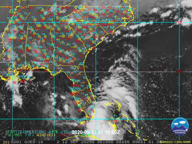
Even without any migration /reformation it’s south of the NHC track forecast path thus far. The center seems to moving into Ponce de Leon bay now.
0 likes
The following post is NOT an official forecast and should not be used as such. It is just the opinion of the poster and may or may not be backed by sound meteorological data. It is NOT endorsed by any professional institution including storm2k.org For Official Information please refer to the NHC and NWS products.
Re: ATL: NINETEEN - Tropical Depression - Discussion
For the area off the keys
Special Marine Warning
GMZ052-072-121115-
/O.NEW.KKEY.MA.W.0341.200912T1033Z-200912T1115Z/
BULLETIN - IMMEDIATE BROADCAST REQUESTED
Special Marine Warning
National Weather Service Key West FL
633 AM EDT Sat Sep 12 2020
The National Weather Service in Key West has issued a
* Special Marine Warning for...
Straits of Florida from Ocean Reef to Craig Key out 60 nm...
* Until 715 AM EDT.
* At 632 AM EDT, strong thunderstorms with possible waterspouts were
located along a line extending from 10 nm east of Islamorada Hump
to 5 nm northeast of Floyd`s Wall Northeast, moving northeast at
20 knots.
HAZARD...Waterspouts and wind gusts 34 knots or greater.
SOURCE...National Weather Service Meteorologist.
IMPACT...Waterspouts can quickly form and capsize boats, cause
considerable damage to vessels and create suddenly higher
waves. Expect wind gusts in excess of 34 knots, suddenly
higher waves, frequent lightning, and heavy downpours.
* Strong thunderstorms will remain over mainly open waters.
PRECAUTIONARY/PREPAREDNESS ACTIONS...
Boaters should seek safe harbor now, and remain there until
threatening weather has passed.
&&
LAT...LON 2517 8023 2492 7989 2463 8010 2485 8041
TIME...MOT...LOC 1032Z 205DEG 20KT 2484 8027 2473 8013
WATERSPOUT...POSSIBLE
HAIL...0.00IN
0 likes

Re: ATL: NINETEEN - Tropical Depression - Discussion
NDG wrote:Homestead reported a pressure of 1003mb when the LLC passed over it, winds gusted over 40 mph.
https://www.wrh.noaa.gov/mesowest/times ... aw=0&w=325
Clear flip in wind direction for NNE to SE at 2 AM.
https://www.ndbc.noaa.gov/station_page. ... tion=fwyf1
New burst of convection as the LLC tracks over the Florida Everglades this morning.
0 likes
-
jlauderdal
- S2K Supporter

- Posts: 7240
- Joined: Wed May 19, 2004 5:46 am
- Location: NE Fort Lauderdale
- Contact:
Re: ATL: NINETEEN - Tropical Depression - Discussion
Well we survived a very tense overnight period, damage assessment complete...  It made a good run at TS status, convective envelope seems to be stationary for now...land interaction may have put the brakes on forward progress. Lets hope it behaves in the gulf, Laura was enough for our friends to the NW.
This system should serve as a warning for the rest of the season, I know the cape verde systems get the headlines but beware, west of 60 is far more dangerous for the united states.
This system should serve as a warning for the rest of the season, I know the cape verde systems get the headlines but beware, west of 60 is far more dangerous for the united states.
7 likes

Re: ATL: NINETEEN - Tropical Depression - Discussion
Like I mentioned last night, the northerly shear was going to keep the LLC on a further southern track and so it has, it is about to get back into the gulf much quicker and more south than forecasted.
The 12z models will be interesting to see.
The 12z models will be interesting to see.
0 likes

Re: ATL: NINETEEN - Tropical Depression - Discussion
Appears to be tightening up and intensifying.
Well south of forecast track.


Well south of forecast track.
1 likes

-
gatorcane

- S2K Supporter
- Posts: 23708
- Age: 48
- Joined: Sun Mar 13, 2005 3:54 pm
- Location: Boca Raton, FL
Re: ATL: NINETEEN - Tropical Depression - Discussion
NDG wrote:Like I mentioned last night, the northerly shear was going to keep the LLC on a further southern track and so it has, it is about to get back into the gulf much quicker and more south than forecasted.
The 12z models will be interesting to see.
Yes seems more south so good call on that. It looks like it should have more time over water which won’t be good.
Saved loop:
3 likes

Re: ATL: NINETEEN - Tropical Depression - Discussion
NDG wrote:Like I mentioned last night, the northerly shear was going to keep the LLC on a further southern track and so it has, it is about to get back into the gulf much quicker and more south than forecasted.
The 12z models will be interesting to see.
One weather youtuber last night said if went south then could head to texas. he showed ensembles that had two bundles, if went north then ms/al. if went south would miss the trough head to la/tx.
0 likes
Robbielyn McCrary
I know just about enough to sound like I know what I'm talking about sometimes. But for your safety please follow the nhc for truly professional forecasting.
I know just about enough to sound like I know what I'm talking about sometimes. But for your safety please follow the nhc for truly professional forecasting.
Re: ATL: NINETEEN - Tropical Depression - Discussion
The tower in the Keys is definitely pulling the surface low to the south into the Florida Bay.
0 likes
Re: ATL: NINETEEN - Tropical Depression - Discussion
Steering is changing from WNW to more NW

1 likes

Re: ATL: NINETEEN - Tropical Depression - Discussion
The sun is out in Coconut Creek and I said to myself last night this is a Keys storm.
0 likes
-
stormlover2013
Re: ATL: NINETEEN - Tropical Depression - Discussion
It will be interesting to see the 12z early models to see if they shift with the further south fix at 12z by the NHC.
0 likes
-
stormlover2013
Re: ATL: NINETEEN - Tropical Depression - Discussion
NDG wrote:It will be interesting to see the 12z early models to see if they shift with the further south fix at 12z by the NHC.
Pin point on radar where center is at please
0 likes
Re: ATL: NINETEEN - Tropical Depression - Discussion
stormlover2013 wrote:Is it going through the straits now ?
http://mp1.met.psu.edu/~fxg1/SAT_ATL/atlanim8ir.html
That's the mid level circulation, the LLC is inland on the SW tip of the Peninsula/Monroe County about to come out on to the GOM.
0 likes
-
cajungal

- Category 5

- Posts: 2354
- Age: 49
- Joined: Sun Mar 14, 2004 9:34 pm
- Location: Schriever, Louisiana (60 miles southwest of New Orleans)
Re: ATL: NINETEEN - Tropical Depression - Discussion
NDG wrote:It will be interesting to see the 12z early models to see if they shift with the further south fix at 12z by the NHC.
Would a shift further south shift the track further west like the euro?
0 likes
-
DestinHurricane

- Category 4

- Posts: 935
- Joined: Tue May 01, 2018 8:05 am
- Location: New York, NY
Re: ATL: NINETEEN - Tropical Depression - Discussion
cajungal wrote:NDG wrote:It will be interesting to see the 12z early models to see if they shift with the further south fix at 12z by the NHC.
Would a shift further south shift the track further west like the euro?
Maybe, maybe not. If it is stronger because of it then maybe it will move north. If it's still weak then will go west.
0 likes
Michael 2018
Re: ATL: NINETEEN - Tropical Depression - Discussion
stormlover2013 wrote:NDG wrote:It will be interesting to see the 12z early models to see if they shift with the further south fix at 12z by the NHC.
Pin point on radar where center is at please

2 likes
Who is online
Users browsing this forum: No registered users and 72 guests