ATL: ISAIAS - Models
Moderator: S2k Moderators
-
Hurricaneman

- Category 5

- Posts: 7404
- Age: 45
- Joined: Tue Aug 31, 2004 3:24 pm
- Location: central florida
Re: ATL: INVEST 92L - Models
Yep, the Euro might just be leading the charge on this one, anyone from the Yucatán to Atlantic Canada need to keep close tabs on this
0 likes
-
DorkyMcDorkface

- Category 4

- Posts: 990
- Age: 28
- Joined: Mon Sep 30, 2019 1:32 pm
- Location: Mid-Atlantic
Re: ATL: INVEST 92L - Models
GFS has definitely caved folks...
Also 18z EPS is starting to get into the "scary" range...

Also 18z EPS is starting to get into the "scary" range...
2 likes
Please note the thougths expressed by this account are solely those of the user and are from a hobbyist perspective. For more comprehensive analysis, consult an actual professional meteorologist or meteorology agency.
Floyd 1999 | Isabel 2003 | Hanna 2008 | Irene 2011 | Sandy 2012 | Isaias 2020
-
HurricaneFrances04
- Category 2

- Posts: 597
- Joined: Mon Jun 25, 2012 8:09 am
- Location: Fort Lauderdale, Florida

-
AutoPenalti
- Category 5
- Posts: 4091
- Age: 29
- Joined: Mon Aug 17, 2015 4:16 pm
- Location: Ft. Lauderdale, Florida
Re: ATL: INVEST 92L - Models
There’s the drop... GFS finally caved in.
0 likes
The posts in this forum are NOT official forecasts and should not be used as such. They are just the opinion of the poster and may or may not be backed by sound meteorological data. They are NOT endorsed by any professional institution or STORM2K. For official information, please refer to products from the NHC and NWS.
Model Runs Cheat Sheet:
GFS (5:30 AM/PM, 11:30 AM/PM)
HWRF, GFDL, UKMET, NAVGEM (6:30-8:00 AM/PM, 12:30-2:00 AM/PM)
ECMWF (1:45 AM/PM)
TCVN is a weighted averaged
-
DorkyMcDorkface
- Category 4
- Posts: 990
- Age: 28
- Joined: Mon Sep 30, 2019 1:32 pm
- Location: Mid-Atlantic
Re: ATL: INVEST 92L - Models
UHHHHHHHHHHH.... 
NEW TROPICAL CYCLONE FORECAST TO DEVELOP AFTER 60 HOURS
FORECAST POSITION AT T+ 60 : 13.3N 45.0W
LEAD CENTRAL MAXIMUM WIND
VERIFYING TIME TIME POSITION PRESSURE (MB) SPEED (KNOTS)
-------------- ---- -------- ------------- -------------
1200UTC 27.07.2020 60 13.3N 45.0W 1008 31
0000UTC 28.07.2020 72 13.6N 49.0W 1007 33
1200UTC 28.07.2020 84 14.1N 53.4W 1006 36
0000UTC 29.07.2020 96 15.4N 57.3W 1003 40
1200UTC 29.07.2020 108 16.7N 60.9W 1000 43
0000UTC 30.07.2020 120 18.2N 64.9W 994 50
1200UTC 30.07.2020 132 19.7N 68.0W 988 54
0000UTC 31.07.2020 144 21.4N 70.5W 972 74
1 likes
Please note the thougths expressed by this account are solely those of the user and are from a hobbyist perspective. For more comprehensive analysis, consult an actual professional meteorologist or meteorology agency.
Floyd 1999 | Isabel 2003 | Hanna 2008 | Irene 2011 | Sandy 2012 | Isaias 2020
-
HurricaneFrances04
- Category 2
- Posts: 597
- Joined: Mon Jun 25, 2012 8:09 am
- Location: Fort Lauderdale, Florida
Re: ATL: INVEST 92L - Models
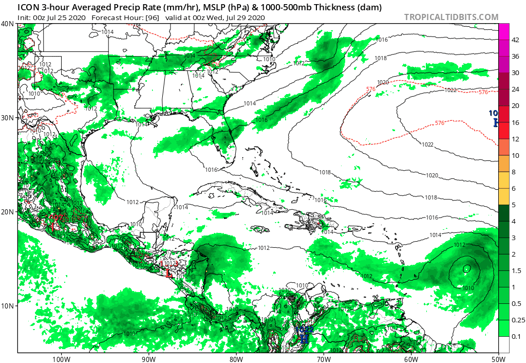
Another track headed for the Dominican Republic, although GFS is fairly weak. Also noted the ICON isn't as strong as the 12Z.

0 likes
-
Hurricaneman
- Category 5
- Posts: 7404
- Age: 45
- Joined: Tue Aug 31, 2004 3:24 pm
- Location: central florida
Re: ATL: INVEST 92L - Models
The UKMET is 40 miles north of Hispaniola at the end of the run with a cat 2 pressure, if the UKMET went farther out it would be a major in the Bahamas similar to half of the Euro ensembles, a definite one to watch
1 likes
-
Evil Jeremy

- S2K Supporter

- Posts: 5463
- Age: 32
- Joined: Mon Apr 10, 2006 2:10 pm
- Location: Los Angeles, CA
Re: ATL: INVEST 92L - Models
Hurricaneman wrote:The UKMET is 40 miles north of Hispaniola at the end of the run with a cat 2 pressure, if the UKMET went farther out it would be a major in the Bahamas similar to half of the Euro ensembles, a definite one to watch
UKMET was a full step ahead of the rest of the models when it came to Irma & Dorian, in their approaches to Florida.
2 likes
Frances 04 / Jeanne 04 / Katrina 05 / Wilma 05 / Fay 08 / Debby 12 / Andrea 13 / Colin 16 / Hermine 16 / Matthew 16 / Irma 17
Re: ATL: INVEST 92L - Models
Hurricaneman wrote:The UKMET is 40 miles north of Hispaniola at the end of the run with a cat 2 pressure, if the UKMET went farther out it would be a major in the Bahamas similar to half of the Euro ensembles, a definite one to watch
Ukmet and Icon in almost lock step agreement by the end of their respective 0z runs. Not entirely sure what the steering looks like at that point, though the UK does hint at a more NW and slower component at the end. Of course, it's impossible to know what comes after, nor is it really relevant this far out.
0 likes
-
HurricaneFrances04
- Category 2
- Posts: 597
- Joined: Mon Jun 25, 2012 8:09 am
- Location: Fort Lauderdale, Florida

Re: ATL: INVEST 92L - Models
Yep - looks like it's all aboard. And might be one of those classic trackers
0 likes
-
HurricaneFrances04
- Category 2
- Posts: 597
- Joined: Mon Jun 25, 2012 8:09 am
- Location: Fort Lauderdale, Florida
Re: ATL: INVEST 92L - Models
CMC recurves east of the Bahamas. Not too surprising considering the time of year. If I had to guess, the UKMET would show the same thing past 144 hours.
1 likes
-
SFLcane

- S2K Supporter
- Posts: 10281
- Age: 48
- Joined: Sat Jun 05, 2010 1:44 pm
- Location: Lake Worth Florida
Re: ATL: INVEST 92L - Models
HurricaneFrances04 wrote:CMC recurves east of the Bahamas. Not too surprising considering the time of year. If I had to guess, the UKMET would show the same thing past 144 hours.
CMC recurved cause it developed another system of the Carolinas which weakened the high. So many variables long time to watch this one.
0 likes
-
AxaltaRacing24
- Category 5
- Posts: 1774
- Age: 25
- Joined: Wed Jul 27, 2016 11:14 am
- Location: Jupiter, FL
Re: ATL: INVEST 92L - Models
sma10 wrote:Hurricaneman wrote:The UKMET is 40 miles north of Hispaniola at the end of the run with a cat 2 pressure, if the UKMET went farther out it would be a major in the Bahamas similar to half of the Euro ensembles, a definite one to watch
Ukmet and Icon in almost lock step agreement by the end of their respective 0z runs. Not entirely sure what the steering looks like at that point, though the UK does hint at a more NW and slower component at the end. Of course, it's impossible to know what comes after, nor is it really relevant this far out.
With 2020 modeling, it honestly doesn't matter what the models say this far out past Puerto Rico.
2 likes
-
SouthFLTropics

- Category 5
- Posts: 4258
- Age: 50
- Joined: Thu Aug 14, 2003 8:04 am
- Location: Port St. Lucie, Florida
Re: ATL: INVEST 92L - Models
SFLcane wrote:HurricaneFrances04 wrote:CMC recurves east of the Bahamas. Not too surprising considering the time of year. If I had to guess, the UKMET would show the same thing past 144 hours.
CMC recurved cause it developed another system of the Carolinas which weakened the high. So many variables long time to watch this one.
The system that is currently in the SE Bahamas and Eastern Cuba is what eventually develops on the CMC off of the Carolinas and pulls 92L north.
Sent from my iPhone using Tapatalk
0 likes
Fourth Generation Florida Native
Personal Storm History: David 79, Andrew 92, Erin 95, Floyd 99, Irene 99, Frances 04, Jeanne 04, Wilma 05, Matthew 16, Irma 17, Ian 22, Nicole 22, Milton 24
Personal Storm History: David 79, Andrew 92, Erin 95, Floyd 99, Irene 99, Frances 04, Jeanne 04, Wilma 05, Matthew 16, Irma 17, Ian 22, Nicole 22, Milton 24
-
SouthFLTropics
- Category 5
- Posts: 4258
- Age: 50
- Joined: Thu Aug 14, 2003 8:04 am
- Location: Port St. Lucie, Florida
Re: ATL: INVEST 92L - Models
Looks like more GFS ensemble members are jumping on the bandwagon at 90 hours on the 00z.
Sent from my iPhone using Tapatalk
Sent from my iPhone using Tapatalk
0 likes
Fourth Generation Florida Native
Personal Storm History: David 79, Andrew 92, Erin 95, Floyd 99, Irene 99, Frances 04, Jeanne 04, Wilma 05, Matthew 16, Irma 17, Ian 22, Nicole 22, Milton 24
Personal Storm History: David 79, Andrew 92, Erin 95, Floyd 99, Irene 99, Frances 04, Jeanne 04, Wilma 05, Matthew 16, Irma 17, Ian 22, Nicole 22, Milton 24
-
AxaltaRacing24
- Category 5
- Posts: 1774
- Age: 25
- Joined: Wed Jul 27, 2016 11:14 am
- Location: Jupiter, FL
Re: ATL: INVEST 92L - Models
SouthFLTropics wrote:Looks like more GFS ensemble members are jumping on the bandwagon at 90 hours on the 00z.
Sent from my iPhone using Tapatalk
the gfs is slowly caving run to run.
0 likes


Who is online
Users browsing this forum: No registered users and 10 guests