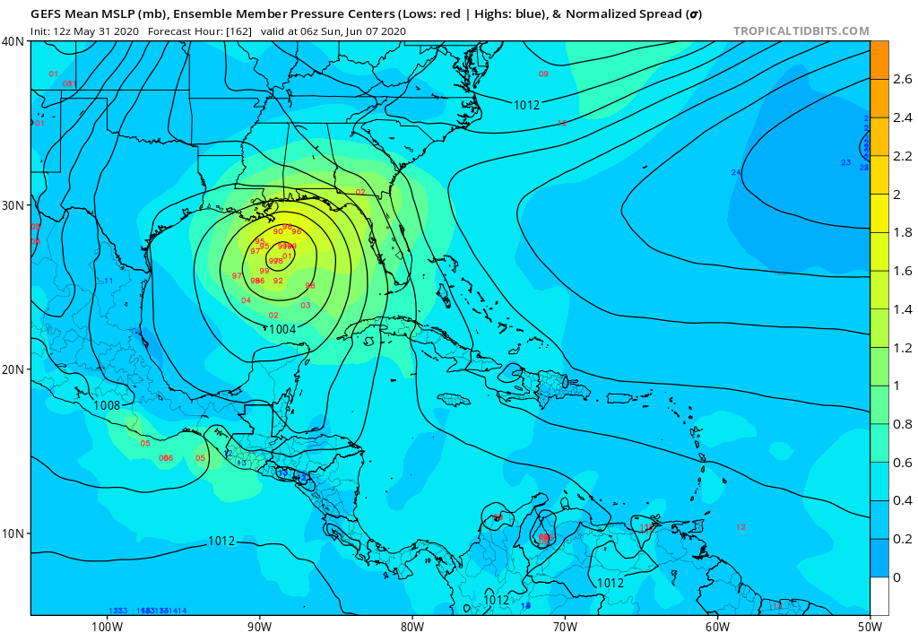
ATL: CRISTOBAL - Models

Moderator: S2k Moderators

Message
Author
User avatar
crownweather
S2K Supporter
S2K Supporter
Posts: 579
Age: 49
Joined: Sat Aug 12, 2006 9:21 am
Location: Sturbridge, Massachusetts
Contact:

Re: ATL: INVEST 93L - Models

#41 Postby crownweather » Sun May 31, 2020 2:25 pm

aspen wrote:
PTrackerLA wrote:12z Euro ensembles coming in even more aggressive. Several members now in the 950mb range targeting TX/LA.

Has there ever been a major hurricane in June? I know Alex ‘10 got really close, with a central pressure just under 950 mbar.


yes, Hurricane Audrey in 1957. Also, Hurricane Alma in 1966.
4 likes   
Rob Lightbown
Crown Weather Services
https://crownweather.com

User avatar
kevin
Category 5
Category 5
Posts: 1799
Age: 25
Joined: Wed Aug 28, 2019 4:35 am

Re: ATL: INVEST 93L - Models

#42 Postby kevin » Sun May 31, 2020 2:29 pm

aspen wrote:
PTrackerLA wrote:12z Euro ensembles coming in even more aggressive. Several members now in the 950mb range targeting TX/LA.

Has there ever been a major hurricane in June? I know Alex ‘10 got really close, with a central pressure just under 950 mbar.


Hurricane Audrey in 1957 is the strongest Atlantic June hurricane and peaked as a category 3 major hurricane (946 mbar) and also made landfall at that intensity. I posted the track of Audrey below. As mentioned in the post above me, Alma also reached category 3 status. There might be others, but those are the only 2 that I can find/think of.

Image
2 likes   

User avatar
Cpv17
Category 5
Category 5
Posts: 4442
Joined: Wed Dec 07, 2016 2:24 pm
Location: Wharton/El Campo, TX

Re: ATL: INVEST 93L - Models

#43 Postby Cpv17 » Sun May 31, 2020 2:45 pm

gatorcane wrote:12Z GFS ensemble mean shifts east:

https://i.postimg.cc/brF1Lrc3/gfs-ememb-lowlocs-watl-28.png


That’s strange because the op had a Galveston landfall and the ensembles aren’t anywhere near there?
0 likes   

stormlover2013
Category 5
Category 5
Posts: 2312
Joined: Thu Aug 22, 2013 12:06 pm
Location: Lumberton, Texas

Re: ATL: INVEST 93L - Models

#44 Postby stormlover2013 » Sun May 31, 2020 3:10 pm

Cpv17 wrote:Well heck, I guess everyone from Mexico to Florida is still in play. Confusing situation.


This isnt going to Florida
1 likes   

User avatar
wxman22
Category 3
Category 3
Posts: 825
Joined: Mon Jan 30, 2006 12:39 am
Location: Houston,Tx
Contact:

Re: ATL: INVEST 93L - Models

#45 Postby wxman22 » Sun May 31, 2020 3:13 pm

Cpv17 wrote:
gatorcane wrote:12Z GFS ensemble mean shifts east:

https://i.postimg.cc/brF1Lrc3/gfs-ememb-lowlocs-watl-28.png


That’s strange because the op had a Galveston landfall and the ensembles aren’t anywhere near there?


That tends to happen quite often especially during the early stages of potential tropical development, where the operational run tends to show a different solution from its ensembles. Sometimes the operational run is more accurate and sometimes the ensembles have a better grasp, time will tell...
1 likes   

User avatar
Kingarabian
S2K Supporter
S2K Supporter
Posts: 15462
Joined: Sat Aug 08, 2009 3:06 am
Location: Honolulu, Hawaii

Re: ATL: INVEST 93L - Models

#46 Postby Kingarabian » Sun May 31, 2020 3:17 pm

We're in range of the 6z/18z Euro runs now.
2 likes   
RIP Kobe Bryant

User avatar
wxman22
Category 3
Category 3
Posts: 825
Joined: Mon Jan 30, 2006 12:39 am
Location: Houston,Tx
Contact:

Re: ATL: INVEST 93L - Models

#47 Postby wxman22 » Sun May 31, 2020 3:18 pm

12z EURO Ensembles

Image
4 likes   

Aric Dunn
Category 5
Category 5
Posts: 21228
Age: 41
Joined: Sun Sep 19, 2004 9:58 pm
Location: Ready for the Chase.
Contact:

Re: ATL: PRE - INVEST 93L - Models

#48 Postby Aric Dunn » Sun May 31, 2020 3:32 pm

the euro ensembles and couple models are showing a wider swing to leftovers of amandda.. . touching the NW carrib before swinging back west. that ultimately slows down the later north motion allowing the upper environment to improve and showing more deepening.
2 likes   
Note: If I make a post that is brief. Please refer back to previous posts for the analysis or reasoning. I do not re-write/qoute what my initial post said each time.
If there is nothing before... then just ask :)

Space & Atmospheric Physicist, Embry-Riddle Aeronautical University,
I believe the sky is falling...

User avatar
aspen
Category 5
Category 5
Posts: 8061
Joined: Sat Oct 12, 2019 7:10 pm
Location: Connecticut, USA

Re: ATL: INVEST 93L - Models

#49 Postby aspen » Sun May 31, 2020 3:39 pm


Seems like just about every member has it stall in the BOC for some time, before looping to the north and intensifying.
0 likes   
Irene '11 Sandy '12 Hermine '16 5/15/2018 Derecho Fay '20 Isaias '20 Elsa '21 Henri '21 Ida '21

I am only a meteorology enthusiast who knows a decent amount about tropical cyclones. Look to the professional mets, the NHC, or your local weather office for the best information.

User avatar
Nimbus
Category 5
Category 5
Posts: 4935
Joined: Mon Jul 19, 2004 10:54 am

Re: ATL: PRE - INVEST 93L - Models

#50 Postby Nimbus » Sun May 31, 2020 3:41 pm

The 93L convection in the BOC is sheared a little NE from the circulating inflow visible in the low level clouds.
Can't say its a closed circulation yet but appears to be drifting NNW.
Amanda is over land so may not stay the dominant feature with much steering potential after tonight.
Buoy 42055 is seeing surface pressure start to drop but that is probably diurnal and the location far enough north that its only be useful to show inflow wind direction.
1 likes   

User avatar
cycloneye
Admin
Admin
Posts: 139722
Age: 67
Joined: Thu Oct 10, 2002 10:54 am
Location: San Juan, Puerto Rico

Re: ATL: PRE - INVEST 93L - Models

#51 Postby cycloneye » Sun May 31, 2020 4:06 pm

The EC ensembles.

Image
3 likes   
Visit the Caribbean-Central America Weather Thread where you can find at first post web cams,radars
and observations from Caribbean basin members Click Here

User avatar
Steve
S2K Supporter
S2K Supporter
Posts: 8611
Joined: Sat Apr 05, 2003 11:41 pm
Location: Not a state-caster

Re: ATL: INVEST 93L - Models

#52 Postby Steve » Sun May 31, 2020 5:03 pm

La Breeze wrote:
Steve wrote:
wxman22 wrote:
There really is no consensus yet, models and there ensembles show anything from the upper Texas coast to southeast Louisiana that's a pretty broad area . It will be a few more days before we have a true consensus as center relocation is likely at this point which will have large impacts on landfall location.


No consensus yet except probably that we will get a storm. Here's where we are now:

ICON - Landfall roughly 168 hours/next Sunday morning in Cameron Parish, LA looks like TS
GFS - Landfall roughly Tuesday morning 6/9 around Chambers County, TX looks like TS
CMC - Landfall roughly at Terrebonne Bay (south of Houma) Saturday night looks like TS
UKMET - Gets to the Center of the Gulf at the end of that US Tropics run

So that's 4 on board with SCLA to SETX. For the mesoscales, NAM 12km is still spinning in the Bay of Campeche at its end in 84 hours.

Which of these tend to be more reliable overall in recent years?


European which wasn’t out then. But a week out, who knows. We haven’t had TVs setup in a while in early June.
0 likes   

User avatar
Kingarabian
S2K Supporter
S2K Supporter
Posts: 15462
Joined: Sat Aug 08, 2009 3:06 am
Location: Honolulu, Hawaii

Re: ATL: PRE - INVEST 93L - Models

#53 Postby Kingarabian » Sun May 31, 2020 5:09 pm

In relations to pre-93L, the 18z GFS has it reforming over the EPAC. It might be 94L or 95L that threatens the CONUS.
0 likes   
RIP Kobe Bryant

User avatar
SoupBone
Category 5
Category 5
Posts: 3073
Joined: Tue Sep 20, 2005 5:24 pm

Re: ATL: INVEST 93L - Models

#54 Postby SoupBone » Sun May 31, 2020 5:19 pm

Aric Dunn wrote:euro initialized the location of Amanda about 12 hours earlier from its current position. and then when it does make it over the BOC it dives it back into mexico and dies then a secondary circ develops to the NE.

if the circ stays over water like the rest of the models then we wont see this.


Won't see what?
0 likes   
Personal Forecast Disclaimer:
The posts in this forum are NOT official forecast and should not be used as such. They are just the opinion of the poster and may or may not be backed by sound meteorological data. They are NOT endorsed by any professional institution or storm2k.org. For official information, please refer to the NHC and NWS products.

User avatar
dixiebreeze
S2K Supporter
S2K Supporter
Posts: 5140
Joined: Wed Sep 03, 2003 5:07 pm
Location: crystal river, fla.

Re: ATL: INVEST 93L - Models

#55 Postby dixiebreeze » Sun May 31, 2020 5:21 pm

stormlover2013 wrote:
Cpv17 wrote:Well heck, I guess everyone from Mexico to Florida is still in play. Confusing situation.


This isnt going to Florida


It will be too close for comfort.
1 likes   

User avatar
Jr0d
S2K Supporter
S2K Supporter
Posts: 1178
Joined: Tue Aug 27, 2019 10:52 am
Location: Cayo Hueso

Re: ATL: PRE - INVEST 93L - Models

#56 Postby Jr0d » Sun May 31, 2020 5:27 pm

I dont think 2 lows developing is out of the realm of possibilities, one in the BoC, the other in the NW Carribean.
Last edited by Jr0d on Sun May 31, 2020 5:55 pm, edited 1 time in total.
1 likes   

User avatar
aspen
Category 5
Category 5
Posts: 8061
Joined: Sat Oct 12, 2019 7:10 pm
Location: Connecticut, USA

Re: ATL: PRE - INVEST 93L - Models

#57 Postby aspen » Sun May 31, 2020 5:38 pm

Kingarabian wrote:In relations to pre-93L, the 18z GFS has it reforming over the EPAC. It might be 94L or 95L that threatens the CONUS.

The GFS has had it reforming over the EPac for days now, and refuses to budge.
0 likes   
Irene '11 Sandy '12 Hermine '16 5/15/2018 Derecho Fay '20 Isaias '20 Elsa '21 Henri '21 Ida '21

I am only a meteorology enthusiast who knows a decent amount about tropical cyclones. Look to the professional mets, the NHC, or your local weather office for the best information.

User avatar
aspen
Category 5
Category 5
Posts: 8061
Joined: Sat Oct 12, 2019 7:10 pm
Location: Connecticut, USA

Re: ATL: PRE - INVEST 93L - Models

#58 Postby aspen » Sun May 31, 2020 6:22 pm

18z ICON has a 974 mbar storm in the middle of the Gulf in 120 hours.
0 likes   
Irene '11 Sandy '12 Hermine '16 5/15/2018 Derecho Fay '20 Isaias '20 Elsa '21 Henri '21 Ida '21

I am only a meteorology enthusiast who knows a decent amount about tropical cyclones. Look to the professional mets, the NHC, or your local weather office for the best information.

User avatar
chaser1
S2K Supporter
S2K Supporter
Posts: 4756
Age: 63
Joined: Sat Oct 15, 2005 5:59 pm
Location: Longwood, Fl

Re: ATL: PRE - INVEST 93L - Models

#59 Postby chaser1 » Sun May 31, 2020 6:58 pm

Jr0d wrote:I dont think 2 lows developing is out of the realm of possibilities, one in the BoC, the other in the NW Carribean.


Two low's? Sure, it could happen especially if one were a fairly tight "spin-up" as the GFS had been projecting for many consecutive model runs until finally dropping the idea several days ago. This seems more plausible if the overall gyre over Central America were to more or less remain in place while the remnants of Amanda and any other lobe of energy might detach and vie for inflow. If the remnants of Amanda were to eventually become organized enough and significantly deepen "in-place", then with enough time it would seem reasonable the gyre would become essentially vertically stacked (albeit a really broad envelope). I think that the models are more or less hinting toward this more coalescent type of evolution. "If" in fact that were to occur then I doubt we'd see other satellite type low's try and spin up. Also, for the moment I don't think there's much if any model support to suggest other development will occur in the Caribbean. The entire mess down there is still pretty fluid so nothing can be entirely counted out.
1 likes   
Personal Forecast Disclaimer:
The posts in this forum are NOT official forecast and should not be used as such. They are just the opinion of the poster and may or may not be backed by sound meteorological data. They are NOT endorsed by any professional institution or storm2k.org. For official information, please refer to the NHC and NWS products.


Aric Dunn
Category 5
Category 5
Posts: 21228
Age: 41
Joined: Sun Sep 19, 2004 9:58 pm
Location: Ready for the Chase.
Contact:

Re: ATL: PRE - INVEST 93L - Models

#60 Postby Aric Dunn » Sun May 31, 2020 7:14 pm

18z Euro now develops a circ in the BOC separate from the remnant of Amanda is 12 to 15 hours. with little to no signs of Amanda's circ being involved at all.
2 likes   
Note: If I make a post that is brief. Please refer back to previous posts for the analysis or reasoning. I do not re-write/qoute what my initial post said each time.
If there is nothing before... then just ask :)

Space & Atmospheric Physicist, Embry-Riddle Aeronautical University,
I believe the sky is falling...


Return to “2020”

Who is online

Users browsing this forum: No registered users and 3 guests