ATL: ISAIAS - Post-Tropical - Discussion

Moderator: S2k Moderators

Message
Author
User avatar
wxman57
Moderator-Pro Met
Moderator-Pro Met
Posts: 23010
Age: 67
Joined: Sat Jun 21, 2003 8:06 pm
Location: Houston, TX (southwest)

Re: ATL: ISAIAS - Hurricane - Discussion

#2761 Postby wxman57 » Fri Jul 31, 2020 7:19 am

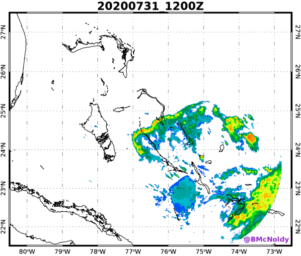
NDG wrote:LLC on the very western edge of the convection, further west than where is supposed to be this morning.
Plenty of west winds for wxman57 to keep him happy :wink:

https://i.imgur.com/JTI0aoK.png


I'm not happy. 12 days without a day off so far. Maybe by next Wednesday. This appears to be a hurricane in name only. Strongest winds aren't even blowing in toward the center. Very poorly organized. As a weaker system, it does have a chance of tracking closer to Florida, though.
6 likes   

cp79

Re: ATL: ISAIAS - Hurricane - Discussion

#2762 Postby cp79 » Fri Jul 31, 2020 7:22 am

BobHarlem wrote:
caneman wrote:
eastcoastFL wrote:Looks like the track shifted a tiny bit west at the end of this loop. It shifts east in the beginning then slightly west, so it appears


http://my.sfwmd.gov/sfwmd/common/images/weather/noaaport/radar_sat_anim.gif


That would be insane. Miami isn’t even in the NHC’s cone!

The more reliable models have it more West touching a landfall. I would expect the NHC to shift closer to landfall in Florida at 11


Wouldn't doubt that now after seeing the 6z Euro is now hitting Miami/S.Fla.
0 likes   

User avatar
drezee
S2K Supporter
S2K Supporter
Posts: 3664
Joined: Mon Jun 09, 2003 12:49 pm
Location: FL

Re: ATL: ISAIAS - Hurricane - Discussion

#2763 Postby drezee » Fri Jul 31, 2020 7:22 am

Going to spit out the LLC at this rate..
0 likes   

Airboy
Category 1
Category 1
Posts: 439
Joined: Wed Jul 27, 2011 10:41 am

Re: ATL: ISAIAS - Hurricane - Discussion

#2764 Postby Airboy » Fri Jul 31, 2020 7:22 am

North of the center:
Peak (10s) Flt. Lvl. Wind: 41 kts (47.2 mph)
SFMR Peak (10s) Sfc. Wind: 63 kts (72.5 mph)
0 likes   
Personal Forecast Disclaimer:
The posts in this forum are NOT official forecast and should not be used as such. They are just the opinion of the poster and may or may not be backed by sound meteorological data. They are NOT endorsed by any professional institution or storm2k.org. For official information, please refer to the NHC and NWS products.

bqknight
Tropical Storm
Tropical Storm
Posts: 107
Joined: Fri Aug 28, 2015 8:47 am
Location: Orlando, FL

Re: ATL: ISAIAS - Hurricane - Discussion

#2765 Postby bqknight » Fri Jul 31, 2020 7:22 am

SIAP but this is a good updating radar loop.

https://bmcnoldy.rsmas.miami.edu/tropic ... ahamas.gif
1 likes   

ava_ati
Tropical Storm
Tropical Storm
Posts: 174
Joined: Thu Sep 01, 2016 8:36 am
Location: Saint Augustine

Re: ATL: ISAIAS - Hurricane - Discussion

#2766 Postby ava_ati » Fri Jul 31, 2020 7:26 am

0 likes   

User avatar
gatorcane
S2K Supporter
S2K Supporter
Posts: 23693
Age: 47
Joined: Sun Mar 13, 2005 3:54 pm
Location: Boca Raton, FL

Re: ATL: ISAIAS - Hurricane - Discussion

#2767 Postby gatorcane » Fri Jul 31, 2020 7:28 am

Given the models shifting west, will hurricane watches go up for South Florida and portions of the Florida east coast?
0 likes   

wx98
Category 5
Category 5
Posts: 1383
Joined: Sat Aug 25, 2018 9:24 pm

Re: ATL: ISAIAS - Hurricane - Discussion

#2768 Postby wx98 » Fri Jul 31, 2020 7:28 am

If this doesn’t get going again fast, they should probably downgrade to a 55-60 kt tropical storm.
3 likes   

User avatar
DestinHurricane
Category 4
Category 4
Posts: 935
Joined: Tue May 01, 2018 8:05 am
Location: New York, NY

Re: ATL: ISAIAS - Hurricane - Discussion

#2769 Postby DestinHurricane » Fri Jul 31, 2020 7:30 am

gatorcane wrote:Given the models shifting west, will hurricane watches go up for South Florida and portions of the Florida east coast?


Doubt it. If it's a hurricane it will stay east. If it goes into Florida it will not be a hurricane. They should upgrade the TS watches to warnings though.
2 likes   
Michael 2018

User avatar
Jevo
S2K Supporter
S2K Supporter
Posts: 1729
Age: 47
Joined: Tue Aug 03, 2004 8:45 pm
Location: The Flemish Cap
Contact:

Re: ATL: ISAIAS - Hurricane - Discussion

#2770 Postby Jevo » Fri Jul 31, 2020 7:30 am

gatorcane wrote:Given the models shifting west, will hurricane watches go up for South Florida and portions of the Florida east coast?


Hit or miss.. this this thing is going to be dealing with so much westerly shear that it can be sitting over Freeport and Boca would have breezy sunny skies.
1 likes   
Disclaimer: 50% of the time I have no clue of what I am talking about. Chances are I am taking a less than educated guess that sounds good because 10 years ago I stole Mike Watkins book 'The Hurricane and its Impact'. For official information please direct yourself to the NHC and their cadre of weather geniuses.

User avatar
tarheelprogrammer
S2K Supporter
S2K Supporter
Posts: 1793
Joined: Mon Mar 28, 2016 9:25 pm
Location: Raleigh, NC area (Garner, NC)

Re: ATL: ISAIAS - Hurricane - Discussion

#2771 Postby tarheelprogrammer » Fri Jul 31, 2020 7:30 am

If a US landfall is going to occur, a weak TS into SFL is not a bad choice. Much better option, as it doesn't have time to get stronger thanks to dry air and shear. Hope it fizzles out before SFL. Best case scenario there.
2 likes   
My posts are not official forecasts. They are just my opinion and may or may not be backed by sound meteorological data. They are NOT endorsed by any professional institution or storm2k.org. For official information, please refer to the NHC and NWS products.

User avatar
DestinHurricane
Category 4
Category 4
Posts: 935
Joined: Tue May 01, 2018 8:05 am
Location: New York, NY

Re: ATL: ISAIAS - Hurricane - Discussion

#2772 Postby DestinHurricane » Fri Jul 31, 2020 7:32 am

Jevo wrote:
gatorcane wrote:Given the models shifting west, will hurricane watches go up for South Florida and portions of the Florida east coast?


Hit or miss.. this this thing is going to be dealing with so much westerly shear that it can be sitting over Freeport and Boca would have breezy sunny skies.

All the convection will be to west so it could be sitting over Boca and Boca have sunny skies with a breeze.
0 likes   
Michael 2018

User avatar
NDG
S2K Supporter
S2K Supporter
Posts: 15463
Joined: Sun Jul 09, 2006 10:14 pm
Location: Orlando, FL

Re: ATL: ISAIAS - Hurricane - Discussion

#2773 Postby NDG » Fri Jul 31, 2020 7:37 am

Incredible flooding going on in the D.R.

 https://twitter.com/LEOVING/status/1289177125757440010


5 likes   

User avatar
Weatherboy1
Category 5
Category 5
Posts: 1189
Age: 49
Joined: Mon Jul 05, 2004 1:50 pm
Location: Jupiter/Sarasota, FL

Re: ATL: ISAIAS - Hurricane - Discussion

#2774 Postby Weatherboy1 » Fri Jul 31, 2020 7:38 am

Kind of a good news/bad news situation here this morning. Good? Isaias getting sheared, which will cap intensification and may have caused some weakening already. Bad? Seems models are shifting back west this morning, which increases the chance of a South FL landfall/grazing by the system. Will be interesting to watch how things go the next several hours. I'm guessing NHC upgrades TS Watch to a Warning for east coast FL at 11 a.m. May add a hurricane watch at 5 p.m. if system can hold together.
3 likes   

AutoPenalti
Category 5
Category 5
Posts: 4059
Age: 29
Joined: Mon Aug 17, 2015 4:16 pm
Location: Ft. Lauderdale, Florida

Re: ATL: ISAIAS - Hurricane - Discussion

#2775 Postby AutoPenalti » Fri Jul 31, 2020 7:41 am

DestinHurricane wrote:
Jevo wrote:
gatorcane wrote:Given the models shifting west, will hurricane watches go up for South Florida and portions of the Florida east coast?


Hit or miss.. this this thing is going to be dealing with so much westerly shear that it can be sitting over Freeport and Boca would have breezy sunny skies.

All the convection will be to west so it could be sitting over Boca and Boca have sunny skies with a breeze.

That’s not how it works.
Last edited by AutoPenalti on Fri Jul 31, 2020 7:43 am, edited 1 time in total.
3 likes   
The posts in this forum are NOT official forecasts and should not be used as such. They are just the opinion of the poster and may or may not be backed by sound meteorological data. They are NOT endorsed by any professional institution or STORM2K. For official information, please refer to products from the NHC and NWS.


Model Runs Cheat Sheet:
GFS (5:30 AM/PM, 11:30 AM/PM)
HWRF, GFDL, UKMET, NAVGEM (6:30-8:00 AM/PM, 12:30-2:00 AM/PM)
ECMWF (1:45 AM/PM)

TCVN
is a weighted averaged

User avatar
DestinHurricane
Category 4
Category 4
Posts: 935
Joined: Tue May 01, 2018 8:05 am
Location: New York, NY

Re: ATL: ISAIAS - Hurricane - Discussion

#2776 Postby DestinHurricane » Fri Jul 31, 2020 7:42 am

AutoPenalti wrote:
DestinHurricane wrote:
Jevo wrote:
Hit or miss.. this this thing is going to be dealing with so much westerly shear that it can be sitting over Freeport and Boca would have breezy sunny skies.

All the convection will be to west so it could be sitting over Boca and Boca have sunny skies with a breeze.

That’s not it works.


It will be a little naked swirl I mean.

Here's a perfect example: https://twitter.com/DaDaBuh/status/1197135282195308544
Last edited by DestinHurricane on Fri Jul 31, 2020 7:43 am, edited 1 time in total.
0 likes   
Michael 2018

User avatar
Evil Jeremy
S2K Supporter
S2K Supporter
Posts: 5463
Age: 32
Joined: Mon Apr 10, 2006 2:10 pm
Location: Los Angeles, CA

Re: ATL: ISAIAS - Hurricane - Discussion

#2777 Postby Evil Jeremy » Fri Jul 31, 2020 7:42 am

TS warnings for SFL (and an extension of the watches further north) at 11am I think is a given this point. Looking at the models, NHC might make the most minor of shifts back West, and wait to see if the 12z guidance solidified that trend.
0 likes   
Frances 04 / Jeanne 04 / Katrina 05 / Wilma 05 / Fay 08 / Debby 12 / Andrea 13 / Colin 16 / Hermine 16 / Matthew 16 / Irma 17

TheStormExpert

Re: ATL: ISAIAS - Hurricane - Discussion

#2778 Postby TheStormExpert » Fri Jul 31, 2020 7:44 am

Here’s the shear that some were doubting would effect Isaias. Not to mention there is SAL out ahead of him over Florida which was mentioned on yesterday afternoon’s Miami NWS Forecast Discussion. Probably not even a hurricane anymore, hopefully won’t ever become one again.
1 likes   

TheStormExpert

Re: ATL: ISAIAS - Hurricane - Discussion

#2779 Postby TheStormExpert » Fri Jul 31, 2020 7:46 am

gatorcane wrote:Given the models shifting west, will hurricane watches go up for South Florida and portions of the Florida east coast?

TS warnings yes, hurricane watches/warnings will greatly depend on if it can maintain or re-intensify. The environment out ahead in The Bahamas must be more hostile than some have thought, even you were mentioning this days ago.
0 likes   

b0tzy29
Tropical Depression
Tropical Depression
Posts: 65
Joined: Sun Sep 02, 2018 9:03 am

Re: ATL: ISAIAS - Hurricane - Discussion

#2780 Postby b0tzy29 » Fri Jul 31, 2020 7:48 am

Quick question for the collective group here - i live on south shore long island on the water. My home and neighborhood were decimated by Sandy. Should i be worried with this one? The models aren't looking to good for southern New England...
Last edited by b0tzy29 on Fri Jul 31, 2020 7:49 am, edited 1 time in total.
1 likes   


Return to “2020”

Who is online

Users browsing this forum: No registered users and 9 guests