CrazyC83 wrote:toad strangler wrote:The calendar doesn't lie. It's do or die time for a CONUS threat and it looks like the latter is at hand.
There have been CONUS hits in November before.
#TWO since 1851 and neither one came from the Caribbean
Moderator: S2k Moderators


CrazyC83 wrote:toad strangler wrote:The calendar doesn't lie. It's do or die time for a CONUS threat and it looks like the latter is at hand.
There have been CONUS hits in November before.

aspen wrote:Levi mentioned in his video last night the possibility of 95L getting caught between two different steering flows and sticking in the WCar for a few days before the ridge arrives. Based on how the system appears to have relocated further SW of the Cayman Islands, that scenario might be becoming ever more likely. It could also be safer from the potential moisture stretching that the GFS shows.

aspen wrote:Levi mentioned in his video last night the possibility of 95L getting caught between two different steering flows and sticking in the WCar for a few days before the ridge arrives. Based on how the system appears to have relocated further SW of the Cayman Islands, that scenario might be becoming ever more likely. It could also be safer from the potential moisture stretching that the GFS shows.

Do_For_Love wrote:aspen wrote:Levi mentioned in his video last night the possibility of 95L getting caught between two different steering flows and sticking in the WCar for a few days before the ridge arrives. Based on how the system appears to have relocated further SW of the Cayman Islands, that scenario might be becoming ever more likely. It could also be safer from the potential moisture stretching that the GFS shows.
Sounds pretty dangerous. I think I remember him mentioning some potential problems for proto-zeta with dry air from the western gulf if it tracks that way, though. Hopefully that's true, let's give the region a break, lol...


toad strangler wrote:The calendar doesn't lie. It's do or die time for a CONUS threat and it looks like the latter is at hand.
SFLcane wrote:aspen wrote:Levi mentioned in his video last night the possibility of 95L getting caught between two different steering flows and sticking in the WCar for a few days before the ridge arrives. Based on how the system appears to have relocated further SW of the Cayman Islands, that scenario might be becoming ever more likely. It could also be safer from the potential moisture stretching that the GFS shows.
This is exactly what is happening in my opinion atleast with a relocation further SW was all that was needed to give the ridge sometime to build. At this point the longer it sits down there the Yucatán might have to watch as any north motion will essentially be blocked. Other then that I feel for gulfcoast residents what a season for them.

Hypercane_Kyle wrote:toad strangler wrote:The calendar doesn't lie. It's do or die time for a CONUS threat and it looks like the latter is at hand.
You underestimate this season's irrational hatred for Louisiana.
toad strangler wrote:CrazyC83 wrote:toad strangler wrote:The calendar doesn't lie. It's do or die time for a CONUS threat and it looks like the latter is at hand.
There have been CONUS hits in November before.
#TWO since 1851 and neither one came from the Caribbean

aspen wrote:The circulation is still broad on visible satellite imagery (I can see westward moving cirrus clouds as north as the Cuban coast), but all of that <-75C convection firing further south should tighten up the circulation there.

caneman wrote:toad strangler wrote:CrazyC83 wrote:
There have been CONUS hits in November before.
#TWO since 1851 and neither one came from the Caribbean
Have you not learned anything from 2020? Further, climo is just a guide, it doesn't predict the future. At some point there would be a 3rd storm.
Blown Away wrote:Drifting SW?

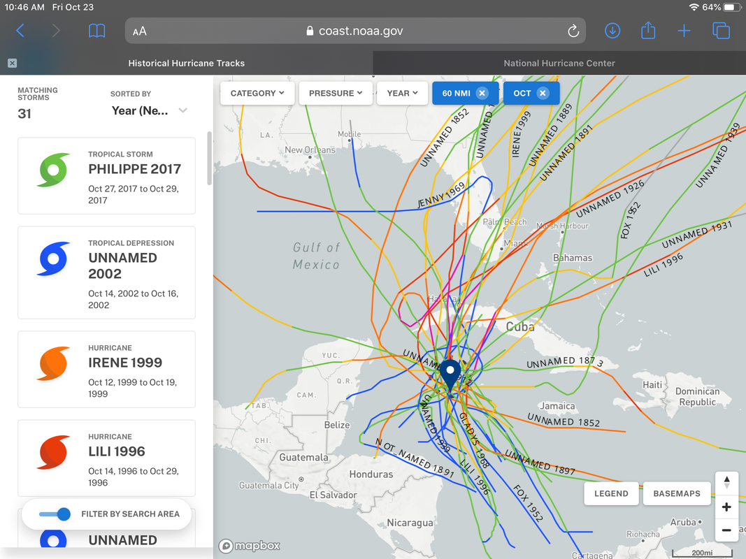
gatorcane wrote:That track by the Euro is highly unusual if you look at climo. I couldn’t find one storm that took that track in late October in 150 years of historical tracks.
Historical tracks. All of the ones that impacted the northern and western Gulf were in early or mid October.
Image courtesy of:
https://oceanservice.noaa.gov/news/hist ... urricanes/
https://i.postimg.cc/yNWvHwjg/8-FD572-B9-D663-444-A-967-B-CB01-C9-E1-F685.png
Weatherboy1 wrote:gatorcane wrote:That track by the Euro is highly unusual if you look at climo. I couldn’t find one storm that took that track in late October in 150 years of historical tracks.
Historical tracks. All of the ones that impacted the northern and western Gulf were in early or mid October.
Image courtesy of:
https://oceanservice.noaa.gov/news/hist ... urricanes/
https://i.postimg.cc/yNWvHwjg/8-FD572-B9-D663-444-A-967-B-CB01-C9-E1-F685.png
To use one of my favorite expressions, I would bet dollars to donuts this never makes landfall further west than Panama City Beach area or so ... and that models will shift East to
Reflect that in next couple cycles. Climo isn’t everything but This time of year it’s far more likely that a system in this area will get swept NNE or NE. Irene classic case where models were too far west over and over

Users browsing this forum: No registered users and 51 guests


