ATL: ETA - Post-Tropical - Discussion

Moderator: S2k Moderators

Message
Author
User avatar
Blown Away
S2K Supporter
S2K Supporter
Posts: 10157
Joined: Wed May 26, 2004 6:17 am

Re: ATL: ETA - Hurricane - Discussion

#2461 Postby Blown Away » Tue Nov 03, 2020 4:35 pm

TheStormExpert wrote:
Blown Away wrote:


Some good news they didn't get the Cat 5 monster we thought would happen... The rain, ugh...

Instead they got a Cat.4 monster. :eek:


The tweet implied Cat 2-3 winds and center was just S... That community hopefully missed the core...
0 likes   
Hurricane Eye Experience: David 79, Irene 99, Frances 04, Jeanne 04, Wilma 05… Hurricane Brush Experience: Andrew 92, Erin 95, Floyd 99, Matthew 16, Irma 17, Ian 22, Nicole 22…

jlauderdal
S2K Supporter
S2K Supporter
Posts: 7186
Joined: Wed May 19, 2004 5:46 am
Location: NE Fort Lauderdale
Contact:

Re: RE: Re: ATL: ETA - Hurricane - Discussion

#2462 Postby jlauderdal » Tue Nov 03, 2020 4:39 pm

Blown Away wrote:Image
Image
King may be the best analog for Eta. VortexFl posted links.
Miami nws very aggressive with rainfall totals...cant recall 15 inches mentioned in any disco
2 likes   

User avatar
Blown Away
S2K Supporter
S2K Supporter
Posts: 10157
Joined: Wed May 26, 2004 6:17 am

Re: RE: Re: ATL: ETA - Hurricane - Discussion

#2463 Postby Blown Away » Tue Nov 03, 2020 4:46 pm

jlauderdal wrote:
Blown Away wrote:https://i.imgur.com/0GrJ7yX.jpg
https://i.imgur.com/8pILmfg.jpg
King may be the best analog for Eta. VortexFl posted links.
Miami nws very aggressive with rainfall totals...cant recall 15 inches mentioned in any disco

Snipet from NWS Miami 3:28 Disco: Thursday Through this weekend...
All eyes turn to the strength and path of tropical cyclone Eta
currently located near Nicaragua. The latest long range models are
showing the system to move northeast into somewhere in the NW
Caribbean Sea late this week into this upcoming weekend. At the
same time, a ridge of high pressure over the southeast United
States will move east into the Atlantic waters as a trough of low
pressure develop over the Gulf of mexico and moves northeast into
the Florida Peninsula. This will allow for a tightening pressure
gradient over South Florida late this week into this weekend and
allow for very deep tropical moisture to work into the region from
the Caribbean Sea. Therefore, breezy to windy easterly flow will
develop over South Florida late this week into this weekend along
with scattered to numerous showers and thunderstorms especially
over the east coast metro areas.
0 likes   
Hurricane Eye Experience: David 79, Irene 99, Frances 04, Jeanne 04, Wilma 05… Hurricane Brush Experience: Andrew 92, Erin 95, Floyd 99, Matthew 16, Irma 17, Ian 22, Nicole 22…

User avatar
SFLcane
S2K Supporter
S2K Supporter
Posts: 10163
Age: 47
Joined: Sat Jun 05, 2010 1:44 pm
Location: Lake Worth Florida

Re: RE: Re: ATL: ETA - Hurricane - Discussion

#2464 Postby SFLcane » Tue Nov 03, 2020 4:48 pm

jlauderdal wrote:
Blown Away wrote:https://i.imgur.com/0GrJ7yX.jpg
https://i.imgur.com/8pILmfg.jpg
King may be the best analog for Eta. VortexFl posted links.
Miami nws very aggressive with rainfall totals...cant recall 15 inches mentioned in any disco


We’re is the disco calling for 15 inches?
0 likes   

VortexFl
Tropical Wave
Tropical Wave
Posts: 7
Joined: Sun Nov 01, 2020 4:57 am

Re: ATL: ETA - Hurricane - Discussion

#2465 Postby VortexFl » Tue Nov 03, 2020 4:50 pm

"East Coast 7-10" of rain localized amounts up to 15"


.Hydrology...
The long range models are also showing that the PWAT values will
be in the 2.1 to 2.4 inches range which is at the maximum value
for the PWAT values for this time of Year. This means that any
showers and thunderstorms that do develop will be capable of
producing heavy rainfall this weekend. Weather Prediction Center
(WPC) is also forecasting at this time around 3 to 5 inches for
the west coast metro areas to 7 to 10 inches for the east coast
metro areas with isolated amounts up to 15 inches mainly between
Friday early next week. Will continue to monitor the the forecast
model runs on the potential of heavy rainfall for South Florida
this weekend, and if trends continue then a Flood Watch may be
needed late this week for this weekend.
0 likes
3 likes   

User avatar
cheezyWXguy
Category 5
Category 5
Posts: 6108
Joined: Mon Feb 13, 2006 12:29 am
Location: Dallas, TX

Re: ATL: ETA - Hurricane - Discussion

#2466 Postby cheezyWXguy » Tue Nov 03, 2020 4:56 pm

It is still beyond me how last night’s near perfect presentation equated to 150mph when the current landfall presentation yields 140mph. It’s not like the pressure gradient was flattening out. Despite hints at a double wind maximum, it wasn’t very prominent at all, and hurricane force winds only extended about 25mi from the center.
3 likes   

User avatar
SFLcane
S2K Supporter
S2K Supporter
Posts: 10163
Age: 47
Joined: Sat Jun 05, 2010 1:44 pm
Location: Lake Worth Florida

Re: ATL: ETA - Hurricane - Discussion

#2467 Postby SFLcane » Tue Nov 03, 2020 4:57 pm

Wow! Going to need a bigger boat :eek:

This is Irene 99 type potential

Image
4 likes   

User avatar
Iceresistance
Category 5
Category 5
Posts: 9290
Age: 21
Joined: Sat Oct 10, 2020 9:45 am
Location: Tecumseh, OK/Norman, OK

Re: ATL: ETA - Hurricane - Discussion

#2468 Postby Iceresistance » Tue Nov 03, 2020 5:01 pm

SFLcane wrote:Wow! Going to need a bigger boat :eek:

This is Irene 99 type potential

https://i.postimg.cc/3JXDjSVm/637-D313-E-80-D1-4706-933-E-E27-B1448-DCD5.jpg

How strong will Eta be at the Florida landfall?
0 likes   
Bill 2015 & Beta 2020

Winter 2020-2021 :cold:

All observations are in Tecumseh, OK unless otherwise noted.

Winter posts are focused mainly for Oklahoma & Texas.

Take any of my forecasts with a grain of salt, refer to the NWS, SPC, and NHC for official information

Never say Never with weather! Because ANYTHING is possible!

User avatar
wxman57
Moderator-Pro Met
Moderator-Pro Met
Posts: 22987
Age: 67
Joined: Sat Jun 21, 2003 8:06 pm
Location: Houston, TX (southwest)

Re: ATL: ETA - Hurricane - Discussion

#2469 Postby wxman57 » Tue Nov 03, 2020 5:02 pm

I should stress that we don't know how Eta will be structured if and when it redevelops in the Caribbean this weekend, or how crossing Cuba may affect it. I'd say that the FL Peninsula could anticipate 5-10 inches of rain from Sunday through Tuesday, but that's just a guess this far out. We may not really be confident in potential rainfall totals across Florida until late Saturday, once we see what is in the western Caribbean.
11 likes   

User avatar
SouthFLTropics
Category 5
Category 5
Posts: 4238
Age: 50
Joined: Thu Aug 14, 2003 8:04 am
Location: Port St. Lucie, Florida

Re: ATL: ETA - Hurricane - Discussion

#2470 Postby SouthFLTropics » Tue Nov 03, 2020 5:03 pm

Iceresistance wrote:
SFLcane wrote:Wow! Going to need a bigger boat :eek:

This is Irene 99 type potential

https://i.postimg.cc/3JXDjSVm/637-D313-E-80-D1-4706-933-E-E27-B1448-DCD5.jpg

How strong will Eta be at the Florida landfall?


That's a 10 million dollar question that can't be known at this time.
1 likes   
Fourth Generation Florida Native

Personal Storm History: David 79, Andrew 92, Erin 95, Floyd 99, Irene 99, Frances 04, Jeanne 04, Wilma 05, Matthew 16, Irma 17, Ian 22, Nicole 22, Milton 24

User avatar
Iceresistance
Category 5
Category 5
Posts: 9290
Age: 21
Joined: Sat Oct 10, 2020 9:45 am
Location: Tecumseh, OK/Norman, OK

Re: ATL: ETA - Hurricane - Discussion

#2471 Postby Iceresistance » Tue Nov 03, 2020 5:03 pm

wxman57 wrote:I should stress that we don't know how Eta will be structured if and when it redevelops in the Caribbean this weekend, or how crossing Cuba may affect it. I'd say that the FL Peninsula could anticipate 5-10 inches of rain from Sunday through Tuesday, but that's just a guess this far out. We may not really be confident in potential rainfall totals across Florida until late Saturday, once we see what is in the western Caribbean.

Eta is going to be very hard to forecast. . .
0 likes   
Bill 2015 & Beta 2020

Winter 2020-2021 :cold:

All observations are in Tecumseh, OK unless otherwise noted.

Winter posts are focused mainly for Oklahoma & Texas.

Take any of my forecasts with a grain of salt, refer to the NWS, SPC, and NHC for official information

Never say Never with weather! Because ANYTHING is possible!

User avatar
Iceresistance
Category 5
Category 5
Posts: 9290
Age: 21
Joined: Sat Oct 10, 2020 9:45 am
Location: Tecumseh, OK/Norman, OK

Re: ATL: ETA - Hurricane - Discussion

#2472 Postby Iceresistance » Tue Nov 03, 2020 5:04 pm

SouthFLTropics wrote:
Iceresistance wrote:
SFLcane wrote:Wow! Going to need a bigger boat :eek:

This is Irene 99 type potential

https://i.postimg.cc/3JXDjSVm/637-D313-E-80-D1-4706-933-E-E27-B1448-DCD5.jpg

How strong will Eta be at the Florida landfall?


That's a 10 million dollar question that can't be known at this time.

I forgot to say 'according to the model?' :P
0 likes   
Bill 2015 & Beta 2020

Winter 2020-2021 :cold:

All observations are in Tecumseh, OK unless otherwise noted.

Winter posts are focused mainly for Oklahoma & Texas.

Take any of my forecasts with a grain of salt, refer to the NWS, SPC, and NHC for official information

Never say Never with weather! Because ANYTHING is possible!

User avatar
Jr0d
S2K Supporter
S2K Supporter
Posts: 1410
Joined: Tue Aug 27, 2019 10:52 am
Location: Cayo Hueso

Re: ATL: ETA - Hurricane - Discussion

#2473 Postby Jr0d » Tue Nov 03, 2020 5:07 pm

SFLcane wrote:Wow! Going to need a bigger boat :eek:

This is Irene 99 type potential

https://i.postimg.cc/3JXDjSVm/637-D313-E-80-D1-4706-933-E-E27-B1448-DCD5.jpg


I know a lot of folks here in the Keys feel safe because of Cuba possibly weakening the storm before its near us. This was not the case with Irene of '99.

As the experts are saying...trying to guess intensity right now is tough. Until it re-emerges we will not know what to expect or what the structure will be.

I do think the overall size of the storm will be larger but that does not necessarily mean a stronger storm.
2 likes   

underthwx
Category 5
Category 5
Posts: 2363
Joined: Sat Jul 30, 2011 2:14 pm
Location: Brazoria County Texas

Re: ATL: ETA - Hurricane - Discussion

#2474 Postby underthwx » Tue Nov 03, 2020 5:26 pm

SouthFLTropics wrote:
Iceresistance wrote:

How strong will Eta be at the Florida landfall?


That's a 10 million dollar question that can't be known at
this time.


Kind of like predicting the winner of an election...
Last edited by underthwx on Tue Nov 03, 2020 5:32 pm, edited 1 time in total.
1 likes   

User avatar
MetroMike
Category 4
Category 4
Posts: 952
Joined: Sun Aug 29, 2004 8:13 pm
Location: Tampa Bay
Contact:

Re: ATL: ETA - Hurricane - Discussion

#2475 Postby MetroMike » Tue Nov 03, 2020 5:29 pm

wxman57 wrote:I should stress that we don't know how Eta will be structured if and when it redevelops in the Caribbean this weekend, or how crossing Cuba may affect it. I'd say that the FL Peninsula could anticipate 5-10 inches of rain from Sunday through Tuesday, but that's just a guess this far out. We may not really be confident in potential rainfall totals across Florida until late Saturday, once we see what is in the western Caribbean.


That is correct, Precip forecasts are subject to large errors more than a couple days out.
Not an exact science as variables abound.
0 likes   

Ken711
Category 5
Category 5
Posts: 1074
Joined: Tue Aug 28, 2012 12:48 pm

Re: ATL: ETA - Hurricane - Discussion

#2476 Postby Ken711 » Tue Nov 03, 2020 5:42 pm

What is the terrain like in Cuba for the forecasted NHC track?
0 likes   

User avatar
AJC3
Admin
Admin
Posts: 4002
Age: 61
Joined: Tue Aug 31, 2004 7:04 pm
Location: Ballston Spa, New York
Contact:

Re: ATL: ETA - Hurricane - Discussion

#2477 Postby AJC3 » Tue Nov 03, 2020 5:44 pm

Blown Away wrote:https://i.imgur.com/0GrJ7yX.jpg
https://i.imgur.com/8pILmfg.jpg
King may be the best analog for Eta. VortexFl posted links.


I was just about to post something along this line. The synoptic setup is pretty much textbook for a N-NW "slingshot" into Florida. Cutoff low over the GOMEX shears out into a negative tilt trough, with a strong blocking ridge over the western Atlantic and eastern U.S. coast. It's hard for me to envision this *not* having a significant impact on Florida.
7 likes   

User avatar
got ants?
Tropical Storm
Tropical Storm
Posts: 114
Age: 66
Joined: Sat Sep 03, 2011 3:44 am
Location: Hollywood/Ft Laud

Re: ATL: ETA - Hurricane - Discussion

#2478 Postby got ants? » Tue Nov 03, 2020 5:52 pm

Haven't been watching this closely the past few days (my brother passed away saturday).. but if it does vomes this way we are in trouble.

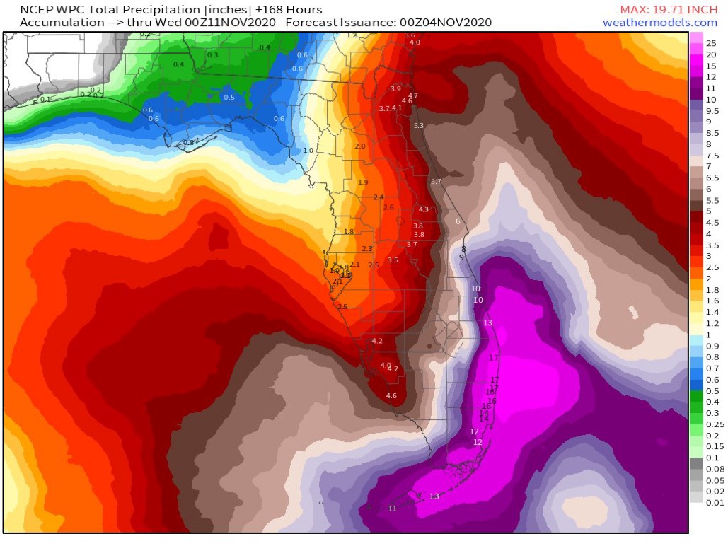
Its rained every single day in October which very unusual. My backyard had water 4" sitting for a week. It caused my septic to back up/over flow. No trick or treaters as our streets were flooded. Saturday alone we had anout 10" of rain.

While the water has finally resided, more rain within a week will have some areas flooding, water inside houses. All bodies of water are full, lakes/ponds, etc..

Just more of 2020, I huess... :eek:
1 likes   
This post is NOT AN OFFICIAL FORECAST and should not be used as such. It is just the opinion of the poster and may or may not be backed by sound meteorological data. It is NOT endorsed by any professional institution including storm2k.org. For Official Information please refer to the NHC and NWS products.

User avatar
SFLcane
S2K Supporter
S2K Supporter
Posts: 10163
Age: 47
Joined: Sat Jun 05, 2010 1:44 pm
Location: Lake Worth Florida

Re: ATL: ETA - Hurricane - Discussion

#2479 Postby SFLcane » Tue Nov 03, 2020 6:13 pm

AJC3 wrote:
Blown Away wrote:https://i.imgur.com/0GrJ7yX.jpg
https://i.imgur.com/8pILmfg.jpg
King may be the best analog for Eta. VortexFl posted links.


I was just about to post something along this line. The synoptic setup is pretty much textbook for a N-NW "slingshot" into Florida. Cutoff low over the GOMEX shears out into a negative tilt trough, with a strong blocking ridge over the western Atlantic and eastern U.S. coast. It's hard for me to envision this *not* having a significant impact on Florida.


:eek:
2 likes   

User avatar
chaser1
S2K Supporter
S2K Supporter
Posts: 5493
Age: 64
Joined: Sat Oct 15, 2005 5:59 pm
Location: Longwood, Fl

Re: ATL: ETA - Hurricane - Discussion

#2480 Postby chaser1 » Tue Nov 03, 2020 6:38 pm

AJC3 wrote:
Blown Away wrote:https://i.imgur.com/0GrJ7yX.jpg
https://i.imgur.com/8pILmfg.jpg
King may be the best analog for Eta. VortexFl posted links.


I was just about to post something along this line. The synoptic setup is pretty much textbook for a N-NW "slingshot" into Florida. Cutoff low over the GOMEX shears out into a negative tilt trough, with a strong blocking ridge over the western Atlantic and eastern U.S. coast. It's hard for me to envision this *not* having a significant impact on Florida.


Agreed. I think a reasonable wind event would range anywhere from a weak T.S to a Cat 1 hurricane. The biggest key however may be unlike King '50 where that storm took a pretty straight path right up the spine of Florida. If next week verifies, I'd think it could be a broader "nuisance" wind event possibly impacting many more people over a larger area. Precip impact might be tremendous if the system stalls or tracks erratically, or actually pulls off a hat-trick Florida landfall (Keys or S. Fla, then bend west over Central Fla. into the GOM, then north or NE over the Big Bend. Like always, timing will impact intensity and track. I'm thinking perhaps some blended average between the operational GFS-Para and Euro for ultimate track & timing, and the HWRF for plausible intensity.
3 likes   
Andy D

(For official information, please refer to the NHC and NWS products.)


Return to “2020”

Who is online

Users browsing this forum: No registered users and 20 guests