https://twitter.com/BMcNoldy/status/1319945437365714944
ATL: ZETA - Post-Tropical - Discussion
Moderator: S2k Moderators
-
cycloneye

- Admin

- Posts: 149843
- Age: 69
- Joined: Thu Oct 10, 2002 10:54 am
- Location: San Juan, Puerto Rico
Re: ATL: INVEST 95L - Discussion
0 likes
Visit the Caribbean-Central America Weather Thread where you can find at first post web cams,radars
and observations from Caribbean basin members Click Here
and observations from Caribbean basin members Click Here

Re: ATL: INVEST 95L - Discussion
cycloneye wrote:https://twitter.com/BMcNoldy/status/1319945437365714944
Good morning CE....those are some nice radars...thanks for sharing
0 likes

Re: ATL: INVEST 95L - Discussion
SouthFLTropics wrote:Looking at the new convection firing I would guess that the COC is now directly well South of Grand Cayman. Until this finishes consolidating, I think we should be suspect of any model tracks or intensities.
Blob watching and there is at least mid level spin further SSW than models initialized.
LLC may have chased the convection in under that and a trough has less effect on a system further south.
Key to the big picture may be the speed of the forecast.
The trough is expected to give way to a high locating east of Florida.
Classic late season storms affecting Florida require a gentle low shear flow around a high in that location to strengthen.
Levi explained the early model run frames that showed the gulf still under light shear with dry air from the passage of the trough(might even dig and stall).
If there is a delay and Zeta takes more time strengthening in the Caribbean that would give more time for the classic high set up east of Florida.
2 likes
Re: ATL: INVEST 95L - Discussion
TheStormExpert wrote:Looks like scrambled eggs this morning.
Lol....up till I read your post....I have been struggling with what to have for breakfast...thanks!...
2 likes
-
cycloneye
- Admin
- Posts: 149843
- Age: 69
- Joined: Thu Oct 10, 2002 10:54 am
- Location: San Juan, Puerto Rico
Re: ATL: INVEST 95L - Discussion
Tropical Weather Outlook
NWS National Hurricane Center Miami FL
800 AM EDT Sat Oct 24 2020
For the North Atlantic...Caribbean Sea and the Gulf of Mexico:
The National Hurricane Center is issuing advisories on Hurricane
Epsilon, located over the west-central Atlantic Ocean.
Satellite, radar and surface data indicate that a broad area of low
pressure located just southwest of Grand Cayman Island is gradually
becoming better organized, with a better defined wind circulation,
increasing thunderstorm activity and falling surface pressures since
yesterday. Environmental conditions are conducive for further
development, and a tropical depression is expected to form within
the next day or so while the low drifts toward the north and
northwest. The system could move near western Cuba on Monday and
move slowly across the southeastern Gulf of Mexico by Tuesday.
Interests in western Cuba, the Florida Keys, and the Yucatan
Peninsula should monitor the progress of this disturbance. A NOAA
Hurricane Hunter reconnaissance aircraft is scheduled to investigate
the disturbance this afternoon. Regardless of development, locally
heavy rainfall will be possible over portions of the Cayman Islands,
Jamaica and Cuba through early next week.
* Formation chance through 48 hours...high...90 percent.
* Formation chance through 5 days...high...90 percent.
$$
Forecaster Blake
0 likes
Visit the Caribbean-Central America Weather Thread where you can find at first post web cams,radars
and observations from Caribbean basin members Click Here
and observations from Caribbean basin members Click Here

Re: ATL: INVEST 95L - Discussion
cycloneye wrote:Tropical Weather Outlook
NWS National Hurricane Center Miami FL
800 AM EDT Sat Oct 24 2020
For the North Atlantic...Caribbean Sea and the Gulf of Mexico:
The National Hurricane Center is issuing advisories on Hurricane
Epsilon, located over the west-central Atlantic Ocean.
Satellite, radar and surface data indicate that a broad area of low
pressure located just southwest of Grand Cayman Island is gradually
becoming better organized, with a better defined wind circulation,
increasing thunderstorm activity and falling surface pressures since
yesterday. Environmental conditions are conducive for further
development, and a tropical depression is expected to form within
the next day or so while the low drifts toward the north and
northwest. The system could move near western Cuba on Monday and
move slowly across the southeastern Gulf of Mexico by Tuesday.
Interests in western Cuba, the Florida Keys, and the Yucatan
Peninsula should monitor the progress of this disturbance. A NOAA
Hurricane Hunter reconnaissance aircraft is scheduled to investigate
the disturbance this afternoon. Regardless of development, locally
heavy rainfall will be possible over portions of the Cayman Islands,
Jamaica and Cuba through early next week.
* Formation chance through 48 hours...high...90 percent.
* Formation chance through 5 days...high...90 percent.
$$
Forecaster Blake
90/90 with a recon plane scheduled to investigate and even the Euro showing development...we’ll likely say hello to Zeta by the end of the day.
2 likes
Irene '11 Sandy '12 Hermine '16 5/15/2018 Derecho Fay '20 Isaias '20 Elsa '21 Henri '21 Ida '21
I am only a meteorology enthusiast who knows a decent amount about tropical cyclones. Look to the professional mets, the NHC, or your local weather office for the best information.
I am only a meteorology enthusiast who knows a decent amount about tropical cyclones. Look to the professional mets, the NHC, or your local weather office for the best information.

-
SFLcane

- S2K Supporter

- Posts: 10281
- Age: 48
- Joined: Sat Jun 05, 2010 1:44 pm
- Location: Lake Worth Florida
Re: ATL: INVEST 95L - Discussion
South Florida dodges yet another one. Works for me. Weekend might not be so rainy after all as it seems 95L will move far enough to the west.
1 likes
-
Blown Away

- S2K Supporter
- Posts: 10253
- Joined: Wed May 26, 2004 6:17 am
Re: ATL: INVEST 95L - Discussion
SFLcane wrote:South Florida dodges yet another one. Works for me. Weekend might not be so rainy after all as it seems 95L will move far enough to the west.
A stationary late October NW Caribbean storm, no way they know where this is going with high confidence. Just 24 hours ago it was supposed to go ENE under FL into the Bahamas. Huge model track swings are very common this time of year.
5 likes
Hurricane Eye Experience: David 79, Irene 99, Frances 04, Jeanne 04, Wilma 05… Hurricane Brush Experience: Andrew 92, Erin 95, Floyd 99, Matthew 16, Irma 17, Ian 22, Nicole 22…
Re: ATL: INVEST 95L - Discussion
Blown Away wrote:SFLcane wrote:South Florida dodges yet another one. Works for me. Weekend might not be so rainy after all as it seems 95L will move far enough to the west.
A stationary late October NW Caribbean storm, no way they know where this is going with high confidence. Just 24 hours ago it was supposed to go ENE under FL into the Bahamas. Huge model track swings are very common this time of year.
Indeed, while things do look better for SFL compared to yesterday there is still so much wiggle room and I'd be surprised if the current predicted path is exactly the one it will actually take. While the extreme ends of the spectrum in terms of track are course less likely, anything from a Bahamas track to a track into Central America is still on the table imo. I do think we'll know more later today, especially when data from the recon gets feeded into the models.
Last edited by kevin on Sat Oct 24, 2020 7:08 am, edited 3 times in total.
3 likes
-
SFLcane
- S2K Supporter
- Posts: 10281
- Age: 48
- Joined: Sat Jun 05, 2010 1:44 pm
- Location: Lake Worth Florida
Re: ATL: INVEST 95L - Discussion
Blown Away wrote:SFLcane wrote:South Florida dodges yet another one. Works for me. Weekend might not be so rainy after all as it seems 95L will move far enough to the west.
A stationary late October NW Caribbean storm, no way they know where this is going with high confidence. Just 24 hours ago it was supposed to go ENE under FL into the Bahamas. Huge model track swings are very common this time of year.
High pressure should protect SFL. Note we are not even mentioned in the TWO as of 8am just the keys. Development cone also shifted way west. With the euro ensembles more aggressive joining the rest of the guidance heading for the gulfcoast I feel pretty good. Lucky times continue for SFL.
0 likes
Re: ATL: INVEST 95L - Discussion
kevin wrote:Blown Away wrote:SFLcane wrote:South Florida dodges yet another one. Works for me. Weekend might not be so rainy after all as it seems 95L will move far enough to the west.
A stationary late October NW Caribbean storm, no way they know where this is going with high confidence. Just 24 hours ago it was supposed to go ENE under FL into the Bahamas. Huge model track swings are very common this time of year.
Indeed, while things do look better for SFL compared to yesterday there is still so much wiggle room and I'd be surprised if the current predicted path is exactly the one it will actually take. While the extreme ends of the spectrum in terms of track are course less likely, anything from a Bahamas track to a track into Central America is still on the table imo. I do think we'll know more later today, especially when data from the recon gets feeded into the models.
I agree with you...there may be another reformation of the center, maybe more than one?....I look forward to recon providing some data...
2 likes
Re: ATL: INVEST 95L - Discussion
This might be worthy of a PTC designation by now.
0 likes
Irene '11 Sandy '12 Hermine '16 5/15/2018 Derecho Fay '20 Isaias '20 Elsa '21 Henri '21 Ida '21
I am only a meteorology enthusiast who knows a decent amount about tropical cyclones. Look to the professional mets, the NHC, or your local weather office for the best information.
I am only a meteorology enthusiast who knows a decent amount about tropical cyclones. Look to the professional mets, the NHC, or your local weather office for the best information.
-
gatorcane

- S2K Supporter
- Posts: 23708
- Age: 48
- Joined: Sun Mar 13, 2005 3:54 pm
- Location: Boca Raton, FL
Re: ATL: INVEST 95L - Discussion
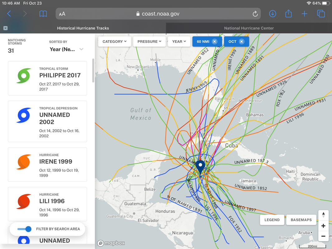
That track by the Euro is highly unusual if you look at climo. I couldn’t find one storm that took that track in late October in 150 years of historical tracks.
Historical tracks. All of the ones that impacted the northern and western Gulf were in early or mid October.
Image courtesy of:
https://oceanservice.noaa.gov/news/hist ... urricanes/
Historical tracks. All of the ones that impacted the northern and western Gulf were in early or mid October.
Image courtesy of:
https://oceanservice.noaa.gov/news/hist ... urricanes/
2 likes
-
SFLcane
- S2K Supporter
- Posts: 10281
- Age: 48
- Joined: Sat Jun 05, 2010 1:44 pm
- Location: Lake Worth Florida
Re: ATL: INVEST 95L - Discussion
gatorcane wrote:That track by the Euro is highly unusual if you look at climo. I couldn’t find one storm that took that track in late October in 150 years of historical tracks.
Historical tracks. All of the ones that impacted the northern and western Gulf were in early or mid October.
Image courtesy of:
https://oceanservice.noaa.gov/news/hist ... urricanes/
https://i.postimg.cc/yNWvHwjg/8-FD572-B9-D663-444-A-967-B-CB01-C9-E1-F685.png
Gatorcane, 2020 is the year of highly unusual.
Last edited by SFLcane on Sat Oct 24, 2020 7:29 am, edited 1 time in total.
6 likes
-
Blown Away
- S2K Supporter
- Posts: 10253
- Joined: Wed May 26, 2004 6:17 am
Re: ATL: INVEST 95L - Discussion
gatorcane wrote:That track by the Euro is highly unusual if you look at climo. I couldn’t find one storm that took that track in late October in 150 years of historical tracks.
Historical tracks. All of the ones that impacted the northern and western Gulf were in early or mid October.
Image courtesy of:
https://oceanservice.noaa.gov/news/hist ... urricanes/
https://i.postimg.cc/yNWvHwjg/8-FD572-B9-D663-444-A-967-B-CB01-C9-E1-F685.png
I agree, climo heavily favors not CGOM coast, but so many storms past few years going against climo it’s hard to disregard.
0 likes
Hurricane Eye Experience: David 79, Irene 99, Frances 04, Jeanne 04, Wilma 05… Hurricane Brush Experience: Andrew 92, Erin 95, Floyd 99, Matthew 16, Irma 17, Ian 22, Nicole 22…
Re: ATL: INVEST 95L - Discussion
Levi mentioned in his video last night the possibility of 95L getting caught between two different steering flows and sticking in the WCar for a few days before the ridge arrives. Based on how the system appears to have relocated further SW of the Cayman Islands, that scenario might be becoming ever more likely. It could also be safer from the potential moisture stretching that the GFS shows.
2 likes
Irene '11 Sandy '12 Hermine '16 5/15/2018 Derecho Fay '20 Isaias '20 Elsa '21 Henri '21 Ida '21
I am only a meteorology enthusiast who knows a decent amount about tropical cyclones. Look to the professional mets, the NHC, or your local weather office for the best information.
I am only a meteorology enthusiast who knows a decent amount about tropical cyclones. Look to the professional mets, the NHC, or your local weather office for the best information.
-
Loveweather12
- Tropical Storm

- Posts: 136
- Joined: Thu Aug 20, 2020 2:37 pm
Re: ATL: INVEST 95L - Discussion
SFLcane wrote:South Florida dodges yet another one. Works for me. Weekend might not be so rainy after all as it seems 95L will move far enough to the west.
The models don’t have a lock on a center yet. Plus, of all people, I thought you would be the reasonable one & be careful in saying stuff like this before we know for sure as I enjoyed and look up to your posts
4 likes
-
Do_For_Love
- Category 1

- Posts: 271
- Age: 35
- Joined: Sat May 09, 2015 7:47 am
- Location: Delaware
Re: ATL: INVEST 95L - Discussion
gatorcane wrote:That track by the Euro is highly unusual if you look at climo. I couldn’t find one storm that took that track in late October in 150 years of historical tracks.
Interesting data. Sets up Zeta-to-be for an interesting test of the historical climate patterns v/s what the models are currently seeing. Personally, I wouldn't be surprised to see her break some new ground, but we'll see!
0 likes
Irene '11, Sandy '12, Fay '20, Isaias '20, Ida '21
Who is online
Users browsing this forum: No registered users and 40 guests