ATL: EDOUARD - Post-Tropical - Discussion

Moderator: S2k Moderators

Message
Author
User avatar
TheStormExpert
Category 5
Category 5
Posts: 8487
Age: 30
Joined: Wed Feb 16, 2011 5:38 pm
Location: Palm Beach Gardens, FL

Re: ATL: INVEST 97L - Discussion

#21 Postby TheStormExpert » Fri Jul 03, 2020 7:30 pm

northjaxpro wrote:97L is a very small cyclone and remember these small cyclones can ramp up very quickly. They have their own unique environment. I always remember Hurricane Danny in 2015, which was an extremely tiny TC and it intensified to become a Category 3 major in the MDR. If my memory serves me right, only the HWRF model had Danny even developing at all at that time.

Yes Danny defied the odds that anything of significance would come from the Tropical Atlantic that year considering the Super El Niño.
3 likes   
The following post is NOT an official forecast and should not be used as such. It is just the opinion of the poster and may or may not be backed by sound meteorological data. It is NOT endorsed by storm2k.org.

User avatar
northjaxpro
S2K Supporter
S2K Supporter
Posts: 8900
Joined: Mon Sep 27, 2010 11:21 am
Location: Jacksonville, FL

Re: ATL: INVEST 97L - Discussion

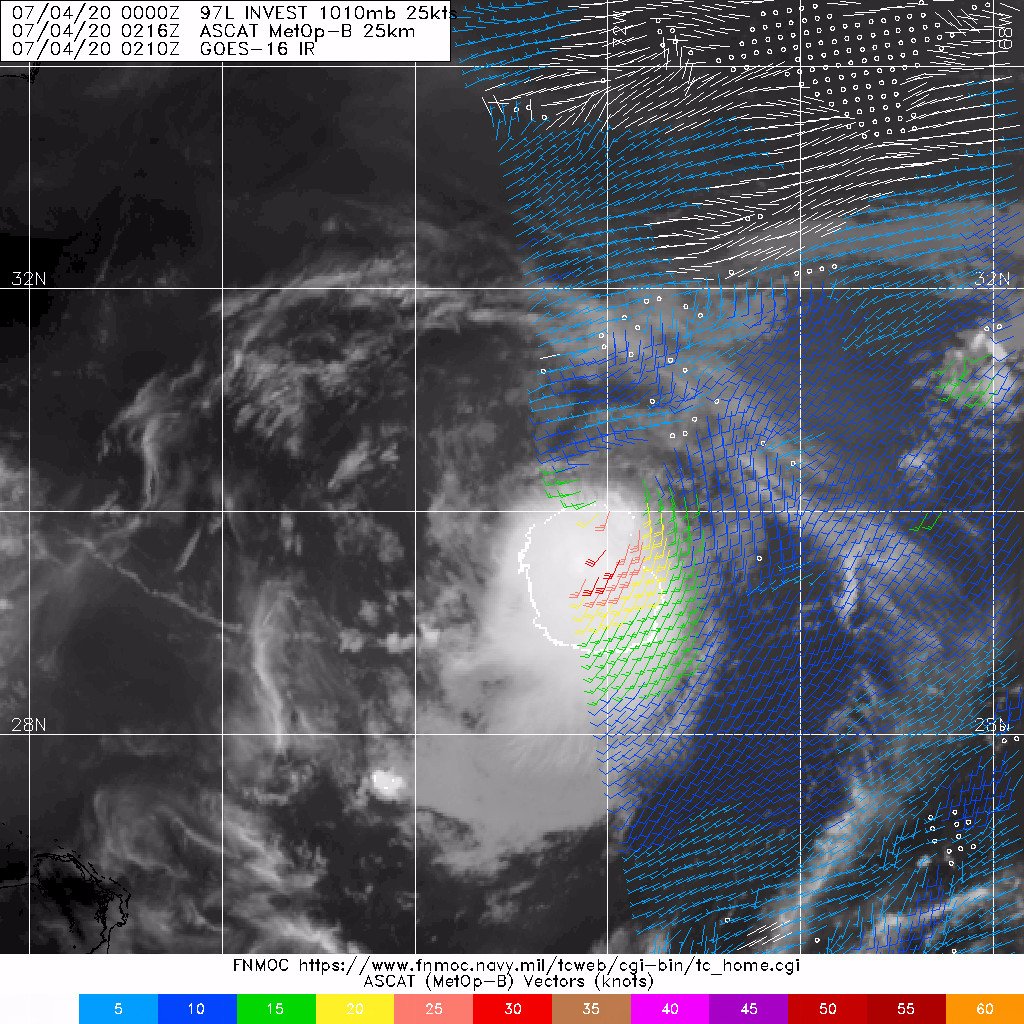
#22 Postby northjaxpro » Fri Jul 03, 2020 7:39 pm

TheStormExpert wrote:
northjaxpro wrote:97L is a very small cyclone and remember these small cyclones can ramp up very quickly. They have their own unique environment. I always remember Hurricane Danny in 2015, which was an extremely tiny TC and it intensified to become a Category 3 major in the MDR. If my memory serves me right, only the HWRF model had Danny even developing at all at that time.

Yes Danny defied the odds that anything of significance would come from the Tropical Atlantic that year considering the Super El Niño.


Yes indeed, in all my years of doing weather and followng the tropics, Danny is among my favorite storms to have analyzed and tracked. It only had one model (HWRF) having developed it. It was a major hurricane , and a tiny one, with hurricane force winds extendird out only 60 miles from the eye. You almost needed a mircroscope to find it on imagery seemingly LOL. Danny did not harm anyone or anything except the fish in the MDR thankfully.
Last edited by northjaxpro on Fri Jul 03, 2020 7:41 pm, edited 1 time in total.
2 likes   
NEVER, EVER SAY NEVER in the tropics and weather in general, and most importantly, with life itself!!

________________________________________________________________________________________

Fay 2008 Beryl 2012 Debby 2012 Colin 2016 Hermine 2016 Julia 2016 Matthew 2016 Irma 2017 Dorian 2019

User avatar
TheAustinMan
Category 5
Category 5
Posts: 1015
Age: 24
Joined: Mon Jul 08, 2013 4:26 pm
Location: United States
Contact:

Re: ATL: INVEST 97L - Discussion

#23 Postby TheAustinMan » Fri Jul 03, 2020 7:41 pm

Our little blob looked quite fruitful entering nightfall. Typically, we look to scatterometer data to provide a more definitive answer for these sorts of small circulations, since it can be a little tricky to distinguish mid-level or even low-level wind flow from surface flow on conventional satellite imagery. Unfortunately, it doesn't look like we'll get ASCAT data tonight (though perhaps one of the other scatterometers active now might catch it). That said, the latest infrared imagery, nighttime microphysics data, and this microwave image below do seem mildly suggestive of a circulation. The -75C overshooting tops are definitely an added bonus.

1.1 MB. Source: FNMOC
Image
5 likes   
ImageImageImage
Treat my opinions with a grain of salt. For official information see your local weather service.

Sciencerocks
Category 5
Category 5
Posts: 7300
Age: 38
Joined: Thu Jul 06, 2017 1:51 am

Re: ATL: INVEST 97L - Discussion

#24 Postby Sciencerocks » Fri Jul 03, 2020 7:43 pm

I would have want 80% with that clearly defined LLC under the deep convection...

This thing should be getting numbered or named within the next 12-24 hours...IMO. 8-)
Image
2 likes   


Aric Dunn
Category 5
Category 5
Posts: 21228
Age: 41
Joined: Sun Sep 19, 2004 9:58 pm
Location: Ready for the Chase.
Contact:

Re: ATL: INVEST 97L - Discussion

#26 Postby Aric Dunn » Fri Jul 03, 2020 8:27 pm

mid level shear is currently out of the north. that should shift more out of the WNW to NW which will allow convection to expand farther north.
0 likes   
Note: If I make a post that is brief. Please refer back to previous posts for the analysis or reasoning. I do not re-write/qoute what my initial post said each time.
If there is nothing before... then just ask :)

Space & Atmospheric Physicist, Embry-Riddle Aeronautical University,
I believe the sky is falling...

User avatar
TheStormExpert
Category 5
Category 5
Posts: 8487
Age: 30
Joined: Wed Feb 16, 2011 5:38 pm
Location: Palm Beach Gardens, FL

Re: ATL: INVEST 97L - Discussion

#27 Postby TheStormExpert » Fri Jul 03, 2020 8:46 pm

Aric Dunn wrote:mid level shear is currently out of the north. that should shift more out of the WNW to NW which will allow convection to expand farther north.

Mid-Level Shear shouldn't be too much of an issue.

Image
0 likes   
The following post is NOT an official forecast and should not be used as such. It is just the opinion of the poster and may or may not be backed by sound meteorological data. It is NOT endorsed by storm2k.org.

Aric Dunn
Category 5
Category 5
Posts: 21228
Age: 41
Joined: Sun Sep 19, 2004 9:58 pm
Location: Ready for the Chase.
Contact:

Re: ATL: INVEST 97L - Discussion

#28 Postby Aric Dunn » Fri Jul 03, 2020 9:04 pm

couple long feeder bands starting to build.

looks like they will have to back up the development time.. once they upgrade tomorrow.
0 likes   
Note: If I make a post that is brief. Please refer back to previous posts for the analysis or reasoning. I do not re-write/qoute what my initial post said each time.
If there is nothing before... then just ask :)

Space & Atmospheric Physicist, Embry-Riddle Aeronautical University,
I believe the sky is falling...

plasticup
S2K Supporter
S2K Supporter
Posts: 1295
Joined: Thu Aug 05, 2010 5:49 pm
Location: Bermuda

Re: ATL: INVEST 97L - Discussion

#29 Postby plasticup » Fri Jul 03, 2020 9:22 pm

Bermuda is not expecting this!
1 likes   
Eyes: Emily '86, Dean '89, Felix '95, Gert '99, Fabian '03, Humberto '19, Paulette '20

User avatar
EquusStorm
Category 5
Category 5
Posts: 1649
Age: 33
Joined: Thu Nov 07, 2013 1:04 pm
Location: Jasper, AL
Contact:

Re: ATL: INVEST 97L - Discussion

#30 Postby EquusStorm » Fri Jul 03, 2020 9:52 pm

Well that escalated pretty quickly. Shall we prepare the welcome wagon for Edouard so soon?
0 likes   
Colors of lost purpose on the canvas of irrelevance

Not a meteorologist, in fact more of an idiot than anything. You should probably check with the NHC or a local NWS office for official information.

Aric Dunn
Category 5
Category 5
Posts: 21228
Age: 41
Joined: Sun Sep 19, 2004 9:58 pm
Location: Ready for the Chase.
Contact:

Re: ATL: INVEST 97L - Discussion

#31 Postby Aric Dunn » Fri Jul 03, 2020 10:01 pm

EquusStorm wrote:Well that escalated pretty quickly. Shall we prepare the welcome wagon for Edouard so soon?


I would say so...

probably by morning visible. or if we get an ASCAT here in the next couple hours.
0 likes   
Note: If I make a post that is brief. Please refer back to previous posts for the analysis or reasoning. I do not re-write/qoute what my initial post said each time.
If there is nothing before... then just ask :)

Space & Atmospheric Physicist, Embry-Riddle Aeronautical University,
I believe the sky is falling...

User avatar
northjaxpro
S2K Supporter
S2K Supporter
Posts: 8900
Joined: Mon Sep 27, 2010 11:21 am
Location: Jacksonville, FL

Re: ATL: INVEST 97L - Discussion

#32 Postby northjaxpro » Fri Jul 03, 2020 10:10 pm

The cyclone still maintaining solid convection over the circulation center this hour. Again as I pointed out earlier these very small cyclones like this one can be extremely tricky to analyze and also for the reliable models. They can intensify rapidly. That is why I think it is a reasonable possibility that 97L could be stronger imo.
2 likes   
NEVER, EVER SAY NEVER in the tropics and weather in general, and most importantly, with life itself!!

________________________________________________________________________________________

Fay 2008 Beryl 2012 Debby 2012 Colin 2016 Hermine 2016 Julia 2016 Matthew 2016 Irma 2017 Dorian 2019

Aric Dunn
Category 5
Category 5
Posts: 21228
Age: 41
Joined: Sun Sep 19, 2004 9:58 pm
Location: Ready for the Chase.
Contact:

Re: ATL: INVEST 97L - Discussion

#33 Postby Aric Dunn » Fri Jul 03, 2020 10:17 pm

northjaxpro wrote:The cyclone still maintaining solid convection over the circulation center this hour. Again as I pointed out earlier these very small cyclones like this one can be extremely tricky to analyze and also for the reliable models. They can intensify rapidly. That is why I think it is a reasonable possibility that 97L could be stronger imo.


yeah it is almost certainly a TS.
1 likes   
Note: If I make a post that is brief. Please refer back to previous posts for the analysis or reasoning. I do not re-write/qoute what my initial post said each time.
If there is nothing before... then just ask :)

Space & Atmospheric Physicist, Embry-Riddle Aeronautical University,
I believe the sky is falling...

User avatar
Nancy Smar
Category 5
Category 5
Posts: 1081
Age: 23
Joined: Wed Aug 16, 2017 10:03 pm

Re: ATL: INVEST 97L - Discussion

#34 Postby Nancy Smar » Fri Jul 03, 2020 10:17 pm

Image
0 likes   

Aric Dunn
Category 5
Category 5
Posts: 21228
Age: 41
Joined: Sun Sep 19, 2004 9:58 pm
Location: Ready for the Chase.
Contact:

Re: ATL: INVEST 97L - Discussion

#35 Postby Aric Dunn » Fri Jul 03, 2020 10:29 pm


too bad it just clipped it. ambiguities will likely be quite high.

A and C passes should come in the couple hours..
0 likes   
Note: If I make a post that is brief. Please refer back to previous posts for the analysis or reasoning. I do not re-write/qoute what my initial post said each time.
If there is nothing before... then just ask :)

Space & Atmospheric Physicist, Embry-Riddle Aeronautical University,
I believe the sky is falling...

User avatar
Ubuntwo
Category 5
Category 5
Posts: 1089
Age: 30
Joined: Thu Oct 05, 2017 10:41 pm

Re: ATL: INVEST 97L - Discussion

#36 Postby Ubuntwo » Fri Jul 03, 2020 10:32 pm


I was right on the money with 30kt. Still hasn't established easterlies, there may be a storm relative circulation but not an earth relative circulation.
1 likes   
Kendall -> SLO -> PBC

Memorable Storms: Katrina (for its Florida landfall...) Wilma Matthew Irma

Aric Dunn
Category 5
Category 5
Posts: 21228
Age: 41
Joined: Sun Sep 19, 2004 9:58 pm
Location: Ready for the Chase.
Contact:

Re: ATL: INVEST 97L - Discussion

#37 Postby Aric Dunn » Fri Jul 03, 2020 10:38 pm

Ubuntwo wrote:

I was right on the money with 30kt. Still hasn't established easterlies, there may be a storm relative circulation but not an earth relative circulation.


Dont get too ahead of yourself. :P

ambiguity is going to be high on this scale and edge of the pass.. as usual.

also the wind field earlier was closed. with a slight attachment to the trough.

with the deep convection, it is not going to all of a sudden start diverging at the surface.

have to wait for A and C passes shortly.


Edit.. ASCAT-A missed the circ completely. hopefully C will cove rit.
1 likes   
Note: If I make a post that is brief. Please refer back to previous posts for the analysis or reasoning. I do not re-write/qoute what my initial post said each time.
If there is nothing before... then just ask :)

Space & Atmospheric Physicist, Embry-Riddle Aeronautical University,
I believe the sky is falling...

User avatar
Ubuntwo
Category 5
Category 5
Posts: 1089
Age: 30
Joined: Thu Oct 05, 2017 10:41 pm

Re: ATL: INVEST 97L - Discussion

#38 Postby Ubuntwo » Fri Jul 03, 2020 10:46 pm

Aric Dunn wrote:
Ubuntwo wrote:

I was right on the money with 30kt. Still hasn't established easterlies, there may be a storm relative circulation but not an earth relative circulation.


Dont get too ahead of yourself. :P

ambiguity is going to be high on this scale and edge of the pass.. as usual.

also the wind field earlier was closed. with a slight attachment to the trough.

with the deep convection, it is not going to all of a sudden start diverging at the surface.

have to wait for A and C passes shortly.


Edit.. ASCAT-A missed the circ completely. hopefully C will cove rit.


It's still somewhat attached to the trough. You can see the low level cloud lines extending to the NE. If convection can establish itself to the north of the center, then this very likely gets a closed circ.
0 likes   
Kendall -> SLO -> PBC

Memorable Storms: Katrina (for its Florida landfall...) Wilma Matthew Irma

User avatar
Nancy Smar
Category 5
Category 5
Posts: 1081
Age: 23
Joined: Wed Aug 16, 2017 10:03 pm

Re: ATL: INVEST 97L - Discussion

#39 Postby Nancy Smar » Fri Jul 03, 2020 10:49 pm

AL, 97, 2020070400, , BEST, 0, 300N, 730W, 30, 1009, LO,
0 likes   

Aric Dunn
Category 5
Category 5
Posts: 21228
Age: 41
Joined: Sun Sep 19, 2004 9:58 pm
Location: Ready for the Chase.
Contact:

Re: ATL: INVEST 97L - Discussion

#40 Postby Aric Dunn » Fri Jul 03, 2020 10:51 pm

CFOSAT

The resolution is lower and from almost 4 hours ago.

But showing an organized system. trough then was barely attached.

wind bards are closed the trough only affecting the outer circulation.

Image
0 likes   
Note: If I make a post that is brief. Please refer back to previous posts for the analysis or reasoning. I do not re-write/qoute what my initial post said each time.
If there is nothing before... then just ask :)

Space & Atmospheric Physicist, Embry-Riddle Aeronautical University,
I believe the sky is falling...


Return to “2020”

Who is online

Users browsing this forum: No registered users and 10 guests