ATL: CRISTOBAL - Models
Moderator: S2k Moderators

Re: ATL: INVEST 93L - Models
I would expect a shift east with today’s 12z Euro. My bet is on the central part of the Louisiana coast.
1 likes
-
Aric Dunn
- Category 5

- Posts: 21238
- Age: 43
- Joined: Sun Sep 19, 2004 9:58 pm
- Location: Ready for the Chase.
- Contact:
Re: ATL: INVEST 93L - Models
12z Euro has not initialized the vorticity of amanda in the correct location for some reason.
1 likes
Note: If I make a post that is brief. Please refer back to previous posts for the analysis or reasoning. I do not re-write/qoute what my initial post said each time.
If there is nothing before... then just ask
Space & Atmospheric Physicist, Embry-Riddle Aeronautical University,
I believe the sky is falling...
If there is nothing before... then just ask
Space & Atmospheric Physicist, Embry-Riddle Aeronautical University,
I believe the sky is falling...
Re: ATL: INVEST 93L - Models
MississippiWx wrote:Very complex scenario here. Amanda could possibly survive well enough to redevelop in the BOC as the Euro/CMC/HWRF suggest. Even the GFS and Ukmet suggest this occurs. The difference is the way they move it back into Mexico. After this occurs, another lobe of energy (remnants?) rotate around the east side of the CAG and develops yet another storm off the Northern Yucatán.
Many different outcomes at play here, all feasible. Regardless, I’d say the chances of a tropical cyclone somewhere in the GOM are fairly high this upcoming week.
Because of that loop this looks to develop just to the north of the Yucatán compared to the BOC. That’s the change since yesterday and that’s why the models are shifting east.
1 likes

Re: ATL: INVEST 93L - Models
wxman22 wrote:Cpv17 wrote:SouthDadeFish wrote:I think focusing on any particular landfall location at this point in time is a futile endeavor. The long-term details of the storm are highly sensitive to which vorticity maximum becomes dominant over the next 2-3 days. Will TS Amanda remain the dominant vorticity maximum in the Gulf? The 12Z GFS suggests no. The 00Z EC suggests maybe. The 12Z GEM suggests yes. This has large implications on track, intensity, and most of all, timing.
I would imagine which vorticity max becomes dominant out of the gyre is highly sensitive to diabatic (convective) processes which are notoriously challenging to predict. Just keep this all in mind when you view model forecasts over the next 1-2 days. I imagine we will see lots of waffling.
But the consensus in all models right now is the TX/LA border even though some of the models are developing different areas of low pressure in different areas.
There really is no consensus yet, models and there ensembles show anything from the upper Texas coast to southeast Louisiana that's a pretty broad area . It will be a few more days before we have a true consensus as center relocation is likely at this point which will have large impacts on landfall location.
No consensus yet except probably that we will get a storm. Here's where we are now:
ICON - Landfall roughly 168 hours/next Sunday morning in Cameron Parish, LA looks like TS
GFS - Landfall roughly Tuesday morning 6/9 around Chambers County, TX looks like TS
CMC - Landfall roughly at Terrebonne Bay (south of Houma) Saturday night looks like TS
UKMET - Gets to the Center of the Gulf at the end of that US Tropics run
So that's 4 on board with SCLA to SETX. For the mesoscales, NAM 12km is still spinning in the Bay of Campeche at its end in 84 hours.
1 likes


Re: ATL: INVEST 93L - Models
Steve wrote:wxman22 wrote:Cpv17 wrote:
But the consensus in all models right now is the TX/LA border even though some of the models are developing different areas of low pressure in different areas.
There really is no consensus yet, models and there ensembles show anything from the upper Texas coast to southeast Louisiana that's a pretty broad area . It will be a few more days before we have a true consensus as center relocation is likely at this point which will have large impacts on landfall location.
No consensus yet except probably that we will get a storm. Here's where we are now:
ICON - Landfall roughly 168 hours/next Sunday morning in Cameron Parish, LA looks like TS
GFS - Landfall roughly Tuesday morning 6/9 around Chambers County, TX looks like TS
CMC - Landfall roughly at Terrebonne Bay (south of Houma) Saturday night looks like TS
UKMET - Gets to the Center of the Gulf at the end of that US Tropics run
So that's 4 on board with SCLA to SETX. For the mesoscales, NAM 12km is still spinning in the Bay of Campeche at its end in 84 hours.
Which of these tend to be more reliable overall in recent years?
0 likes
Not a professional forecast by any means.
Audrey'57, Hilda'64, Betsy '65, Edith'71, Carmen'74, Danny'85, Juan'85, Andrew'92, Iniki'92 (while on vacation in Kauai), Lili'02, Rita'05, Humberto'07, Gustav'08, Ike'08, Isaac'12, Monsoonal Depression'16, Harvey'17, Barry'19, Laura'20, Delta'20, Ida'21.
Audrey'57, Hilda'64, Betsy '65, Edith'71, Carmen'74, Danny'85, Juan'85, Andrew'92, Iniki'92 (while on vacation in Kauai), Lili'02, Rita'05, Humberto'07, Gustav'08, Ike'08, Isaac'12, Monsoonal Depression'16, Harvey'17, Barry'19, Laura'20, Delta'20, Ida'21.

Re: ATL: INVEST 93L - Models
12z HWRF is indeed further East with a landfall at 126 hours near Mobile, Alabama as a borderline TS/cat 1 hurricane.

0 likes

-
Aric Dunn
- Category 5
- Posts: 21238
- Age: 43
- Joined: Sun Sep 19, 2004 9:58 pm
- Location: Ready for the Chase.
- Contact:
Re: ATL: INVEST 93L - Models
12z HWRF. besides the loose nature of the CORE on the HWRF the upper environment appears to imprrove and become quite favorable.

0 likes
Note: If I make a post that is brief. Please refer back to previous posts for the analysis or reasoning. I do not re-write/qoute what my initial post said each time.
If there is nothing before... then just ask
Space & Atmospheric Physicist, Embry-Riddle Aeronautical University,
I believe the sky is falling...
If there is nothing before... then just ask
Space & Atmospheric Physicist, Embry-Riddle Aeronautical University,
I believe the sky is falling...
-
tarheelprogrammer

- S2K Supporter

- Posts: 1793
- Joined: Mon Mar 28, 2016 9:25 pm
- Location: Raleigh, NC area (Garner, NC)
Re: ATL: INVEST 93L - Models
Just one model run, but the 12z ECMWF has the BOC crossover. However, the redevelopment to the NE is weak and strung out.
1 likes
My posts are not official forecasts. They are just my opinion and may or may not be backed by sound meteorological data. They are NOT endorsed by any professional institution or storm2k.org. For official information, please refer to the NHC and NWS products.
Re: ATL: INVEST 93L - Models
Man, what a shift to the east in the models today. Now Mississippi and Alabama are in play.
0 likes
-
Aric Dunn
- Category 5
- Posts: 21238
- Age: 43
- Joined: Sun Sep 19, 2004 9:58 pm
- Location: Ready for the Chase.
- Contact:
Re: ATL: INVEST 93L - Models
euro initialized the location of Amanda about 12 hours earlier from its current position. and then when it does make it over the BOC it dives it back into mexico and dies then a secondary circ develops to the NE.
if the circ stays over water like the rest of the models then we wont see this.
if the circ stays over water like the rest of the models then we wont see this.
1 likes
Note: If I make a post that is brief. Please refer back to previous posts for the analysis or reasoning. I do not re-write/qoute what my initial post said each time.
If there is nothing before... then just ask
Space & Atmospheric Physicist, Embry-Riddle Aeronautical University,
I believe the sky is falling...
If there is nothing before... then just ask
Space & Atmospheric Physicist, Embry-Riddle Aeronautical University,
I believe the sky is falling...
-
Aric Dunn
- Category 5
- Posts: 21238
- Age: 43
- Joined: Sun Sep 19, 2004 9:58 pm
- Location: Ready for the Chase.
- Contact:
Re: ATL: INVEST 93L - Models
Well played Euro Well Played.. lol
0 likes
Note: If I make a post that is brief. Please refer back to previous posts for the analysis or reasoning. I do not re-write/qoute what my initial post said each time.
If there is nothing before... then just ask
Space & Atmospheric Physicist, Embry-Riddle Aeronautical University,
I believe the sky is falling...
If there is nothing before... then just ask
Space & Atmospheric Physicist, Embry-Riddle Aeronautical University,
I believe the sky is falling...
-
Aric Dunn
- Category 5
- Posts: 21238
- Age: 43
- Joined: Sun Sep 19, 2004 9:58 pm
- Location: Ready for the Chase.
- Contact:
Re: ATL: INVEST 93L - Models
Since the vorticity was initialized well south offshore I am going to disregard this Euro run for now. ensembles should be interesting.
0 likes
Note: If I make a post that is brief. Please refer back to previous posts for the analysis or reasoning. I do not re-write/qoute what my initial post said each time.
If there is nothing before... then just ask
Space & Atmospheric Physicist, Embry-Riddle Aeronautical University,
I believe the sky is falling...
If there is nothing before... then just ask
Space & Atmospheric Physicist, Embry-Riddle Aeronautical University,
I believe the sky is falling...
-
wxman57

- Moderator-Pro Met

- Posts: 23172
- Age: 68
- Joined: Sat Jun 21, 2003 8:06 pm
- Location: Houston, TX (southwest)
Re: ATL: INVEST 93L - Models
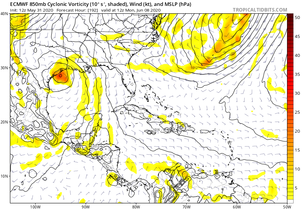
Euro dissipates whatever is left of Amanda over southern Mexico late Wednesday. The low it takes into the TX coast is a new development.
1 likes
-
PTrackerLA

- Category 5
- Posts: 5281
- Age: 42
- Joined: Thu Oct 10, 2002 8:40 pm
- Location: Lafayette, LA
Re: ATL: INVEST 93L - Models
Aric Dunn wrote:Since the vorticity was initialized well south offshore I am going to disregard this Euro run for now. ensembles should be interesting.
The whole 12z run was a mess if you were trying to follow the vorticity lol.
1 likes

Re: ATL: INVEST 93L - Models
wxman57 wrote:Euro dissipates whatever is left of Amanda over southern Mexico late Wednesday. The low it takes into the TX coast is a new development.
It seems like the GFS and Euro are hinting at some separate development down the line. That system has popped up in a couple of GFS runs as well. It’ll be crazy if we get to Dolly before June 10th, but it’s still rather far out and can easily bust like 92L.
0 likes
Irene '11 Sandy '12 Hermine '16 5/15/2018 Derecho Fay '20 Isaias '20 Elsa '21 Henri '21 Ida '21
I am only a meteorology enthusiast who knows a decent amount about tropical cyclones. Look to the professional mets, the NHC, or your local weather office for the best information.
I am only a meteorology enthusiast who knows a decent amount about tropical cyclones. Look to the professional mets, the NHC, or your local weather office for the best information.
-
PTrackerLA
- Category 5
- Posts: 5281
- Age: 42
- Joined: Thu Oct 10, 2002 8:40 pm
- Location: Lafayette, LA
Re: ATL: INVEST 93L - Models
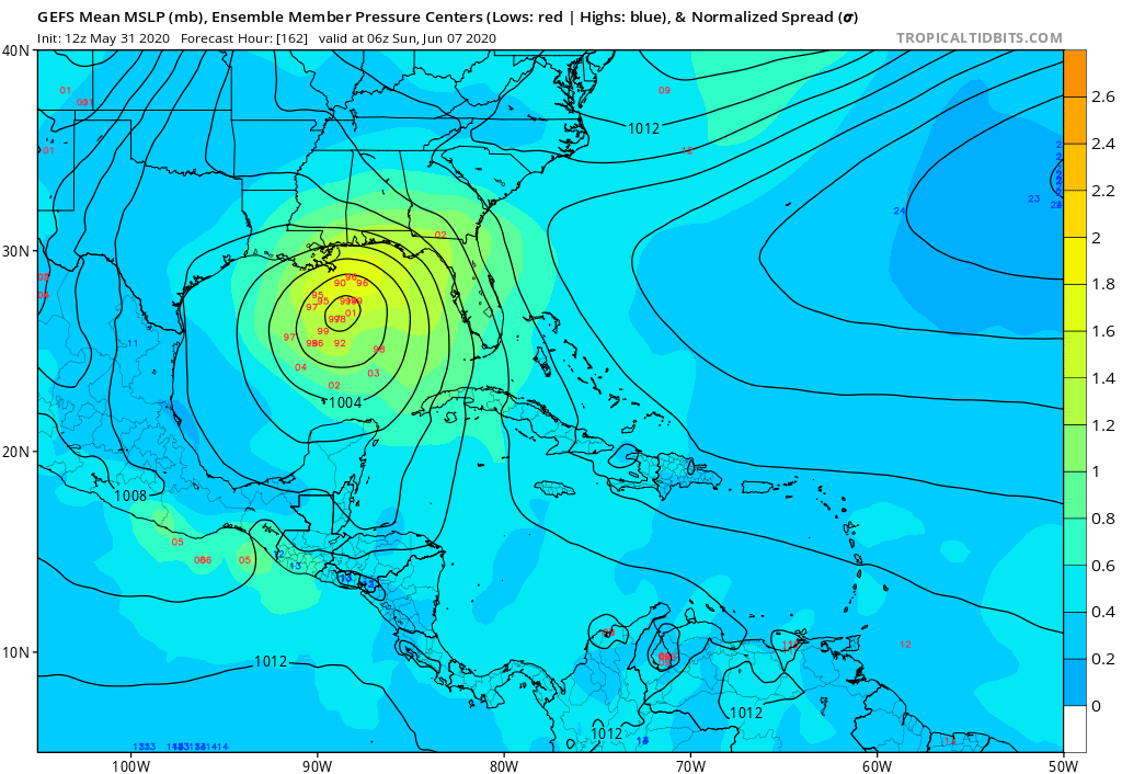
12z Euro ensembles coming in even more aggressive. Several members now in the 950mb range targeting TX/LA.
3 likes
Re: ATL: INVEST 93L - Models
Well heck, I guess everyone from Mexico to Florida is still in play. Confusing situation.
0 likes
Re: ATL: INVEST 93L - Models
PTrackerLA wrote:12z Euro ensembles coming in even more aggressive. Several members now in the 950mb range targeting TX/LA.
Has there ever been a major hurricane in June? I know Alex ‘10 got really close, with a central pressure just under 950 mbar.
0 likes
Irene '11 Sandy '12 Hermine '16 5/15/2018 Derecho Fay '20 Isaias '20 Elsa '21 Henri '21 Ida '21
I am only a meteorology enthusiast who knows a decent amount about tropical cyclones. Look to the professional mets, the NHC, or your local weather office for the best information.
I am only a meteorology enthusiast who knows a decent amount about tropical cyclones. Look to the professional mets, the NHC, or your local weather office for the best information.
Who is online
Users browsing this forum: No registered users and 50 guests