ATL: ISAIAS - Models
Moderator: S2k Moderators
-
toad strangler

- S2K Supporter

- Posts: 4546
- Joined: Sun Jul 28, 2013 3:09 pm
- Location: Earth
- Contact:
Re: ATL: INVEST 92L - Models
Every model I've looked at does show that Azores based High. That's a recipe to keep this system away from the GOM. IF it verifies. Just commenting on recent runs.
0 likes
My Weather Station
https://www.wunderground.com/dashboard/pws/KFLPORTS603
https://www.wunderground.com/dashboard/pws/KFLPORTS603
-
AutoPenalti
- Category 5

- Posts: 4091
- Age: 29
- Joined: Mon Aug 17, 2015 4:16 pm
- Location: Ft. Lauderdale, Florida
Re: ATL: INVEST 92L - Models
Looks like EURO weakens the trough and it pulls up. Ridge builds back in, tracking WNW.
0 likes
The posts in this forum are NOT official forecasts and should not be used as such. They are just the opinion of the poster and may or may not be backed by sound meteorological data. They are NOT endorsed by any professional institution or STORM2K. For official information, please refer to products from the NHC and NWS.
Model Runs Cheat Sheet:
GFS (5:30 AM/PM, 11:30 AM/PM)
HWRF, GFDL, UKMET, NAVGEM (6:30-8:00 AM/PM, 12:30-2:00 AM/PM)
ECMWF (1:45 AM/PM)
TCVN is a weighted averaged
-
HurricaneFrances04
- Category 2

- Posts: 597
- Joined: Mon Jun 25, 2012 8:09 am
- Location: Fort Lauderdale, Florida
Re: ATL: INVEST 92L - Models
GFS and Euro at the same location @ 216 hours, believe it or not.
0 likes

Re: ATL: INVEST 92L - Models
Good news is that the EURO indicates weakening at 216 hours. Bad news is that it appears that the Central Plains ridging is bridging eastward over the S.E. CONUS. That might imply the current 240 hr. to soon show more of a left turn. Long long way off still.........
0 likes
Andy D
(For official information, please refer to the NHC and NWS products.)
(For official information, please refer to the NHC and NWS products.)
-
toad strangler
- S2K Supporter
- Posts: 4546
- Joined: Sun Jul 28, 2013 3:09 pm
- Location: Earth
- Contact:
Re: ATL: INVEST 92L - Models
Weak Sauce through the Bahamas at 216 heading NW
0 likes
My Weather Station
https://www.wunderground.com/dashboard/pws/KFLPORTS603
https://www.wunderground.com/dashboard/pws/KFLPORTS603
-
AutoPenalti
- Category 5
- Posts: 4091
- Age: 29
- Joined: Mon Aug 17, 2015 4:16 pm
- Location: Ft. Lauderdale, Florida
Re: ATL: INVEST 92L - Models
Isaías weakening, mid range TS in the Bahamas.
0 likes
The posts in this forum are NOT official forecasts and should not be used as such. They are just the opinion of the poster and may or may not be backed by sound meteorological data. They are NOT endorsed by any professional institution or STORM2K. For official information, please refer to products from the NHC and NWS.
Model Runs Cheat Sheet:
GFS (5:30 AM/PM, 11:30 AM/PM)
HWRF, GFDL, UKMET, NAVGEM (6:30-8:00 AM/PM, 12:30-2:00 AM/PM)
ECMWF (1:45 AM/PM)
TCVN is a weighted averaged
Re: ATL: INVEST 92L - Models
When you think about it, pretty darned remarkable agreement between Euro, UK, GFS, Icon and JMA a week out.
But take heart, as everyone who has followed these threads over the years fully knows. The ONLY thing we can be completely sure of is that it will not play out precisely as depicted
But take heart, as everyone who has followed these threads over the years fully knows. The ONLY thing we can be completely sure of is that it will not play out precisely as depicted
Last edited by sma10 on Sat Jul 25, 2020 1:58 pm, edited 1 time in total.
3 likes
-
toad strangler
- S2K Supporter
- Posts: 4546
- Joined: Sun Jul 28, 2013 3:09 pm
- Location: Earth
- Contact:
Re: ATL: INVEST 92L - Models
12z Euro ends with a weak low heading towards the Carolinas. Next suite please.
0 likes
My Weather Station
https://www.wunderground.com/dashboard/pws/KFLPORTS603
https://www.wunderground.com/dashboard/pws/KFLPORTS603
-
Hurricaneman

- Category 5
- Posts: 7404
- Age: 45
- Joined: Tue Aug 31, 2004 3:24 pm
- Location: central florida
Re: ATL: INVEST 92L - Models
Lock it in, landfall between Cape Hatteras and Jacksonville according to the GFS and Euro
jk/ it’s too far out to really know strength or location but the models are showing something in the Bahamas in 8 to 9 days so it’s something to monitor after Hanna
jk/ it’s too far out to really know strength or location but the models are showing something in the Bahamas in 8 to 9 days so it’s something to monitor after Hanna
Last edited by Hurricaneman on Sat Jul 25, 2020 2:00 pm, edited 1 time in total.
1 likes
Re: ATL: INVEST 92L - Models
toad strangler wrote:12z Euro ends with a weak low heading towards the Carolinas. Next suite please.
Stop.
0 likes
-
HurricaneFrances04
- Category 2
- Posts: 597
- Joined: Mon Jun 25, 2012 8:09 am
- Location: Fort Lauderdale, Florida
Re: ATL: INVEST 92L - Models
Ridge builds in. Another east coast hit. Interaction with hispaniola is the wild card.
0 likes
-
AutoPenalti
- Category 5
- Posts: 4091
- Age: 29
- Joined: Mon Aug 17, 2015 4:16 pm
- Location: Ft. Lauderdale, Florida
Re: ATL: INVEST 92L - Models
Not sure what caused the weakening (maybe Hispaniola?) but 12z runs have nudged north from last nights runs.
0 likes
The posts in this forum are NOT official forecasts and should not be used as such. They are just the opinion of the poster and may or may not be backed by sound meteorological data. They are NOT endorsed by any professional institution or STORM2K. For official information, please refer to products from the NHC and NWS.
Model Runs Cheat Sheet:
GFS (5:30 AM/PM, 11:30 AM/PM)
HWRF, GFDL, UKMET, NAVGEM (6:30-8:00 AM/PM, 12:30-2:00 AM/PM)
ECMWF (1:45 AM/PM)
TCVN is a weighted averaged
-
TheStormExpert
Re: ATL: INVEST 92L - Models
I’m getting Matthew/Dorian vibes from 92L. Folks here in metropolitan SE Florida have been so lucky here since 2016 with the three majors that came close but missed in terms of sustained hurricane winds.
0 likes
-
TheStormExpert
Re: ATL: INVEST 92L - Models
HurricaneFrances04 wrote:GFS and Euro at the same location @ 216 hours, believe it or not.
Same location, much different intensity.
3 likes
-
TheStormExpert
Re: ATL: INVEST 92L - Models
The 500mb pattern looks very progressive across the U.S. So it will be critical as to whether this gets caught by the ridge or swept away out to sea by a trough. Right now the NAO is negative trending positive.
0 likes
-
DestinHurricane

- Category 4

- Posts: 935
- Joined: Tue May 01, 2018 8:05 am
- Location: New York, NY
Re: ATL: INVEST 92L - Models
The question is whether it's going to take an Irma, Dorian, Irene, or Jose track. (Not intensity)
0 likes
Michael 2018
-
AutoPenalti
- Category 5
- Posts: 4091
- Age: 29
- Joined: Mon Aug 17, 2015 4:16 pm
- Location: Ft. Lauderdale, Florida
Re: ATL: INVEST 92L - Models
Welp, we have 6 full days of model runs before it starts getting chaotic.
1 likes
The posts in this forum are NOT official forecasts and should not be used as such. They are just the opinion of the poster and may or may not be backed by sound meteorological data. They are NOT endorsed by any professional institution or STORM2K. For official information, please refer to products from the NHC and NWS.
Model Runs Cheat Sheet:
GFS (5:30 AM/PM, 11:30 AM/PM)
HWRF, GFDL, UKMET, NAVGEM (6:30-8:00 AM/PM, 12:30-2:00 AM/PM)
ECMWF (1:45 AM/PM)
TCVN is a weighted averaged
-
OuterBanker
- S2K Supporter
- Posts: 1761
- Joined: Wed Feb 26, 2003 10:53 am
- Location: Nags Head, NC
- Contact:
Re: ATL: INVEST 92L - Models
Yes, latest Euro now has it as a weak 1002 low off Fl heading north toward the Carolina's.
After multiple runs as weak in the west carib/GoMex.
May I be excused, my brain is full.
At least it will lead to countless discussions over the next week.
After multiple runs as weak in the west carib/GoMex.
May I be excused, my brain is full.
At least it will lead to countless discussions over the next week.
2 likes
-
gatorcane

- S2K Supporter
- Posts: 23708
- Age: 48
- Joined: Sun Mar 13, 2005 3:54 pm
- Location: Boca Raton, FL
Re: ATL: INVEST 92L - Models
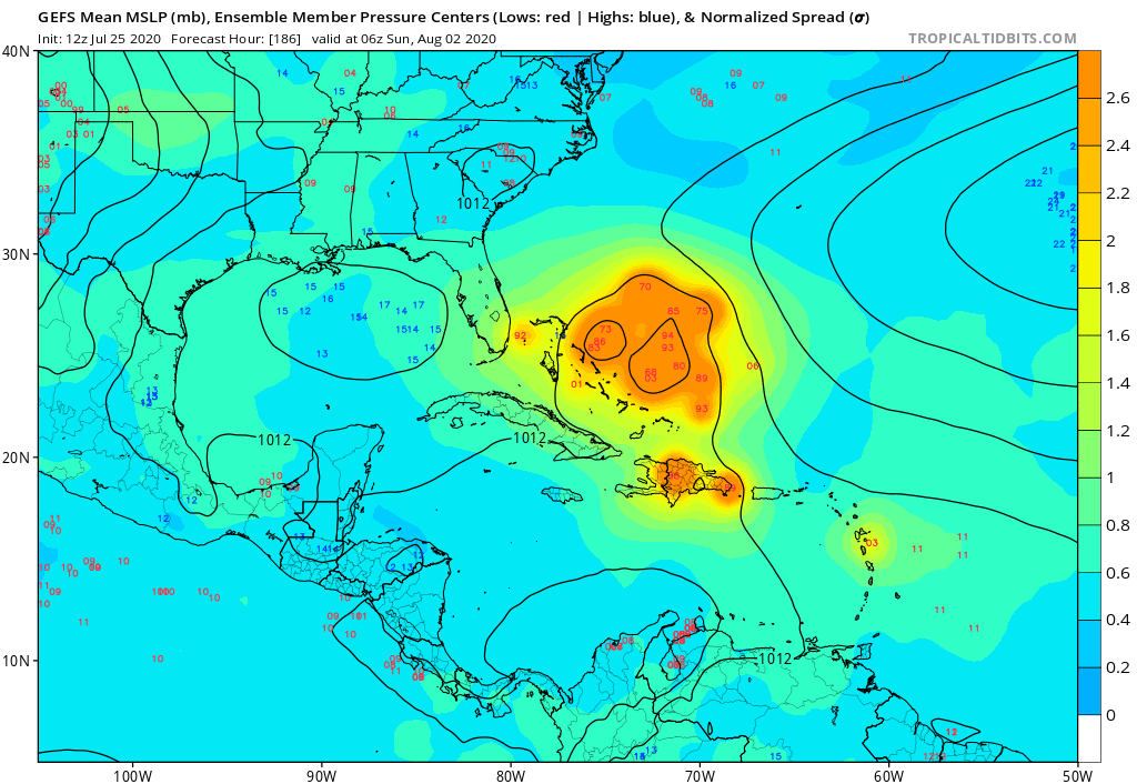
Didn’t see anyone post the GFS ensembles. They are MUCH stronger but most recurve well east of Florida and the Bahamas:
0 likes
-
toad strangler
- S2K Supporter
- Posts: 4546
- Joined: Sun Jul 28, 2013 3:09 pm
- Location: Earth
- Contact:
Re: ATL: INVEST 92L - Models
gatorcane wrote:Didn’t see anyone post the GFS ensembles. They are MUCH stronger but most recurve well east of Florida and the Bahamas:
https://i.postimg.cc/vmb6PV3t/gfs-ememb-lowlocs-watl-32.png
They were posted back on page 8
0 likes
My Weather Station
https://www.wunderground.com/dashboard/pws/KFLPORTS603
https://www.wunderground.com/dashboard/pws/KFLPORTS603
Who is online
Users browsing this forum: No registered users and 120 guests