ATL: HANNA - Remnants - Discussion
Moderator: S2k Moderators

Re: ATL: HANNA - Hurricane - Discussion
KNGP gusting to 59 mph now.
0 likes
Very useful information on the Dvorak Technique --
https://severe.worldweather.wmo.int/TCF ... kBeven.pdf
https://severe.worldweather.wmo.int/TCF ... kBeven.pdf

Re: ATL: HANNA - Hurricane - Discussion
TheAustinMan wrote:An oblique view of Hanna from GOES-17 highlights the active convection in the southwestern eyewall and the dramatic clearing of the eye.
1.8 MB. Source: George C. Marshall Space Flight Center
https://i.imgur.com/YiK5yat.png
Hanna went to 'Dunkin last minute, quickly getting its act together now!
3 likes
Georges '98, Irene '99, Frances '04, Jeanne '04, Katrina '05, Wilma '05, Gustav '08, Isaac '12, Matthew '16, Florence '18, Michael '18, Ian '22
-
LAwxrgal

- S2K Supporter

- Posts: 1763
- Joined: Tue Jul 06, 2004 1:05 pm
- Location: Reserve, LA (30 mi west of NOLA)
Re: ATL: HANNA - Hurricane - Discussion
Good thing this storm doesn't have another day or so over water. Hopefully will be on shore within a few hours. Nevertheless, very heavy rain over the next few days in that area. What is it with Texas storms?
0 likes
Andrew 92/Isidore & Lili 02/Bill 03/Katrina & Rita 05/Gustav & Ike 08/Isaac 12 (flooded my house)/Harvey 17/Barry 19/Cristobal 20/Claudette 21/Ida 21 (In the Eye)/Francine 24
Wake me up when November ends
Wake me up when November ends
-
eastcoastFL

- Category 5

- Posts: 3996
- Age: 44
- Joined: Thu Apr 12, 2007 12:29 pm
- Location: Palm City, FL
Re: ATL: HANNA - Hurricane - Discussion
Hanna is looking the best she has yet on visible in my opinion. Still about 4-6 hrs left over water... could get up to 90mph

Last edited by eastcoastFL on Sat Jul 25, 2020 11:52 am, edited 1 time in total.
2 likes
Personal Forecast Disclaimer:
The posts in this forum are NOT official forecast and should not be used as such. They are just the opinion of the poster and may or may not be backed by sound meteorological data. They are NOT endorsed by any professional institution or storm2k.org. For official information, please refer to the NHC and NWS products.
The posts in this forum are NOT official forecast and should not be used as such. They are just the opinion of the poster and may or may not be backed by sound meteorological data. They are NOT endorsed by any professional institution or storm2k.org. For official information, please refer to the NHC and NWS products.

Re: ATL: HANNA - Hurricane - Discussion
AF307 is off to Hanna. It’s at ~90.7W right now, so it should be no more than an hour until it reaches the storm. I’m betting it’ll find an 80 kt/972 mbar Cat 1.
2 likes
Irene '11 Sandy '12 Hermine '16 5/15/2018 Derecho Fay '20 Isaias '20 Elsa '21 Henri '21 Ida '21
I am only a meteorology enthusiast who knows a decent amount about tropical cyclones. Look to the professional mets, the NHC, or your local weather office for the best information.
I am only a meteorology enthusiast who knows a decent amount about tropical cyclones. Look to the professional mets, the NHC, or your local weather office for the best information.
-
EquusStorm
- Category 5
- Posts: 1649
- Age: 35
- Joined: Thu Nov 07, 2013 1:04 pm
- Location: Jasper, AL
- Contact:
Re: ATL: HANNA - Hurricane - Discussion
Very impressive visible presentation. The year of the overperformers.
4 likes
Colors of lost purpose on the canvas of irrelevance
Not a meteorologist, in fact more of an idiot than anything. You should probably check with the NHC or a local NWS office for official information.
Not a meteorologist, in fact more of an idiot than anything. You should probably check with the NHC or a local NWS office for official information.
-
eastcoastFL
- Category 5
- Posts: 3996
- Age: 44
- Joined: Thu Apr 12, 2007 12:29 pm
- Location: Palm City, FL
Re: ATL: HANNA - Hurricane - Discussion
Pretty amazing how rapidly this storm was able to get from a TD to an impressive cat 1 in a day. Still quite a ways to go in hurricane season. Hopefully we don’t see many more in the gulf this summer. The water temps where Hanna is are 89F

0 likes
Personal Forecast Disclaimer:
The posts in this forum are NOT official forecast and should not be used as such. They are just the opinion of the poster and may or may not be backed by sound meteorological data. They are NOT endorsed by any professional institution or storm2k.org. For official information, please refer to the NHC and NWS products.
The posts in this forum are NOT official forecast and should not be used as such. They are just the opinion of the poster and may or may not be backed by sound meteorological data. They are NOT endorsed by any professional institution or storm2k.org. For official information, please refer to the NHC and NWS products.
Re: ATL: HANNA - Hurricane - Discussion
0 likes
Very useful information on the Dvorak Technique --
https://severe.worldweather.wmo.int/TCF ... kBeven.pdf
https://severe.worldweather.wmo.int/TCF ... kBeven.pdf
-
Ian2401
- Category 1

- Posts: 321
- Joined: Thu Sep 14, 2017 5:55 pm
- Location: Tallahassee, Florida
- Contact:
Re: ATL: HANNA - Hurricane - Discussion
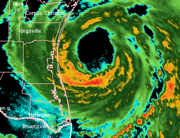
WOW that southern eyewall explosion of convection, absolutely nuts.
1 likes
B.S. Meteorology from Florida State '24 // Current M.S. Meteorology student at Florida State
Research Interests: Rapid Intensification, TC Climatology, TC Modeling
Consult the NHC for official information
Research Interests: Rapid Intensification, TC Climatology, TC Modeling
Consult the NHC for official information

Re: ATL: HANNA - Hurricane - Discussion
The tower really spun around fast.
Obscuring most of the eye now.
Obscuring most of the eye now.
1 likes

Re: ATL: HANNA - Hurricane - Discussion
EquusStorm wrote:Very impressive visible presentation. The year of the overperformers.
And to put this all in perspective, if Isaiah forms even on the later side of the model guidance it will be a full week before Irene formed in 2005
0 likes
Re: ATL: HANNA - Hurricane - Discussion
If this came into the east GoM as a TS, instead of a barely discernible wave, this would now be a major for sure.
What's coming down the road?
What's coming down the road?
Last edited by GCANE on Sat Jul 25, 2020 12:00 pm, edited 1 time in total.
5 likes
-
catskillfire51
- S2K Supporter
- Posts: 480
- Age: 39
- Joined: Sun Aug 26, 2012 5:40 pm
- Location: Lake Jackson, TX
Re: ATL: HANNA - Hurricane - Discussion
GCANE wrote:If this came into the east GoM as a TS, this would now be a major for sure.
What's coming down the road?
Euro has 92L making it to the gulf August 4th time frame, GFS takes it north of the islands and toward carolinas
1 likes
-
HurricaneAndre2008

- Category 1
- Posts: 356
- Age: 28
- Joined: Wed Jul 31, 2019 9:51 pm
- Contact:
Re: ATL: HANNA - Hurricane - Discussion
Current Intensity Analysis
UW - CIMSS
ADVANCED DVORAK TECHNIQUE
ADT-Version 9.0
Tropical Cyclone Intensity Algorithm
----- Current Analysis -----
Date : 25 JUL 2020 Time : 162024 UTC
Lat : 27:06:36 N Lon : 96:55:11 W
CI# /Pressure/ Vmax
4.5 / 970.9mb/ 77.0kt
UW - CIMSS
ADVANCED DVORAK TECHNIQUE
ADT-Version 9.0
Tropical Cyclone Intensity Algorithm
----- Current Analysis -----
Date : 25 JUL 2020 Time : 162024 UTC
Lat : 27:06:36 N Lon : 96:55:11 W
CI# /Pressure/ Vmax
4.5 / 970.9mb/ 77.0kt
2 likes
Cindy(2005), Katrina(2005), Rita(2005), Erin(2007), Isaac(2012)
Re: ATL: HANNA - Hurricane - Discussion
those CB's and subsequent sinking over the eye did wonders for Raw T #'s ahah
UW - CIMSS
ADVANCED DVORAK TECHNIQUE
ADT-Version 9.0
Tropical Cyclone Intensity Algorithm
----- Current Analysis -----
Date : 25 JUL 2020 Time : 162024 UTC
Lat : 27:06:36 N Lon : 96:55:11 W
CI# /Pressure/ Vmax
4.5 / 970.9mb/ 77.0kt
Final T# Adj T# Raw T#
4.5 4.5 6.3
ADVANCED DVORAK TECHNIQUE
ADT-Version 9.0
Tropical Cyclone Intensity Algorithm
----- Current Analysis -----
Date : 25 JUL 2020 Time : 162024 UTC
Lat : 27:06:36 N Lon : 96:55:11 W
CI# /Pressure/ Vmax
4.5 / 970.9mb/ 77.0kt
Final T# Adj T# Raw T#
4.5 4.5 6.3
5 likes
Very useful information on the Dvorak Technique --
https://severe.worldweather.wmo.int/TCF ... kBeven.pdf
https://severe.worldweather.wmo.int/TCF ... kBeven.pdf
-
Hurricane Mike
- Category 2

- Posts: 675
- Joined: Tue Apr 10, 2018 7:44 am
Re: ATL: HANNA - Hurricane - Discussion
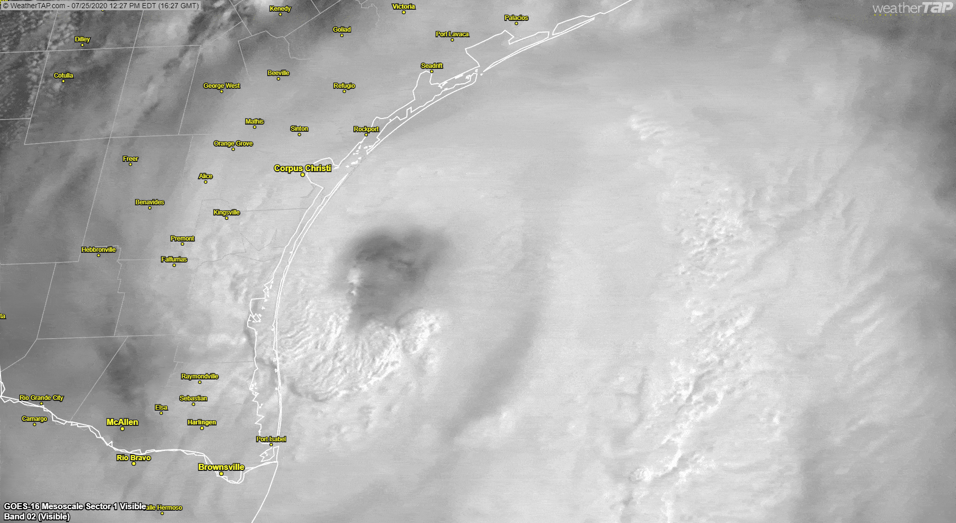
Feeder band NW of the CoC is breaking up as it crosses the coast.
This may be the peak for intensification.
This may be the peak for intensification.
1 likes
Re: ATL: HANNA - Hurricane - Discussion
Looking at radar, the western part of the eye is 12-14 miles from reaching Padre Island. It should begin moving onshore before 2 pm CDT. The eye appears to still be slightly contracting. I think recon could find a 90 mph hurricane if they make it in time.
5 likes
Re: ATL: HANNA - Hurricane - Discussion
Regardless of whatever strength Hanna ends up landfalling as, her presentation sure looks like something plucked right out of the WPAC

Last edited by tiger_deF on Sat Jul 25, 2020 12:10 pm, edited 1 time in total.
3 likes
-
supercane4867
- Category 5
- Posts: 4966
- Joined: Wed Nov 14, 2012 10:43 am
Who is online
Users browsing this forum: No registered users and 49 guests