ATL: ETA - Models
Moderator: S2k Moderators
-
TheStormExpert
Re: ATL: ETA - Models
12z Euro through 72hrs. misses the FL Keys to the south before diving SW.
1 likes
-
Emmett_Brown

- Category 5

- Posts: 1433
- Joined: Wed Aug 24, 2005 9:10 pm
- Location: Sarasota FL
Re: ATL: ETA - Models
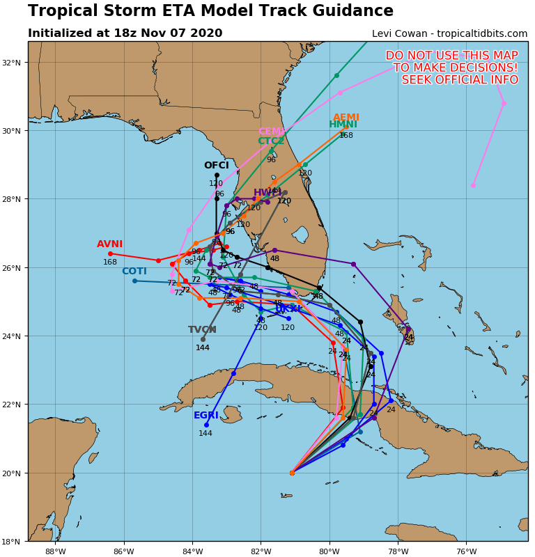
12Z GEFS ensemble shows some stronger members meandering Eta around the E GOM before hooking NE toward the FL W coast around 120 hours. Obviously the models will probably shift a bit more on future runs since the center of Eta was relocated this morning by recon.
https://www.weathernerds.org/tc_guidance/images/AL29_2020110712_GEFS_0-120h_large.png?1604770107
https://www.weathernerds.org/tc_guidance/images/AL29_2020110712_GEFS_0-120h_large.png?1604770107
Last edited by Emmett_Brown on Sat Nov 07, 2020 1:20 pm, edited 1 time in total.
1 likes

Re: ATL: ETA - Models
12z Euro shifted to the right on landfall in Cuba but past 24 hrs it is still very persistent on its track further west of the NHC track so far on this run.

1 likes
Re: ATL: ETA - Models
TheStormExpert wrote:12z Euro through 72hrs. misses the FL Keys to the south before diving SW.
No it does not, it shows it going right over Key West.
1 likes
-
gatorcane

- S2K Supporter

- Posts: 23708
- Age: 48
- Joined: Sun Mar 13, 2005 3:54 pm
- Location: Boca Raton, FL
Re: ATL: ETA - Models

2 likes
-
TheStormExpert
Re: ATL: ETA - Models
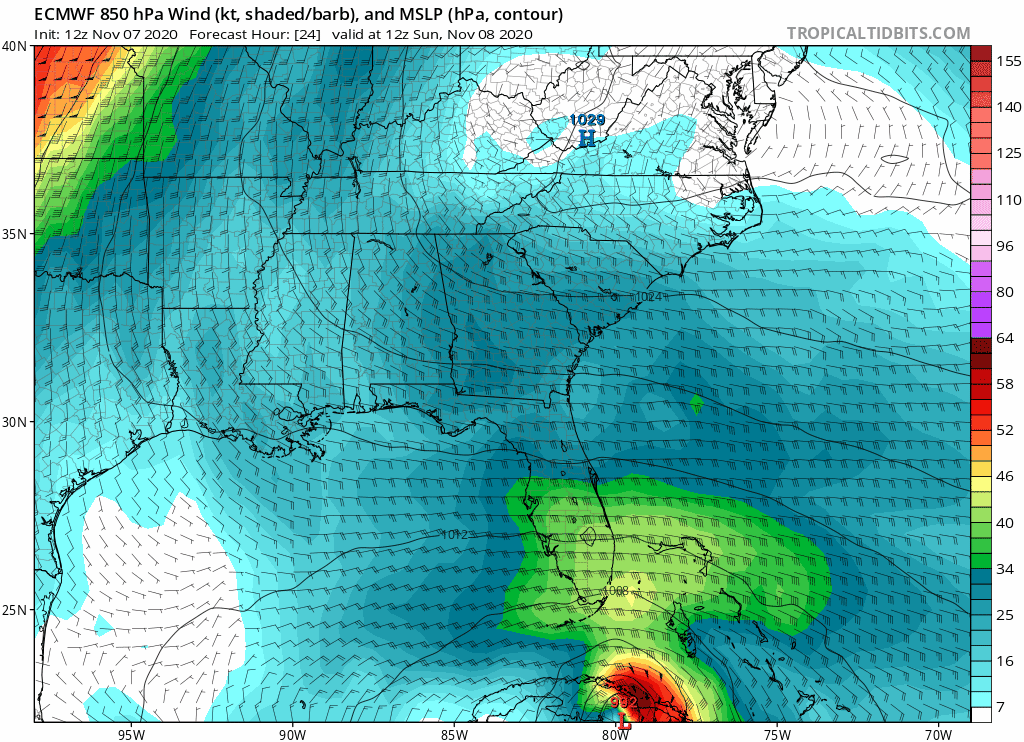
gatorcane wrote::uarrow: Center is irrelevant guys, impacts far from center. Euro 850mb winds don’t look as high over Florida as the GFS though
https://i.postimg.cc/CLxSdcqd/ecmwf-mslp-uv850-seus-fh24-144.gif
https://i.postimg.cc/Bvgm8BDQ/gfs-mslp-uv850-seus-fh24-144.gif
With the way the Euro has performed this season I think I’ll side with the GFS.
1 likes
-
AutoPenalti
- Category 5
- Posts: 4091
- Age: 29
- Joined: Mon Aug 17, 2015 4:16 pm
- Location: Ft. Lauderdale, Florida
Re: ATL: ETA - Models
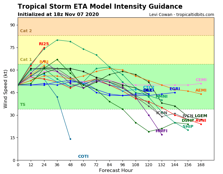
Intensity guidance stronger?
0 likes
The posts in this forum are NOT official forecasts and should not be used as such. They are just the opinion of the poster and may or may not be backed by sound meteorological data. They are NOT endorsed by any professional institution or STORM2K. For official information, please refer to products from the NHC and NWS.
Model Runs Cheat Sheet:
GFS (5:30 AM/PM, 11:30 AM/PM)
HWRF, GFDL, UKMET, NAVGEM (6:30-8:00 AM/PM, 12:30-2:00 AM/PM)
ECMWF (1:45 AM/PM)
TCVN is a weighted averaged
-
TheStormExpert
Re: ATL: ETA - Models
AutoPenalti wrote:
Intensity guidance stronger?
No, it’s just due to current intensity being stronger than initialized at 12z.
0 likes
-
SFLcane

- S2K Supporter
- Posts: 10281
- Age: 48
- Joined: Sat Jun 05, 2010 1:44 pm
- Location: Lake Worth Florida
Re: ATL: ETA - Models
Note that the HWRF & HMON models have been performing the best on track and intensity thus far.
1 likes
-
Spacecoast

- Category 2

- Posts: 773
- Joined: Thu Aug 31, 2017 2:03 pm
Re: ATL: ETA - Models
Day 3 sorted Average Track error (in nm) for Eta:

Day 3 sorted Average Intensity error (kn) for Eta:

Day 2 sorted Average Track error (in nm) for Eta:

Day 2 sorted Average Intensity error (kn) for Eta:

Day 3 sorted Average Intensity error (kn) for Eta:
Day 2 sorted Average Track error (in nm) for Eta:
Day 2 sorted Average Intensity error (kn) for Eta:
2 likes
-
SouthFLTropics

- Category 5
- Posts: 4258
- Age: 50
- Joined: Thu Aug 14, 2003 8:04 am
- Location: Port St. Lucie, Florida
Re: ATL: ETA - Models
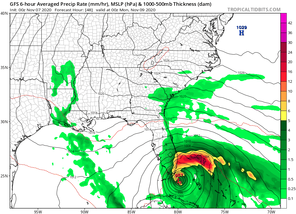
Um, 18z GFS coming in much stronger in the GOM after passing South Florida.
Sent from my iPhone using Tapatalk
Sent from my iPhone using Tapatalk
0 likes
Fourth Generation Florida Native
Personal Storm History: David 79, Andrew 92, Erin 95, Floyd 99, Irene 99, Frances 04, Jeanne 04, Wilma 05, Matthew 16, Irma 17, Ian 22, Nicole 22, Milton 24
Personal Storm History: David 79, Andrew 92, Erin 95, Floyd 99, Irene 99, Frances 04, Jeanne 04, Wilma 05, Matthew 16, Irma 17, Ian 22, Nicole 22, Milton 24
-
SouthFLTropics
- Category 5
- Posts: 4258
- Age: 50
- Joined: Thu Aug 14, 2003 8:04 am
- Location: Port St. Lucie, Florida
Re: ATL: ETA - Models
SouthFLTropics wrote:Um, 18z GFS coming in much stronger in the GOM after passing South Florida.
Sent from my iPhone using Tapatalk

0 likes
Fourth Generation Florida Native
Personal Storm History: David 79, Andrew 92, Erin 95, Floyd 99, Irene 99, Frances 04, Jeanne 04, Wilma 05, Matthew 16, Irma 17, Ian 22, Nicole 22, Milton 24
Personal Storm History: David 79, Andrew 92, Erin 95, Floyd 99, Irene 99, Frances 04, Jeanne 04, Wilma 05, Matthew 16, Irma 17, Ian 22, Nicole 22, Milton 24
-
SouthFLTropics
- Category 5
- Posts: 4258
- Age: 50
- Joined: Thu Aug 14, 2003 8:04 am
- Location: Port St. Lucie, Florida
Re: ATL: ETA - Models
If the 18z GFS is right, this thing is still going to be hanging around in the SE GOM a week from now. That location would favor enhanced training of storms over the peninsula. The rain totals for the next week will be off the chart.
2 likes
Fourth Generation Florida Native
Personal Storm History: David 79, Andrew 92, Erin 95, Floyd 99, Irene 99, Frances 04, Jeanne 04, Wilma 05, Matthew 16, Irma 17, Ian 22, Nicole 22, Milton 24
Personal Storm History: David 79, Andrew 92, Erin 95, Floyd 99, Irene 99, Frances 04, Jeanne 04, Wilma 05, Matthew 16, Irma 17, Ian 22, Nicole 22, Milton 24

-
AdamFirst

- S2K Supporter
- Posts: 2490
- Age: 36
- Joined: Thu Aug 14, 2008 10:54 am
- Location: Port Saint Lucie, FL
Re: ATL: ETA - Models
LOL, TVCN is out to lunch. The computers can't computate that sort of wackiness even if they tried. wxman57 posted a singular plot of the 18z run. Or, Florida's in for a big flooding event over the next 5 days, perhaps
1 likes
Dolphins Marlins Canes Golden Panthers HEAT
Andrew 1992 - Irene 1999 - Frances 2004 - Jeanne 2004 - Wilma 2005 - Fay 2008 - Isaac 2012 - Matthew 2016 - Irma 2017 - Dorian 2019 - Ian 2022 - Nicole 2022 - Milton 2024
Andrew 1992 - Irene 1999 - Frances 2004 - Jeanne 2004 - Wilma 2005 - Fay 2008 - Isaac 2012 - Matthew 2016 - Irma 2017 - Dorian 2019 - Ian 2022 - Nicole 2022 - Milton 2024
-
cycloneye

- Admin

- Posts: 149275
- Age: 69
- Joined: Thu Oct 10, 2002 10:54 am
- Location: San Juan, Puerto Rico
Re: ATL: ETA - Models
0 likes
Visit the Caribbean-Central America Weather Thread where you can find at first post web cams,radars
and observations from Caribbean basin members Click Here
and observations from Caribbean basin members Click Here


Re: ATL: ETA - Models
Seems like most of the models have shifted to having Eta move further SW (closer to the Yucatán Channel) and slowing down at least somewhat. The GFS and HMON put it in the optimal place to become a Cat 2/3, while the HWRF, CMC, and ICON don’t show anything stronger than they’ve previously had over the last multiple runs.
0 likes
Irene '11 Sandy '12 Hermine '16 5/15/2018 Derecho Fay '20 Isaias '20 Elsa '21 Henri '21 Ida '21
I am only a meteorology enthusiast who knows a decent amount about tropical cyclones. Look to the professional mets, the NHC, or your local weather office for the best information.
I am only a meteorology enthusiast who knows a decent amount about tropical cyclones. Look to the professional mets, the NHC, or your local weather office for the best information.
Who is online
Users browsing this forum: No registered users and 115 guests