ATL: ETA - Models

Moderator: S2k Moderators

Message
Author
User avatar
blp
Category 5
Category 5
Posts: 2840
Age: 46
Joined: Thu Sep 09, 2004 7:51 pm
Location: Miami, FL
Contact:

Re: ATL: ETA - Models

#1501 Postby blp » Fri Nov 06, 2020 7:43 pm

SFLcane wrote:
Blown Away wrote:
SFLcane wrote:
Yep, it’s heading north right into SFL. :eek:

https://i.postimg.cc/Sx5BKt0P/67687-FE0-F205-4-E34-9-BCD-23-FA3-C915-EDC.jpg


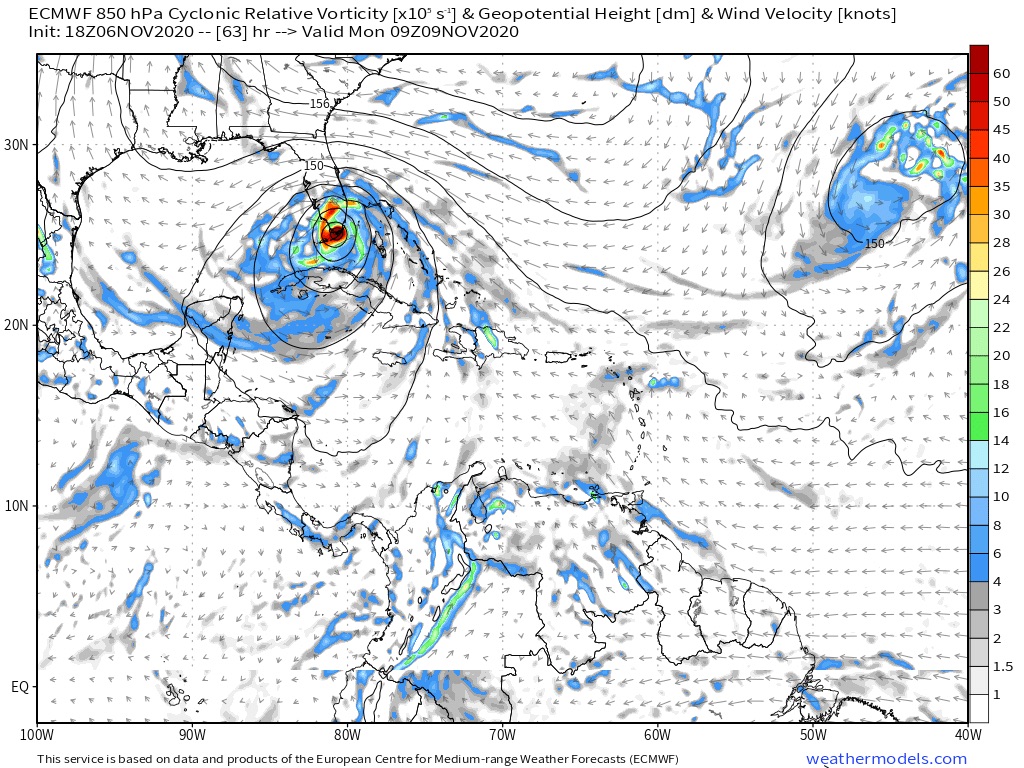
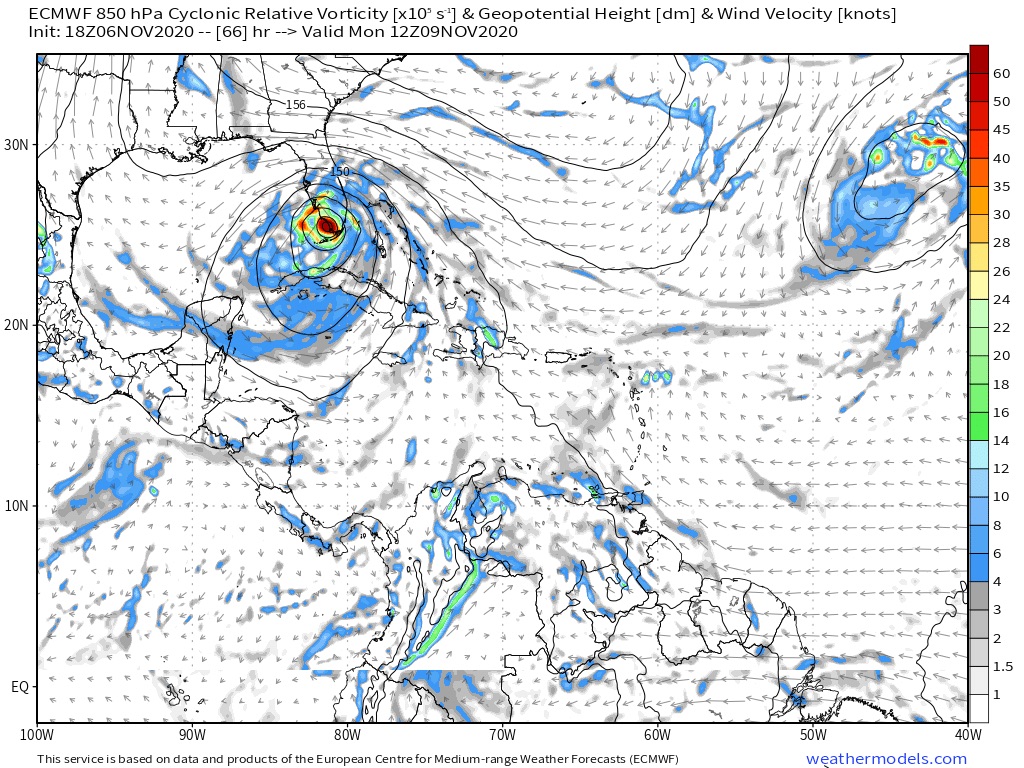
It’s news if it doesn’t go 90 degrees W in next frame... :D


Heads nw across southeast Florida before heading into the GOM. Either way you slice this it’s north of nhc forecast

https://i.postimg.cc/mkHc0nsG/14404061-8025-4950-81-D6-5061-FED5-E2-EA.jpg


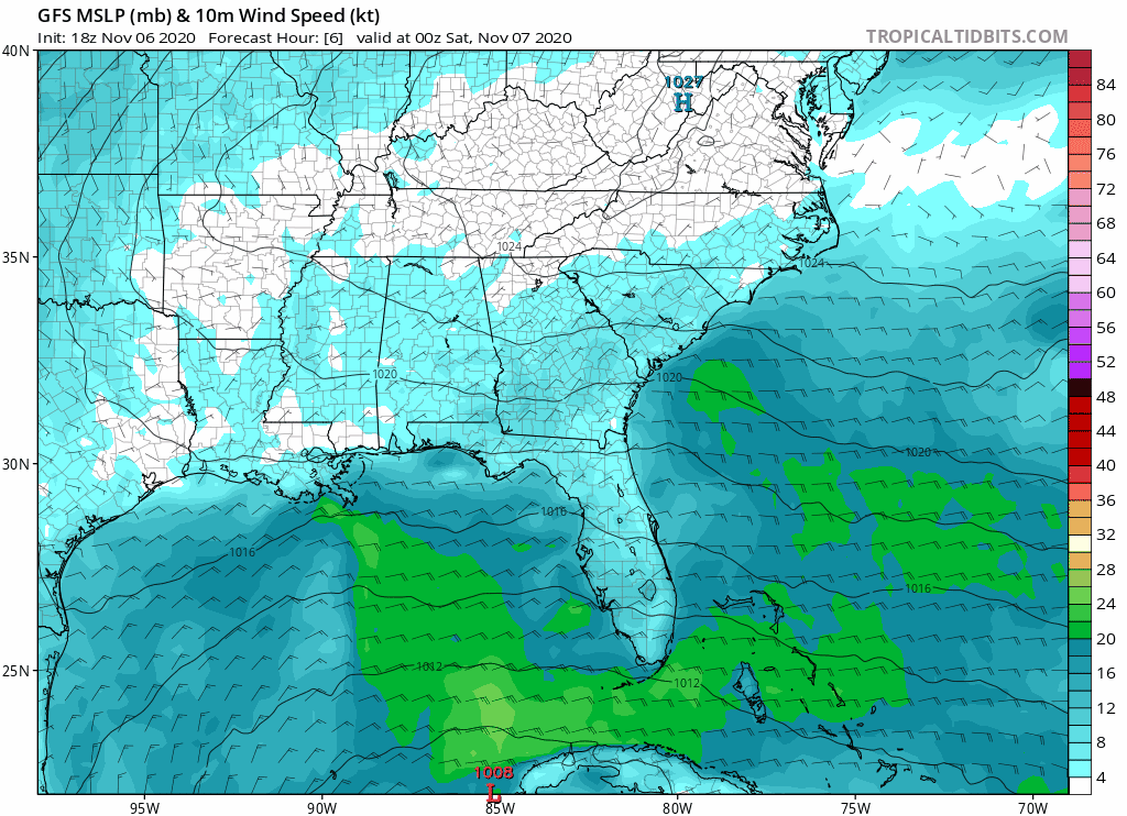
How strong does it have it?
0 likes   
The following post is NOT an official forecast and should not be used as such. It is just the opinion of the poster and may or may not be backed by sound meteorological data. It is NOT endorsed by any professional institution including storm2k.org For Official Information please refer to the NHC and NWS products.

User avatar
SFLcane
S2K Supporter
S2K Supporter
Posts: 10163
Age: 47
Joined: Sat Jun 05, 2010 1:44 pm
Location: Lake Worth Florida

Re: ATL: ETA - Models

#1502 Postby SFLcane » Fri Nov 06, 2020 7:45 pm

00z models shifting north again...

Image
0 likes   

User avatar
Blown Away
S2K Supporter
S2K Supporter
Posts: 10145
Joined: Wed May 26, 2004 6:17 am

Re: ATL: ETA - Models

#1503 Postby Blown Away » Fri Nov 06, 2020 8:13 pm


The only way that left bump flattens is if Eta moves faster and south of the NHC track over next 36 hours. Which could happen.
0 likes   
Hurricane Eye Experience: David 79, Irene 99, Frances 04, Jeanne 04, Wilma 05... EYE COMING MY WAY IN 2024…
Hurricane Brush Experience: Andrew 92, Erin 95, Floyd 99, Matthew 16, Irma 17, Ian 22, Nicole 22…

User avatar
gatorcane
S2K Supporter
S2K Supporter
Posts: 23691
Age: 47
Joined: Sun Mar 13, 2005 3:54 pm
Location: Boca Raton, FL

Re: ATL: ETA - Models

#1504 Postby gatorcane » Fri Nov 06, 2020 8:21 pm

00Z guidance:

Image
Image
0 likes   

User avatar
boca
Category 5
Category 5
Posts: 6367
Age: 60
Joined: Mon Dec 15, 2003 8:49 am
Location: Boca Raton,FL

Re: ATL: ETA - Models

#1505 Postby boca » Fri Nov 06, 2020 8:23 pm

Blown Away wrote:


The only way that left bump flattens is if Eta moves faster and south of the NHC track over next 36 hours. Which could happen.


Are you saying a gradual turn as opposed to what the NHC is predicting with the turn west.
0 likes   

User avatar
gatorcane
S2K Supporter
S2K Supporter
Posts: 23691
Age: 47
Joined: Sun Mar 13, 2005 3:54 pm
Location: Boca Raton, FL

Re: ATL: ETA - Models

#1506 Postby gatorcane » Fri Nov 06, 2020 8:58 pm

The GFS has the heaviest rainfall over the Bahamas with a strip of 6-7 inches over SE Florida

Image
1 likes   

User avatar
gatorcane
S2K Supporter
S2K Supporter
Posts: 23691
Age: 47
Joined: Sun Mar 13, 2005 3:54 pm
Location: Boca Raton, FL

Re: ATL: ETA - Models

#1507 Postby gatorcane » Fri Nov 06, 2020 9:04 pm

The important thing when looking at the model tracks is that impacts will be felt far from the center. Take a look at the GFS which shows the pressure gradient tightening starting tomorrow morning across the east coast of Florida so east winds will be picking up yet the storm will be south of Cuba. I do think the gusts could get pretty wild along the coast over the next few days particularly Sun and into Monday. Looks how the high winds are even are up across the coast of NE Florida on the model.

Image
6 likes   

User avatar
blp
Category 5
Category 5
Posts: 2840
Age: 46
Joined: Thu Sep 09, 2004 7:51 pm
Location: Miami, FL
Contact:

Re: ATL: ETA - Models

#1508 Postby blp » Fri Nov 06, 2020 10:18 pm

Icon coming in much stronger and further north.

Image
0 likes   
The following post is NOT an official forecast and should not be used as such. It is just the opinion of the poster and may or may not be backed by sound meteorological data. It is NOT endorsed by any professional institution including storm2k.org For Official Information please refer to the NHC and NWS products.

User avatar
gatorcane
S2K Supporter
S2K Supporter
Posts: 23691
Age: 47
Joined: Sun Mar 13, 2005 3:54 pm
Location: Boca Raton, FL

Re: ATL: ETA - Models

#1509 Postby gatorcane » Fri Nov 06, 2020 10:49 pm

00Z GFS 6MB stronger into South Florida now 987MB
0 likes   

User avatar
SFLcane
S2K Supporter
S2K Supporter
Posts: 10163
Age: 47
Joined: Sat Jun 05, 2010 1:44 pm
Location: Lake Worth Florida

Re: ATL: ETA - Models

#1510 Postby SFLcane » Fri Nov 06, 2020 10:50 pm

00z Gfs much stronger! 986mb

Also tracks NW into the state

Image
Last edited by SFLcane on Fri Nov 06, 2020 10:53 pm, edited 3 times in total.
0 likes   

TheStormExpert

Re: ATL: ETA - Models

#1511 Postby TheStormExpert » Fri Nov 06, 2020 10:50 pm

gatorcane wrote:00Z GFS 6MB stronger into South Florida now 987MB

It’s actually only 2mb stronger when compared to 18z.
0 likes   

AutoPenalti
Category 5
Category 5
Posts: 4030
Age: 29
Joined: Mon Aug 17, 2015 4:16 pm
Location: Ft. Lauderdale, Florida

Re: ATL: ETA - Models

#1512 Postby AutoPenalti » Fri Nov 06, 2020 10:56 pm

TheStormExpert wrote:
gatorcane wrote:00Z GFS 6MB stronger into South Florida now 987MB

It’s actually only 2mb stronger when compared to 18z.

993-987 = 6.
2 likes   
The posts in this forum are NOT official forecasts and should not be used as such. They are just the opinion of the poster and may or may not be backed by sound meteorological data. They are NOT endorsed by any professional institution or STORM2K. For official information, please refer to products from the NHC and NWS.


Model Runs Cheat Sheet:
GFS (5:30 AM/PM, 11:30 AM/PM)
HWRF, GFDL, UKMET, NAVGEM (6:30-8:00 AM/PM, 12:30-2:00 AM/PM)
ECMWF (1:45 AM/PM)

TCVN
is a weighted averaged

caneseddy
Category 5
Category 5
Posts: 1172
Joined: Fri Sep 03, 2004 9:31 pm
Location: Plantation, FL

Re: ATL: ETA - Models

#1513 Postby caneseddy » Fri Nov 06, 2020 10:57 pm

TheStormExpert wrote:
gatorcane wrote:00Z GFS 6MB stronger into South Florida now 987MB

It’s actually only 2mb stronger when compared to 18z.


Point is that the GFS is trending with a possible stronger storm. Katrina was 985 when she landfalled in South Florida with 80 mph winds and it was no joke.

Also Icon trended stronger; prior to this run it was showing pressures in the low 1000s; now it’s in the 990s.

Trend so far has been lower pressures, albeit slowly.
2 likes   

User avatar
toad strangler
S2K Supporter
S2K Supporter
Posts: 4543
Joined: Sun Jul 28, 2013 3:09 pm
Location: Earth
Contact:

Re: ATL: ETA - Models

#1514 Postby toad strangler » Fri Nov 06, 2020 10:59 pm

SFLcane wrote:00z Gfs much stronger! 986mb

Also tracks NW into the state

https://i.imgur.com/G32WXB6.png


The vort signature on the 0z GFS looks quite impressive all things considered.
3 likes   

User avatar
SFLcane
S2K Supporter
S2K Supporter
Posts: 10163
Age: 47
Joined: Sat Jun 05, 2010 1:44 pm
Location: Lake Worth Florida

Re: ATL: ETA -

#1515 Postby SFLcane » Fri Nov 06, 2020 11:01 pm

toad strangler wrote:
SFLcane wrote:00z Gfs much stronger! 986mb

Also tracks NW into the state

https://i.imgur.com/G32WXB6.png


The vort signature on the 0z GFS looks quite impressive all things considered.


Hopefully this isn’t a sign the 00z runs will be stronger. All things considered I am expecting further northward track shifts and hurricane watches tomorrow.
0 likes   

caneseddy
Category 5
Category 5
Posts: 1172
Joined: Fri Sep 03, 2004 9:31 pm
Location: Plantation, FL

Re: ATL: ETA - Models

#1516 Postby caneseddy » Fri Nov 06, 2020 11:03 pm

toad strangler wrote:
SFLcane wrote:00z Gfs much stronger! 986mb

Also tracks NW into the state

https://i.imgur.com/G32WXB6.png


The vort signature on the 0z GFS looks quite impressive all things considered.


Looks like going over Cuba tightens it up, which was what the HWRF showed in its earlier run
0 likes   

TheStormExpert

Re: ATL: ETA - Models

#1517 Postby TheStormExpert » Fri Nov 06, 2020 11:13 pm

Definitely not much left near the center of Eta at landfall in SE Florida on the 00z GFS. As gatorcane keeps saying, this storm will be highly sheared and the effects will be felt several hundred miles away from the center.

Image
0 likes   

User avatar
ElectricStorm
Category 5
Category 5
Posts: 5042
Age: 24
Joined: Tue Aug 13, 2019 11:23 pm
Location: Skiatook, OK / Norman, OK

Re: ATL: ETA - Models

#1518 Postby ElectricStorm » Sat Nov 07, 2020 12:14 am

0z HWRF has a Cat 1 into Cuba followed by a Cat 1 into SE FL.
So does HMON
0 likes   
B.S Meteorology, University of Oklahoma '25

Please refer to the NHC, NWS, or SPC for official information.

AutoPenalti
Category 5
Category 5
Posts: 4030
Age: 29
Joined: Mon Aug 17, 2015 4:16 pm
Location: Ft. Lauderdale, Florida

Re: ATL: ETA - Models

#1519 Postby AutoPenalti » Sat Nov 07, 2020 12:32 am

Weather Dude wrote:0z HWRF has a Cat 1 into Cuba followed by a Cat 1 into SE FL.
So does HMON

Weaker.
0 likes   
The posts in this forum are NOT official forecasts and should not be used as such. They are just the opinion of the poster and may or may not be backed by sound meteorological data. They are NOT endorsed by any professional institution or STORM2K. For official information, please refer to products from the NHC and NWS.


Model Runs Cheat Sheet:
GFS (5:30 AM/PM, 11:30 AM/PM)
HWRF, GFDL, UKMET, NAVGEM (6:30-8:00 AM/PM, 12:30-2:00 AM/PM)
ECMWF (1:45 AM/PM)

TCVN
is a weighted averaged

User avatar
SFLcane
S2K Supporter
S2K Supporter
Posts: 10163
Age: 47
Joined: Sat Jun 05, 2010 1:44 pm
Location: Lake Worth Florida

Re: ATL: ETA - Models

#1520 Postby SFLcane » Sat Nov 07, 2020 5:08 am

06z gfs 987mb into dade county.
0 likes   


Return to “2020”

Who is online

Users browsing this forum: No registered users and 8 guests