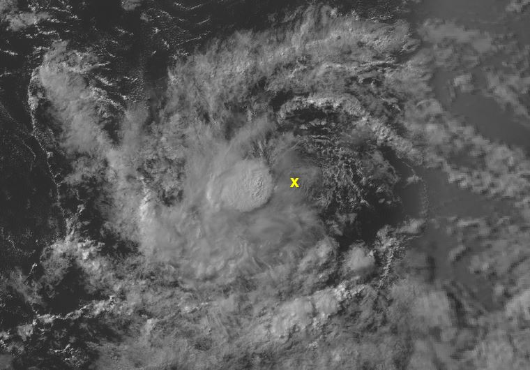
What was the LLC currently looks stretched out. Looks like it might be getting sucked under the convective blob. IDK either that circ will have to redefine itself or a new circ will have to take over under the convection for this to get classified I think. But it has time I think we get Josephine out of this
https://tropicaltidbits.com/sat/satloop ... t=vis-swir
ATL: JOSEPHINE - Remnants - Discussion
Moderator: S2k Moderators
-
HurricaneEnzo

- Category 2

- Posts: 744
- Joined: Wed Mar 14, 2018 12:18 pm
- Location: Newport, NC (Hurricane Alley)
Re: ATL: INVEST 95L - Discussion
3 likes
Bertha 96' - Fran 96' - Bonnie 98' - Dennis 99' - Floyd 99' - Isabel 03' - Alex 04' - Ophelia 05' - Irene 11' - Arthur 14' - Matthew 16' - Florence 18' - Dorian 19' - Isaias 20' (countless other tropical storms and Hurricane swipes)
I am not a Professional Met just an enthusiast. Get your weather forecasts from the Pros!
I am not a Professional Met just an enthusiast. Get your weather forecasts from the Pros!

Re: ATL: INVEST 95L - Discussion
90/90 in the latest TWO! The NHC says that advisories on a TD could be initiated later today if its organizational trend continues.
4 likes
Irene '11 Sandy '12 Hermine '16 5/15/2018 Derecho Fay '20 Isaias '20 Elsa '21 Henri '21 Ida '21
I am only a meteorology enthusiast who knows a decent amount about tropical cyclones. Look to the professional mets, the NHC, or your local weather office for the best information.
I am only a meteorology enthusiast who knows a decent amount about tropical cyclones. Look to the professional mets, the NHC, or your local weather office for the best information.

Re: ATL: INVEST 95L - Discussion
06Z GFS forecasting dry-air entrainment to begin in about 50 hrs.
We will see how well this is a protected pouch then.
It'll depend on mesoscale effects which GFS can't effectively model due to spatial-resolution limitations.
We will see how well this is a protected pouch then.
It'll depend on mesoscale effects which GFS can't effectively model due to spatial-resolution limitations.
2 likes
-
cycloneye

- Admin

- Posts: 149840
- Age: 69
- Joined: Thu Oct 10, 2002 10:54 am
- Location: San Juan, Puerto Rico
Re: ATL: INVEST 95L - Discussion
2 likes
Visit the Caribbean-Central America Weather Thread where you can find at first post web cams,radars
and observations from Caribbean basin members Click Here
and observations from Caribbean basin members Click Here
Re: ATL: INVEST 95L - Discussion
50 hrs out, GFS shows UL winds abating due to Anticyclone Wave Break directly to its north.
TUTT farther away to the NE.
Strengthens then as the anticyclone moves over the CoC.
Watching closely how well this protects itself from SAL.


TUTT farther away to the NE.
Strengthens then as the anticyclone moves over the CoC.
Watching closely how well this protects itself from SAL.
3 likes
Re: ATL: INVEST 95L - Discussion
Too far out to call what may happen in the Bahamas come early next week.
There are indications something may develop off the east coast then due to a stalled front.
The whole dynamics of the forecast will be dramatically altered if that happens.
There are indications something may develop off the east coast then due to a stalled front.
The whole dynamics of the forecast will be dramatically altered if that happens.
3 likes

Re: ATL: INVEST 95L - Discussion
That convection is fool's gold. No upgrade until at least tomorrow AM. It needs to rebuild
4 likes
-
MarioProtVI
- Category 5

- Posts: 1039
- Age: 24
- Joined: Sun Sep 29, 2019 7:33 pm
- Location: New Jersey
Re: ATL: INVEST 95L - Discussion
I think that’s the old LLC dying with a new one developing underneath. But the waning convection has me a bit skeptical. Not sure we see 11L at 11
3 likes
-
OuterBanker
- S2K Supporter

- Posts: 1761
- Joined: Wed Feb 26, 2003 10:53 am
- Location: Nags Head, NC
- Contact:
Re: ATL: INVEST 95L - Discussion
OuterBanker wrote:20% is too generous I think. Next Sunday maybe. Let's enjoy the lull this week. The real season begins next week. It will be a hum dinger I'm afraid.
I understand crow is best served fried.
6 likes
-
wxman57

- Moderator-Pro Met

- Posts: 23177
- Age: 68
- Joined: Sat Jun 21, 2003 8:06 pm
- Location: Houston, TX (southwest)
Re: ATL: INVEST 95L - Discussion
MarioProtVI wrote:
I think that’s the old LLC dying with a new one developing underneath. But the waning convection has me a bit skeptical. Not sure we see 11L at 11
I agree that LLC has no future, but I don't see a new one developing. Not much of a future for this disturbance.
0 likes
Re: ATL: INVEST 95L - Discussion
IMHO there is enough convective debris to pinch off SAL, enough LL vort, enough warm core, and enough TPW infeed to get this to start pulsing.
Watching if the next pulse, if and when that may occur, will be closer to the CoC.
Watching if the next pulse, if and when that may occur, will be closer to the CoC.
0 likes
-
Hurricaneman

- Category 5
- Posts: 7404
- Age: 45
- Joined: Tue Aug 31, 2004 3:24 pm
- Location: central florida
Re: ATL: INVEST 95L - Discussion
Sounds like Alex doesn’t want to wait until after the 20th but that’s looking like reality as this will die out due to SAL and mjo stability
0 likes
-
TheStormExpert
-
cycloneye
- Admin
- Posts: 149840
- Age: 69
- Joined: Thu Oct 10, 2002 10:54 am
- Location: San Juan, Puerto Rico
Re: ATL: INVEST 95L - Discussion
AL, 95, 2020081112, , BEST, 0, 113N, 382W, 30, 1007, LO, 0, , 0, 0, 0, 0, 1011, 150, 40, 0, 0, L, 0, , 0, 0, INVEST, M
At 1200 UTC, 11 August 2020, LOW INVEST 95 (AL95) was located in the North Atlantic basin at 11.3°N and 38.2°W. The current intensity was 30 kt and the center was moving at 14 kt at a bearing of 275 degrees. The minimum central pressure was 1007 mb.
At 1200 UTC, 11 August 2020, LOW INVEST 95 (AL95) was located in the North Atlantic basin at 11.3°N and 38.2°W. The current intensity was 30 kt and the center was moving at 14 kt at a bearing of 275 degrees. The minimum central pressure was 1007 mb.
2 likes
Visit the Caribbean-Central America Weather Thread where you can find at first post web cams,radars
and observations from Caribbean basin members Click Here
and observations from Caribbean basin members Click Here
-
TheStormExpert
-
plasticup
Re: ATL: INVEST 95L - Discussion
Gotta satisfy that "hyperactive" prediction! 2005 was like that too - every little wisp with some spin was given a name. There were 3-4 "Tropical Storms" that lasted <24 hours.
0 likes
Re: ATL: INVEST 95L - Discussion
Looks like the LL Center is east of the 700mb wave peak.
It appears the two will align in 24 hrs.
This is currently SE of an Antycyclonic Wave Break.
The AWB is forecast to move south somewhat in the next 24 hrs as the CoC gets directly south of it.
This should improve chances for development as long as this can stay protected from SAL.
It appears the two will align in 24 hrs.
This is currently SE of an Antycyclonic Wave Break.
The AWB is forecast to move south somewhat in the next 24 hrs as the CoC gets directly south of it.
This should improve chances for development as long as this can stay protected from SAL.
1 likes
-
wxman57
- Moderator-Pro Met
- Posts: 23177
- Age: 68
- Joined: Sat Jun 21, 2003 8:06 pm
- Location: Houston, TX (southwest)
Re: ATL: INVEST 95L - Discussion
plasticup wrote:
Gotta satisfy that "hyperactive" prediction! 2005 was like that too - every little wisp with some spin was given a name. There were 3-4 "Tropical Storms" that lasted <24 hours.
I would not accuse the NHC of falsely trying to pump up the numbers. However, the requirements for what qualifies as a named storm have changed significantly during my 40+ years as a hurricane forecaster.
10 likes
-
toad strangler

- S2K Supporter
- Posts: 4546
- Joined: Sun Jul 28, 2013 3:09 pm
- Location: Earth
- Contact:
Re: ATL: INVEST 95L - Discussion
wxman57 wrote:plasticup wrote:
Gotta satisfy that "hyperactive" prediction! 2005 was like that too - every little wisp with some spin was given a name. There were 3-4 "Tropical Storms" that lasted <24 hours.
I would not accuse the NHC of falsely trying to pump up the numbers. However, the requirements for what qualifies as a named storm have changed significantly during my 40+ years as a hurricane forecaster.
The ability of obtaining the qualifying data has changed as well I'd confidently assume. I guess looks can be deceiving? I dunno....
6 likes
My Weather Station
https://www.wunderground.com/dashboard/pws/KFLPORTS603
https://www.wunderground.com/dashboard/pws/KFLPORTS603
Who is online
Users browsing this forum: No registered users and 109 guests