ATL: ISAIAS - Post-Tropical - Discussion

Moderator: S2k Moderators

Message
Author
Shell Mound
Category 5
Category 5
Posts: 2434
Age: 32
Joined: Thu Sep 07, 2017 3:39 pm
Location: St. Petersburg, FL → Scandinavia

Re: ATL: INVEST 92L - Discussion

#141 Postby Shell Mound » Sun Jul 26, 2020 10:43 am

aspen wrote:Since the GFS and Euro have been so bad with the development of Gonzalo and Hanna, and those issues definitely won’t magically correct themselves for 92L just days afterwards, it’s probably likely that the actual future of 92L will be very different. Two broad possibilities seem the most plausible:

1.) the complete opposite of Gonzalo and Hanna happens — 92L fails to develop despite strong model support and either rams into the Greater Antilles or becomes Gonzalo 2.0, gulping SAL and limping its way to its deathbed.

2.) 92L exceeds expectations and becomes a stronger system than any of the models were anticipating, either on the same track they’re now showing or on a Caribbean Cruiser track.

Given the conservative bias of the EPS/ECMWF and the G(E)FS thus far, option two seems far more plausible than option one at this stage.

To be fair, however, you shouldn’t necessarily say “any of the models.” The UKMET and CMC have been fairly bullish with 92L/Isaias.
4 likes   
CVW / MiamiensisWx / Shell Mound
The posts in this forum are NOT official forecasts and should not be used as such. They are just the opinion of the poster and may or may not be backed by sound meteorological data. They are NOT endorsed by any professional institution or STORM2K. For official information, please refer to products from the NHC and NWS.

User avatar
DestinHurricane
Category 4
Category 4
Posts: 935
Joined: Tue May 01, 2018 8:05 am
Location: New York, NY

Re: ATL: INVEST 92L - Discussion

#142 Postby DestinHurricane » Sun Jul 26, 2020 11:09 am

Here's what i'm thinking this far out, though i'm no pro met.

50% - only affects islands. No CONUS landfall
15% - Landfall or scrapes the NE
15% - North Carolina
10% - Northeast FL to S Carolina
5% FL south of cape Canaveral
5% Gulf
1 likes   
Michael 2018

User avatar
gatorcane
S2K Supporter
S2K Supporter
Posts: 23691
Age: 47
Joined: Sun Mar 13, 2005 3:54 pm
Location: Boca Raton, FL

Re: ATL: INVEST 92L - Discussion

#143 Postby gatorcane » Sun Jul 26, 2020 11:20 am

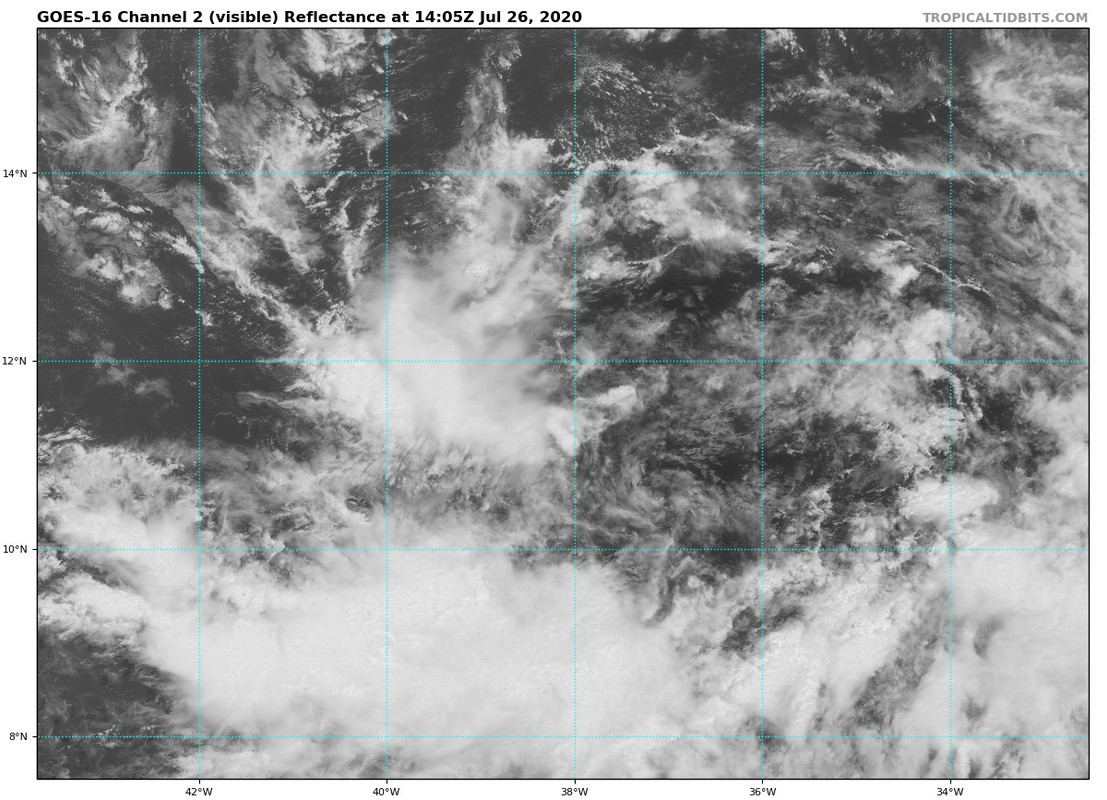
92l continues to look more disorganized as SAL and the fast forward speed take its toll. Wouldn’t be surprised if models start becoming more bearish on this but of course at some point down the road, it could find more favorable conditions so we watch and wait:

Image
Last edited by gatorcane on Sun Jul 26, 2020 11:23 am, edited 2 times in total.
2 likes   

User avatar
aspen
Category 5
Category 5
Posts: 8818
Joined: Sat Oct 12, 2019 7:10 pm
Location: Connecticut, USA

Re: ATL: INVEST 92L - Discussion

#144 Postby aspen » Sun Jul 26, 2020 11:22 am

Shell Mound wrote:
aspen wrote:Since the GFS and Euro have been so bad with the development of Gonzalo and Hanna, and those issues definitely won’t magically correct themselves for 92L just days afterwards, it’s probably likely that the actual future of 92L will be very different. Two broad possibilities seem the most plausible:

1.) the complete opposite of Gonzalo and Hanna happens — 92L fails to develop despite strong model support and either rams into the Greater Antilles or becomes Gonzalo 2.0, gulping SAL and limping its way to its deathbed.

2.) 92L exceeds expectations and becomes a stronger system than any of the models were anticipating, either on the same track they’re now showing or on a Caribbean Cruiser track.

Given the conservative bias of the EPS/ECMWF and the G(E)FS thus far, option two seems far more plausible than option one at this stage.

To be fair, however, you shouldn’t necessarily say “any of the models.” The UKMET and CMC have been fairly bullish with 92L/Isaias.

What I mean by “more I tense than any of the models are showing” is 92L/Isaias finding a sweet spot to bomb out into a Cat 4 (conditions are not good enough for a Cat 5 at this time). The strongest models so far show a Cat 2/3.
0 likes   
Irene '11 Sandy '12 Hermine '16 5/15/2018 Derecho Fay '20 Isaias '20 Elsa '21 Henri '21 Ida '21

I am only a meteorology enthusiast who knows a decent amount about tropical cyclones. Look to the professional mets, the NHC, or your local weather office for the best information.

User avatar
SFLcane
S2K Supporter
S2K Supporter
Posts: 10163
Age: 47
Joined: Sat Jun 05, 2010 1:44 pm
Location: Lake Worth Florida

Re: ATL: INVEST 92L - Discussion

#145 Postby SFLcane » Sun Jul 26, 2020 12:17 pm

Wow 70-90% now!


A broad area of low pressure located over the central tropical Atlantic continues to produce a wide area of disorganized showers and thunderstorms as it moves westward around 20 mph. Environmental conditions are forecast to be conducive for development and a
tropical depression or tropical storm is likely to form within the
next two or three days as the system nears the Lesser Antilles.
Interests in the Lesser Antilles should monitor the progress of this
system.
* Formation chance through 48 hours...high...70 percent.
* Formation chance through 5 days...high...90 percent.

$$
2 likes   

User avatar
HurricaneAndre2008
Category 1
Category 1
Posts: 334
Age: 27
Joined: Wed Jul 31, 2019 9:51 pm
Contact:

Re: ATL: INVEST 92L - Discussion

#146 Postby HurricaneAndre2008 » Sun Jul 26, 2020 12:18 pm

412
ABNT20 KNHC 261714
TWOAT

Tropical Weather Outlook
NWS National Hurricane Center Miami FL
200 PM EDT Sun Jul 26 2020

For the North Atlantic...Caribbean Sea and the Gulf of Mexico:

The National Hurricane Center is issuing advisories on Tropical
Storm Hanna, located inland over northeast Mexico.

A broad area of low pressure located over the central tropical
Atlantic continues to produce a wide area of disorganized showers
and thunderstorms as it moves westward around 20 mph. Environmental
conditions are forecast to be conducive for development and a
tropical depression or tropical storm is likely to form within the
next two or three days as the system nears the Lesser Antilles.
Interests in the Lesser Antilles should monitor the progress of this
system.
* Formation chance through 48 hours...high...70 percent.
* Formation chance through 5 days...high...90 percent.

$$
Forecaster Zelinsky
2 likes   
Cindy(2005), Katrina(2005), Rita(2005), Erin(2007), Isaac(2012)

TheStormExpert

Re: ATL: INVEST 92L - Discussion

#147 Postby TheStormExpert » Sun Jul 26, 2020 12:20 pm

:uarrow: I mean a Tropical Depression or Storm is likely to form but a hurricane might be a long shot just going off the current 12z model suite.
2 likes   

User avatar
abajan
S2K Supporter
S2K Supporter
Posts: 4230
Joined: Sun Sep 07, 2003 5:10 am
Location: Barbados

Re: ATL: INVEST 92L - Discussion

#148 Postby abajan » Sun Jul 26, 2020 12:22 pm

gatorcane wrote:92l continues to look more disorganized as SAL and the fast forward speed take its toll. Wouldn’t be surprised if models start becoming more bearish on this but of course at some point down the road, it could find more favorable conditions so we watch and wait:

https://i.postimg.cc/HsdbBwyS/goes16-vis-92-L-202007261405-lat11-5-lon323-1.jpg

Looks like at least one of the centers of circulation is visible in that image: near 10.7N 37.0W. But I don't know whether it's a low level one or not.
0 likes   

User avatar
toad strangler
S2K Supporter
S2K Supporter
Posts: 4543
Joined: Sun Jul 28, 2013 3:09 pm
Location: Earth
Contact:

Re: ATL: INVEST 92L - Discussion

#149 Postby toad strangler » Sun Jul 26, 2020 12:24 pm

gatorcane wrote:92l continues to look more disorganized as SAL and the fast forward speed take its toll. Wouldn’t be surprised if models start becoming more bearish on this but of course at some point down the road, it could find more favorable conditions so we watch and wait:

https://i.postimg.cc/HsdbBwyS/goes16-vis-92-L-202007261405-lat11-5-lon323-1.jpg


Disagree, that's a healthy juicy wave waiting for a spark. Look at the rotation.
http://www.tropicaltidbits.com/sat/satlooper.php?region=92L&product=truecolor
10 likes   

User avatar
chaser1
S2K Supporter
S2K Supporter
Posts: 5464
Age: 64
Joined: Sat Oct 15, 2005 5:59 pm
Location: Longwood, Fl

Re: ATL: INVEST 92L - Discussion

#150 Postby chaser1 » Sun Jul 26, 2020 12:46 pm

abajan wrote:
gatorcane wrote:92l continues to look more disorganized as SAL and the fast forward speed take its toll. Wouldn’t be surprised if models start becoming more bearish on this but of course at some point down the road, it could find more favorable conditions so we watch and wait:

https://i.postimg.cc/HsdbBwyS/goes16-vis-92-L-202007261405-lat11-5-lon323-1.jpg

Looks like at least one of the centers of circulation is visible in that image: near 10.7N 37.0W. But I don't know whether it's a low level one or not.


You're seeing that correctly though that low level swirl will spin itself out just as the one previous to it did. Appears that another LLC might be attempting to be the dominant around 11N and 39W. What appears to be occurring is that the large mid level circulation is chugging off to the west at a pretty good clip leaving any low level center attempting to stack underneath, to spin out from under the overall envelope due to difficulty to maintain any consistent convection and surface pressure drop to allow a vertical structure to better develop. Dryer air due to SAL is probably a contributing factor however it would appear that NHC anticipates those conditions to soon improve significantly. My concern is that the further west 92L tracks prior to developing, the greater the threat to the Lesser & Greater Antilles and potentially points west thereafter.
5 likes   
Andy D

(For official information, please refer to the NHC and NWS products.)

User avatar
wxman57
Moderator-Pro Met
Moderator-Pro Met
Posts: 22977
Age: 67
Joined: Sat Jun 21, 2003 8:06 pm
Location: Houston, TX (southwest)

Re: ATL: INVEST 92L - Discussion

#151 Postby wxman57 » Sun Jul 26, 2020 12:46 pm

I don't expect it to do much for the next couple of days due to its very fast west movement. Should be a TD by Wednesday and a TS as it enters the NE Caribbean Wednesday night. Near the Bahamas next Fri/Sat, quite possibly as a hurricane. Beyond then, who knows? Models indicate a trof off the East U.S. Coast next weekend. If it's stronger, it could be steered north, missing the US to the east. For now, I'd put my money on a Carolinas hit early next week. Way too far out and very low confidence on that forecast, though. I think if it's slower to develop and is weaker, then a more westerly track, which could take it to the NW Caribbean in 7-8 days.
22 likes   

User avatar
chaser1
S2K Supporter
S2K Supporter
Posts: 5464
Age: 64
Joined: Sat Oct 15, 2005 5:59 pm
Location: Longwood, Fl

Re: ATL: INVEST 92L - Discussion

#152 Postby chaser1 » Sun Jul 26, 2020 12:52 pm

toad strangler wrote:
gatorcane wrote:92l continues to look more disorganized as SAL and the fast forward speed take its toll. Wouldn’t be surprised if models start becoming more bearish on this but of course at some point down the road, it could find more favorable conditions so we watch and wait:

https://i.postimg.cc/HsdbBwyS/goes16-vis-92-L-202007261405-lat11-5-lon323-1.jpg


Disagree, that's a healthy juicy wave waiting for a spark. Look at the rotation.
http://www.tropicaltidbits.com/sat/satlooper.php?region=92L&product=truecolor


Can't argue with what the eyes can plainly see however this season has shown us that "road-kill" will essentially spin up in the Atlantic if given the right opportunity and set of conditions. I think this is just too pronounced of a system for it to fully degenerate and never develop. I have to think that it's more a matter of "when and where" then "if".
7 likes   
Andy D

(For official information, please refer to the NHC and NWS products.)

jlauderdal
S2K Supporter
S2K Supporter
Posts: 7182
Joined: Wed May 19, 2004 5:46 am
Location: NE Fort Lauderdale
Contact:

Re: RE: Re: ATL: INVEST 92L - Discussion

#153 Postby jlauderdal » Sun Jul 26, 2020 1:00 pm

wxman57 wrote:I don't expect it to do much for the next couple of days due to its very fast west movement. Should be a TD by Wednesday and a TS as it enters the NE Caribbean Wednesday night. Near the Bahamas next Fri/Sat, quite possibly as a hurricane. Beyond then, who knows? Models indicate a trof off the East U.S. Coast next weekend. If it's stronger, it could be steered north, missing the US to the east. For now, I'd put my money on a Carolinas hit early next week. Way too far out and very low confidence on that forecast, though. I think if it's slower to develop and is weaker, then a more westerly track, which could take it to the NW Caribbean in 7-8 days.
You make far too much sense for this board...im with you on the development schedule... I do think it gets farther the west than some of the experts on the model thread have it going

Sent from my SM-G973U using Tapatalk
3 likes   

User avatar
HurricaneAndre2008
Category 1
Category 1
Posts: 334
Age: 27
Joined: Wed Jul 31, 2019 9:51 pm
Contact:

Re: ATL: INVEST 92L - Discussion

#154 Postby HurricaneAndre2008 » Sun Jul 26, 2020 1:27 pm

They are writing off 92L on wunderground. Lol
0 likes   
Cindy(2005), Katrina(2005), Rita(2005), Erin(2007), Isaac(2012)

User avatar
chaser1
S2K Supporter
S2K Supporter
Posts: 5464
Age: 64
Joined: Sat Oct 15, 2005 5:59 pm
Location: Longwood, Fl

Re: RE: Re: ATL: INVEST 92L - Discussion

#155 Postby chaser1 » Sun Jul 26, 2020 1:32 pm

jlauderdal wrote:
wxman57 wrote:I don't expect it to do much for the next couple of days due to its very fast west movement. Should be a TD by Wednesday and a TS as it enters the NE Caribbean Wednesday night. Near the Bahamas next Fri/Sat, quite possibly as a hurricane. Beyond then, who knows? Models indicate a trof off the East U.S. Coast next weekend. If it's stronger, it could be steered north, missing the US to the east. For now, I'd put my money on a Carolinas hit early next week. Way too far out and very low confidence on that forecast, though. I think if it's slower to develop and is weaker, then a more westerly track, which could take it to the NW Caribbean in 7-8 days.
You make far too much sense for this board...im with you on the development schedule... I do think it gets farther the west than some of the experts on the model thread have it going

Sent from my SM-G973U using Tapatalk


Couldn't agree more. There's a reason why Hanna did not recurve toward the mid Atlantic. There was no coherent mid level feature (let alone organized tropical cyclone) to pull north LOL. That's what allowed what was little more then a vigorous TW to track west and dump copious amounts of heavy tropical rains over S. Florida, reach the GOM and eventually develop within a region conducive for development. I assume 92L could rapidly coalesce into a tropical depression and the resulting track motion would probably be similar to those that models presently project. Now, assume that the far more likely event suggesting that a T.S. might not develop for at least 36 hours, or even later until approaching the Islands or Puerto Rico. This potentially changes things up quite a bit. One could continue to push similar scenarios even further west and eventually that landfall threat theoretically takes you as far west as the GOM again. I doubt that will occur but the point being that modeling play's an important role when accurate initialization exists. For the moment 92L is a broad behemoth with no organized convection, CDO, banding, or defined closed surface wind field. We just have to patiently wait and watch for a couple days.
6 likes   
Andy D

(For official information, please refer to the NHC and NWS products.)

User avatar
cycloneye
Admin
Admin
Posts: 145277
Age: 68
Joined: Thu Oct 10, 2002 10:54 am
Location: San Juan, Puerto Rico

Re: ATL: INVEST 92L - Discussion

#156 Postby cycloneye » Sun Jul 26, 2020 1:49 pm

18z Best Track:

92L INVEST 200726 1800 11.8N 38.5W ATL 25 1010


Image
4 likes   
Visit the Caribbean-Central America Weather Thread where you can find at first post web cams,radars
and observations from Caribbean basin members Click Here

BYG Jacob

Re: ATL: INVEST 92L - Discussion

#157 Postby BYG Jacob » Sun Jul 26, 2020 1:54 pm

wxman57 wrote:I don't expect it to do much for the next couple of days due to its very fast west movement. Should be a TD by Wednesday and a TS as it enters the NE Caribbean Wednesday night. Near the Bahamas next Fri/Sat, quite possibly as a hurricane. Beyond then, who knows? Models indicate a trof off the East U.S. Coast next weekend. If it's stronger, it could be steered north, missing the US to the east. For now, I'd put my money on a Carolinas hit early next week. Way too far out and very low confidence on that forecast, though. I think if it's slower to develop and is weaker, then a more westerly track, which could take it to the NW Caribbean in 7-8 days.

I certainly hope not, the GoM and Caribbean are boiling, and that would be over ridiculous OHC
3 likes   

User avatar
MGC
S2K Supporter
S2K Supporter
Posts: 5898
Joined: Sun Mar 23, 2003 9:05 pm
Location: Pass Christian MS, or what is left.

Re: ATL: INVEST 92L - Discussion

#158 Postby MGC » Sun Jul 26, 2020 2:04 pm

92L looks to have a large circulation. Will take a while to get going. GFS is spinning it up and deepening it too quickly I think. Might be a threat to the northern islands......MGC
7 likes   

User avatar
northjaxpro
S2K Supporter
S2K Supporter
Posts: 8900
Joined: Mon Sep 27, 2010 11:21 am
Location: Jacksonville, FL

Re: ATL: INVEST 92L - Discussion

#159 Postby northjaxpro » Sun Jul 26, 2020 2:07 pm

HurricaneAndre2008 wrote:They are writing off 92L on wunderground. Lol


Very foolish if they are actually doing that.
5 likes   
NEVER, EVER SAY NEVER in the tropics and weather in general, and most importantly, with life itself!!

________________________________________________________________________________________

Fay 2008 Beryl 2012 Debby 2012 Colin 2016 Hermine 2016 Julia 2016 Matthew 2016 Irma 2017 Dorian 2019

BYG Jacob

Re: ATL: INVEST 92L - Discussion

#160 Postby BYG Jacob » Sun Jul 26, 2020 2:16 pm

HurricaneAndre2008 wrote:They are writing off 92L on wunderground. Lol

This happens every year. This is why you shouldn't just hug models or climo, Storms have a habit of making people who do so look very silly
6 likes   


Return to “2020”

Who is online

Users browsing this forum: No registered users and 1 guest