ATL: SALLY - Post-Tropical - Discussion
Moderator: S2k Moderators

Re: ATL: SALLY - Tropical Storm - Discussion
I guess I wouldn't be shocked if this was at 972mb in 24 hours and therefore meet the technical definition of RI, but I still just see a storm that continues to slowly organize and has improved some in the past 12 hours.
4 likes

Re: ATL: SALLY - Tropical Storm - Discussion
I have always had the idea that storms usually go east at the last minute. Don't know why I thought that but Ike was originally suppose to hit around Corpus and recently Laura went more east than predicted. Is there anything to that or just a phantom thought in my brain? Or maybe listening to the wrong forecasters?
Last edited by mpic on Sun Sep 13, 2020 8:28 pm, edited 1 time in total.
0 likes
Alicia, Rita, Ike, Harvey and Beryl...moved to Splendora lol
-
cfisher
Re: ATL: SALLY - Tropical Storm - Discussion
LSU2001 wrote:There a couple of posts definitively stating that RI is imminent. I see nothing to indicate RI beginning or imminent. Please try to state why you think RI is about to commence besides a few hot towers popping off. She may be ready to go off but I’d like to see some reasoning. Otherwise stating that RI is about to happen Is irresponsible and frankly falls into fear mongering
Just my 2 cents
Tim
It's a balance. OTOH being *too* bullish can make people take future storms less serious, but OTOH you don't have to go back very far in history to see what happens with storms in this position. This site and NHC were way too bearish on Laura, but thankfully it impacted a sparsely populated zone.
edit: also we KNOW lightning near the core is a harbringer of RI. There's no need to patronize people for making predictions based on historical data.
Last edited by cfisher on Sun Sep 13, 2020 8:30 pm, edited 2 times in total.
1 likes
-
LSU2001

- S2K Supporter

- Posts: 1711
- Age: 58
- Joined: Sat Sep 11, 2004 11:01 pm
- Location: Cut Off, Louisiana
Re: ATL: SALLY - Tropical Storm - Discussion
RL3AO wrote:I guess I wouldn't be shocked if this was at 972mb in 24 hours and therefore meet the technical definition of RI, but I still just see a storm that continues to slowly organize and has improved some in the past 12 hours.
That is exactly what I am seeing slow but steady intensification. I know not to turn my back on any gulf storm but I just don’t see the rapid intensification in the cards at least with the structure she has right now. Maybe later tonight or tomorrow when she gets stacked in the mid and lower levels. Right now I am just not seeing it
0 likes
Personal Forecast Disclaimer:
The posts in this forum are NOT official forecast and should not be used as such. They are NOT endorsed by any professional institution or storm2k.org. For official information, please refer to the NHC and NWS products.
The posts in this forum are NOT official forecast and should not be used as such. They are NOT endorsed by any professional institution or storm2k.org. For official information, please refer to the NHC and NWS products.
-
LSU2001
- S2K Supporter
- Posts: 1711
- Age: 58
- Joined: Sat Sep 11, 2004 11:01 pm
- Location: Cut Off, Louisiana
Re: ATL: SALLY - Tropical Storm - Discussion
cfisher wrote:LSU2001 wrote:There a couple of posts definitively stating that RI is imminent. I see nothing to indicate RI beginning or imminent. Please try to state why you think RI is about to commence besides a few hot towers popping off. She may be ready to go off but I’d like to see some reasoning. Otherwise stating that RI is about to happen Is irresponsible and frankly falls into fear mongering
Just my 2 cents
Tim
It's a balance. OTOH being *too* bullish can make people take future storms less serious, but OTOH you don't have to go back very far in history to see what happens with storms in this position. This site and NHC were way too bearish on Laura, but thankfully it impacted a sparsely populated zone.
edit: also we KNOW lightning near the core is a harbringer of RI. There's no need to patronize people for making predictions based on historical data.
Maybe compared to NOLA or Houston you could say Laura hit a “sparsely populated area” but I assure you here in Louisiana Laura caused massive damage all the way up the southwestern side of La. and all the way up to Monroe. Hundreds of thousands of people were directly impacted as she rode up the state.
4 likes
Personal Forecast Disclaimer:
The posts in this forum are NOT official forecast and should not be used as such. They are NOT endorsed by any professional institution or storm2k.org. For official information, please refer to the NHC and NWS products.
The posts in this forum are NOT official forecast and should not be used as such. They are NOT endorsed by any professional institution or storm2k.org. For official information, please refer to the NHC and NWS products.
-
kthmcc7319
- S2K Supporter
- Posts: 27
- Age: 52
- Joined: Sun Sep 03, 2017 7:07 pm
- Location: Niceville, FL
Re: ATL: SALLY - Tropical Storm - Discussion
How far East of the current track could Sally realistically go? I’m 50 miles east of Pensacola.
0 likes
-
Uptownmeow
- Tropical Low

- Posts: 21
- Joined: Tue Jul 09, 2019 11:31 pm
Re: ATL: SALLY - Tropical Storm - Discussion
I’ve spent the day here in Nola gearing up and filling and setting out sandbags and doing laundry and cleaning the yard and am exhausted. If it goes East of here my family gets pummeled in MS. Long night ahead
1 likes
-
cfisher
Re: ATL: SALLY - Tropical Storm - Discussion
LSU2001 wrote:cfisher wrote:LSU2001 wrote:There a couple of posts definitively stating that RI is imminent. I see nothing to indicate RI beginning or imminent. Please try to state why you think RI is about to commence besides a few hot towers popping off. She may be ready to go off but I’d like to see some reasoning. Otherwise stating that RI is about to happen Is irresponsible and frankly falls into fear mongering
Just my 2 cents
Tim
It's a balance. OTOH being *too* bullish can make people take future storms less serious, but OTOH you don't have to go back very far in history to see what happens with storms in this position. This site and NHC were way too bearish on Laura, but thankfully it impacted a sparsely populated zone.
edit: also we KNOW lightning near the core is a harbringer of RI. There's no need to patronize people for making predictions based on historical data.
Maybe compared to NOLA or Houston you could say Laura hit a “sparsely populated area” but I assure you here in Louisiana Laura caused massive damage all the way up the southwestern side of La. and all the way up to Monroe. Hundreds of thousands of people were directly impacted as she rode up the state.
It's certainly not unreasonable to say Laura made landfall in an unpopulated area.
1 likes
-
DestinHurricane

- Category 4

- Posts: 935
- Joined: Tue May 01, 2018 8:05 am
- Location: New York, NY
Re: ATL: SALLY - Tropical Storm - Discussion
kthmcc7319 wrote:How far East of the current track could Sally realistically go? I’m 50 miles east of Pensacola.
You must be in/near Destin. I have family there. I think the most east it realistically could go is P'cola but we've seen crazier things before. If it trends stronger and slower it should shift east more than where they have it now.
Destin would still have significant surge if it was strong and into Pcola or even gulf shores.
0 likes
Michael 2018
Re: ATL: SALLY - Tropical Storm - Discussion
FixySLN wrote:She's flared up quite a bit over the last hour.
https://twitter.com/i/status/1305318310083395586
Look at all the lightning showing up. I’m no pro but that usually means intensification
3 likes
-
Do_For_Love
- Category 1

- Posts: 271
- Age: 35
- Joined: Sat May 09, 2015 7:47 am
- Location: Delaware
Re: ATL: SALLY - Tropical Storm - Discussion
It looks to me like the area of heavy convection near center has expanded quite a bit. What that means in terms of being stacked and how fast Sally will intensify, I have no idea lol. But it sure looks like she's on an upswing.
0 likes
Irene '11, Sandy '12, Fay '20, Isaias '20, Ida '21

Re: ATL: SALLY - Tropical Storm - Discussion
Appears on long range radar that Sally is tracking a little north of the NHC track.
https://www.sfwmd.gov/weather-radar/current-weather-conditions
https://www.sfwmd.gov/weather-radar/current-weather-conditions
0 likes
-
BensonTCwatcher

- Category 5

- Posts: 1050
- Joined: Sat Aug 28, 2004 10:11 pm
- Location: Southport NC
Re: ATL: SALLY - Tropical Storm - Discussion
Definately steadily intensifying. if it keeps this kind of convection going overnight, on her way to RI. I would not say that it is in RI though. HWRF has is stacking up about now but shows a few setbacks along the way. Seems to be pretty close. Was comparing radar to IR and can only see the tallest towers this far from the sites, but most intense convection does appear to be wrapping fully around the center. Much more stacked last 3 hrs.
Last edited by BensonTCwatcher on Sun Sep 13, 2020 8:51 pm, edited 1 time in total.
2 likes
-
DestinHurricane
- Category 4
- Posts: 935
- Joined: Tue May 01, 2018 8:05 am
- Location: New York, NY
Re: ATL: SALLY - Tropical Storm - Discussion
ronjon wrote:Appears on long range radar that Sally is tracking a little north of the NHC track.
https://www.sfwmd.gov/weather-radar/current-weather-conditions
Not surprising as it is stronger than models expected.
2 likes
Michael 2018
-
TallahasseeMan
- Tropical Storm

- Posts: 120
- Joined: Sat Aug 01, 2020 1:49 pm
Re: ATL: SALLY - Tropical Storm - Discussion
Sally does not have to rapidly intensify tonight to be a very powerful hurricane at landfall considering we’re still 36-40 hours away from that.
Sent from my iPhone using Tapatalk
Sent from my iPhone using Tapatalk
5 likes
Direct hit: Francis '04, Jeanne '04, Wilma '05 Hermine '16 Michael '18
Outer bands: Katrina '05 Irma '17
Outer bands: Katrina '05 Irma '17
Re: ATL: SALLY - Tropical Storm - Discussion
So she is finally vertical stacked ? So I wonder what kind of intensification she will show us for the next 24 hours or more.
0 likes
-
MidnightRain

- Tropical Storm
- Posts: 110
- Joined: Tue Oct 11, 2011 8:26 pm
- Location: NW Florida
Re: ATL: SALLY - Tropical Storm - Discussion
TallahasseeMan wrote:Sally does not have to rapidly intensify tonight to be a very powerful hurricane at landfall considering we’re still 36-40 hours away from that.
Sent from my iPhone using Tapatalk
Speeding up would be a welcomed surprise.
2 likes
The posts in this forum are NOT official forecast and should not be used as such. They are just the opinion of the poster and may or may not be backed by sound meteorological data. They are NOT endorsed by any professional institution or storm2k.org. For official information, please refer to the NHC and NWS products.
-
PandaCitrus
- Category 1
- Posts: 424
- Joined: Mon Sep 04, 2017 2:44 pm
Re: ATL: SALLY - Tropical Storm - Discussion
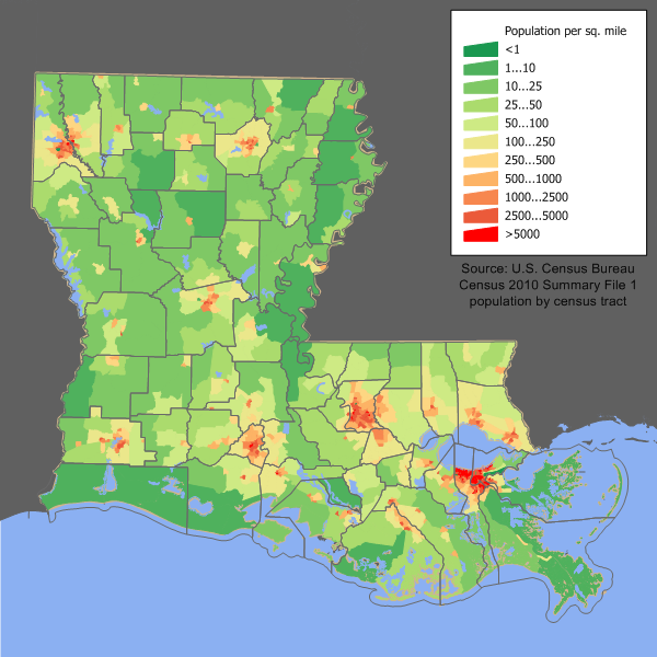
I mean technically that is correct. Cameron County is very sparsely populated. But 30 miles inland the Lake Charles metro got hammered with the eye and had 200,000+ people. There was a tremendous amount of damage from probably no worse than Cat 2/3 winds.
cfisher wrote:LSU2001 wrote:cfisher wrote:It's a balance. OTOH being *too* bullish can make people take future storms less serious, but OTOH you don't have to go back very far in history to see what happens with storms in this position. This site and NHC were way too bearish on Laura, but thankfully it impacted a sparsely populated zone.
edit: also we KNOW lightning near the core is a harbringer of RI. There's no need to patronize people for making predictions based on historical data.
Maybe compared to NOLA or Houston you could say Laura hit a “sparsely populated area” but I assure you here in Louisiana Laura caused massive damage all the way up the southwestern side of La. and all the way up to Monroe. Hundreds of thousands of people were directly impacted as she rode up the state.
It's certainly not unreasonable to say Laura made landfall in an unpopulated area.
https://upload.wikimedia.org/wikipedia/commons/e/ed/Louisiana_population_map.png
2 likes
Re: ATL: SALLY - Tropical Storm - Discussion
TallahasseeMan wrote:Sally does not have to rapidly intensify tonight to be a very powerful hurricane at landfall considering we’re still 36-40 hours away from that.
Sent from my iPhone using Tapatalk
Official RI definition is a 30 kt increase in 24 hr, which is a rate of 1.25 kt/hr. Assuming Sally makes landfall in exactly 40 hours, if she intensified at exactly that rate for the rest of her time over water, she'd be a major at landfall.
3 likes
Who is online
Users browsing this forum: No registered users and 19 guests