ATL: CRISTOBAL - Post-Tropical - Discussion
Moderator: S2k Moderators
-
ConvergenceZone
.gif)
- Category 5

- Posts: 5241
- Joined: Fri Jul 29, 2005 1:40 am
- Location: Northern California
Re: ATL: CRISTOBAL - Tropical Storm - Discussion
Feeling much much better about this than I was a few days ago when I thought a hurricane was going to slam into the northern gulf states. They goodness for all of the dry air and lack of convection.... Also very thankful that it's moving so fast and not just barely moving like past storms. Should be a very short lived event.....
4 likes

Re: ATL: CRISTOBAL - Tropical Storm - Discussion
Salute!
From the Panhandle, I send all a caution. Predictions are tough, especially about the future.
All should look at Elena from 1985 and maybe Erin from 1995. Oh yeah, Betsy in 1965, but she did her dance in the Atlantic before the dive south and then beeline to New Orleans after clearing Key West.
Of all the worst places you can find a storm, the Gulf has to rule the roost. Mainly late in the season, but don't rule out late May and June.
========
Cloudy today and could not see any outflow. However, when the line of storms come from the east versus the west or southwest or..... gotta be some tropical thing going on.
Decent rain, but not torential so far in the Panhandle.
Will report Sunday with the Pensacola folks.
Gums sends...
4 likes
-
ColdFusion

- S2K Supporter

- Posts: 452
- Joined: Wed Feb 13, 2008 3:46 pm
- Location: Addison, TX
Re: ATL: CRISTOBAL - Tropical Storm - Discussion
Grand Isle this morning, doesnt take much...
https://twitter.com/CharlesPeekWX/status/1269302104897839105
https://twitter.com/CharlesPeekWX/status/1269302104897839105
2 likes
-
TheProfessor

- Professional-Met

- Posts: 3506
- Age: 29
- Joined: Tue Dec 03, 2013 10:56 am
- Location: Wichita, Kansas
Re: ATL: CRISTOBAL - Tropical Storm - Discussion
The next 6-12 hours will be telling. As of late good upper level divergence and low level convergence has set up over the center. This is really the first time it's set up over the circulation instead of further east since Cristobal moved back into the Gulf.
7 likes
An alumnus of The Ohio State University.
Your local National Weather Service office is your best source for weather information.
Your local National Weather Service office is your best source for weather information.

Re: ATL: CRISTOBAL - Tropical Storm - Discussion
The waves are getting bigger and bigger by the hour... wind is picking up here on Pensacola beach as well. Rain is coming and going. Sitting on the balcony listening to the waves and drinking a white claw while the kids nap!
5 likes

Re: ATL: CRISTOBAL - Tropical Storm - Discussion
It seems to be making a little Eastward progress looking at this sat loop. The center looks to be at about 89.8 if I'm seeing the center correctly.
https://weather.cod.edu/satrad/?parms=s ... =undefined
https://weather.cod.edu/satrad/?parms=s ... =undefined
1 likes
-
Dean4Storms
- S2K Supporter
- Posts: 6358
- Age: 63
- Joined: Sun Aug 31, 2003 1:01 pm
- Location: Miramar Bch. FL
Re: ATL: CRISTOBAL - Tropical Storm - Discussion
Yep, it has definitely tracked a bit NNE the past couple hours or so.
0 likes
-
NXStumpy_Robothing
- Category 1

- Posts: 335
- Age: 25
- Joined: Fri Jun 05, 2020 11:50 pm
- Location: North Georgia
Re: ATL: CRISTOBAL - Tropical Storm - Discussion
Greetings everyone! I'm a bit new to Storm2k, so I apologize if I mess up my formatting.
Anyway, I had done some backreading in this thread and noticed that not many had mentioned the various low-level mesovortices circling around one another in the center. Generally these are partially or completely covered by mid-level clouds, but Cristobal's current status is giving us a great view of these localized areas of spin and how their interactions can lead to slight wiggles in the storm's track. I'm always fascinated whenever I get to observe these phenomena in real time.
On Cristobal as a whole, I'm a little bit surprised at how well this system has done at keeping a good amount of moisture near the center. Somewhat expected a bit more of the mid-level dry air to work its way in there. And like others in this thread, I'm definitely seeing it swing back a little east after the slight venture west it was on previously.
8 likes
Undergraduate Meteorology Student, Georgia Institute of Technology

-
tarheelprogrammer

- S2K Supporter
- Posts: 1793
- Joined: Mon Mar 28, 2016 9:25 pm
- Location: Raleigh, NC area (Garner, NC)
Re: ATL: CRISTOBAL - Tropical Storm - Discussion
TheProfessor wrote:The next 6-12 hours will be telling. As of late good upper level divergence and low level convergence has set up over the center. This is really the first time it's set up over the circulation instead of further east since Cristobal moved back into the Gulf.
Mid-level dry air has wrapped completely into this storm. If you watch the mid-level wv you can see it clearly. It is running out of time over water as well. Great news for the gulf coast, but they will still experience impacts for sure.
0 likes
My posts are not official forecasts. They are just my opinion and may or may not be backed by sound meteorological data. They are NOT endorsed by any professional institution or storm2k.org. For official information, please refer to the NHC and NWS products.

Re: ATL: CRISTOBAL - Tropical Storm - Discussion
Think we will get some heavy rain/wind gusts tonight for sure
0 likes
-
TheStormExpert
Re: ATL: CRISTOBAL - Tropical Storm - Discussion
So why is it not classified as Subtropical now!? A few days ago I even said it'll likely be Subtropical if anything in the GoM.
Cristobal continues to lack the appearance and structure of a
typical tropical cyclone. In fact, the large radius of maximum
wind and convective bands well removed from the center are more
characteristic of a subtropical cyclone.
typical tropical cyclone. In fact, the large radius of maximum
wind and convective bands well removed from the center are more
characteristic of a subtropical cyclone.
3 likes
-
Stangfriik
- Tropical Storm

- Posts: 114
- Joined: Tue Jul 26, 2005 2:25 pm
- Location: Daytona Beach, Florida
- Contact:
Re: ATL: CRISTOBAL - Tropical Storm - Discussion
Kinda looks like the convection on the west is being left behind?
0 likes
-
TheStormExpert
Re: ATL: CRISTOBAL - Tropical Storm - Discussion
ConvergenceZone wrote:Feeling much much better about this than I was a few days ago when I thought a hurricane was going to slam into the northern gulf states. They goodness for all of the dry air and lack of convection.... Also very thankful that it's moving so fast and not just barely moving like past storms. Should be a very short lived event.....
Cristobal is more of a wake-up reminder that hurricane season is here and now is the time to prepare. Should be in and out with little fanfare.
0 likes

Re: ATL: CRISTOBAL - Tropical Storm - Discussion
Seeing some upper level outflow in the cirrus far west of the CoC.
Even a flash of lightning.
3000 CAPE dead into the core now.
Even a flash of lightning.
3000 CAPE dead into the core now.
Last edited by GCANE on Sat Jun 06, 2020 4:18 pm, edited 1 time in total.
1 likes
-
TheProfessor
- Professional-Met
- Posts: 3506
- Age: 29
- Joined: Tue Dec 03, 2013 10:56 am
- Location: Wichita, Kansas
Re: ATL: CRISTOBAL - Tropical Storm - Discussion
tarheelprogrammer wrote:TheProfessor wrote:The next 6-12 hours will be telling. As of late good upper level divergence and low level convergence has set up over the center. This is really the first time it's set up over the circulation instead of further east since Cristobal moved back into the Gulf.
Mid-level dry air has wrapped completely into this storm. If you watch the mid-level wv you can see it clearly. It is running out of time over water as well. Great news for the gulf coast, but they will still experience impacts for sure.
There's definitely some mid-level dry air in the center that needs to be mixed out, but it's not currently being entrenched into the center. Right now the dry air is bisecting the core of the storm and the feeder band to the east. This is exactly what needs to happen if the core wants to become better organized.

2 likes
An alumnus of The Ohio State University.
Your local National Weather Service office is your best source for weather information.
Your local National Weather Service office is your best source for weather information.
-
ColdMiser123

- Professional-Met
- Posts: 905
- Age: 29
- Joined: Mon Sep 26, 2016 3:26 pm
- Location: Northeast US
Re: ATL: CRISTOBAL - Tropical Storm - Discussion
Cristobal's structure reminds me strongly of Isidore's structure in 2002 after spending a good amount of time over land, almost in the same exact location as well in the Gulf.
Cristobal has about 24 to 30 hours left over water and still remains a broad cyclone. Convection well to the east associated with the feeder band has been weakening, but any kind of effective pressure falls from now until landfall will only happen with more convection focused over the center. With the weakening convection to the east, that might present an opportunity for more convection to be focused closer to the core with diurnal maximum overnight. Convection eventually focused over the core of Isidore, and it did intensify to a 55 KT tropical storm before landfall.
Cristobal has about 24 to 30 hours left over water and still remains a broad cyclone. Convection well to the east associated with the feeder band has been weakening, but any kind of effective pressure falls from now until landfall will only happen with more convection focused over the center. With the weakening convection to the east, that might present an opportunity for more convection to be focused closer to the core with diurnal maximum overnight. Convection eventually focused over the core of Isidore, and it did intensify to a 55 KT tropical storm before landfall.
9 likes
B.S., M.S., Meteorology & Atmospheric Science
Re: ATL: CRISTOBAL - Tropical Storm - Discussion
Expand out a little and switch to UL Water Vapor.
A new feeder band is forming from the IoT, west of the current band, and firing some convection.
TPW is about to cross from the EPAC over the IoT into the BoC.
There is absolutely zero shear over this with 3000 CAPE in the core.
All this has to do is drop pressure a little and the cork comes off.


A new feeder band is forming from the IoT, west of the current band, and firing some convection.
TPW is about to cross from the EPAC over the IoT into the BoC.
There is absolutely zero shear over this with 3000 CAPE in the core.
All this has to do is drop pressure a little and the cork comes off.
1 likes
-
TheStormExpert
Re: ATL: CRISTOBAL - Tropical Storm - Discussion
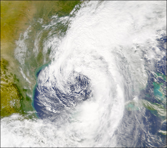
ColdMiser123 wrote:Cristobal's structure reminds me strongly of Isidore's structure in 2002 after spending a good amount of time over land, almost in the same exact location as well in the Gulf.
https://eoimages.gsfc.nasa.gov/images/imagerecords/10000/10206/Isidore_S2002268.jpg
Cristobal has about 24 to 30 hours left over water and still remains a broad cyclone. Convection well to the east associated with the feeder band has been weakening, but any kind of effective pressure falls from now until landfall will only happen with more convection focused over the center. With the weakening convection to the east, that might present an opportunity for more convection to be focused closer to the core with diurnal maximum overnight. Convection eventually focused over the core of Isidore, and it did intensify to a 55 KT tropical storm before landfall.
Here's a more recent comparison with TS Cindy in mid-June 2017. Definitely had a Subtropical look to it as well!

1 likes
-
ColdMiser123
- Professional-Met
- Posts: 905
- Age: 29
- Joined: Mon Sep 26, 2016 3:26 pm
- Location: Northeast US
Re: ATL: CRISTOBAL - Tropical Storm - Discussion
Recon aircraft about to make a N to S pass through the new convection just to the north of the center.
0 likes
B.S., M.S., Meteorology & Atmospheric Science
Who is online
Users browsing this forum: No registered users and 58 guests