ATL: KAREN - Remnants - Discussion
Moderator: S2k Moderators

Re: ATL: KAREN - Tropical Storm - Discussion
Do we need to be concerned about Karen in Florida or is it just going to meander out there?
0 likes
-
wxman57

- Moderator-Pro Met

- Posts: 23178
- Age: 68
- Joined: Sat Jun 21, 2003 8:06 pm
- Location: Houston, TX (southwest)
Re: ATL: KAREN - Tropical Storm - Discussion
boca wrote:Do we need to be concerned about Karen in Florida or is it just going to meander out there?
Some of its moisture could reach the FL Peninsula next week, resulting in enhanced shower activity.
0 likes
-
toad strangler

- S2K Supporter

- Posts: 4546
- Joined: Sun Jul 28, 2013 3:09 pm
- Location: Earth
- Contact:
Re: ATL: KAREN - Tropical Storm - Discussion
wxman57 wrote:boca wrote:Do we need to be concerned about Karen in Florida or is it just going to meander out there?
Some of its moisture could reach the FL Peninsula next week, resulting in enhanced shower activity.
Which would be awesome being it looks like the rainy season has ended early here.
1 likes
My Weather Station
https://www.wunderground.com/dashboard/pws/KFLPORTS603
https://www.wunderground.com/dashboard/pws/KFLPORTS603
-
wxman57
- Moderator-Pro Met
- Posts: 23178
- Age: 68
- Joined: Sat Jun 21, 2003 8:06 pm
- Location: Houston, TX (southwest)
Re: ATL: KAREN - Tropical Storm - Discussion
I don't think there's any LLC under that convection, and NE of the convection looks like a trof axis. However, I did notice something interesting SE of the convection. There is a definite rotation near 26.1N / 66.7W. Not sure what that is. Recon would be nice. I'll bet the NHC forecasters are banging their heads against a wall about now.

7 likes
-
1900hurricane

- Category 5

- Posts: 6063
- Age: 34
- Joined: Fri Feb 06, 2015 12:04 pm
- Location: Houston, TX
- Contact:
Re: ATL: KAREN - Tropical Storm - Discussion
GCANE wrote:GCANE wrote:NDG wrote:
Is there a reason why you posted a wv satellite pix from last night?
Here is the current image:
https://i.imgur.com/10LkD4h.jpg
Its a real-time image I got from Slider of LL WV not mid-level WV.
I wanted to highlight the fact its LL dry air being over run by mid-level moist air.
My bad, I just checked the time stamp, it is old. Sorry.
Not sure why, but RAMMB SLIDER imagery does run behind on occasion. Their Geocolor in particular give me issues sometimes. Usually all the main bands are pretty timely at least.
1 likes
Contract Meteorologist. TAMU & MSST. Fiercely authentic, one of a kind. We are all given free will, so choose a life meant to be lived. We are the Masters of our own Stories.
Opinions expressed are mine alone.
Follow me on Twitter at @1900hurricane : Read blogs at https://1900hurricane.wordpress.com/
Opinions expressed are mine alone.
Follow me on Twitter at @1900hurricane : Read blogs at https://1900hurricane.wordpress.com/

Re: ATL: KAREN - Tropical Storm - Discussion
wxman57 wrote:I don't think there's any LLC under that convection, and NE of the convection looks like a trof axis. However, I did notice something interesting SE of the convection. There is a definite rotation near 26.1N / 66.7W.
http://wxman57.com/images/Karen17.JPG
I was just going to post on that. I was wondering what that was on the visible loop. That would certainly change things if the LLC would take hold over there. Looks interesting.
0 likes
The following post is NOT an official forecast and should not be used as such. It is just the opinion of the poster and may or may not be backed by sound meteorological data. It is NOT endorsed by any professional institution including storm2k.org For Official Information please refer to the NHC and NWS products.
-
Emmett_Brown

- Category 5
- Posts: 1433
- Joined: Wed Aug 24, 2005 9:10 pm
- Location: Sarasota FL
Re: ATL: KAREN - Tropical Storm - Discussion
I think there is a recon flight into Karen at 18Z, correct?
0 likes
-
wxman57
- Moderator-Pro Met
- Posts: 23178
- Age: 68
- Joined: Sat Jun 21, 2003 8:06 pm
- Location: Houston, TX (southwest)
Re: ATL: KAREN - Tropical Storm - Discussion
blp wrote:wxman57 wrote:I don't think there's any LLC under that convection, and NE of the convection looks like a trof axis. However, I did notice something interesting SE of the convection. There is a definite rotation near 26.1N / 66.7W.
http://wxman57.com/images/Karen17.JPG
I was just going to post on that. I was wondering what that was on the visible loop. That would certainly change things if the LLC would take hold over there. Looks interesting.
It's interesting. I don't think it would change Karen's future. It should be dissipating well east of the Bahamas - if it hasn't already dissipated.
1 likes

Re: ATL: KAREN - Tropical Storm - Discussion
wxman57 wrote:I don't think there's any LLC under that convection, and NE of the convection looks like a trof axis. However, I did notice something interesting SE of the convection. There is a definite rotation near 26.1N / 66.7W. Not sure what that is. Recon would be nice. I'll bet the NHC forecasters are banging their heads against a wall about now.
http://wxman57.com/images/Karen17.JPG
Hot off the press, LLC is on the NE edge of the convection as I have said, that rotation you notice near 26.1N/66.7 is the old MLC:

1 likes
-
wxman57
- Moderator-Pro Met
- Posts: 23178
- Age: 68
- Joined: Sat Jun 21, 2003 8:06 pm
- Location: Houston, TX (southwest)
Re: ATL: KAREN - Tropical Storm - Discussion
Here's the NHC's position - east of the convection. I don't disagree with their assessment. Karen's circulation is elongating.

1 likes
Re: ATL: KAREN - Tropical Storm - Discussion
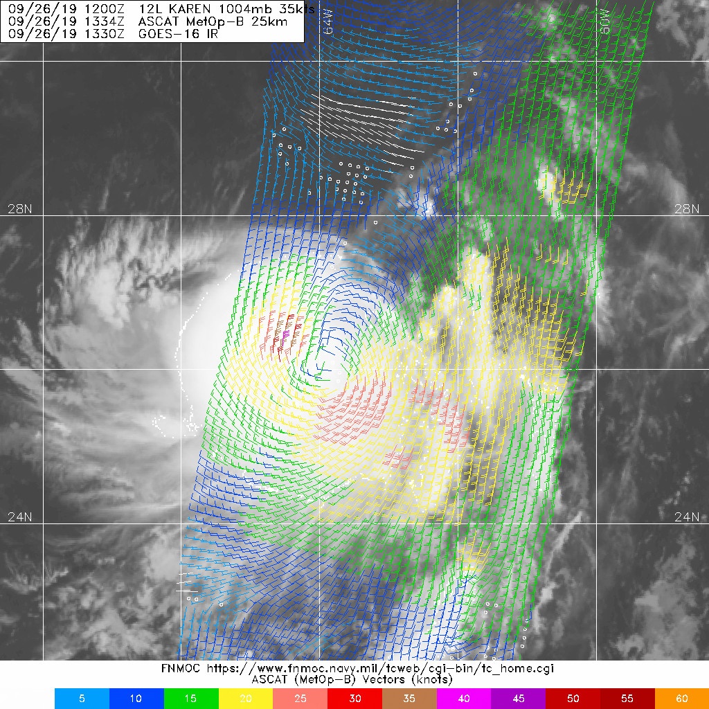
I don't know why NHC is saying elongated. Looks pretty good to me.
3 likes
The following post is NOT an official forecast and should not be used as such. It is just the opinion of the poster and may or may not be backed by sound meteorological data. It is NOT endorsed by any professional institution including storm2k.org For Official Information please refer to the NHC and NWS products.
Re: ATL: KAREN - Tropical Storm - Discussion
blp wrote:I don't know why NHC is saying elongated. Looks pretty good to me.
https://uploads.disquscdn.com/images/581cf5d425885c3a0eb8b1b0f4d245411e6b7eaa4d7a2d1afc090631193413a0.jpg
It is a bit elongated on the NE quadrant but a lot better organized than what it was last night, probably a lot to do with that the NE quadrant is starting to feel the circulation from Jerry's remnant low which still a large circulation.
0 likes
Re: ATL: KAREN - Tropical Storm - Discussion
NDG wrote:blp wrote:I don't know why NHC is saying elongated. Looks pretty good to me.
https://uploads.disquscdn.com/images/581cf5d425885c3a0eb8b1b0f4d245411e6b7eaa4d7a2d1afc090631193413a0.jpg
It is a bit elongated on the NE quadrant but a lot better organized than what it was last night, probably a lot to do with that the NE quadrant is starting to feel the circulation from Jerry's remnant low which still a large circulation.
And right under the convection now. So this should start taking off.
1 likes
The following post is NOT an official forecast and should not be used as such. It is just the opinion of the poster and may or may not be backed by sound meteorological data. It is NOT endorsed by any professional institution including storm2k.org For Official Information please refer to the NHC and NWS products.
Re: ATL: KAREN - Tropical Storm - Discussion
The NHC is forecasting Karen to be a remnant low in 3 to 5 days due to northerly shear,but I’m wondering if that could change?
0 likes
Re: ATL: KAREN - Tropical Storm - Discussion
wxman57 wrote:blp wrote:wxman57 wrote:I don't think there's any LLC under that convection, and NE of the convection looks like a trof axis. However, I did notice something interesting SE of the convection. There is a definite rotation near 26.1N / 66.7W.
http://wxman57.com/images/Karen17.JPG
I was just going to post on that. I was wondering what that was on the visible loop. That would certainly change things if the LLC would take hold over there. Looks interesting.
It's interesting. I don't think it would change Karen's future. It should be dissipating well east of the Bahamas - if it hasn't already dissipated.
IF that circulation near 66.7 noted by 57 were to somehow take over (no reason to expect that as of now), it would be ~225 miles WSW of the current LLC/model consensus, which would mean future model runs once incorporating this could markedly change.
Last edited by LarryWx on Thu Sep 26, 2019 10:24 am, edited 1 time in total.
0 likes
Personal Forecast Disclaimer:
The posts in this forum are NOT official forecasts and should not be used as such. They are just the opinion of the poster and may or may not be backed by sound meteorological data. They are NOT endorsed by any professional institution or storm2k.org. For official information, please refer to the NHC and NWS products.
The posts in this forum are NOT official forecasts and should not be used as such. They are just the opinion of the poster and may or may not be backed by sound meteorological data. They are NOT endorsed by any professional institution or storm2k.org. For official information, please refer to the NHC and NWS products.
-
Emmett_Brown
- Category 5
- Posts: 1433
- Joined: Wed Aug 24, 2005 9:10 pm
- Location: Sarasota FL
Re: ATL: KAREN - Tropical Storm - Discussion
blp wrote:I don't know why NHC is saying elongated. Looks pretty good to me.
https://uploads.disquscdn.com/images/581cf5d425885c3a0eb8b1b0f4d245411e6b7eaa4d7a2d1afc090631193413a0.jpg
A nice large area of W and NW winds on that image as well, so there is definitely a closed circulation
0 likes
-
Aric Dunn
- Category 5
- Posts: 21238
- Age: 43
- Joined: Sun Sep 19, 2004 9:58 pm
- Location: Ready for the Chase.
- Contact:
Re: ATL: KAREN - Tropical Storm - Discussion
Anyone else want to say its not closed.. ?
Also the nhc has to follow the guidance to a degree. Trends will determine what the models do and thus what nhc forecasts. Sooo we have to wait
Also the nhc has to follow the guidance to a degree. Trends will determine what the models do and thus what nhc forecasts. Sooo we have to wait
1 likes
Note: If I make a post that is brief. Please refer back to previous posts for the analysis or reasoning. I do not re-write/qoute what my initial post said each time.
If there is nothing before... then just ask
Space & Atmospheric Physicist, Embry-Riddle Aeronautical University,
I believe the sky is falling...
If there is nothing before... then just ask
Space & Atmospheric Physicist, Embry-Riddle Aeronautical University,
I believe the sky is falling...


-
EquusStorm
- Category 5
- Posts: 1649
- Age: 35
- Joined: Thu Nov 07, 2013 1:04 pm
- Location: Jasper, AL
- Contact:
Re: ATL: KAREN - Tropical Storm - Discussion
What a weird and frustrating storm. Good thing it's doing that in about as middle of nowhere as you can get for a west Atlantic storm.
0 likes
Colors of lost purpose on the canvas of irrelevance
Not a meteorologist, in fact more of an idiot than anything. You should probably check with the NHC or a local NWS office for official information.
Not a meteorologist, in fact more of an idiot than anything. You should probably check with the NHC or a local NWS office for official information.
Who is online
Users browsing this forum: No registered users and 28 guests